Fishing in Wright County, Minnesota
Seat: Buffalo. Metro region.
- 91lakes
- 81accesses
- 1trout streams
 Pick for troutPiscifun Carbon X ultralight spinning reel28% OFFSale $57.99
Photo, nearby stand in for Wright County: Jonathan Miske, CC BY-SA 2.0

Key facts on Wright County
With Buffalo as its seat, Wright County belongs to the Metro region. Within the county lie 661 square miles of land and 53.2 of lakes and rivers.
The county holds 91 lake pages covering 24,714 acres; Clearwater Lake, Wright County is the largest. The DNR access layer shows 81 public water accesses in the county, 61 of them trailer launches. 1 stream in Wright County are designated trout water. Catch tables cover 91 lakes, with walleye in 53. Fishing from shore: 16 DNR piers and sites.
 For the trout herePiscifun Carbon XT ultralight spinning reel25% OFFSale $59.99
Lakes and rivers of Wright County on a map
Minnesota DNR access and fishing site layers and LakeFinder, checked October 2026.
Lake list for Wright County
| Lake | Acres | Max depth ft | Accesses | Walleye per gill net |
|---|---|---|---|---|
| Clearwater Lake, Wright County | 3,187 | 73 | 2 | 1.73 |
| Buffalo Lake, Wright County | 1,552 | 33 | 3 | 13.9 |
| Francis Lake, Meeker County | 1,053 | 17 | 1 | 0.42 |
| Sugar Lake, Wright County | 1,014 | 69 | 2 | 2.08 |
| West Lake Sylvia | 904 | 97 | 1 | 1.88 |
| Pulaski Lake | 813 | 87 | 1 | 2.83 |
| Cedar Lake near Annandale, Wright County | 790 | 108 | 2 | 1.75 |
| Howard Lake, Wright County | 745 | 39 | 3 | 5.33 |
| East Lake Sylvia | 669 | 78 | 0 | 2.38 |
| Collinwood Lake | 639 | 28 | 3 | 0.11 |
| Upper Maple Lake | 633 | 76 | 2 | 1.11 |
| Pleasant Lake, Wright County | 597 | 74 | 2 | 4.33 |
| Cokato Lake | 553 | 52 | 1 | 8.11 |
| Waverly Lake | 494 | 70.5 | 2 | 4.11 |
| Fountain Lake, Wright County | 435 | 10 | 1 | |
| Lake John | 397 | 28 | 1 | 3.11 |
| Ann Lake, Wright County | 375 | 18.5 | 1 | 3.12 |
| Granite Lake, Wright County | 362 | 34 | 1 | 3.67 |
| French Lake, Wright County | 346 | 50 | 1 | 9 |
| Little Waverly Lake | 338 | 12 | 1 | |
| Beebe Lake | 323 | 27 | 1 | 6.17 |
| Ramsey Lake | 317 | 80 | 1 | 2.67 |
| Mink/Somers Lake | 280 | 39 | 1 | 2.4 |
| Henshaw Lake | 272 | 8 | 0 | |
| Charlotte Lake, Wright County | 253 | 46 | 1 | |
| Smith Lake, Wright County | 244 | 5 | 1 | |
| Limestone Lake | 234 | 34 | 1 | 0.5 |
| Ida Lake near Monticello, Wright County | 226 | 60 | 1 | |
| Bass Lake, Wright County | 222 | 34 | 1 | |
| Cedar Lake near Monticello, Wright County | 206 | 47 | 0 | |
| Millstone Lake | 200 | 8.5 | 1 | |
| Mary Lake near Maple Lake, Wright County | 196 | 102 | 1 | 2 |
| Louisa Lake, Stearns County | 193 | 44 | 0 | 0.83 |
| Eagle Lake, Wright County | 191 | 38 | 1 | 1.5 |
| Mary Lake near Winsted, Wright County | 190 | 46 | 0 | 4 |
| Emma Lake | 189 | 16 | 1 | 0.17 |
| Augusta Lake, Wright County | 187 | 82 | 0 | 1.8 |
| Rock Lake, Wright County | 183 | 37 | 1 | 5.33 |
| Dean Lake | 176 | 20 | 1 | 2.83 |
| Constance Lake | 175 | 23 | 1 | |
| Deer Lake, Wright County | 171 | 27 | 1 | 5.67 |
| Dutch Lake, Wright County | 162 | 21 | 1 | |
| Washington Lake, Wright County | 155 | 21 | 0 | |
| Somers Lake | 151 | 21 | 0 | 1.8 |
| Marie Lake, Wright County | 146 | 36 | 1 | 1.5 |
| Locke Lake, Wright County | 140 | 49 | 1 | 2.67 |
| Indian Lake, Wright County | 139 | 31 | 1 | |
| Maple Lake, Meeker County | 139 | 7 | 0 | |
| Caroline Lake | 137 | 45 | 0 | 1.83 |
| Camp Lake, Wright County | 123 | 52 | 1 | 3.75 |
| Foster Lake | 115 | 10 | 0 | 0.5 |
| Yaeger Lake, Wright County | 111 | 28 | 0 | |
| Bertram Lake | 111 | 44 | 0 | |
| Crawford Lake | 110 | 19 | 1 | 2 |
| Martha Lake | 102 | 22 | 1 | 0.33 |
| Brooks Lake | 100 | 21 | 1 | 0.25 |
| Birch Lake near Monticello, Wright County | 100 | 52 | 1 | |
| Birch Lake near Buffalo, Wright County | 99 | 26 | 0 | |
| Black Lake, Wright County | 98 | 50 | 0 | |
| Fish Lake, Wright County | 97 | 38 | 1 | 0.5 |
- Dog Lake97 acres
- Long Lake, Wright County96 acres
- Mink Lake, Wright County94 acres
- Union Lake, Wright County93 acres
- Rice Lake, Wright County92 acres
- Moose Lake, Wright County87 acres
- Ida Lake near Winsted, Wright County85 acres
- Silver Lake, Wright County83 acres
- Scott Lake, Wright County83 acres
- Dans Lake81 acres
- Grass Lake, Wright County71 acres
- Sullivan Lake, Wright County71 acres
- Light Foot Lake69 acres
- Nixon Lake60 acres
- Ember Lake59 acres
- Albert Lake58 acres
- Mud Lake near Cokato, Wright County57 acres
- Chelgren Lake54 acres
- Goose Lake, Wright County52 acres
- Sheldon Lake50 acres
- North Twin Lake, Wright County49 acres
- Round Lake, Wright County45 acres
- South Twin Lake, Wright County44 acres
- Wiegand Lake42 acres
- Little Rock Lake, Wright County37 acres
- Little Eagle Lake36 acres
- Mud Lake near Monticello, Wright County33 acres
- North Berthiaume Lake24 acres
- Pickeral Lake, Wright County20 acres
- South Berthiaume Lake20 acres
- First Lake, Wright County17 acres
DNR LakeFinder morphology, access layer and latest survey per lake.
Lesser lakes of Wright County
Wright County has 17 additional DNR waters, listed here with what the DNR publishes.
| Water | Acres | Max depth ft | DNR number | Accesses |
|---|---|---|---|---|
| Tamarack Lake, Wright County | 62 | 26 | 86008900 | 0 |
| Maxim Lake | 46 | 18 | 86021800 | 0 |
| Fadden Lake | 20 | 48 | 86010900 | 0 |
| Unnamed (Clearwater) | 15 | 37 | 86024700 | 0 |
| Unnamed (Annandale) | 8 | 32 | 86032000 | 0 |
| Green Mountain Lake | 9 | 86006300 | 1 | |
| Little Mary (North Bay) | 86013902 | 0 | ||
| Little Mary (South Bay) | 86013901 | 0 | ||
| Little Mary Lake | 15.2 | 86013900 | 1 | |
| Maple (Northeast Bay) | 86013403 | 0 | ||
| Maple Lake, Wright County | 86013400 | 0 | ||
| Mud Lake near Maple Lake, Wright County | 0.9 | 86013402 | 0 | |
| North Lake, Wright County | 86017400 | 1 | ||
| Pelican Lake, Wright County | 13.2 | 86003100 | 3 | |
| School Section Lake, Wright County | 86018000 | 1 | ||
| Shakopee Lake, Wright County | 86025500 | 1 | ||
| White Lake, Wright County | 86021400 | 1 |
Minnesota DNR LakeFinder, checked October 2026.
Wright County river pages
- Mississippi Riverriver, 151 accesses
- Crow Riverriver, 15 accesses
- Crow River, South Forkriver, 5 accesses
- Clearwater River, Wright Countyriver, 1 access
Trout-designated streams of Wright County
The county holds 1 more designated trout streams, listed with their mapped length.
- Thiel Creek0.8 mi, near South Haven
USGS sites in Wright County
| USGS gauge | Latest reading | Time (ET) |
|---|---|---|
| Crow River At Rockford, Mn | 1,780 cfs, 4.65 ft gage height | Nov 9 11:00 pm |
US Geological Survey provisional data, retrieved Nov 9, 2026 11:33 pm ET. Provisional readings can be revised.
DNR designated trout stream layer.
Boat landings across Wright County
- Ann Lake Access near Howard LakeAnn, 1 ramp, 10 trailer stalls, 1 dock, toilet
- Bass Lake Access near AnnandaleBass, 1 ramp, 10 trailer stalls, 1 dock, toilet
- Beebe Lake AccessBeebe, 1 ramp, 12 trailer stalls, 1 dock, toilet
- Birch Lake Access near MonticelloBirch, 1 ramp, 2 trailer stalls
- Brooks Lake AccessBrooks, 1 ramp, 3 trailer stalls, toilet
- Buffalo Lake (E) AccessBuffalo, 1 ramp, 15 trailer stalls, 1 dock, toilet
- Buffalo Lake (N) AccessBuffalo, 1 ramp, 24 trailer stalls, 1 dock, toilet
- Buffalo Lake (S) Access near BuffaloBuffalo, 1 ramp
- Camp (Henry) Lake AccessCamp, 1 ramp, 5 trailer stalls, 1 dock
- Cedar Lake (W) AccessCedar, 1 ramp, 10 trailer stalls, 1 dock, toilet
- Cedar Lake, Schroeder Park AccessCedar, 1 ramp, toilet
- Charlotte Lake Access near St. MichaelCharlotte, 1 ramp, 2 trailer stalls
- Cokato Lake AccessCokato, 1 ramp, 10 trailer stalls, 1 dock, toilet
- Collinwood Lake (E) AccessCollinwood, 1 ramp, 1 dock
- Collinwood Lake (S) AccessCollinwood, 1 ramp, 1 dock
- Constance Lake AccessConstance, 1 ramp, 6 trailer stalls
- Crawford Lake AccessCrawford, 1 ramp, 8 trailer stalls
- Crow River, Bill Anderson Park AccessNorth Fork Crow River, 1 ramp
- Crow River, Crow Springs Park AccessNorth Fork Crow River, 1 ramp, toilet
- Crow River, Riverside Park AccessNorth Fork Crow River, 1 ramp
- Crow River, Wildlife Park AccessNorth Fork Crow River, 1 ramp
- Dean Lake Access near BuffaloDean, 1 ramp, 6 trailer stalls, 1 dock
- Deer Lake Access near BuffaloDeer, 1 ramp, 10 trailer stalls, 1 dock
- Dog Lake, Johnson Park AccessDog, 1 ramp, 3 trailer stalls, 1 dock
- Dutch Lake Access near Howard LakeDutch, 1 ramp, 4 trailer stalls, 1 dock
- Eagle Lake Access near MonticelloEagle, 1 ramp, 8 trailer stalls, 1 dock
- Emma Lake AccessEmma, 1 ramp, 2 trailer stalls
- Fish Lake Access near ClearwaterFish, 1 ramp
- Fountain Lake AccessFountain, 1 ramp, 2 trailer stalls
- French Lake Access near AnnandaleFrench, 1 ramp, 14 trailer stalls, 1 dock, toilet
- Granite Lake AccessGranite, 1 ramp, 11 trailer stalls, 1 dock
- Green Mountain Lake AccessGreen Mountain, 1 ramp, 1 trailer stalls
- Howard Lake (N) AccessHoward, 1 ramp
- Howard Lake, Lions Park AccessHoward, 2 ramps, 1 dock, toilet
- Howard Lake, Memorial Park AccessHoward, 1 ramp
- Ida Lake Access near MonticelloIda, 1 ramp, 10 trailer stalls, 1 dock
- Indian Lake Access near Maple LakeIndian, 1 ramp, 4 trailer stalls, 1 dock
- Lake John, Huikko Landing AccessJohn, 1 ramp, 19 trailer stalls, 1 dock, toilet
- Limestone Lake AccessLimestone, 1 ramp, 5 trailer stalls
- Little Eagle Lake AccessLittle Eagle, 1 ramp, 2 trailer stalls
- Little Mary Lake (Maria), Lake Maria SPK AccessLittle Mary, 1 ramp, 20 trailer stalls, 2 docks, toilet
- Little Waverly Lake AccessLittle Waverly, 1 ramp
- Locke Lake Access near BeckerLocke, 1 ramp, 6 trailer stalls, 1 dock, toilet
- Maple Lake (E) Access near Maple LakeUpper Maple, 1 ramp, 4 trailer stalls, 1 dock
- Maple Lake (W) AccessUpper Maple, 1 ramp, 5 trailer stalls, 1 dock
- Martha Lake AccessMartha, 1 ramp, 2 trailer stalls
- Mary Lake Access near Maple LakeMary, 1 ramp, 8 trailer stalls, 1 dock
- Millstone Lake AccessMillstone, 1 ramp, 5 trailer stalls
- Mink/Somers Lake AccessMink, 1 ramp, 5 trailer stalls, 1 dock
- Mississippi River, Ellison Park AccessMississippi River, 1 ramp, 4 trailer stalls, toilet
- Mississippi River, Montissippi Park AccessMississippi River, 1 ramp, 10 trailer stalls, toilet
- Mississippi River, Norin Landing AccessMississippi River, 1 ramp
- Mississippi River, Otsego Park AccessMississippi River, 1 ramp, toilet
- Moses Lake Access near KingstonMoose, 1 ramp
- Mud Lake, Skifstrom AccessMud, 1 ramp, 1 dock
- Nixon Lake AccessNixon, 1 ramp
- North Fork Crow River, Albright's Mill AccessNorth Fork Crow River, 1 ramp
- North Fork Crow River, Betty T Mason AccessNorth Fork Crow River, carry-in access
- North Fork Crow River, Crow Hassen Park Reserve N AccessNorth Fork Crow River, carry-in access
- North Fork Crow River, Humphrey Arends AccessNorth Fork Crow River, 1 ramp
- North Fork Crow River, Rockford AccessNorth Fork Crow River, 1 ramp, 9 trailer stalls
- North Lake, Harry Larson Park AccessNorth, 1 ramp
- Pelican Lake (SW) AccessPelican, 1 ramp
- Pelican Lake (W) Access near MonticelloPelican, 1 ramp, 30 trailer stalls, 1 dock, toilet
- Pelican Lake WMA (N) Holker's Landing AccessPelican, 1 ramp, 26 trailer stalls, 1 dock
- Pleasant Lake (N) AccessPleasant, 1 ramp, 12 trailer stalls, 1 dock, toilet
- Pleasant Lake (S) AccessPleasant, 1 ramp, 8 trailer stalls, toilet
- Pulaski Lake, Griffing Park AccessPulaski, 2 ramps, 1 dock, toilet
- Ramsey Lake AccessRamsey, 1 ramp, 10 trailer stalls, 1 dock, toilet
- Rock Lake Access near Maple LakeRock, 1 ramp, 10 trailer stalls, 1 dock
- School Section Lake Access near WaverlySchool Section, 1 ramp, 1 trailer stalls
- Shakopee Lake Access near Silver LakeShakopee, 1 ramp, 2 trailer stalls
- Smith Lake Access near Howard LakeSmith, 1 ramp, 2 trailer stalls
- Sugar Lake (N) AccessSugar, 1 ramp, 5 trailer stalls, 1 dock
- Sugar Lake (S) AccessSugar, 1 ramp, 17 trailer stalls, 1 dock, toilet
- Sullivan Lake Access near Maple LakeSullivan, 1 ramp, 6 trailer stalls, 1 dock
- Twin/Sylvia Lake AccessWest Lake Sylvia, 1 ramp, 25 trailer stalls, 2 docks, toilet
- Union Lake Access near South HavenUnion, 1 ramp, 10 trailer stalls, 1 dock
- Waverly Lake AccessWaverly, 1 ramp, toilet
- Waverly Lake, Waterfront Park AccessWaverly, 1 ramp, 1 dock, toilet
- White Lake Access near Maple LakeWhite, 1 ramp, 2 trailer stalls
DNR fishing piers across Wright County (16)
- Beebe Lake Fishing Pierfishing pier, Beebe
- Big Waverly Lake Fishing Pierfishing pier, Waverly
- Brooks Lake Fishing Pierfishing pier, Brooks
- Buffalo Lake Fishing Pier, Buffalo Lake (S) Public Water Access Sitefishing pier, Buffalo
- Buffalo Lake Fishing Pier, Wright County 1fishing pier, Buffalo
- Buffalo Lake Fishing Pier, Wright County 2fishing pier, Buffalo
- Cedar Lake Fishing Pier, Wright Countyfishing pier, Cedar
- Collinwood Lake Fishing Pierfishing pier, Collinwood
- Howard Lake Fishing Pierfishing pier, Howard
- Lake Maria Fishing Pierfishing pier, Little Mary
- Maple Lake Fishing Pier, Maple Lake (W) Public Water Access Sitefishing pier, Upper Maple
- Mississippi River – Monticello Fishing Pierfishing pier,
- Mississippi River – Montissippi County Park Fishing Pierfishing pier,
- Mud Lake Fishing Pierfishing pier, Mud
- Pleasant Lake Fishing Pier, Pleasant Lake (N) Public Water Access Sitefishing pier, Pleasant
- Pleasant Lake Fishing Pier, Pleasant Lake (S) Public Water Access Sitefishing pier, Pleasant
Minnesota DNR Public Water Access Sites and Public Fishing Sites.
Wright County stocking rows and record fish
Wright County stocking on file
| Water | Species | Number | Year |
|---|---|---|---|
| Ann | Walleye | 3,777 | 2017 |
| Beebe | Walleye | 2,160 | 2017 |
| Cedar | Walleye | 3,694 | 2017 |
| Clearwater | Walleye | 1,500,000 | 2017 |
| Cokato | Walleye | 184,000 | 2017 |
| Crawford | Walleye | 171 | 2017 |
| Dean | Walleye | 1,837 | 2017 |
| French | Walleye | 2,976 | 2017 |
| Granite | Walleye | 3,480 | 2017 |
| Howard | Walleye | 6,631 | 2017 |
| Locke | Walleye | 134,000 | 2017 |
| Pleasant | Walleye | 2,146 | 2017 |
| Ramsey | Walleye | 1,287 | 2017 |
| Sugar | Walleye | 2,698 | 2017 |
Heaviest fish from Wright County
| Species | Weight | Water |
|---|---|---|
| Common Carp | 55 lb 5 oz | Clearwater Lake |
| White Crappie | 3 lb 15 oz | Lake Constance |
DNR area fisheries stocking pages and state records; area pages list mostly 2015 to 2017 reports and standing plans.
Statewide rows for Wright County
| Species | Limit | Season |
|---|---|---|
| Walleye and sauger | 6 combined total (only 1 walleye over 20" in possession) | May 9, 2026 – Feb. 28, 2027 |
| Northern pike (North-central Zone) | 10 (not more than 2 over 26", all from 22-26" must be immediately released) | May 9, 2026 – Feb. 28, 2027 |
| Northern pike (North-central Zone) | 10 (either 2 northern pike over 26" and none from 22 to 26" or 1 from 22 to 26" and 1 over 26") | Nov. 15, 2026 – Feb. 28, 2027 except where prohibited |
| Largemouth bass | Catch-and-release only | March 1 – May 22, 2026 |
| Largemouth bass | 6 combined total largemouth or smallmouth bass (when smallmouth season is open) | May 23, 2026 – Feb. 28, 2027 |
| Smallmouth bass | Catch-and-release only | March 1 – May 22, 2026 |
| Smallmouth bass | 6 combined total largemouth or smallmouth bass | May 23 – Sept. 13, 2026 |
| Smallmouth bass | Catch-and-release only | Sept. 14, 2026 – Feb. 28, 2027 |
| Crappie | 10 combined total | Continuous |
| Sunfish | 20 combined total | Continuous |
| Yellow perch | 20 daily, 40 in possession | Continuous |
| Muskellunge | 1 (minimum size 54") | June 6 – Nov. 30, 2026 |
| Channel catfish | 5 (only 1 over 24") | Continuous |
| Rock bass | 30 | Continuous |
| Cisco (tullibee) | 15 (over 7") | Continuous |
| Burbot (eelpout) | 4 | Continuous |
| Stream trout | 5 combined total (only 1 over 16") | April 11 – Sept. 30, 2026 |
Map position of Buffalo: North-central Zone.
2026 Minnesota Fishing Regulations; lake pages show any special regulation.
Competition in Wright County
| Date | Event | Water |
|---|---|---|
| 2027-02-06 | 2027 Maple Lake Ice Fishing Derby (52nd annual) | Maple Lake |
| 2026-09-26 | 2026 DM Memorial Bronzeback Classic | Mississippi River |
| 2026-08-09 | 2026 Super 6 | Clearwater Lake |
| 2026-07-26 | 2026 GreenHorn OptiCast Series Tournament 4 of 5 | Clearwater Lake |
| 2026-07-15 | 2026 MNJBN Southwest Metro Conference Open #3 | Clearwater Lake |
| 2026-07-11 | 2026 Waverly Lake 31st Annual Waverly Daze Contest | Waverly Lake |
| 2026-06-28 | 2026 OptiCast ADVANCED Series Tournament 2 of 5 | Clearwater Lake |
| 2026-06-27 | 2026 Good Neighbor Days Fishing Contest | Howard Lake |
| 2026-06-21 | 2026 Minnesota Bass Federation – Clearwater | Clearwater Lake |
| 2026-06-15 | 2026 MNJBN NW Metro Open #1 | Clearwater Lake |
| 2026-06-14 | 2026 OptiCast ADVANCED Series Tournament 1 of 5 | Buffalo Lake |
| 2026-05-30 | 2026 Minneapolis Fire Dept Local 82 | Clearwater Lake |
| 2026-05-17 | 2026 SATT Metro Region | Clearwater Lake |
| 2026-02-07 | 2026 Maple Lake Ice Fishing Derby (51st annual) | Maple Lake |
Buying tackle in Wright County
Bait counters, Wright County
- Monticello Bait & Tacklebait and tackle shop, Monticello
- All Seasons Sportssporting goods store, Delano
- Clancys Outdoorssporting goods store, Monticello
- Fleet Farm, 320 Chelsea Road Westsporting goods store, Monticello
- Grumpy's Outdoorssporting goods store, Maple Lake
- H&H Sports Shopsporting goods store, Maple Lake
- HunterTechsporting goods store, Buffalo
- Joe's Sport Shopsporting goods store, Howard Lake
- Little Jim's Sportssporting goods store, Annandale
- Niccum Dock Servicemarina, Buffalo
- Otter Outdoorssporting goods store, Maple Lake
- Runningsfarm and general store with fishing supplies, Monticello
- South Haven Sportssporting goods store, South Haven
Wright County guides
- Big Dog Guide Servicefishing guide (season not stated), Howard Lake, (612) 810-7330
- Jiggin Jim's Fishing Guide Service & Ryks Taxidermyfishing guide (season not stated), Buffalo, (612) 644-7657
- Chartered Ice Fishingice and open water guide / outfitter, Annandale, (320) 310-9089
In the neighborhood of Wright County
Wright County towns
- Otsegopop. 19,966
- St. Michaelpop. 18,235
- Buffalopop. 16,168
- Monticellopop. 14,455
- Albertvillepop. 7,896
- Delanopop. 6,484
- Rockfordpop. 4,500
- Montrosepop. 3,775
- Hanoverpop. 3,548
- Annandalepop. 3,330
- Cokatopop. 2,799
- Maple Lakepop. 2,159
- Howard Lakepop. 2,071
- Clearwaterpop. 1,922
Over the line from Wright County
- Sherburne County21 miles northeast
- Carver County26 miles south
- Hennepin County27 miles southeast
- Meeker County28 miles west
Species in the nets at Wright County
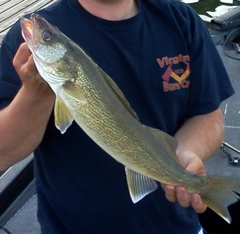
Photo: Virginia State Parks staff, CC BY 2.0

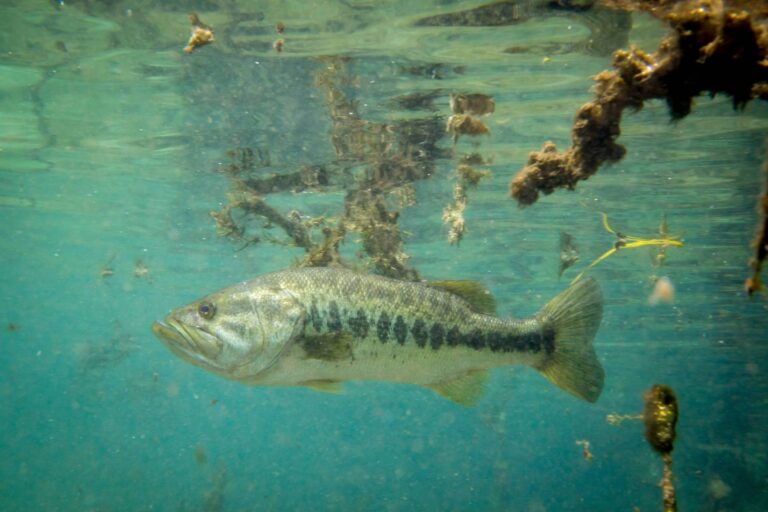
Photo: United States Fish and Wildlife Services, Public domain

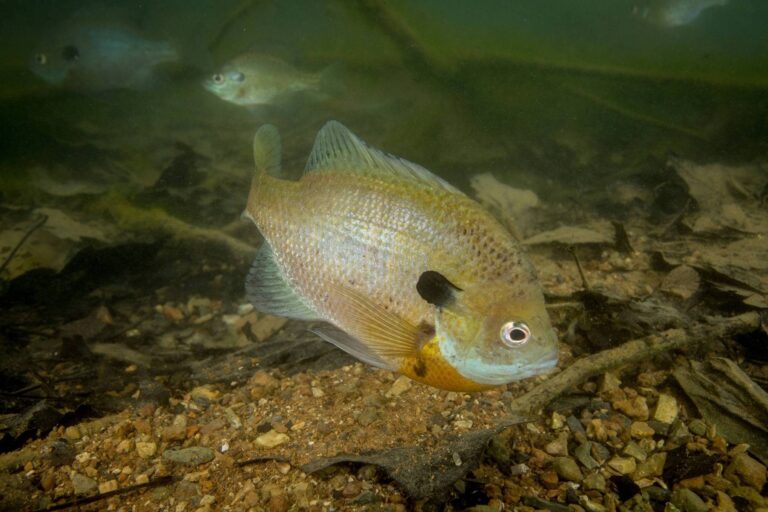
Photo: United States Fish and Wildlife Services, Public domain

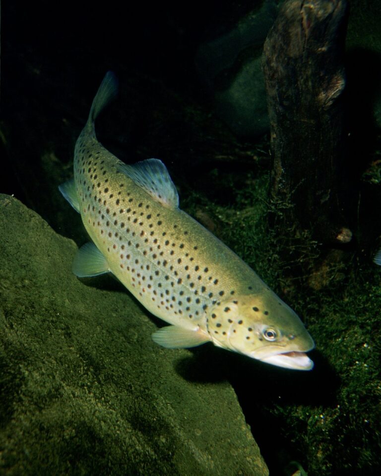
Photo: Eric Engbretson for U.S. Fish and Wildlife Service, Public domain

Wright County angling, asked by readers
How many boat landings does Wright County have?
The county has 81 public accesses (61 for trailers).
Which lake tops the list in Wright County?
Clearwater Lake, Wright County, 3,187 acres.
Where is trout water in Wright County?
The DNR designates 1 stream here.
Which pike zone is Wright County in?
Buffalo falls in the North-central Zone, so those rows apply.
Which stores sell fishing gear in Wright County?
13 shops; Monticello Bait & Tackle is one.
Which outfitters operate in Wright County?
3 guides and outfitters list the county.
Are walleye found in Wright County lakes?
91 lakes carry DNR catch tables, 53 with walleye.
Which city is the county seat of Wright County?
County offices sit in Buffalo.
Which Minnesota license covers Wright County?
Minnesota residents 16 to 89 need an angling license ($25 for the year); nonresidents 16 and older pay $51. Designated trout water takes a Minnesota angling license ($25 resident, $51 nonresident) and the $10 trout and salmon stamp validation for ages 18 to 64.