Tidal Rappahannock River Fishing
A Commonwealth river crossing Caroline County and 5 other localities.
 Pick for troutPiscifun Carbon X ultralight spinning reel28% OFFSale $57.99
Photo: Ken Lund, CC BY-SA 2.0
What a Virginia angler should know about Tidal Rappahannock River
This river, Tidal Rappahannock River, flows through Caroline County and 5 other localities. The nearest town on the Census list is Tappahannock, some 11 miles away.
You can put in at 9 access sites DWR records. Near its mouth the river runs tidal.
Virginia DWR waterbody pages, Stocked Trout Reaches and Cold Water Stream Survey layers and Boating Access Locations; USGS gauges; read November 6, 2026.
 For the trout herePiscifun Carbon XT ultralight spinning reel25% OFFSale $59.99
The fish DWR records for Tidal Rappahannock River
DWR labels alone drive the Tidal Rappahannock River list.
Virginia DWR waterbody page (updated 11/17/2023), read November 6, 2026.
Backing down a trailer at Tidal Rappahannock River
| Site | Recorded attributes | Owner | Location (DWR) |
|---|---|---|---|
| Carter's Wharf on Tidal Rappahannock River | dock and ramp, 1 ramp, freshwater | VDOT | From Warsaw, Rt 3 West (2); Rt 624 North (10.8); L on Rt 622 (2) |
| City Docks boat ramp on Tidal Rappahannock River | dock and ramp, 2 ramps, barrier-free, freshwater | DWR | City of Fredericksburg on Sophia Street |
| Hopyard Landing on Tidal Rappahannock River | dock and ramp, 1 ramp, barrier-free, freshwater | DWR | From Rt. 301 North of Rapp. River, West on Rt. 607 (4.5 mi.), South on Old Wharf Road, f |
| Mill Creek boat ramp on Tidal Rappahannock River | dock and ramp, 1 ramp, barrier-free, saltwater | VDOT | From Hartfield, Rt. 3 North (.5); R on Rt 626 (3.1) |
| Port Royal boat ramp on Tidal Rappahannock River | hand launch (gravel), 1 ramp, barrier-free, freshwater | Town of Port Royal | End of King Street (1 block east of Rt. 301) |
| Saluda boat ramp on Tidal Rappahannock River | dock and ramp, 1 ramp, barrier-free, saltwater | VDOT | Rt 618 North (1.4) of Saluda |
| Simonson Landing on Tidal Rappahannock River | dock and ramp, 1 ramp, saltwater | VDOT | From Farnham, Rt 3 East to Rt 608 South to Rt 606 to ramp |
| Windmill Point Landing on Tidal Rappahannock River | ramp, 1 ramp, barrier-free, saltwater | No File | Windmill Pt. Rd. for 7.2 mi, turn lft. on Windjammer Ln. .2mi ramp on Rt |
| Windmill Point on Tidal Rappahannock River | dock and ramp, 1 ramp, saltwater | Lancaster County | From Whitestone (Rt.3), turn East on Chesapeake Dr., in 0.3 mi. continue onto Windmill P |
Bank access a short walk from Tidal Rappahannock River
- City Dock on Tidal Rappahannock Riverfishing pier
Fallback Commonwealth launches near Tidal Rappahannock River
- Chandlers Mill Pond boat rampChandler’s Mill Pond, 5 miles northeast
- Hoskin's Creek boat ramp on Chesapeake BayChesapeake Bay, 11 miles south
Virginia DWR Boating Access Locations layer (attributes as recorded; lanes, fees and hours are not in the layer), read November 6, 2026.
Tidewater miles of the Rappahannock River
- Mouth (GNIS)Lancaster County
- Fall line landmark (digest)Rt. 1 Bridge
- Freshwater/saltwater license line (digest)Rt. 360 Bridge
- NoteTidal reach and saltwater-license boundary per VMRC/DWR, not given by GNIS.
Above the license line on Tidal Rappahannock River a freshwater license is needed; below it, a saltwater license.
| Species | Area | Size | Bag | Season | VAC section |
|---|---|---|---|---|---|
| Atlantic croaker | Virginia tidal waters | not stated | 50 | not stated | 4VAC20-1370-30 |
| Red drum | Virginia tidal waters | 18 in minimum, 26 in maximum | 3 | not stated | 4VAC20-1400-30 |
| Spot | Virginia tidal waters | not stated | 50 | not stated | 4VAC20-1380-30 |
| Striped bass | Chesapeake Bay and its tributaries (spring/summer) | 19 in minimum, 24 in maximum | 1 | May 16 through June 15 | 4VAC20-252-80 |
| Striped bass | Chesapeake Bay and its tributaries (fall) | 19 in minimum, 24 in maximum | 1 | October 4 through December 31 | 4VAC20-252-90 |
| Striped bass | Potomac River tributaries | 19 in minimum, 24 in maximum | 1 | May 16 through July 6 and August 21 through December 31 | 4VAC20-252-100 |
| Striped bass | All Virginia waters | not stated | not stated | not stated | 4VAC20-252-50 |
Rules as printed, 2026 Freshwater Fishing in Virginia digest (eRegulations, linked from the Virginia DWR regulations page), read November 6, 2026. Virginia Administrative Code, Title 4 Agency 20 (Marine Resources Commission) on law.lis.virginia.gov, as of November 6, 2026 (VMRC rules change by emergency order; check the VMRC regulations page before keeping fish).
Virginia keep counts for Tidal Rappahannock River
| Species as printed | Applies to | Creel | Length |
|---|---|---|---|
| Largemouth, Smallmouth Bass | statewide | 5 per day in the aggregate (combined) | No statewide length limits |
| Alabama, Spotted Bass | statewide | No statewide daily limit | No statewide length limit |
| Landlocked Striped Bass and Landlocked Striped Bass X White Bass Hybrids | statewide | 4 per day in the aggregate | No fish less than 20 inches |
| Striped Bass | Anadromous (coastal) striped bass above the fall line in all coastal rivers of the Chesapeake Bay and Crane Lake (City of Suffolk) | Creel and length limits shall be as set by the Virginia Marine Resources Commission for recreational fishing in tidal waters | no length limit printed |
| Striped Bass | Striped bass in the Meherrin, Nottoway, Blackwater (Chowan Drainage), North Landing and Northwest rivers and their tributaries plus Back Bay | No possession | no length limit printed |
| Walleye, Saugeye | statewide | 5 per day in the aggregate | No walleye or saugeye less than 18 inches |
| Sauger | statewide | 2 per day | No statewide length limits |
| White Bass | statewide | 5 per day | No statewide length limits |
| Chain Pickerel and Northern Pike | statewide | 5 per day | No statewide length limits |
| Muskellunge | statewide | 1 per day | No muskellunge less than 40 inches |
| Bluegill (bream) and other sunfish excluding Crappie, Rock Bass (redeye) and Roanoke Bass | statewide | 50 per day in the aggregate (combined) | No statewide length limits |
| Crappie (black or white) | statewide | 25 per day in the aggregate (combined) | No statewide length limits |
| Rock Bass (redeye) | statewide | 25 per day in the aggregate with Roanoke bass | No statewide length limits |
| Roanoke Bass | statewide | 25 per day in the aggregate with rock bass | No statewide length limits |
| Perch (yellow and white) | statewide | No statewide daily limit | No statewide length limit |
| Trout | statewide | 6 per day | 7 inch minimum size |
| Channel, White, and Flathead | statewide | 20 per day | No length limits |
| Blue | statewide | 20 per day | No statewide length limits |
For Tidal Rappahannock River, the statewide digest is the starting point.
- Maps & Directions
- Facilities
- Moratorium on Possession of River Herring
- It is now illegal for any person fishing tidal rivers to have river herring in their possession – this includes blueback herring and alewife. All river herring inadvertently caught by anglers must be immediately released back into the water. In Virginia, regulations regarding the harvest and possession of river herring are set by the Virginia Marine Resources Commission. On January 1st, 2012, VMRC enacted a regulation which makes it unlawful to be in possession of river herring while on tidal waters. Anglers with concerns or questions should contact the Virginia Marine Fisheries Commission (VMRC) in Newport News at 1-800-541-4646. Additional information can be found on the VMRC website (http://www.mrc.state.va.us/regulations/fr1260.shtm).
- Angling for freshwater species on the tidal Rappahannock is best from the head-of-tide at Fredericksburg downstream to Leedstown. This section of river is characterized by forested shorelines with large river bends cutting through high banks and cliffs, and below Route 301 the river opens up with broad expanses of tidal marsh. Anglers on the tidal Rappahannock can quite easily forget this river is just miles from densely populated sections of northern Virginia and Washington D.C. As a result of its scenic beauty and an abundance of important natural resources, the tidal Rappahannock is home to The Rappahannock River Valley National Wildlife Refuge, one of four refuges comprising the Eastern Virginia Rivers National Wildlife Refuge Complex.
- The tidal Rappahannock offers an array of species for the freshwater angler to enjoy, including blue catfish, largemouth bass, and migratory anadromous species such as American shad, hickory shad, river herring (alewife and blueback herring), and striped bass.
- Maps & Directions
- On the freshwater fishing section of the tidal Rappahannock public boat launch sites are located at the following sites:
- Fredericksburg City Docks
- (City of Fredericksburg)
- Map
- Located on Sophia Street
- Little Falls
- (Stafford County)
Virginia DWR waterbody page (updated 11/17/2023), read November 6, 2026.
A Virginia freshwater license is $23 a year for residents and $47 for nonresidents 16 and older, and a saltwater license is $17.50 for residents and $25 for nonresidents.
Statewide creel and length limits as printed (page updated August 17, 2026), 2026 Freshwater Fishing in Virginia digest (eRegulations, linked from the Virginia DWR regulations page), read November 6, 2026. Virginia license fees in the 2026 Freshwater Fishing in Virginia digest (licenses run one year from purchase unless noted), read November 6, 2026.
Lining up the Tidal Rappahannock River with nearby rivers
| Stream | Distance | DWR access sites | USGS gauges | Stocked reaches |
|---|---|---|---|---|
| Tidal Rappahannock River | this stream | 9 | 0 | 0 |
| Mattaponi River | 25 miles west | 5 | 2 | 0 |
| Pamunkey River | 31 miles southwest | 2 | 2 | 0 |
| Rapidan River (Trout Section) | 46 miles northwest | 2 | 1 | 0 |
| Upper Rappahannock River | 54 miles northwest | 1 | 2 | 0 |
| Holmes Run | 54 miles north | 0 | 0 | 1 |
Virginia DWR Boating Access Locations and Stocked Trout Reaches, USGS gauges; read November 6, 2026.
Neighbouring stops for Tidal Rappahannock River
Nearby lakes worth a cast after Tidal Rappahannock River
- Chandler’s Mill Pond5 miles
- Fort A.P. Hill Ponds and Lakes15 miles
- Gardy’s Millpond18 miles
Commonwealth tackle shops serving Tidal Rappahannock River
- S T Marinemarina, Colonial Beach, 9 miles
- Stepp's Harbor View Marinamarina, Colonial Beach, 10 miles
- June Parker Marinamarina, Tappahannock, 10 miles
- Marina Way Associationmarina, Colonial Beach, 12 miles
- Parkers Marinamarina, Colonial Beach, 12 miles
- Ice House Marina and Brewerymarina, Colonial Beach, 12 miles
Who to hire for a day on Tidal Rappahannock River
- Peake Tide Fishingcharter, Kilmarnock, (804) 338-0109
Where anglers bunk when fishing Tidal Rappahannock River
- Tappahannock11 miles, Essex County
- Warsaw12 miles, Richmond County
- Colonial Beach14 miles, Westmoreland County
Tidal Rappahannock River, broken out by Virginia locality
- Caroline Countycounty seat Bowling Green
- King George Countycounty seat King George
- Lancaster Countycounty seat Lancaster
- Middlesex Countycounty seat Saluda
- Richmond Countycounty seat Warsaw
- Stafford Countycounty seat Stafford
Rivers one drainage over from the Tidal Rappahannock River
- Mattaponi River25 miles
- Pamunkey River31 miles
- Rapidan River (Trout Section)46 miles
- Upper Rappahannock River54 miles
- Holmes Run54 miles
Piscifun reels for a Virginia day on Tidal Rappahannock River


Piscifun and Amazon links are affiliate links; the site earns a commission on qualifying purchases.
Sorting out the Tidal Rappahannock River species by sight
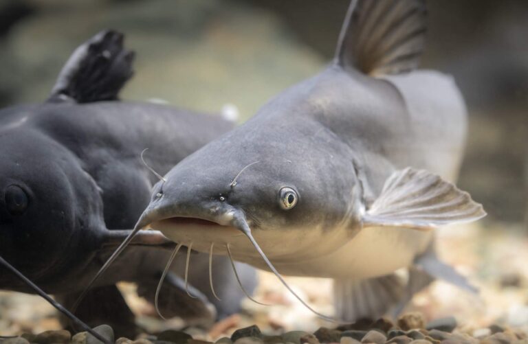
Photo: USFWS Mountain-Prairie, Public domain
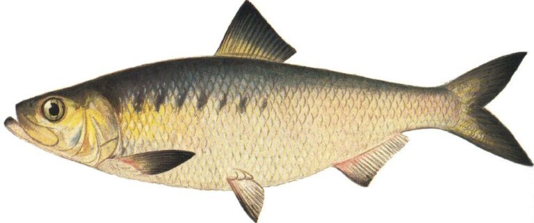
Photo: Ellen Edmonson and Hugh Chrisp, Public domain

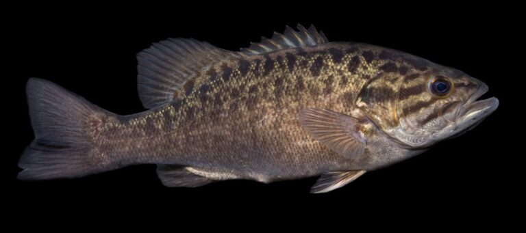
Photo: USFWS Mountain-Prairie, Public domain

Photo: USFWS Mountain-Prairie, Public domain
Straight replies on Tidal Rappahannock River from the Virginia rule books
Which counties or cities touch Tidal Rappahannock River?
It crosses Caroline County and 5 other localities, about 11 miles from Tappahannock.
Which DWR site reaches Tidal Rappahannock River?
DWR maps 9 access sites; Carter's Wharf on Tidal Rappahannock River is one.
What might bite for a Virginia angler in Tidal Rappahannock River?
Look for American shad, blue catfish, channel catfish, hickory shad, largemouth bass, smallmouth bass and striped bass.
Does Tidal Rappahannock River hold DWR trout?
Neither stocked nor wild trout reaches are mapped here.
What bass creel does the digest set for Tidal Rappahannock River?
The statewide digest row for largemouth and smallmouth bass reads: 5 per day in the aggregate (combined); No statewide length limits.
Which Virginia license does Tidal Rappahannock River call for?
A Virginia freshwater license is $23 a year for residents and $47 for nonresidents 16 and older, and a saltwater license is $17.50 for residents and $25 for nonresidents. Kids under 16 fish free.
What is the flow on Tidal Rappahannock River today?
No gauge reads it in our data.
What store sells bait near Tidal Rappahannock River?
S T Marine (about 9 miles away) is first on our list.
Does the Virginia saltwater license come into play on Tidal Rappahannock River?
The digest license line: Rt. 360 Bridge. The fall line landmark: Rt. 1 Bridge.
Pencil in a Virginia weekday on Tidal Rappahannock River
Virginia fees and limits are on one page.