Appomattox River Fishing
A Commonwealth river crossing Appomattox County.
 Pick for troutPiscifun Carbon X ultralight spinning reel28% OFFSale $57.99
Photo of James River: Tony Alter, CC BY 2.0
The essentials of the Appomattox River
This river, the Appomattox River, flows through Appomattox County. The nearest town on the Census list is Hopewell, some 2 miles away.
Discharge and height come from 4 USGS gauges. Near its mouth the river runs tidal.
Virginia DWR waterbody pages, Stocked Trout Reaches and Cold Water Stream Survey layers and Boating Access Locations; USGS gauges; read November 6, 2026.
 For the trout herePiscifun Carbon XT ultralight spinning reel25% OFFSale $59.99
Live discharge along the Appomattox River
| USGS gauge | Latest reading | Time (ET) |
|---|---|---|
| Appomattox River At Farmville, Va | 84 cfs, 4.30 ft gage height | Nov 8 7:20 pm |
| Appomattox River At Mattoax, Va | 105 cfs, 6.86 ft gage height | Nov 8 6:30 pm |
| Appomattox River At Route 602 Near Mannboro, Va | 124 cfs, 2.57 ft gage height | Nov 8 7:00 pm |
US Geological Survey provisional data, retrieved Nov 8, 2026 7:32 pm ET. Provisional readings can be revised.
USGS reviews the Appomattox River values later; read them as provisional.
| USGS site | Name |
|---|---|
| 02039500 | APPOMATTOX RIVER AT FARMVILLE, VA |
| 02040000 | APPOMATTOX RIVER AT MATTOAX, VA |
| 02040892 | APPOMATTOX RIVER AT ROUTE 602 NEAR MANNBORO, VA |
| 02041650 | APPOMATTOX RIVER AT MATOACA, VA |
USGS instantaneous values, provisional.
Species DWR lists for the Appomattox River
DWR labels alone drive the Appomattox River list.
Virginia DWR waterbody page (updated 11/17/2023), read November 6, 2026.
Put-ins and take-outs on the Appomattox River
You will not find Appomattox River on the DWR boating access list.
Fallback Commonwealth launches near Appomattox River
- White Bank Park on Swift Creek LakeSwift Creek Lake, 6 miles southwest
- Deep Bottom boat ramp on Tidal James RiverTidal James River, 6 miles north
- Dutch Gap boat ramp on Tidal James RiverTidal James River, 7 miles northwest
- Osborne boat ramp on Tidal James RiverTidal James River, 8 miles northwest
- Wilcox Lake boat rampWilcox Lake, 11 miles southwest
Virginia DWR Boating Access Locations layer (attributes as recorded; lanes, fees and hours are not in the layer), read November 6, 2026.
Tidewater miles of the Appomattox River
- Mouth (GNIS)Chesterfield County
- Fall line landmark (digest)The remnants of Harvell Dam approx. 0.5 mi upstream of Rt. 1
- NoteTidal reach and saltwater-license boundary per VMRC/DWR, not given by GNIS.
The digest names a fall line landmark on Appomattox River; anadromous striped bass rules change there.
| Species | Area | Size | Bag | Season | VAC section |
|---|---|---|---|---|---|
| Black drum | Virginia tidal waters | 16 in minimum | 1 | not stated | 4VAC20-320-40 |
| Bluefish | Virginia tidal waters | not stated | 5 | not stated | 4VAC20-450-20 |
| Cobia | Virginia tidal waters | 43 in minimum | 1 | June 15 through September 20 | 4VAC20-510-20 |
| Grey trout (weakfish) | Virginia tidal waters | 12 in minimum | 1 | not stated | 4VAC20-380-60 |
| Spanish mackerel | Virginia tidal waters | 14 in minimum | 15 | not stated | 4VAC20-540-30 |
| Summer flounder | Tidal waters except Potomac River tributaries | 16 in minimum | 4 | Open year-round (January 1 through May 31 size) | 4VAC20-620-50 |
| Summer flounder | Tidal waters except Potomac River tributaries | 17.5 in minimum | 4 | Open year-round (June 1 through December 31 size) | 4VAC20-620-50 |
Rules as printed, 2026 Freshwater Fishing in Virginia digest (eRegulations, linked from the Virginia DWR regulations page), read November 6, 2026. Virginia Administrative Code, Title 4 Agency 20 (Marine Resources Commission) on law.lis.virginia.gov, as of November 6, 2026 (VMRC rules change by emergency order; check the VMRC regulations page before keeping fish).
Keep rules for the Appomattox River
| Species as printed | Applies to | Creel | Length |
|---|---|---|---|
| Largemouth, Smallmouth Bass | statewide | 5 per day in the aggregate (combined) | No statewide length limits |
| Alabama, Spotted Bass | statewide | No statewide daily limit | No statewide length limit |
| Landlocked Striped Bass and Landlocked Striped Bass X White Bass Hybrids | statewide | 4 per day in the aggregate | No fish less than 20 inches |
| Striped Bass | Anadromous (coastal) striped bass above the fall line in all coastal rivers of the Chesapeake Bay and Crane Lake (City of Suffolk) | Creel and length limits shall be as set by the Virginia Marine Resources Commission for recreational fishing in tidal waters | no length limit printed |
| Striped Bass | Striped bass in the Meherrin, Nottoway, Blackwater (Chowan Drainage), North Landing and Northwest rivers and their tributaries plus Back Bay | No possession | no length limit printed |
| Walleye, Saugeye | statewide | 5 per day in the aggregate | No walleye or saugeye less than 18 inches |
| Sauger | statewide | 2 per day | No statewide length limits |
| White Bass | statewide | 5 per day | No statewide length limits |
| Chain Pickerel and Northern Pike | statewide | 5 per day | No statewide length limits |
| Muskellunge | statewide | 1 per day | No muskellunge less than 40 inches |
| Bluegill (bream) and other sunfish excluding Crappie, Rock Bass (redeye) and Roanoke Bass | statewide | 50 per day in the aggregate (combined) | No statewide length limits |
| Crappie (black or white) | statewide | 25 per day in the aggregate (combined) | No statewide length limits |
| Rock Bass (redeye) | statewide | 25 per day in the aggregate with Roanoke bass | No statewide length limits |
| Roanoke Bass | statewide | 25 per day in the aggregate with rock bass | No statewide length limits |
| Perch (yellow and white) | statewide | No statewide daily limit | No statewide length limit |
| Trout | statewide | 6 per day | 7 inch minimum size |
| Channel, White, and Flathead | statewide | 20 per day | No length limits |
| Blue | statewide | 20 per day | No statewide length limits |
For Appomattox River, the statewide digest is the starting point.
A Virginia freshwater license is $23 a year for residents and $47 for nonresidents 16 and older, and a saltwater license is $17.50 for residents and $25 for nonresidents.
Statewide creel and length limits as printed (page updated August 17, 2026), 2026 Freshwater Fishing in Virginia digest (eRegulations, linked from the Virginia DWR regulations page), read November 6, 2026. Virginia license fees in the 2026 Freshwater Fishing in Virginia digest (licenses run one year from purchase unless noted), read November 6, 2026.
Lining up the Appomattox River with nearby rivers
| Stream | Distance | DWR access sites | USGS gauges | Stocked reaches |
|---|---|---|---|---|
| Appomattox River | this stream | 0 | 4 | 0 |
| Chickahominy River | 22 miles east | 0 | 2 | 0 |
| Nottoway River | 32 miles south | 6 | 5 | 0 |
| Pamunkey River | 33 miles north | 2 | 2 | 0 |
| Tidal James River | 35 miles east | 6 | 0 | 0 |
| Blackwater River | 42 miles southeast | 3 | 5 | 0 |
Virginia DWR Boating Access Locations and Stocked Trout Reaches, USGS gauges; read November 6, 2026.
Neighbouring stops for Appomattox River
Nearby lakes worth a cast after Appomattox River
- Harrison Lake5 miles
- Lakeview Reservoir9 miles
- Dorey Park Lake10 miles
- Wilcox Lake11 miles
Commonwealth tackle shops serving Appomattox River
- Fish Tales 2bait and tackle shop, Hopewell, 1 mile
- Fish Tales & Bait Tacklebait and tackle shop, Hopewell, 2 miles
- James River Tackle Cobait and tackle shop, Hopewell, 2 miles
- Appomattox Boat Harbormarina, Prince George, 7 miles
- Fin and Skin Taxidermy & Bait Shopbait and tackle shop, Henrico, 10 miles
- Brenda's Bait & Tackle Shopbait and tackle shop, Petersburg, 10 miles
Where anglers bunk when fishing Appomattox River
- Hopewell2 miles, City of Hopewell
- Enon3 miles, Chesterfield County
- Fort Lee7 miles, Prince George County
Appomattox River, broken out by Virginia locality
- Appomattox Countycounty seat Appomattox
Rivers one drainage over from the Appomattox River
- Chickahominy River22 miles
- Nottoway River32 miles
- Pamunkey River33 miles
- Tidal James River35 miles
- Blackwater River42 miles
Piscifun reels for a Virginia day on Appomattox River


Piscifun and Amazon links are affiliate links; the site earns a commission on qualifying purchases.
Sorting out the Appomattox River species by sight
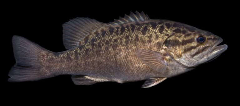
Photo: USFWS Mountain-Prairie, Public domain
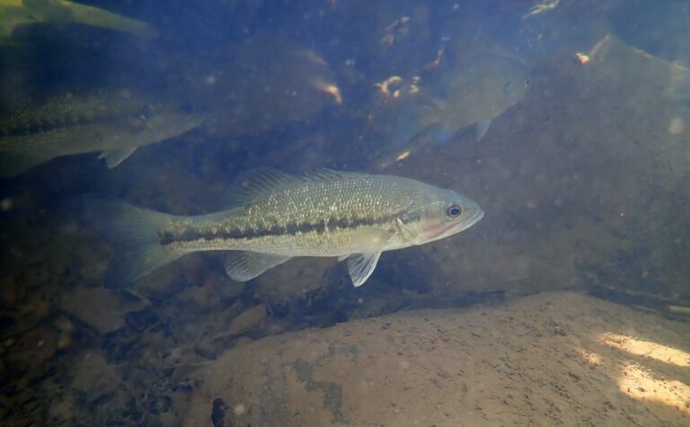
Photo: schizoform, CC BY 2.0
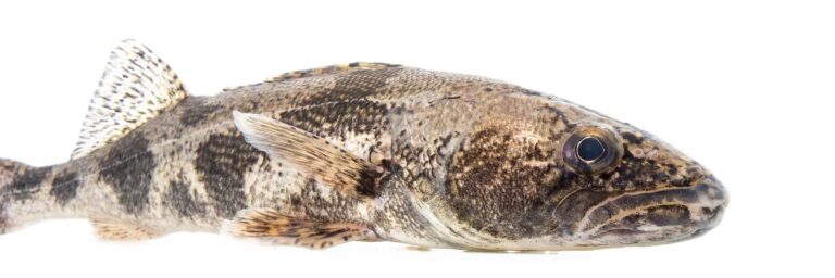
Photo: USFWS Mountain-Prairie, Public domain
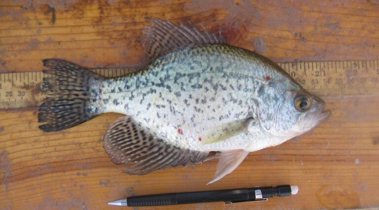
Photo: USFWS Mountain-Prairie, Public domain
The Appomattox River: what Old Dominion anglers keep asking
Which counties or cities touch the Appomattox River?
It crosses Appomattox County, about 2 miles from Hopewell.
Which DWR site reaches the Appomattox River?
None on it; the closest DWR site is White Bank Park on Swift Creek Lake, about 6 miles away.
What might bite for a Virginia angler in the Appomattox River?
Look for American shad, bluegill, crappie, redbreast sunfish, smallmouth bass, spotted bass and striped bass.
Does the Appomattox River hold DWR trout?
Neither stocked nor wild trout reaches are mapped here.
What bass creel does the digest set for the Appomattox River?
The statewide digest row for largemouth and smallmouth bass reads: 5 per day in the aggregate (combined); No statewide length limits.
Which Virginia license does the Appomattox River call for?
A Virginia freshwater license is $23 a year for residents and $47 for nonresidents 16 and older, and a saltwater license is $17.50 for residents and $25 for nonresidents. Kids under 16 fish free.
What is the flow on the Appomattox River today?
The flow band carries 4 USGS gauges.
What store sells bait near the Appomattox River?
Fish Tales 2 (about 1 mile away) is first on our list.
Does the Virginia saltwater license come into play on the Appomattox River?
The fall line landmark: The remnants of Harvell Dam approx. 0.5 mi upstream of Rt. 1.
Pencil in a Virginia weekday on the Appomattox River
Virginia fees and limits are on one page.