Fishing in City of Chesapeake, Virginia
Independent city; 249,422 residents at the 2020 Census.
- 2lake pages
- 1DWR launches
 Pick for troutPiscifun Carbon X ultralight spinning reel28% OFFSale $57.99
Photo of Portsmouth: Doug Kerr, CC BY-SA 2.0
City of Chesapeake fishing at a glance
One of 38 independent Virginia cities, City of Chesapeake numbered 249,422 residents in the 2020 count. Local DWR records show DWR Region 1. Tidal water reaches it: 2 coast pages and 1 saltwater launch sit on the salt side.
The 2 paged lakes here are headed, by size, by Lake Drummond. A trailer can go in at 1 boating access site here, per DWR records. Without a boat, 5 fishing piers are on the DWR list. Its water appears in 10 stocking dates of the DWR trout schedule.
Census 2020 population; Virginia DWR Public Fishing Lakes layer (outline, motor rule, region number), read November 6, 2026. Virginia DWR Boating Access Locations layer (attributes as recorded; lanes, fees and hours are not in the layer), read November 6, 2026. Virginia DWR trout stocking schedule (date, county, water, category and species as listed; DWR prints no numbers or sizes), read November 6, 2026.
 For the trout herePiscifun Carbon XT ultralight spinning reel25% OFFSale $59.99
Where the ramps and lakes of City of Chesapeake sit
Virginia DWR Boating Access Locations layer (attributes as recorded; lanes, fees and hours are not in the layer), read November 6, 2026. Lake points from the Virginia DWR Public Fishing Lakes layer (outline, motor rule, region number), read November 6, 2026.
Reservoirs and ponds within City of Chesapeake
| Lake | Area | Kind | DWR launches | Fish DWR names |
|---|---|---|---|---|
| Lake Drummond | 3,142 acres | lake | 0 | bowfin, bullhead, chain pickerel |
| Northwest River Park Lake | 0 acres (DWR outline area) | lake | 0 | bluegill, channel catfish, crappie |
From Chesapeake, the lakes below lie outside City of Chesapeake.
| Lake | From Chesapeake | Area | Kind | DWR launches | Fish DWR names |
|---|---|---|---|---|---|
| Trashmore Lake | 14 miles northeast | 52 acres | lake | 0 | common carp, largemouth bass, white perch |
| Lake Whitehurst | 17 miles north | 838 acres (DWR outline area) | lake | 0 | |
| Lake Meade | 17 miles west | 512 acres | lake | 0 | bluegill, crappie, largemouth bass |
| Lake Kilby | 17 miles west | 222 acres | lake | 0 | black crappie, bluegill, chain pickerel |
| Western Branch Reservoir | 19 miles northwest | 1,265 acres | reservoir | 0 | crappie, largemouth bass, muskellunge |
| Speight’s Run | 19 miles west | 197 acres | lake | 0 | bluegill, crappie, largemouth bass |
Acres are the NHD outline area of the mapped lake (USGS National Hydrography Dataset), not a DWR figure. Virginia DWR Boating Access Locations layer (attributes as recorded; lanes, fees and hours are not in the layer), read November 6, 2026.
Saltwater launches and coast pages for City of Chesapeake
The Chesapeake Bay page gathers the bay-wide saltwater rows; the tidal water of this locality follows.
- Eastern Branch Elizabeth Rivertidal river, bay side
- Southern Branch Elizabeth Rivertidal river, bay side
City of Chesapeake ramps onto tidal water
- Elizabeth River boat ramp on Southern Branch Elizabeth RiverSouthern Branch Elizabeth River, dock and ramp, 4 ramps, barrier-free, saltwater
USGS GNIS names and points for bays, inlets and tidal rivers; Virginia DWR Boating Access Locations layer (attributes as recorded; lanes, fees and hours are not in the layer), read November 6, 2026.
Lake-page species counts for City of Chesapeake
Within 50 miles of Chesapeake, DWR lists largemouth bass on more lake pages than any other fish.
Species DWR names on waterbody pages and its fishing grid, counted per lake page within 50 miles; not a survey of fish numbers.
Streams that cross City of Chesapeake
Gauge readings flowing in from City of Chesapeake
| USGS gauge | Latest reading | Time (ET) |
|---|---|---|
| Conveyance Chan At Ramsgate Ln Nr Great Bridge, Va | 0 cfs, 0.10 ft gage height | Nov 7 8:40 am Not updated since Nov 7, 2026. |
US Geological Survey provisional data, retrieved Nov 12, 2026 8:32 pm ET. Provisional readings can be revised.
DWR waterbody pages, DWR Stocked Trout Reaches and Cold Water Stream Survey layers (wild trout classes and kilometres as recorded), DWR launches and USGS gauges (live readings); read November 6, 2026.
Recorded launches in City of Chesapeake
- Elizabeth River boat ramp on Southern Branch Elizabeth RiverSouthern Branch Elizabeth River, dock and ramp, 4 ramps, barrier-free, saltwater
Decks for City of Chesapeake anglers without a boat
- Oak Grove Lake ParkOak Grove Lake, fishing pier
- Oak Grove Lake ParkOak Grove Lake, fishing pier
- Oak Grove Lake ParkOak Grove Lake, fishing pier
- Oak Grove Lake Park (east)Oak Grove Lake, fishing pier
- Oak Grove Lake Park (west)Oak Grove Lake, fishing pier
Virginia DWR Boating Access Locations layer (attributes as recorded; lanes, fees and hours are not in the layer), read November 6, 2026. Virginia DWR Fishing Piers layer (name and water only), read November 6, 2026.
Catchable trout releases across City of Chesapeake
| Date | Water as listed | Category | Species |
|---|---|---|---|
| March 22, 2024 | Northwest River Park | U | Rainbow Trout, Brown Trout |
| February 15, 2024 | Northwest River Park | U | Rainbow Trout |
| January 24, 2024 | Northwest River Park | U | Rainbow Trout, Brown Trout |
| January 2, 2024 | Northwest River Park | U | Rainbow Trout, Brown Trout |
| December 20, 2023 | Northwest River Park | U | Rainbow Trout, Brown Trout |
| March 28, 2023 | Northwest River Park | U | Rainbow Trout, Brown Trout |
| March 16, 2023 | Northwest River Park | U | Brown Trout, Brook Trout |
| March 3, 2023 | Northwest River Park | U | Rainbow Trout, Brown Trout |
| February 15, 2023 | Northwest River Park | U | Rainbow Trout |
| February 6, 2023 | Northwest River Park | U | Rainbow Trout, Brown Trout |
City of Chesapeake on the 2026 catchable trout plan
| Water | County or city as printed | Category | Category meaning | National forest |
|---|---|---|---|---|
| Northwest River Park | Chesapeake City | U | urban fishing waters, trout license required November 1 through April 30, stocked 5 times between November 1 and April 15 |
Virginia DWR trout stocking schedule (date, county, water, category and species as listed; DWR prints no numbers or sizes), read November 6, 2026 2026 Catchable Trout Stocking Plan (category letters as printed), read November 6, 2026. Designated stocked trout waters require a trout license October 1 to June 15; urban waters November 1 to April 30 (as printed).
What a stringer may hold in City of Chesapeake
Statewide rows hold across City of Chesapeake; named exceptions follow the table. Virginians 16 and older pay $23 for a year of freshwater fishing; visitors from other states pay $47. Bay and tidal river trips add a saltwater license at $17.50 for residents and $25 for visitors.
| Species | Where it applies | Creel | Length |
|---|---|---|---|
| Largemouth, Smallmouth Bass | statewide | 5 per day in the aggregate (combined) | No statewide length limits |
| Alabama, Spotted Bass | statewide | No statewide daily limit | No statewide length limit |
| Landlocked Striped Bass and Landlocked Striped Bass X White Bass Hybrids | statewide | 4 per day in the aggregate | No fish less than 20 inches |
| Striped Bass | Anadromous (coastal) striped bass above the fall line in all coastal rivers of the Chesapeake Bay and Crane Lake (City of Suffolk) | Creel and length limits shall be as set by the Virginia Marine Resources Commission for recreational fishing in tidal waters | no length limit printed |
| Striped Bass | Striped bass in the Meherrin, Nottoway, Blackwater (Chowan Drainage), North Landing and Northwest rivers and their tributaries plus Back Bay | No possession | no length limit printed |
| Walleye, Saugeye | statewide | 5 per day in the aggregate | No walleye or saugeye less than 18 inches |
| Sauger | statewide | 2 per day | No statewide length limits |
| White Bass | statewide | 5 per day | No statewide length limits |
| Chain Pickerel and Northern Pike | statewide | 5 per day | No statewide length limits |
| Muskellunge | statewide | 1 per day | No muskellunge less than 40 inches |
| Bluegill (bream) and other sunfish excluding Crappie, Rock Bass (redeye) and Roanoke Bass | statewide | 50 per day in the aggregate (combined) | No statewide length limits |
| Crappie (black or white) | statewide | 25 per day in the aggregate (combined) | No statewide length limits |
| Rock Bass (redeye) | statewide | 25 per day in the aggregate with Roanoke bass | No statewide length limits |
| Roanoke Bass | statewide | 25 per day in the aggregate with rock bass | No statewide length limits |
| Perch (yellow and white) | statewide | No statewide daily limit | No statewide length limit |
| Trout | statewide | 6 per day | 7 inch minimum size |
| Channel, White, and Flathead | statewide | 20 per day | No length limits |
| Blue | statewide | 20 per day | No statewide length limits |
| Hickory Shad | Above and below the fall line in all coastal rivers of the Chesapeake Bay and their tributaries | Creel and length limits shall be the same as those set by the Virginia Marine Resources Comm. in tidal rivers | no length limit printed |
| Hickory Shad | Meherrin River below Emporia Dam, Nottoway River, Blackwater River (Chowan Drainage), North Landing and Northwest rivers, and their tributaries plus Back Bay | 10 per day | No length limits |
| Anadromous (coastal) Alewife and Blueback Herring | Above and below the fall line in all coastal rivers of the Chesapeake Bay and their tributaries | Creel and length limits shall be the same as those set by the Virginia Marine Resources Comm. for these species in tidal rivers | no length limit printed |
| Other native or naturalized nongame fish | statewide | 20 per day | No length limits |
| Threatened and endangered species | statewide | No possession | no length limit printed |
| Grass Carp | statewide | No statewide daily limit | No statewide length limit |
| Longnose Gar | statewide | July 1 to April 14: 5 per day | April 15 to June 30: 1 per day No statewide length limits |
| Bowfin | statewide | July 1 to April 14: 5 per day | April 15 to June 30: 1 per day No statewide length limits |
| Northern Snakehead | statewide | No statewide daily limit | No statewide length limit |
| Spotted Sea Trout | Back Bay and tributaries, including Brinson’s Inlet Lake (Lake Tecumseh), and the North Landing River and its tributaries | 4 per day, no fish less than 14 inches | no length limit printed |
| Red Drum | Back Bay and tributaries, including Brinson’s Inlet Lake (Lake Tecumseh), and the North Landing River and its tributaries | 1 per day between 18 and 27 inches | no length limit printed |
| Grey Trout | Back Bay and tributaries, including Brinson’s Inlet Lake (Lake Tecumseh), and the North Landing River and its tributaries | 1 per day, no fish less than 12 inches | no length limit printed |
Saltwater rows for City of Chesapeake anglers
| Species | Area | Size | Bag | Season | VAC section |
|---|---|---|---|---|---|
| Striped bass | Chesapeake Bay and its tributaries (spring/summer) | 19 in minimum, 24 in maximum | 1 | May 16 through June 15 | 4VAC20-252-80 |
| Striped bass | Chesapeake Bay and its tributaries (fall) | 19 in minimum, 24 in maximum | 1 | October 4 through December 31 | 4VAC20-252-90 |
| Striped bass | Potomac River tributaries | 19 in minimum, 24 in maximum | 1 | May 16 through July 6 and August 21 through December 31 | 4VAC20-252-100 |
| Striped bass | Coastal area | 28 in minimum, 31 in maximum | 1 | January 1 through March 31 and May 16 through December 31 | 4VAC20-252-110 |
| Striped bass | All Virginia waters | not stated | not stated | not stated | 4VAC20-252-50 |
| Speckled trout | Virginia tidal waters | 14 in minimum | 5 | Closed April 1, 2026 through June 30, 2026 | 4VAC20-280-30 |
| Black drum | Virginia tidal waters | 16 in minimum | 1 | not stated | 4VAC20-320-40 |
| Grey trout (weakfish) | Virginia tidal waters | 12 in minimum | 1 | not stated | 4VAC20-380-60 |
| Bluefish | Virginia tidal waters | not stated | 5 | not stated | 4VAC20-450-20 |
| Sharks (recreationally permitted) | Vessel: one per trip per vessel; shore angler: one per calendar day | 54 in minimum | 1 | not stated | 4VAC20-490-40 |
| Cobia | Virginia tidal waters | 43 in minimum | 1 | June 15 through September 20 | 4VAC20-510-20 |
| Amberjack | Virginia tidal waters | 32 in minimum | 2 | not stated | 4VAC20-510-20 |
| Spanish mackerel | Virginia tidal waters | 14 in minimum | 15 | not stated | 4VAC20-540-30 |
| King mackerel | Virginia tidal waters | 27 in minimum | 3 | not stated | 4VAC20-540-30 |
Statewide creel and length limits as printed (page updated August 17, 2026), 2026 Freshwater Fishing in Virginia digest (eRegulations, linked from the Virginia DWR regulations page), read November 6, 2026. Virginia Administrative Code, Title 4 Agency 20 (Marine Resources Commission) on law.lis.virginia.gov, as of November 6, 2026 (VMRC rules change by emergency order; check the VMRC regulations page before keeping fish). Virginia license fees in the 2026 Freshwater Fishing in Virginia digest (licenses run one year from purchase unless noted), read November 6, 2026.
The record list as it touches City of Chesapeake
No state record on the DWR list traces to water in City of Chesapeake, so record waters within 70 miles are shown.
| Species | Weight as printed | Water | Year |
|---|---|---|---|
| White Catfish | 7 lbs. 6 oz. | Western Branch Reservoir | 1992 |
| Common Carp | 49 lbs. 4 oz. | Lake Prince | 1986 |
| Gar | 25 lbs. 2 oz. | Lake Prince | 1987 |
| Bowfin | 10 lbs. 12 oz. | Chickahominy River | 2016 |
State Record Freshwater Fish as of 9-2-2025 (keeper: Virginia DWR (State Record Freshwater Fish list as of 9-2-2025); angler names left off here), read November 6, 2026.
Marinas, tackle and captains of City of Chesapeake
Shops listed for City of Chesapeake
- Bob's Fishing Holebait and tackle shop, Chesapeake
- Chesapeake Bait & Tacklebait and tackle shop, Chesapeake
- Gail's Bait & Tacklebait and tackle shop, Chesapeake
- Centerville Waterway Marinamarina, Chesapeake
- Top Rack Marina, 5532 Bainbridge Blvdmarina, Chesapeake
- Top Rack Marina, 749 Green Tree Cirmarina, Chesapeake
Yellow Pages and chain store listings; guide and charter business listings (matched by the waters they list or their locality), read November 6, 2026.
Close by City of Chesapeake
City of Chesapeake town pages
- Chesapeakepop. 249,422
Bordering localities of City of Chesapeake
- City of Portsmouth13 miles north
- City of Virginia Beach17 miles northeast
- City of Norfolk17 miles north
- City of Suffolk18 miles west
Piscifun reels for a Virginia day on City of Chesapeake


Piscifun and Amazon links are affiliate links; the site earns a commission on qualifying purchases.
Sorting out the City of Chesapeake species by sight
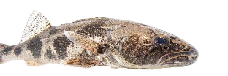
Photo: USFWS Mountain-Prairie, Public domain

Photo: USFWS Mountain-Prairie, Public domain
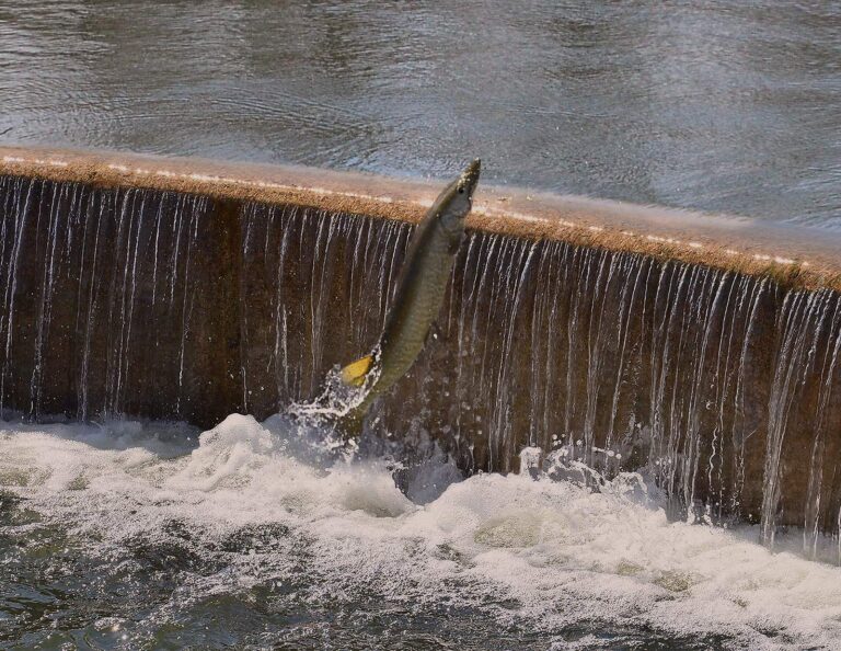
Photo: Richard Hurd, CC BY 2.0
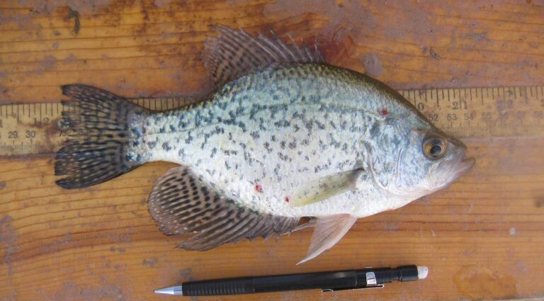
Photo: USFWS Mountain-Prairie, Public domain
Questions on water across City of Chesapeake
Where does a bass boat go in within City of Chesapeake?
DWR counts 1 boating access site; Elizabeth River boat ramp on Southern Branch Elizabeth River is one of them.
Which paged lake in City of Chesapeake covers the most acres?
Lake Drummond, at 3,142 acres.
What might a visiting angler target around City of Chesapeake?
Largemouth bass leads the count of lake pages within 50 miles, then crappie, bluegill and redear sunfish; DWR names them on its waterbody pages.
Does a Yellow Pages bait listing fall inside City of Chesapeake?
Bob's Fishing Hole heads a local list of 6.
How many people live in City of Chesapeake?
249,422 residents in 2020.
What license does fishing in City of Chesapeake call for?
Virginians 16 and older pay $23 for a year of freshwater fishing; visitors from other states pay $47. Bay and tidal river trips add a saltwater license at $17.50 for residents and $25 for visitors.
Which localities lie just past City of Chesapeake?
Measured centre to centre, City of Portsmouth, City of Virginia Beach and City of Norfolk are nearest.
What region number do DWR points in City of Chesapeake carry?
DWR lakes, ramps or piers inside it carry the number for DWR Region 1.
Is a DWR fishing pier open to the public in City of Chesapeake?
5 fishing piers appear on the DWR layer, Oak Grove Lake Park among them.
Has DWR released trout into water of City of Chesapeake?
The DWR schedule carries 10 stocking dates; the newest lists Rainbow Trout, Brown Trout (March 22, 2024; category U) at Northwest River Park.
Does City of Chesapeake have brackish-water access?
Tidal water reaches it: 2 coast pages and 1 saltwater launch sit on the salt side.
Give a Saturday to the water of City of Chesapeake
Lake pages carry launches, DWR notes and digest exceptions.