Southern Branch Elizabeth River Fishing
A tidal river in City of Chesapeake, on the Chesapeake Bay side.
 Pick for troutPiscifun Carbon X ultralight spinning reel28% OFFSale $57.99
Photo of Portsmouth: Doug Kerr, CC BY-SA 2.0
Southern Branch Elizabeth River, the short version
USGS records Southern Branch Elizabeth River as a tidal river on the Chesapeake Bay side within City of Chesapeake. Portsmouth sits some 4 miles from the named point.
DWR records 1 saltwater launch opening onto it. 4 artificial reefs from the VMRC reef charts lie within 25 miles. NOAA keeps 3 water-level stations within 25 miles. Its tidal water follows the VMRC saltwater limits.
USGS GNIS named feature 1480082; Virginia DWR Boating Access Locations; NOAA CO-OPS; read November 6, 2026.
Getting a boat onto Southern Branch Elizabeth River
| Site | Recorded attributes | Owner | Location (DWR) |
|---|---|---|---|
| Elizabeth River boat ramp on Southern Branch Elizabeth River | dock and ramp, 4 ramps, barrier-free, saltwater | Chesapeake | City of Chesapeake, Rt 337 |
Virginia DWR Boating Access Locations layer (attributes as recorded; lanes, fees and hours are not in the layer), read November 6, 2026.
Marine creel limits on Southern Branch Elizabeth River
| Species | Area | Size | Bag | Season | VAC section |
|---|---|---|---|---|---|
| Black drum | Virginia tidal waters | 16 in minimum | 1 | not stated | 4VAC20-320-40 |
| Bluefish | Virginia tidal waters | not stated | 5 | not stated | 4VAC20-450-20 |
| Cobia | Virginia tidal waters | 43 in minimum | 1 | June 15 through September 20 | 4VAC20-510-20 |
| Grey trout (weakfish) | Virginia tidal waters | 12 in minimum | 1 | not stated | 4VAC20-380-60 |
| Spanish mackerel | Virginia tidal waters | 14 in minimum | 15 | not stated | 4VAC20-540-30 |
| Speckled trout | Virginia tidal waters | 14 in minimum | 5 | Closed April 1, 2026 through June 30, 2026 | 4VAC20-280-30 |
| Striped bass | All Virginia waters | not stated | not stated | not stated | 4VAC20-252-50 |
| Summer flounder | Tidal waters except Potomac River tributaries | 16 in minimum | 4 | Open year-round (January 1 through May 31 size) | 4VAC20-620-50 |
The Marine Resources Commission rules shown for Southern Branch Elizabeth River date from November 6, 2026.
Virginia Administrative Code, Title 4 Agency 20 (Marine Resources Commission) on law.lis.virginia.gov, as of November 6, 2026 (VMRC rules change by emergency order; check the VMRC regulations page before keeping fish).
License line on Southern Branch Elizabeth River
- Freshwater/saltwater license line (digest)The Great Bridge Locks
A Virginia freshwater license is $23 a year for residents and $47 for nonresidents 16 and older, and a saltwater license is $17.50 for residents and $25 for nonresidents.
Virginia license fees in the 2026 Freshwater Fishing in Virginia digest (licenses run one year from purchase unless noted), read November 6, 2026. Virginia Marine Resources Commission license fees, read November 6, 2026.
 For the trout herePiscifun Carbon XT ultralight spinning reel25% OFFSale $59.99
Tide prediction points near Southern Branch Elizabeth River
| NOAA water-level station | ID | Distance |
|---|---|---|
| Money Point | 8639348 | 4 miles |
| Sewells Point | 8638610 | 7 miles |
| CBBT, Chesapeake Channel | 8638901 | 18 miles |
Prediction stations for Southern Branch Elizabeth River
| Prediction station | Distance |
|---|---|
| Norfolk | under a mile |
| Portsmouth, Naval Shipyard | 1 mile |
| Lafayette River | 3 miles |
| Craney Island Light | 4 miles |
| Money Point | 4 miles |
| Western Branch | 6 miles |
Readings for Southern Branch Elizabeth River stay on NOAA pages.
NOAA CO-OPS Tides & Currents station list, read November 6, 2026.
Artificial reefs off Southern Branch Elizabeth River
| Reef | Area | Distance | Clearance (ft, MLW) |
|---|---|---|---|
| East Oceanview Artificial Reef | Chesapeake Bay | 9 miles | |
| Middle Ground Artificial Reef | Chesapeake Bay | 9 miles | 12 |
| Bluefish Rock Artificial Reef | Chesapeake Bay | 15 miles | 15 |
| Back River Artificial Reef | Chesapeake Bay | 21 miles | 15 |
VMRC guide charts supply the reefs listed for Southern Branch Elizabeth River.
Virginia Marine Resources Commission saltwater angler guide reef charts, read November 7, 2026.
Fishing villages around Southern Branch Elizabeth River
Communities near Southern Branch Elizabeth River
- NorfolkNorfolk (city), under a mile
- HamptonHampton (city), 13 miles
Virginia Marine Resources Commission saltwater angler guide (c. 2008, names only); USGS GNIS populated places.
Just off Southern Branch Elizabeth River, by road
Coast water within reach of Southern Branch Elizabeth River
- Eastern Branch Elizabeth Rivertidal river, under a mile
- Western Branch Elizabeth Rivertidal river, 3 miles
- Lafayette Rivertidal river, 4 miles
- Elizabeth Rivertidal river, 6 miles
- Willoughby Baybay, 8 miles
Beyond the mouth of Southern Branch Elizabeth River
- Chesapeake BayVirginia side
Fresh water inland from Southern Branch Elizabeth River
- Tidal James River29 miles
- Lake Whitehurst7 miles
- Trashmore Lake9 miles
- Lake Biggins15 miles
Filling the bait bucket close to Southern Branch Elizabeth River
- Tidewater Yacht Marinamarina, Portsmouth, under a mile
- Ocean Yacht Marinamarina, Portsmouth, under a mile
- Marina Owensmarina, Norfolk, under a mile
- Portsmouth Boating Centermarina, Portsmouth, 1 mile
- Scott's Creek Marina Incmarina, Portsmouth, 1 mile
- Shipwright Marinamarina, Portsmouth, 3 miles
Places to stay near Southern Branch Elizabeth River
- Portsmouth4 miles, City of Portsmouth
- Norfolk6 miles, City of Norfolk
- Chesapeake11 miles, City of Chesapeake
- Hampton14 miles, City of Hampton
The Virginia counties and cities along Southern Branch Elizabeth River
- City of Chesapeakeindependent city
Reels from Piscifun for the next trip to Southern Branch Elizabeth River


Piscifun and Amazon links are affiliate links; the site earns a commission on qualifying purchases.
Lakes, tidewater and stream riffles close to Southern Branch Elizabeth River, in pictures
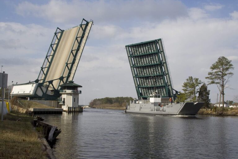
Photo: U.S. Army Corps of Engineers Norfolk District, CC BY 2.0

Photo: Doug Kerr, CC BY-SA 2.0

Photo: Doug Lewis, CC BY 2.0

Photo: Missy Schmidt, CC BY 2.0
Southern Branch Elizabeth River, asked and answered for Virginia anglers
How does a Virginia chart or map label Southern Branch Elizabeth River?
It is in City of Chesapeake, on the Chesapeake Bay side, about 4 miles from Portsmouth.
Does DWR list a tidal launch close to Southern Branch Elizabeth River?
Start at Elizabeth River boat ramp on Southern Branch Elizabeth River, one of 1 saltwater launch.
Does Southern Branch Elizabeth River call for the Virginia saltwater license?
A Virginia saltwater license is $17.50 for residents and $25 for nonresidents 16 and older. The digest license line here: The Great Bridge Locks. Youth under 16 fish free.
Can I keep a big red drum from Southern Branch Elizabeth River?
Red drum: 3 a day, 18-inch minimum, 26-inch maximum (4VAC20-1400-30), as of November 6, 2026.
Which speckled trout rule covers Southern Branch Elizabeth River?
Speckled trout: 5 a day, 14-inch minimum (4VAC20-280-30); the code closes the season April 1 through June 30, 2026, as of November 6, 2026.
Which flounder rule covers Southern Branch Elizabeth River?
Summer flounder: 4 a day, 16-inch minimum (4VAC20-620-50); the minimum rises June 1 per the code section, as of November 6, 2026.
Which tide table fits Southern Branch Elizabeth River?
The tide table for Norfolk, under a mile off, fits best.
What tackle store is handiest for Southern Branch Elizabeth River trips?
Tidewater Yacht Marina (under a mile away) heads the list.
Do VMRC reef sites lie within reach of Southern Branch Elizabeth River?
East Oceanview Artificial Reef is the closest VMRC guide reef, about 9 miles away (chart-grid midpoint, not a structure position).
Catch the tide on Southern Branch Elizabeth River
Licenses and code limits are on the regulations page.