Mossy Creek Fishing
Virginia creek fishing in Augusta County.
 Pick for troutPiscifun Carbon X ultralight spinning reel28% OFFSale $57.99
Photo, nearby stand in for Mossy Creek: Doug Kerr, CC BY-SA 2.0
Mossy Creek, the short version
In Augusta County you meet Mossy Creek, a creek on the Virginia map. Supplies are nearest in Bridgewater, around 5 miles off.
DWR lists 1 stocked reach for trout stocking. The survey layer gives 10.9 km of wild trout reaches. The digest lists it among special regulation trout waters.
Virginia DWR waterbody pages, Stocked Trout Reaches and Cold Water Stream Survey layers and Boating Access Locations; USGS gauges; read November 6, 2026.
 For the trout herePiscifun Carbon XT ultralight spinning reel25% OFFSale $59.99
The DWR waterbody page on Mossy Creek
Mossy Creek is Virginia’s most famous fly fishing destination. Flowing through rolling farmland, it is a classic limestone creek that features tough-to-catch brown trout, undulating masses of aquatic vegetation, swift runs, and steep drop-offs. It is especially challenging to beginning fly anglers, and can even frustrate experienced fishermen. Since no wading is allowed, fish must be approached cautiously from steep banks.
The DWR page supplies the quoted lines on Mossy Creek.
Virginia DWR waterbody page (updated 11/17/2023), read November 6, 2026.
What swims in Mossy Creek, per DWR
No survey or catch data went into the Mossy Creek list beyond DWR labels.
Virginia DWR waterbody page (updated 11/17/2023), read November 6, 2026. Virginia DWR Cold Water Stream Survey trout streams (reach class I to IV, length, species present), read November 6, 2026.
Boat ramps serving Mossy Creek
The DWR access layer has nothing on Mossy Creek; wade in only where access is public.
Ramps worth knowing close to Mossy Creek
- Lake Shenandoah boat rampLake Shenandoah, 11 miles east
- Grottoes Park on South RiverSouth River, 12 miles southeast
- Port Republic boat ramp on South Fork Shenandoah RiverSouth Fork Shenandoah River, 13 miles east
Virginia DWR Boating Access Locations layer (attributes as recorded; lanes, fees and hours are not in the layer), read November 6, 2026.
Trout season stockings at Mossy Creek
| Reach | Locality | Category | Species stocked | Heritage Day | National forest |
|---|---|---|---|---|---|
| Mossy Creek | Augusta | SR | brown |
Catchable trout go into 1 reach of Mossy Creek (category SR).
Virginia DWR Stocked Trout Reaches and Stocked Trout Lakes layers (category, species, heritage day), read November 6, 2026.
Wild trout reaches on Mossy Creek
| Reach code | Class | Length | Species present |
|---|---|---|---|
| 07MOO-01 | V | 10.91 km |
The survey assigns V to Mossy Creek.
Virginia DWR Cold Water Stream Survey trout streams (reach class I to IV, length, species present), read November 6, 2026.
Special trout rules on Mossy Creek
| Water | Locality as printed | Regulation | Trout license Oct 1 to Jun 15 |
|---|---|---|---|
| Mossy Creek | Augusta | 20 inch / 1 per day FFO |
- 20-inch Minimum, 1 Fish Per Day, Flyfishing Only: Mossy Creek (Augusta County)A 4-mile portion of stream upstream from the Augusta/Rockingham county line to a sign posted at the confluence of Joseph’s Spring. The stream is located just off Route 42 south of Bridgewater. Fishing is restricted to fly-fishing only and *a free written landowner permit is required to fish these waters. A no-cost permit, map (indicating stream sections closed to fishing), and additional information for this stream can be obtained by visiting the Virginia Department of Wildlife Resources …
Special regulation trout waters as printed (page updated August 17, 2026), 2026 Freshwater Fishing in Virginia digest (eRegulations, linked from the Virginia DWR regulations page), read November 6, 2026.
Designated stocked trout waters require a trout license October 1 to June 15; urban waters November 1 to April 30 (as printed).
Size and creel at Mossy Creek
| Species as printed | Applies to | Creel | Length |
|---|---|---|---|
| Largemouth, Smallmouth Bass | statewide | 5 per day in the aggregate (combined) | No statewide length limits |
| Alabama, Spotted Bass | statewide | No statewide daily limit | No statewide length limit |
| Landlocked Striped Bass and Landlocked Striped Bass X White Bass Hybrids | statewide | 4 per day in the aggregate | No fish less than 20 inches |
| Striped Bass | Anadromous (coastal) striped bass above the fall line in all coastal rivers of the Chesapeake Bay and Crane Lake (City of Suffolk) | Creel and length limits shall be as set by the Virginia Marine Resources Commission for recreational fishing in tidal waters | no length limit printed |
| Striped Bass | Striped bass in the Meherrin, Nottoway, Blackwater (Chowan Drainage), North Landing and Northwest rivers and their tributaries plus Back Bay | No possession | no length limit printed |
| Walleye, Saugeye | statewide | 5 per day in the aggregate | No walleye or saugeye less than 18 inches |
| Sauger | statewide | 2 per day | No statewide length limits |
| White Bass | statewide | 5 per day | No statewide length limits |
| Chain Pickerel and Northern Pike | statewide | 5 per day | No statewide length limits |
| Muskellunge | statewide | 1 per day | No muskellunge less than 40 inches |
| Bluegill (bream) and other sunfish excluding Crappie, Rock Bass (redeye) and Roanoke Bass | statewide | 50 per day in the aggregate (combined) | No statewide length limits |
| Crappie (black or white) | statewide | 25 per day in the aggregate (combined) | No statewide length limits |
| Rock Bass (redeye) | statewide | 25 per day in the aggregate with Roanoke bass | No statewide length limits |
| Roanoke Bass | statewide | 25 per day in the aggregate with rock bass | No statewide length limits |
| Perch (yellow and white) | statewide | No statewide daily limit | No statewide length limit |
| Trout | statewide | 6 per day | 7 inch minimum size |
| Channel, White, and Flathead | statewide | 20 per day | No length limits |
| Blue | statewide | 20 per day | No statewide length limits |
The 2026 statewide rows are the default for Mossy Creek.
- Trout (brown, brook, rainbow):
- One trout per day
- 20 inches or longer
- Fly Fishing Only
- Anglers must have a free, signed landowner permission card in addition to their fishing license. Landowner permits can be
- obtained online
- .
- P
- ermits can also be obtained by visiting the
- Verona Regional Office
- , between 8:30 AM and 4 PM, Monday through Friday.
- No trout license is required to fish Mossy Creek
- No wading, camping, fires, picnicking, loitering, or dogs allowed
- Leave livestock, fences, and electric fence controls alone
Virginia DWR waterbody page (updated 11/17/2023), read November 6, 2026.
A Virginia freshwater license is $23 a year for residents and $47 for nonresidents 16 and older. Designated stocked trout waters also need the $23 trout license from October 1 to June 15.
Statewide creel and length limits as printed (page updated August 17, 2026), 2026 Freshwater Fishing in Virginia digest (eRegulations, linked from the Virginia DWR regulations page), read November 6, 2026. Virginia license fees in the 2026 Freshwater Fishing in Virginia digest (licenses run one year from purchase unless noted), read November 6, 2026.
The Mossy Creek beside other Virginia streams
| Stream | Distance | DWR access sites | USGS gauges | Stocked reaches |
|---|---|---|---|---|
| Mossy Creek | this stream | 0 | 0 | 1 |
| Hone Quarry Run | 10 miles northwest | 0 | 0 | 1 |
| North River | 11 miles west | 0 | 5 | 8 |
| Dry River | 14 miles north | 0 | 0 | 3 |
| Slate Lick Run | 18 miles north | 0 | 0 | 1 |
| Falls Hollow | 18 miles southwest | 0 | 0 | 1 |
Virginia DWR Boating Access Locations and Stocked Trout Reaches, USGS gauges; read November 6, 2026.
Old Dominion stops around Mossy Creek
Other impoundments a short drive from Mossy Creek
- Silver Lake7 miles
- Hearthstone Lake7 miles
- Todd Lake9 miles
- Briery Branch Lake9 miles
Bloodworm and minnow counters en route to Mossy Creek
- Bridgewater Rod & Reelbait and tackle shop, Bridgewater, 4 miles
- Heartland Outfittersbait and tackle shop, Dayton, 6 miles
- Dubby's Fishing & Huntingbait and tackle shop, Harrisonburg, 11 miles
- Mossy Creek Fly Fishingfly shop, Harrisonburg, 12 miles
- Tycoon Tackle Incbait and tackle shop, Waynesboro, 21 miles
- South River Fly Shopfly shop, Waynesboro, 22 miles
Towns that make a good base for Mossy Creek
- Bridgewater5 miles, Rockingham County
- Dayton7 miles, Rockingham County
- Weyers Cave9 miles, Augusta County
Each locality touching Mossy Creek, linked
- Augusta Countycounty seat Staunton
Neighbouring rivers of the Mossy Creek
- Hone Quarry Run10 miles
- North River11 miles
- Dry River14 miles
- Slate Lick Run18 miles
- Falls Hollow18 miles
A Piscifun spread to take to Mossy Creek


Piscifun and Amazon links are affiliate links; the site earns a commission on qualifying purchases.
Photo ID for the fish swimming at Mossy Creek
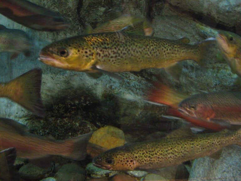
Photo: Rex Hammock, CC BY-SA 2.0
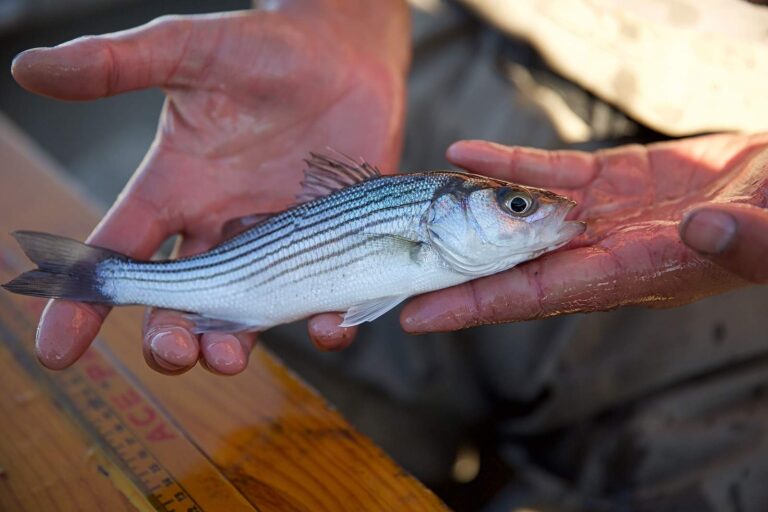
Photo: USFWS Pacific Southwest Region, Public domain

Photo: USFWS Mountain-Prairie, Public domain
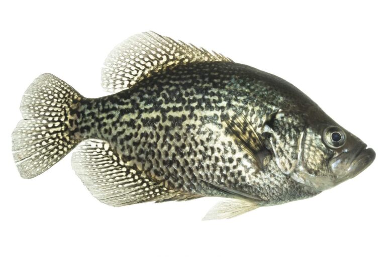
Photo: USFWS Mountain-Prairie, Public domain
Sorting out Mossy Creek, question by question
Which part of the Commonwealth holds Mossy Creek?
Set the map on Augusta County, about 5 miles from Bridgewater.
How many access sites serve Mossy Creek?
Lake Shenandoah boat ramp, some 11 miles away, is the closest.
Which species does DWR list for Mossy Creek?
DWR sources name brown trout, rainbow trout and rock bass.
Do DWR trout trucks visit Mossy Creek?
Hatchery trout go into 1 reach, category SR. Designated stocked trout waters require a trout license October 1 to June 15; urban waters November 1 to April 30 (as printed).
Do I measure bass on Mossy Creek?
The statewide digest row for largemouth and smallmouth bass reads: 5 per day in the aggregate (combined); No statewide length limits.
Which license do I carry on Mossy Creek?
A Virginia freshwater license is $23 a year for residents and $47 for nonresidents 16 and older. Designated stocked trout waters also need the $23 trout license from October 1 to June 15. Anglers under 16 need none.
Which USGS gauge reads Mossy Creek?
Our gauge list has nothing for it.
Does a listed fly or tackle store serve Mossy Creek?
Try Bridgewater Rod & Reel (about 4 miles away).
Read the USGS gauge, then fish Mossy Creek
Know the creel limits before the first cast.