Fishing in Josephine County, Oregon
County seat: Grants Pass. Population 88,090.
- 2lake pages
- 22open launches
- 3river pages
 Pick for crappiePiscifun Carbon X ultralight spinning reel28% OFFSale $57.99
Photo of Klamath River: Bureau of Land Management Oregon and Washington, CC BY 2.0
Josephine County fishing at a glance
County business for Josephine County happens in Grants Pass; the 2020 Census found 88,090 residents. Expect the ODFW Southwest Zone limits on most Josephine County waters; zones are drawn by drainage, so check any water near a divide.
Of the 2 lake guides tied to Josephine County, Lake Selmac covers the most surface. The Marine Board layer shows 22 open launches inside the county, 17 for trailers.
Census 2020 population; BLM Oregon NHD lake outlines; OSMB Boating Access Sites; DLCD and ODFW shore access layers; 2026 Oregon Sport Fishing Regulations zone lists; read November 2, 2026.
Pinning the fishing access in Josephine County
OSMB launch points, DLCD and ODFW shore sites, NHD lake points, PMEP estuary points; read November 2, 2026.
Lake guides for Josephine County
| Lake | Acres | Kind | OSMB launches | Fish mapped |
|---|---|---|---|---|
| Lake Selmac | 138 (outline) | lake | 2 | black crappie, bluegill, brown bullhead |
| Bolan Lake | 13 (outline) | lake | 1 | brook trout |
From Grants Pass the next paged lakes lie beyond Josephine County, closest first.
| Lake | From Grants Pass | Acres | Kind | OSMB launches | Fish mapped |
|---|---|---|---|---|---|
| Agate Reservoir | 29 miles east | 204 (outline) | reservoir | 1 | black crappie, bluegill, brown bullhead |
| Applegate Lake | 29 miles south | 949 (outline) | lake | 5 | black crappie, bluegill, brown bullhead |
| Galesville Reservoir | 30 miles north | 557 (outline) | reservoir | 2 | black crappie, bluegill, brown bullhead |
| Acorn Woman Lakes | 31 miles southeast | 55 (outline) | lake | 1 | black crappie, bluegill, brown bullhead |
| Lake Creek Reservoir | 36 miles east | 42 (outline) | reservoir | 0 | steelhead |
| Lost Creek Lake | 39 miles northeast | 2,522 (outline) | lake | 4 | black crappie, bluegill, brown bullhead |
BLM Oregon hydrography lake outlines (NHD), summed by GNIS name (layer), read November 2, 2026. Species: ODFW Fish Habitat Distribution layers (ODFW ArcGIS), read November 2, 2026; a mapped species is habitat use ODFW records, not a catch report. ODFW publishes no lake depths in these layers.
 For the crappie herePiscifun Carbon XT ultralight spinning reel25% OFFSale $59.99
Fish counts across waters by Josephine County
Out to 40 miles from Grants Pass, rainbow trout appears on more water pages than any other species.
Species from ODFW Fish Habitat Distribution layers, booklet exceptions and ODFW records, counted per water page within 40 miles; habitat mapping, not a catch survey.
More lake outlines across Josephine County
Another 4 named outlines fall in Josephine County.
| Water | Acres (outline) | Nearest place |
|---|---|---|
| Esterly Lakes | 22 | Cave Junction |
| Tanner Lake | 8 | Cave Junction |
| Miller Lake | 6 | Cave Junction |
| Strong Reservoir | 4 | Canyonville |
BLM Oregon hydrography lake outlines (NHD), summed by GNIS name (layer), read November 2, 2026.
Streams that cross Josephine County
- Applegate RiverODFW maps coho, fall chinook and spring chinook runs, 2 OSMB launches, 3 USGS gauges, 10 booklet exceptions
- Klamath RiverODFW maps coho, fall chinook and spring chinook runs, 4 OSMB launches, 9 USGS gauges, 2 booklet exceptions
- Rogue Rivertidewater at Rogue River, 44 OSMB launches, 7 USGS gauges, 44 booklet exceptions
Smaller rivers of Josephine County (2)
- East Fork Illinois RiverODFW maps coho, fall chinook and winter steelhead runs
- West Fork Illinois RiverODFW maps coho, fall chinook and winter steelhead runs
River readings across Josephine County
| USGS gauge | Latest reading | Time (ET) |
|---|---|---|
| Rogue River At Grants Pass, Or | 1,200 cfs, 1.10 ft gage height | Nov 13 1:20 am |
| Applegate River Near Wilderville, Or | 177 cfs, 2.18 ft gage height | Nov 13 1:20 am |
| Illinois River Near Kerby, Or | 74 cfs, 1.12 ft gage height | Nov 13 12:45 am |
| Sucker Creek Blw Little Grayback Ck, Nr Holland,or | 16 cfs, 1.09 ft gage height | Nov 13 1:00 am |
US Geological Survey provisional data, retrieved Nov 13, 2026 1:33 am ET. Provisional readings can be revised.
ODFW Fish Habitat Distribution stream names and runs, OSMB launches, booklet exceptions and USGS gauges; read November 2, 2026.
Launches listed for Josephine County
- Almeda Park on Rogue RiverRogue River, 1 lane, trailered launch
- Argo Access on Rogue RiverRogue River, hand carry launch
- Baker Park on Rogue RiverRogue River, 1 lane, trailered launch
- Bolan Lake Campground launchBolan Lake, hand carry launch
- Chinook Park on Rogue RiverRogue River, 1 lane, trailered launch
- Ennis Riffle boat ramp on Rogue RiverRogue River, 1 lane, trailered launch
- Ferry Hole Boat Landing on Rogue RiverRogue River, 1 lane, trailered launch
- Galice Boat Landing on Rogue RiverRogue River, 1 lane, trailered launch
- Grave Creek Landing on Rogue RiverRogue River, 2 lanes, trailered launch
- Griffin Park on Rogue RiverRogue River, 1 lane, trailered launch
- Hog Creek boat ramp on Rogue RiverRogue River, 2 lanes, trailered launch
- Indian Mary Park on Rogue RiverRogue River, 1 lane, trailered launch
- Kellers Landing on Lake SelmacLake Selmac, 3 lanes, trailered launch
- Lathrop Boat Landing on Rogue RiverRogue River, 1 lane, trailered launch
- Matson Park on Rogue RiverRogue River, 1 lane, hand carry launch
- McMullin Creek boat ramp on Lake SelmacLake Selmac, 1 lane, trailered launch
- Miami Bar launch on Illinois RiverIllinois River, 1 lane, hand carry launch
- Pierce Riffle boat ramp on Rogue RiverRogue River, 1 lane, trailered launch
- Rand Access on Rogue RiverRogue River, hand carry launch
- Robertson Bridge boat ramp on Rogue RiverRogue River, 1 lane, trailered launch
- Schroeder Park on Rogue RiverRogue River, 1 lane, trailered launch
- Whitehorse Park on Rogue RiverRogue River, 1 lane, trailered launch
OSMB status is shown as published: closed launches are listed without a page.
Oregon State Marine Board Boating Access Sites layer (OSMB ArcGIS), read November 2, 2026; status as OSMB publishes it. Oregon Coastal Management Program (DLCD) Shoreline Access Inventory (layer) and the ODFW shore access map, read November 2, 2026.
ODFW stocking for waters of Josephine County
Across 1 stocked waters in Josephine County, ODFW plans 10 releases and 38,000 trout.
- Lake Selmac10 releases planned, next listed: May. 24, 2027 – May. 28, 2027: 1,000 legal-size trout
ODFW weekly trout stocking schedule (planned releases; ODFW prints size classes, not species), myodfw.com, read November 2, 2026.
Keeper rules across Josephine County
The zone rows apply across Josephine County wherever no water exception steps in. Annual angling runs $50 for residents of Oregon and $138 for everyone else in 2026. Keep a salmon or steelhead and you need the Combined Angling Tag too, $69 for residents.
| Species | Limit | Season |
|---|---|---|
| Trout | Lakes: 5 per day, 3 daily limits in possession. Streams: (including tidewaters and bays); 2 per day, 3 daily catch limits in possession; 8-inch minimum | Lakes: Open all year Streams: (including tidewaters and bays): Open May 22 – Oct 31 unless noted under Exceptions. |
| Salmon and Steelhead | In the aggregate: 2 adult salmon or steelhead per day, 20 per year. 5 jack salmon per day, 2 daily jack limits in possession. Wild salmon bag limits are determined annually. | Closed unless noted under Exceptions. |
| Sturgeon | Catch-and-release only. | Streams: (including tidewaters and bays): Open during trout, salmon or steelhead seasons. |
| Bass | Lakes: 5 per day, 3 daily limits in possession unless noted under Exceptions. Streams: No limit. | Lakes: Open all year. Streams (including tidewaters and bays): Open during trout, salmon or steelhead seasons. |
| Bluegill, Catfish, Crappie, Other Sunfish, Walleye, Yellow Perch, Stri. | No limit. | Lakes: Open all year. Streams (including tidewaters and bays): Open during trout, salmon or steelhead seasons. |
| Smelt | Unless specifically authorized under emergency rules, it is unlawful to take or attempt to take Eulachon smelt in inland waters, including bays, rivers, estuaries, and streams. | Unless specifically authorized under emergency rules, it is unlawful to take or attempt to take Eulachon smelt in inland waters, including bays, rivers, estuari. |
| Marine Fish and Marine Shellfish | See Marine Zone. | See Marine Zone. |
Special rows reaching Josephine County (57)
| Water | Species | Rule | Booklet |
|---|---|---|---|
| Applegate River (Mouth to Applegate Dam) | trout | Open for hatchery trout Jan 1 – Mar 31 and May 22 – Dec 31, 2 per day. | p. 34 |
| Applegate River (Mouth to Applegate Dam) | trout, cutthroat | Wild rainbow trout and cutthroat trout must be released. | p. 34 |
| Applegate River (Mouth to Applegate Dam) | hatchery steelhead | Open for hatchery steelhead Jan 1 – Mar 31. | p. 34 |
| Applegate River (Mouth to Applegate Dam) | Use of bait allowed. | p. 34 | |
| Applegate River (Mouth to Applegate Dam) | No angling from a floating device. | p. 34 | |
| Applegate River (Mouth to Applegate Dam) | All tributaries closed, except Glade Cr. | p. 34 | |
| Applegate River (Mouth to Applegate Dam) | Closed from Applegate Dam downstream 1,500 ft to ODFW markers. | p. 34 | |
| Applegate River (Mainstem and tributaries above Applegate Dam) | trout | Open all year for trout. | p. 34 |
| Applegate River (Mainstem and tributaries above Applegate Dam) | steelhead, trout | Rainbow trout over 16 inches are not considered steelhead. | p. 34 |
| Applegate River (Mainstem and tributaries above Applegate Dam) | Use of bait allowed. | p. 34 | |
| Rogue River | trout | Open for hatchery rainbow trout Jan 1 – Mar 31 and May 22 – Dec 31. | p. 34 |
| Rogue River | trout | 5 hatchery rainbow trout per day. | p. 34 |
| Rogue River | trout, cutthroat | Wild rainbow trout and cutthroat trout must be released. | p. 34 |
| Rogue River | hatchery steelhead | Open all year for hatchery steelhead. | p. 34 |
| Rogue River | wild steelhead | Wild steelhead over 24 inches may be harvested Feb 1 – Apr 30; 1 per day and 3 per season. | p. 34 |
| Rogue River | coho, salmon | Open all year for hatchery coho salmon. | p. 34 |
| Rogue River | Gear Restriction: Any attached weight may be no more the 6 ft above the lower most hook, in addition to statewide Hook and Weight regulations. | p. 34 | |
| Rogue River | wild steelhead | Wild steelhead over 24 inches may be harvested Jan 1 – Apr 30 and Dec 1-31; 1 per day and 3 per season. | p. 34 |
| Rogue River | chinook, salmon | Open for hatchery Chinook salmon Jan 1 – May 31. | p. 34 |
| Rogue River | chinook, salmon | Open for Chinook salmon Jun 1 – Dec 31. | p. 34 |
Limits as printed in the 2026 Oregon Sport Fishing Regulations (ODFW, eRegulations edition) (Southwest Zone page), read November 2, 2026. Water exceptions as printed in the 2026 Oregon Sport Fishing Regulations (ODFW, eRegulations edition) (booklet PDF; printed page shown), read November 2, 2026. In-season changes from ODFW override them. Fees as printed on the ODFW license, tag and permit fee page of the 2026 Oregon Sport Fishing Regulations (ODFW, eRegulations edition) (fees page), read November 2, 2026.
State records from water by Josephine County
| Species | Weight | Water | Date |
|---|---|---|---|
| Rainbow Trout | 28 lb 0 oz | Rogue River | 1982 |
Oregon record fish as listed by Oregon Department of Fish and Wildlife (record fish article, dated March 4, 2026), read November 2, 2026.
Shops and charters in Josephine County
Tackle stores of Josephine County
- Bradbury's Gun-N-Tacklebait and tackle shop, Grants Pass
- Caveman Rod Shopbait and tackle shop, Grants Pass
- Rogue Fly Shopfly shop, Grants Pass
- U-Save Gas & Tacklebait and tackle shop, Grants Pass
- Bi-Mart (Grants Pass)sporting goods store, Grants Pass
Guide services of Josephine County
- Hotreels Fishing Guide Servicecharter, Cave Junction, (541) 660-9868
- R L Fishing Guide Servicecharter, Grants Pass, (541) 474-3259
- Jeff Staab Fishing Salmon & Steelhead Outfitter Guide Servicefishing guide, Cave Junction, (541) 415-0469
Yellow Pages and store-locator listings, guide and charter business listings (county of the business), read November 2, 2026.
In range of Josephine County
Base towns in Josephine County
- Grants Passpop. 39,189
- Redwoodpop. 2,702
- Cave Junctionpop. 2,071
Counties next to Josephine County
- Curry County33 miles west
- Jackson County46 miles east
- Coos County61 miles northwest
- Douglas County65 miles north
What Piscifun sells for a day spent on Josephine County


Piscifun and Amazon links are affiliate links; the site earns a commission on qualifying purchases.
Picture key to the fish of Josephine County
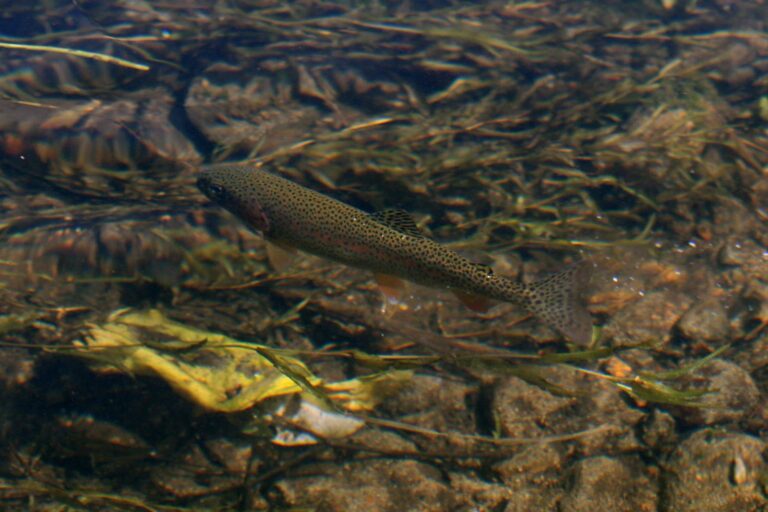
Photo: Alaska Region U.S. Fish & Wildlife Service, Public domain

Photo: U.S. Fish and Wildlife Service, Public domain

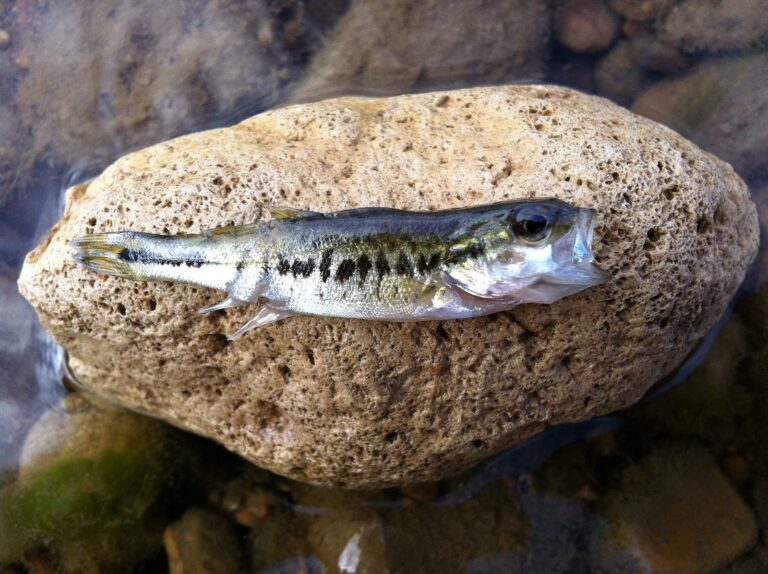
Photo: kmitschke, CC BY 2.0
Your Josephine County fishing questions, answered
How many boat launches are open in Josephine County?
22 open launches on the OSMB layer, 17 of them for trailers.
Which reservoir or lake tops Josephine County by size?
Lake Selmac, about 138 acres on its mapped outline.
Which fish lead the water pages near Josephine County?
Rainbow trout lead the count of water pages within 40 miles, then black crappie, bluegill and brown bullhead.
Which Josephine County stores stock salmon and trout tackle?
5 in all, Bradbury's Gun-N-Tackle first.
Is there a drift-boat or fishing guide listed in Josephine County?
3 guides and charters work from the county.
Which town is the administrative centre for Josephine County?
It is Grants Pass.
Do I need a license for water in Josephine County?
Oregon residents pay $50 for the annual angling license, visitors $138. Salmon, steelhead, sturgeon and halibut also go on a Combined Angling Tag ($69 resident).
Which counties touch Josephine County?
Start with Curry County, Jackson County and Coos County.
What zone table do Josephine County waters use?
The ODFW Southwest Zone rows cover most of the listed water in Josephine County; a drainage that crosses the line can carry another zone.
Which Josephine County waters get their own booklet rows?
The 2026 booklet prints 57 water exceptions reaching this county, starting with Applegate River; the table above shows each.
How many Josephine County waters are on the stocking schedule?
Yes: 1 water on the ODFW schedule, such as Lake Selmac; releases are planned, not confirmed.
Has an ODFW record fish been landed in Josephine County?
Rainbow Trout, 28 lb 0 oz, from Rogue River (1982).
Plan a day on the water in Josephine County
Every launch page opens with directions.