Fishing in Jackson County, Oregon
County seat: Medford. Population 223,259.
- 14lake pages
- 35open launches
- 3river pages
 Pick for crappiePiscifun Carbon X ultralight spinning reel28% OFFSale $57.99
Photo of Lost Creek Lake: Oregon Department of Fish & Wildlife, CC BY-SA 2.0
Water in Jackson County in figures
Jackson County has its county offices in Medford and counted 223,259 people in 2020. The ODFW Southwest Zone rows cover most of the listed water in Jackson County; a drainage that crosses the line can carry another zone.
14 lakes with a page of their own touch Jackson County; Lost Creek Lake has the biggest mapped outline. Count 35 open launches on the OSMB map for the county, 23 trailered.
Census 2020 population; BLM Oregon NHD lake outlines; OSMB Boating Access Sites; DLCD and ODFW shore access layers; 2026 Oregon Sport Fishing Regulations zone lists; read November 2, 2026.
The Jackson County water map
OSMB launch points, DLCD and ODFW shore sites, NHD lake points, PMEP estuary points; read November 2, 2026.
Choosing a lake in Jackson County
| Lake | Acres | Kind | OSMB launches | Fish mapped |
|---|---|---|---|---|
| Lost Creek Lake | 2,522 (outline) | lake | 4 | black crappie, bluegill, brown bullhead |
| Howard Prairie Lake | 1,981 (outline) | lake | 4 | brown bullhead, largemouth bass, pumpkinseed |
| Applegate Lake | 949 (outline) | lake | 5 | black crappie, bluegill, brown bullhead |
| Hyatt Reservoir | 844 (outline) | reservoir | 3 | black crappie, bluegill, brook trout |
| Emigrant Lake | 807 (outline) | lake | 4 | black crappie, channel catfish, largemouth bass |
| Fish Lake (Jackson County) | 380 (outline) | lake | 2 | brook trout, rainbow trout, chinook salmon |
| Willow Lake (Jackson County) | 319 (outline) | lake | 1 | black crappie, brown bullhead, largemouth bass |
| Agate Reservoir | 204 (outline) | reservoir | 1 | black crappie, bluegill, brown bullhead |
| Medco Pond | 69 (outline) | lake | 0 | black crappie, largemouth bass, rainbow trout |
| Acorn Woman Lakes | 55 (outline) | lake | 1 | black crappie, bluegill, brown bullhead |
| Lake Creek Reservoir | 42 (outline) | reservoir | 0 | steelhead |
| Keene Creek Reservoir | 12 (outline) | reservoir | 0 | brook trout, brown bullhead, pumpkinseed |
| Bounds Reservoir | 12 (outline) | reservoir | 0 | largemouth bass |
| Little Hyatt Reservoir | 10 (outline) | reservoir | 0 | brook trout, brown bullhead, largemouth bass |
BLM Oregon hydrography lake outlines (NHD), summed by GNIS name (layer), read November 2, 2026. Species: ODFW Fish Habitat Distribution layers (ODFW ArcGIS), read November 2, 2026; a mapped species is habitat use ODFW records, not a catch report. ODFW publishes no lake depths in these layers.
 For the crappie herePiscifun Carbon XT ultralight spinning reel25% OFFSale $59.99
Which fish ODFW maps around Jackson County
Tallying pages within 40 miles of Medford by species puts rainbow trout first.
Species from ODFW Fish Habitat Distribution layers, booklet exceptions and ODFW records, counted per water page within 40 miles; habitat mapping, not a catch survey.
Smaller named still water in Jackson County
These 31 named lakes of Jackson County have an outline but no guide yet.
| Water | Acres (outline) | Nearest place |
|---|---|---|
| Gold Ray Reservoir | 79 | Gold Hill |
| Indian Lake Reservoir | 49 | Shady Cove |
| Modoc Pond | 45 | White City |
| Yankee Creek Reservoir | 44 | Eagle Point |
| Sams Valley Reservoir | 41 | Gold Hill |
| North Fork Diversion Reservoir | 40 | Shady Cove |
| Medco Number 3 Pond | 39 | Central Point |
| Bradshaw Reservoir | 38 | Eagle Point |
| Woolfolk Reservoir | 29 | Eagle Point |
| Woodrat Knob Reservoir | 27 | Eagle Point |
| Kendall Slough | 26 | Central Point |
| Osborne Reservoir | 24 | Eagle Point |
| Wade Reservoir | 24 | Eagle Point |
| Reeder Reservoir | 21 | Ashland |
| Big Lake | 21 | Ashland |
| Stanley Reservoir | 18 | Eagle Point |
| Pierce Reservoir | 17 | Phoenix |
| Star Lake Reservoir | 16 | Eagle Point |
| Whetstone Pond | 15 | White City |
| Skou Reservoir | 14 | White City |
| Hobart Lake | 12 | Ashland |
| Harrison Reservoir | 12 | Eagle Point |
| Hammel Reservoir | 12 | Shady Cove |
| Hoover Pond Number One | 11 | White City |
| Parsnip Lakes | 11 | Ashland |
| Lake of the Cedars | 10 | Gold Hill |
| Hoover Reservoirs | 10 | White City |
| Lost Lake (Jackson County) | 6 | Ashland |
| McKee Lake | 4 | Eagle Point |
| Round Lake | 2 | Eagle Point |
| Blue Canyon Lake | 2 | Eagle Point |
BLM Oregon hydrography lake outlines (NHD), summed by GNIS name (layer), read November 2, 2026.
Rivers to fish across Jackson County
- Little Applegate RiverODFW maps coho, fall chinook and summer steelhead runs, 1 USGS gauge
- South Fork Rogue RiverODFW maps coho runs, 1 USGS gauge
- Rogue Rivertidewater at Rogue River, 44 OSMB launches, 7 USGS gauges, 44 booklet exceptions
Unpaged rivers crossing Jackson County (1)
- Middle Fork Rogue Riverstream
Live river flow in Jackson County
| USGS gauge | Latest reading | Time (ET) |
|---|---|---|
| Rogue River At Dodge Bridge, Near Eagle Point, Or | 1,180 cfs, 2.99 ft gage height | Nov 11 9:20 pm |
| Rogue River At Raygold Near Central Point, Or | 1,180 cfs, 0.85 ft gage height | Nov 11 9:20 pm |
| Rogue River Near Mcleod, Or | 1,060 cfs, 1.72 ft gage height | Nov 11 9:20 pm |
| Rogue R At Cole M Rivers F Hatchery Nr Mcleod, Or | 718 cfs, 1.69 ft gage height | Nov 11 9:20 pm |
| Rogue River Below Prospect, Or | 569 cfs, 1.26 ft gage height | Nov 11 9:20 pm |
| Applegate River Near Applegate, Or | 139 cfs, 1.11 ft gage height | Nov 11 9:20 pm |
US Geological Survey provisional data, retrieved Nov 11, 2026 9:33 pm ET. Provisional readings can be revised.
ODFW Fish Habitat Distribution stream names and runs, OSMB launches, booklet exceptions and USGS gauges; read November 2, 2026.
Putting in around Jackson County
- Acorn Woman Lakes Campground launchAcorn Woman Lakes, 1 lane, hand carry launch
- Agate Lake RampAgate Reservoir, 1 lane, trailered launch
- Applegate River AccessApplegate River, 1 lane, hand carry launch
- Cascade Boat Ramp on Hyatt ReservoirHyatt Reservoir, 1 lane, trailered launch, OSMB status: restricted
- Casey County Park on Rogue RiverRogue River, 1 lane, trailered launch
- Catfish Cove launch on Lost Creek LakeLost Creek Lake, 1 lane, hand carry launch
- Copper Boat Launch on Applegate LakeApplegate Lake, 1 lane, trailered launch, OSMB status: restricted
- Dees Landing on Rogue RiverRogue River, 1 lane, trailered launch
- Dodge Bridge boat ramp on Rogue RiverRogue River, 1 lane, trailered launch
- Dowden Falls Boat Launch on Rogue RiverRogue River, 1 lane, hand carry launch
- Expo Ponds launchExpo Ponds, hand carry launch
- Fish Lake Recreation Area boat rampFish Lake, 1 lane, trailered launch
- Fish Lake Resort launchFish Lake, 1 lane, hand carry launch
- Fishers Ferry boat ramp on Rogue RiverRogue River, trailered launch
- French Gulch boat ramp on Applegate LakeApplegate Lake, 1 lane, trailered launch
- Gold Hill Sports Park on Rogue RiverRogue River, 1 lane, trailered launch
- Gold Nugget Wayside on Rogue RiverRogue River, hand carry launch
- Grizzly Park Ramp on Howard Prairie LakeHoward Prairie Lake, 1 lane, trailered launch, OSMB status: restricted
- Hardy Riffle launch on Rogue RiverRogue River, 1 lane, hand carry launch
- Howard Prairie Resort boat rampHoward Prairie Lake, 3 lanes, trailered launch
- Klum Landing Ramp on Howard Prairie LakeHoward Prairie Lake, 2 lanes, trailered launch
- McGregor Boat Ramp on Rogue RiverRogue River, 2 lanes, trailered launch
- Patrick Dunn boat ramp on Emigrant LakeEmigrant Lake, 1 lane, trailered launch
- Provolt Recreation Site launch on Applegate RiverApplegate River, hand carry launch
- Rogue Elk boat rampRogue River, 1 lane, trailered launch
- Sardine Creek launch on Rogue RiverRogue River, 1 lane, hand carry launch
- Seattle Bar Day Use Area launch on Applegate LakeApplegate Lake, hand carry launch
- Songer Wayside on Emigrant LakeEmigrant Lake, 1 lane, trailered launch
- Takelma Park on Lost Creek LakeLost Creek Lake, 1 lane, trailered launch
- Takelma boat ramp on Rogue RiverRogue River, 1 lane, trailered launch
- TouVelle State Park on Rogue RiverRogue River, 1 lane, trailered launch
- Upper Rogue Regional ParkRogue River, 2 lanes, trailered launch
- Valley of the Rogue State ParkRogue River, 1 lane, trailered launch
- Willow Point Ramp on Howard Prairie LakeHoward Prairie Lake, 2 lanes, trailered launch
- Tipsu Tyee Boat-in Campground launch on Applegate LakeApplegate Lake, hand carry launch
- Emigrant Lake North boat rampEmigrant Lake, closed per OSMB
- Emigrant Lake West boat rampEmigrant Lake, closed per OSMB
- Hart-Tish Park Ramp on Applegate LakeApplegate Lake, closed per OSMB
- Joseph Stewart Resort Marina on Lost Creek LakeLost Creek Lake, closed per OSMB
- Joseph Stewart Resort Ramp on Lost Creek LakeLost Creek Lake, closed per OSMB
- Mountain View Ramp on Hyatt ReservoirHyatt Reservoir, closed per OSMB
- Wildcat Campground launch on Hyatt ReservoirHyatt Reservoir, closed per OSMB
- Willow Lake RampWillow Lake, closed per OSMB
The list follows the OSMB layer, including its closed and restricted flags.
Oregon State Marine Board Boating Access Sites layer (OSMB ArcGIS), read November 2, 2026; status as OSMB publishes it. Oregon Coastal Management Program (DLCD) Shoreline Access Inventory (layer) and the ODFW shore access map, read November 2, 2026.
Hatchery releases around Jackson County
Jackson County has 6 waters on the ODFW stocking schedule, with 36 planned releases totalling 251,684 trout.
- Lost Creek Lake11 releases planned, next listed: Oct. 04, 2027 – Oct. 08, 2027: 3,634 trophy trout
- Howard Prairie Lake3 releases planned, next listed: May. 17, 2027 – May. 21, 2027: 7,450 legal-size trout
- Applegate Lake5 releases planned, next listed: May. 17, 2027 – May. 21, 2027: 15,000 legal-size, 500 trophy trout
- Hyatt Reservoir4 releases planned, next listed: May. 24, 2027 – May. 28, 2027: 7,450 legal-size trout
- Emigrant Lake6 releases planned, next listed: May. 03, 2027 – May. 07, 2027: 1,000 legal-size trout
- Medco Pond7 releases planned, next listed: Jun. 14, 2027 – Jun. 18, 2027: 1,100 legal-size trout
ODFW weekly trout stocking schedule (planned releases; ODFW prints size classes, not species), myodfw.com, read November 2, 2026.
Fish an angler can carry home from Jackson County
Unless the booklet names a water, the zone table settles limits in Jackson County. The 2026 fee page lists the yearly angling license at $50 resident, $138 nonresident. For salmon and steelhead the booklet adds the Combined Angling Tag at $69 resident.
| Species | Limit | Season |
|---|---|---|
| Trout | Lakes: 5 per day, 3 daily limits in possession. Streams: (including tidewaters and bays); 2 per day, 3 daily catch limits in possession; 8-inch minimum | Lakes: Open all year Streams: (including tidewaters and bays): Open May 22 – Oct 31 unless noted under Exceptions. |
| Salmon and Steelhead | In the aggregate: 2 adult salmon or steelhead per day, 20 per year. 5 jack salmon per day, 2 daily jack limits in possession. Wild salmon bag limits are determined annually. | Closed unless noted under Exceptions. |
| Sturgeon | Catch-and-release only. | Streams: (including tidewaters and bays): Open during trout, salmon or steelhead seasons. |
| Bass | Lakes: 5 per day, 3 daily limits in possession unless noted under Exceptions. Streams: No limit. | Lakes: Open all year. Streams (including tidewaters and bays): Open during trout, salmon or steelhead seasons. |
| Bluegill, Catfish, Crappie, Other Sunfish, Walleye, Yellow Perch, Stri. | No limit. | Lakes: Open all year. Streams (including tidewaters and bays): Open during trout, salmon or steelhead seasons. |
| Smelt | Unless specifically authorized under emergency rules, it is unlawful to take or attempt to take Eulachon smelt in inland waters, including bays, rivers, estuaries, and streams. | Unless specifically authorized under emergency rules, it is unlawful to take or attempt to take Eulachon smelt in inland waters, including bays, rivers, estuari. |
| Marine Fish and Marine Shellfish | See Marine Zone. | See Marine Zone. |
Where the Jackson County limits change by water (52)
| Water | Species | Rule | Booklet |
|---|---|---|---|
| Lake Creek (Mouth to Indian Cr) | hatchery steelhead | Open for hatchery steelhead Jan 1 – Mar 31 and Dec 1 – Dec 31. | p. 29 |
| Lake Creek (Mouth to Indian Cr) | salmon | Closed all year to salmon angling. | p. 29 |
| Lake Creek (Indian Cr to Fish Cr) | hatchery steelhead | Open for hatchery steelhead Jan 1 – Mar 31 and Dec 1-31. | p. 29 |
| Lake Creek (Indian Cr to Fish Cr) | Closed Sep 1 – Nov 30. | p. 29 | |
| Lake Creek (All tributaries not listed) | Closed. | p. 29 | |
| Applegate Reservoir | salmon, trout | All landlocked salmon are considered trout. | p. 36 |
| Emigrant Reservoir | salmon, trout | All landlocked salmon are considered trout. | p. 36 |
| Lost Creek Reservoir | salmon, trout | All landlocked salmon are considered trout. | p. 37 |
| Rogue River | trout | Open for hatchery rainbow trout Jan 1 – Mar 31 and May 22 – Dec 31. | p. 34 |
| Rogue River | trout | 5 hatchery rainbow trout per day. | p. 34 |
| Rogue River | trout, cutthroat | Wild rainbow trout and cutthroat trout must be released. | p. 34 |
| Rogue River | hatchery steelhead | Open all year for hatchery steelhead. | p. 34 |
| Rogue River | wild steelhead | Wild steelhead over 24 inches may be harvested Feb 1 – Apr 30; 1 per day and 3 per season. | p. 34 |
| Rogue River | coho, salmon | Open all year for hatchery coho salmon. | p. 34 |
| Rogue River | Gear Restriction: Any attached weight may be no more the 6 ft above the lower most hook, in addition to statewide Hook and Weight regulations. | p. 34 | |
| Rogue River | wild steelhead | Wild steelhead over 24 inches may be harvested Jan 1 – Apr 30 and Dec 1-31; 1 per day and 3 per season. | p. 34 |
| Rogue River | chinook, salmon | Open for hatchery Chinook salmon Jan 1 – May 31. | p. 34 |
| Rogue River | chinook, salmon | Open for Chinook salmon Jun 1 – Dec 31. | p. 34 |
| Rogue River | Use of bait allowed except restricted to artificial flies and lures Sep 1 – Oct 31 from Foster Cr to Whisky Cr. | p. 34 | |
| Rogue River | Closed from ODFW markers 400 ft below Rainie Falls to Rainie Falls (RM 66). | p. 34 |
Limits as printed in the 2026 Oregon Sport Fishing Regulations (ODFW, eRegulations edition) (Southwest Zone page), read November 2, 2026. Water exceptions as printed in the 2026 Oregon Sport Fishing Regulations (ODFW, eRegulations edition) (booklet PDF; printed page shown), read November 2, 2026. In-season changes from ODFW override them. Fees as printed on the ODFW license, tag and permit fee page of the 2026 Oregon Sport Fishing Regulations (ODFW, eRegulations edition) (fees page), read November 2, 2026.
Oregon record fish near Jackson County
| Species | Weight | Water | Date |
|---|---|---|---|
| Rainbow Trout | 28 lb 0 oz | Rogue River | 1982 |
Oregon record fish as listed by Oregon Department of Fish and Wildlife (record fish article, dated March 4, 2026), read November 2, 2026.
Buying bait in Jackson County
Shops in Jackson County
- Arne Mason Fishing Tacklebait and tackle shop, Ashland
- Ashland Fly Shopfly shop, Ashland
- Beulah Fly Rodsbait and tackle shop, Medford
- RB Meiser Fly Rodsbait and tackle shop, Medford
- Rogue Valley Anglersfly shop, Medford
- Southern Oregon Fishingbait and tackle shop, Gold Hill
- The Fishin Hole Fly Shopfly shop, Shady Cove
- Bi-Mart (Ashland)sporting goods store, Ashland
- Bi-Mart (Medford/Bear Creek)sporting goods store, Medford
- Bi-Mart (Medford/W. Main St.)sporting goods store, Medford
- Dick's Sporting Goods Medfordsporting goods store, Medford
- Fish Lake Resortmarina, Eagle Point
- Sportsman's Warehouse Medfordsporting goods store, Medford
Guides listed in Jackson County
- Fishin Oregon Guide Servicecharter, Gold Hill, (541) 231-9993
- Fishing The Roguecharter, White City, (541) 326-9486
- Hooker Guide Servicecharter, Medford, (541) 621-7327
- Noah's Rafting & Fishing Tripscharter, Ashland, (541) 488-2811
- Oregon Fishingcharter, Medford, (541) 772-1383
- Southern Oregon Fishingfishing guide, Gold Hill, (541) 326-8780
Yellow Pages and store-locator listings, guide and charter business listings (county of the business), read November 2, 2026.
Not far from Jackson County
Towns in Jackson County
- Medfordpop. 85,824
- Ashlandpop. 21,360
- Central Pointpop. 18,997
- Eagle Pointpop. 9,686
- White Citypop. 9,090
- Talentpop. 6,282
- Phoenixpop. 4,475
- Shady Covepop. 3,081
- Jacksonvillepop. 3,020
- Rogue Riverpop. 2,407
- Gold Hillpop. 1,335
Next door to Jackson County
- Josephine County46 miles west
- Klamath County56 miles east
- Douglas County65 miles north
- Curry County78 miles west
Rods, reels and braid from Piscifun for Jackson County


Piscifun and Amazon links are affiliate links; the site earns a commission on qualifying purchases.
What the Jackson County species look like
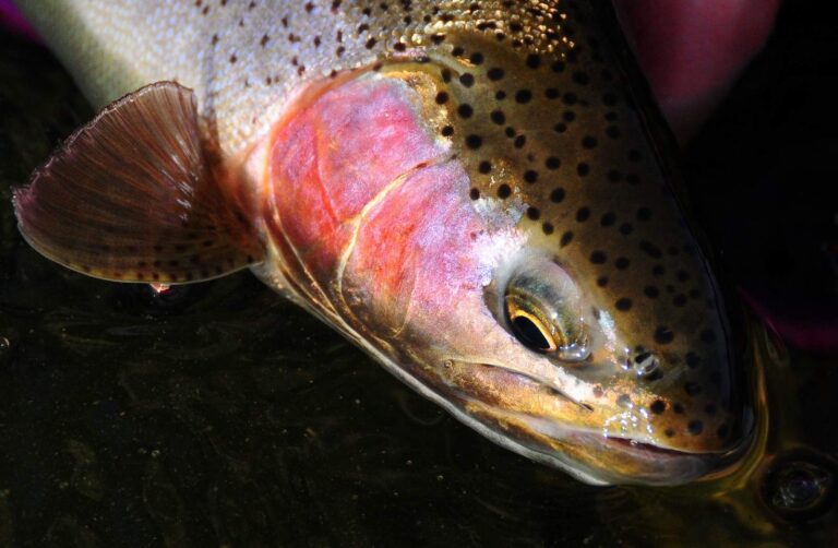
Photo: USFWS Mountain-Prairie, Public domain

Photo: gailhampshire, CC BY 2.0
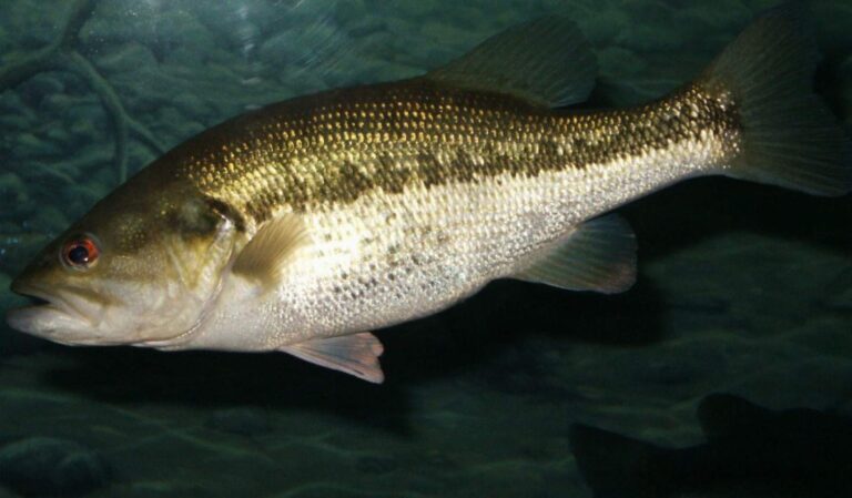
Photo: robposse, CC BY 2.0
Questions about lakes and streams in Jackson County
Which launches does the Marine Board map in Jackson County?
35 open launches; 23 are trailered ramps.
What is the biggest still water touching Jackson County?
Lost Creek Lake, about 2,522 acres on its mapped outline.
Which fish are mapped near Jackson County?
Rainbow trout lead the count of water pages within 40 miles, then largemouth bass, brown bullhead and black crappie.
Where do I restock tackle in Jackson County?
Arne Mason Fishing Tackle is one of 13 shops here.
Could I book a guided day out of Jackson County?
6 guides and charters list the county.
Which Oregon town houses Jackson County offices?
Government sits in Medford.
Which license covers a trip to Jackson County?
ODFW prices the 2026 annual angling license at $50 for Oregonians and $138 for nonresidents. Add the Combined Angling Tag, $69 resident, before keeping salmon or steelhead.
Which Oregon county pages adjoin Jackson County?
By distance: Josephine County, Klamath County and Douglas County.
Which ODFW zone covers Jackson County?
The ODFW Southwest Zone table governs most named water in Jackson County, but watershed boundaries decide each zone.
Which Jackson County waters carry their own rules?
The 2026 booklet prints 52 water exceptions reaching this county, starting with Lake Creek; the table above shows each.
Are trout plants planned in Jackson County?
Yes: 6 waters on the ODFW schedule, such as Lost Creek Lake, Howard Prairie Lake and Applegate Lake; releases are planned, not confirmed.
Does any Jackson County water hold an ODFW record?
Rainbow Trout, 28 lb 0 oz, from Rogue River (1982).
Work the waters of Jackson County
Read the exception table before keeping fish.