Roanoke River Fishing
Bertie County plus 4 other counties.
 Pick for troutPiscifun Carbon X ultralight spinning reel28% OFFSale $57.99
Photo: vastateparksstaff, CC BY 2.0
Getting oriented on the Roanoke River
Anglers find the Roanoke River, a river, in Bertie County plus 4 other counties. Roughly 154 miles of channel are on the map. The nearest incorporated town is Williamston, about 6 miles from its midpoint. About 46% of the river is mapped as coastal or joint water.
Live numbers come from 6 active gauges. Put-ins on file: 11 launches.
USGS sites on the Roanoke River
| USGS gauge | Latest reading | Time (ET) |
|---|---|---|
| Roanoke River At Roanoke Rapids, Nc | 1,450 cfs, 2.53 ft gage height | Nov 14 8:15 am |
| Roanoke River At Halifax, Nc | 16.84 ft gage height | Nov 14 8:15 am |
| Roanoke River Near Scotland Neck, Nc | 4.24 ft gage height | Nov 14 8:00 am |
| Roanoke River At Hamilton, Nc | 2.35 ft gage height | Nov 14 7:30 am |
| Roanoke River At Williamston, Nc | 1,530 cfs, 4.28 ft gage height | Nov 12 11:45 pm Not updated since Nov 12, 2007. |
| Roanoke River At Jamesville, Nc | 1.12 ft gage height | Nov 14 8:00 am |
US Geological Survey provisional data, retrieved Nov 14, 2026 8:33 am ET. Provisional readings can be revised.
Ramps, Roanoke River
- Gaston1 lane, 47 trailer spaces, 1 dock, Northampton County, inland waters
- Weldon Fallspaddle access, 10 trailer spaces, Halifax County, inland waters
- Weldon3 lanes, 57 trailer spaces, restrooms, 1 dock, Northampton County, inland waters
- Odom2 lanes, 20 trailer spaces, 2 docks, Northampton County, inland waters
- Edwards Ferry2 lanes, 41 trailer spaces, 1 dock, Northampton County, joint waters
- Lewiston Woodville2 lanes, 17 trailer spaces, 1 dock, Bertie County, joint waters
- Hamilton2 lanes, 38 trailer spaces, 1 dock, Martin County, joint waters
- NC Hwy 45 Bridge2 lanes, 25 trailer spaces, 1 dock, Washington County, joint waters
- Plymouth Water Street2 lanes, 36 trailer spaces, 2 docks, Washington County, joint waters
- Williamston2 lanes, 31 trailer spaces, restrooms, 2 docks, Martin County, joint waters
- Astoria Landing2 lanes, 45 trailer spaces, 2 docks, Martin County, joint waters
NCWRC Boating Access Areas, USACE, USFS and OpenStreetMap; midpoint from the NCWRC trout layer or USGS NHDPlus lines.
 For the trout herePiscifun Carbon XT ultralight spinning reel25% OFFSale $59.99
Fishing water classes, Roanoke River
Mapped shares for the Roanoke River: 54% inland, 46% joint, 0% coastal. Ramps along it carry these designations: 4 inland and 7 joint.
The Wildlife Resources Commission has jurisdiction in inland waters, and the Division of Marine Fisheries has jurisdiction (except that pertaining to inland game fishes) in coastal waters. Both agencies have licensing and regulatory authority in joint waters.
| County | Boundary in 15A NCAC 03Q .0202 |
|---|---|
| Bertie | Joint Waters south and Coastal Waters north of a line beginning at a point on the west shore of the Roanoke River 35° 56.5068' N 76° 41.8858' W; running easterly to a point on the east shore 35° 56.5324' N 76° 41.5896' W. |
| Halifax | Inland Waters northwest and Joint Waters southeast of a line beginning at a point on the west shore 36° 12.5264' N – 77° 23.0223' W; running northeasterly along the south side of the Highway 258 Bridge to a point on the east shore 36° 12.5674' N 77° 22.9724' W |
| Martin | All waters within this waterbody are designated as Joint. |
| Northampton | Inland Waters northwest and Joint Waters southeast of a line beginning at a point on the west shore 36° 12.5264' N – 77° 23.0223' W; running northeasterly along the south side of the Highway 258 Bridge to a point on the east shore 36° 12.5674' N 77° 22.9724' W |
Coastal and joint limits on the lower Roanoke River
| Species | Daily creel | Size | Season |
|---|---|---|---|
| Red drum | 1 a day | 18-27 in | Year-round |
| Flounder (all species) | 1 a day | 15 in minimum | Sept. 1-14, 2026 |
| Spotted seatrout | 3 a day | 14-20 in, plus 1 over 26 in | Open (reopened July 1, 2026) |
| Weakfish | 1 a day | 12 in minimum | open all year unless closed by proclamation |
| Black drum | 10 a day | 14-25 in, plus 1 over 25 in | open all year unless closed by proclamation |
| Sheepshead | 5 a day | 14 in minimum | open all year unless closed by proclamation |
| Striped bass (Albemarle Sound Management Area) | none may be kept | no size limit | open all year unless closed by proclamation |
| Bluefish | 5 a day | no size limit | open all year unless closed by proclamation |
| Spanish mackerel | 15 a day | 12 in minimum | open all year unless closed by proclamation |
NCWRC CoastJointWatersNC polygons, 15A NCAC 03Q .0202 and NCDMF proclamations, checked October 2026.
NCWRC limits on the Roanoke River
The Roanoke River appears by name in these NCWRC limits:
| Species | Size limit | Daily creel |
|---|---|---|
| Largemouth Bass | 14-inch minimum | 5 |
| Crappie (Black And White) | 8-inch minimum | 20 in combination |
| Crappie (Black And White) | 10-inch minimum | 20 in combination |
| Sunfish (Except Crappie, Rock Bass, & Roanoke Bass) | None | 30 in combination, including no more than 12 redbreast sunfish |
| Striped Bass And Bodie Bass (Striped Bass Hybrid) | 18-inch minimum, no fish may be greater than 22 inches (Season by proclamation only) | 1 in combination (Season by proclamation only) |
| Species | Daily creel | Size | Season |
|---|---|---|---|
| Largemouth and smallmouth bass | 5 a day | 14 in minimum | No closed season |
| Crappie | 20 a day | 8 in minimum | No closed season |
| Sunfish | 30 a day | no size limit | No closed season |
| White bass | 10 a day | no size limit | No closed season |
| Walleye | 8 a day | no size limit | No closed season |
| Rock and Roanoke bass | no creel limit | no size limit | No closed season |
| Blue, channel and flathead catfish | no creel limit | no size limit | No closed season |
| Trout (undesignated waters) | 7 a day | no size limit | No closed season |
NCWRC 2026-27 inland regulations. All North Carolina limits.
Just around Roanoke River
Nearby impoundments to Roanoke River
- Newbold Pond23 miles
- Grimesland Ponds24 miles
- Etheridge Pond24 miles
Bait counters nearest Roanoke River
- Roanoke Sportsmansporting goods store, Williamston, 6 miles
- Greenville Marinebait and tackle shop, Greenville, 25 miles
Towns encircling Roanoke River
- Williamston6 miles
- Hamilton6 miles
- Everetts8 miles
- Windsor10 miles
Creeks close to the Roanoke River
- Cashie River18 miles
- Conaby Creek23 miles
- Tranters Creek23 miles
- Chowan River27 miles
Counties that share Roanoke River
- Bertie County
- Northampton County
- Warren County
- Halifax County
- Martin County
Spinning, baitcasting and a weigh grip


Piscifun and Amazon links are affiliate links; the site earns a commission on qualifying purchases.
Species around Roanoke River, pictured
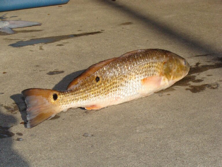
Photo: Geeklikepi, CC BY-SA 3.0


Photo: Mick Johnson, CC BY 3.0

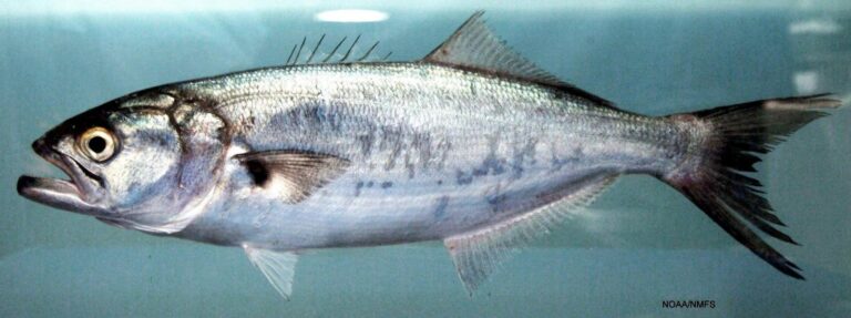
Photo: SEFSC Pascagoula Laboratory; Collection of Brandi Noble, NOAA/NMFS/SEFSC., Public domain

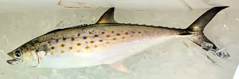
Photo: Donna Fernstrom, CC BY 4.0

Questions people send about the Roanoke River
Through which towns does the Roanoke River pass?
NCWRC maps it in Bertie County, Northampton County, Warren County, Halifax County and Martin County.
Can I keep trout from the Roanoke River?
No; it carries no trout class.
Is the Roanoke River on the stocking schedule?
Not on the 2026 stocking lists.
What does the Roanoke River gauge read?
See the 6 USGS gauges on this page.
Is the Roanoke River open to boat launching?
11 launches, such as Edwards Ferry.
Are the statewide NCWRC limits in force on the Roanoke River?
Largemouth Bass: 14-inch minimum, 5; Crappie (Black And White): 8-inch minimum, 20 in combination.
Which North Carolina license do I need for the Roanoke River?
Joint waters accept either the inland license ($32 resident) or the Coastal Recreational Fishing License ($20 resident) from age 16.
Which tackle counter is nearest the Roanoke River?
Roanoke Sportsman, roughly 6 miles from the midpoint.
How far is the Roanoke River from town?
Williamston, about 6 miles from the midpoint.
Put the Roanoke River on this year’s list
Buy the license from Go Outdoors North Carolina before the trip.