Fishing in Clearwater County, Idaho
County seat: Orofino. Population 8,734.
- 6lake pages
- 8launch sites
- 10river pages
 Pick for steelheadPiscifun Viper X spinning reel50% OFFSale $39.99
Photo of Dworshak Reservoir: Unknown author Unknown author or not provided, Public domain
What Clearwater County holds before you hitch the trailer
Clearwater County counted 8,734 residents in 2020 and runs its business from Orofino. Most of the county's listed waters (100%) fall in the IDFG Clearwater Region, though region lines follow drainages rather than county borders. Trail anglers have 46 high mountain lakes on the IDFG list.
Dworshak Reservoir heads 6 paged lakes in the county, which add up to 16,810 acres. Planner pages for Clearwater River, Orofino Creek, East Fork Potlatch River and North Fork Clearwater River include steelhead or salmon. Count 8 launch sites across the county: 8 IDFG. Shore fishing has 3 walk-in access sites mapped by IDFG.
Census 2020 population and county seat; IDFG Idaho Fishing Planner (list of Idaho waters), read November 7, 2026. IDFG Fishing and Boating Access Sites layer (ArcGIS service), read November 7, 2026.
 For the steelhead herePiscifun AlumiX spinning reel46% OFFSale $64.99
Pins for the fishing water of Clearwater County
IDFG Fishing and Boating Access Sites, BLM and Forest Service launch points, Fishing Planner lake points (outlet) and stream midpoints. Checked November 2026.
The Clearwater County lake list, sorted by size
| Lake | Acres | Launches | Kind | Game fish IDFG names |
|---|---|---|---|---|
| Dworshak Reservoir | 16,484 | 0 | reservoir | kokanee, cutthroat trout, smallmouth bass |
| Fish Lake (Clearwater County) | 114 | 0 | high mountain lake | |
| Elk Creek Reservoir | 87 | 1 | reservoir | bluegill and sunfish, bullhead, largemouth bass |
| Deer Creek Reservoir | 65 | 1 | reservoir | brook trout, rainbow trout, tiger trout |
| Deyo Reservoir | 52 | 1 | reservoir | bluegill and sunfish, largemouth bass, rainbow trout |
| Campbells Pond | 7 | 0 | lake | bluegill and sunfish, largemouth bass, rainbow trout |
Surface acres as listed in the IDFG Idaho Fishing Planner, read November 7, 2026. Game fish are the Planner’s recommended species; IDFG prints no lake depths there.
The Clearwater County game fish tally
Each bar tallies lakes within 50 miles of Orofino naming the fish, with rainbow trout first.
IDFG Fishing Planner recommended game fish and stocking rows, counted per lake page within 50 miles; not a creel survey.
Backcountry and pothole lakes the Planner lists in Clearwater County
The Planner names 49 more lakes in Clearwater County, the biggest listed first.
| Water | Acres | Kind | Nearest town |
|---|---|---|---|
| Kid Lake | 12 | high mountain lake | Kamiah |
| Leo Lake | 11 | high mountain lake | Kamiah |
| Goat Lake | 8 | high mountain lake | Kamiah |
| Cold Springs Pond | 8 | lake | Orofino |
| Elizabeth Lake | 7 | high mountain lake | Orofino |
| Pete Ott Lake | 6 | high mountain lake | Orofino |
| Lower Steep Lake | 6 | high mountain lake | Osburn |
| Upper Steep Lake | 6 | high mountain lake | Osburn |
| Goose Lake (Clearwater County) | 5 | high mountain lake | Osburn |
| Pot Lake | 4 | high mountain lake | Orofino |
| Cliff Lake | 4 | high mountain lake | Orofino |
| Kelly Lake | 4 | high mountain lake | Kamiah |
| Williams Lake | 4 | high mountain lake | Kamiah |
| Cayuse Lake | 4 | high mountain lake | Kamiah |
| Jack Lake | 4 | high mountain lake | Orofino |
| Black Mountain Lake | 3 | high mountain lake | Orofino |
| Buckingham Lake | 3 | high mountain lake | Orofino |
| Mush Lake | 3 | high mountain lake | Orofino |
| Junction Lake | 3 | high mountain lake | Kamiah |
| Smokey Lake | 3 | high mountain lake | Kamiah |
| Fly Lake | 2 | high mountain lake | Orofino |
| Ring Lake | 2 | high mountain lake | Orofino |
| Monroe Reservoir | 2 | high mountain lake | Kamiah |
| Platinum Lake | 2 | high mountain lake | Osburn |
| Tillie Lake | 2 | high mountain lake | Orofino |
| Olson Pond | 2 | lake | Orofino |
| Ellie Lake | 2 | high mountain lake | Orofino |
| Jaype Mill Pond | 2 | lake | Orofino |
| Scurvy Lake | 2 | high mountain lake | Kamiah |
| Ice Lake | 1 | high mountain lake | Orofino |
| Saddle Lake | 1 | high mountain lake | Orofino |
| West Pot Mountain Lake | 1 | high mountain lake | Orofino |
| Gem Lake | 1 | high mountain lake | Kamiah |
| Cold Lake | 1 | high mountain lake | Orofino |
| Tunnel Pond | 1 | lake | Orofino |
| East Pot Mountain Lake | 1 | high mountain lake | Orofino |
| Slide Lake | 0 | high mountain lake | Orofino |
| Steve Lake | 0 | high mountain lake | Orofino |
| Middle Steep Lake | 0 | high mountain lake | Osburn |
| Deadwood Lake | 0 | high mountain lake | Orofino |
| Deer Ridge Lake | 0 | high mountain lake | Kamiah |
| Lookout Lake | 0 | high mountain lake | Kamiah |
| Little Elizabeth Lake | 0 | high mountain lake | Orofino |
| North Flat Mountain Lake | 0 | high mountain lake | Orofino |
| Smith Creek Lake | 0 | high mountain lake | Kamiah |
| South Spring Lake | 0 | high mountain lake | Orofino |
| Spring Lake | 0 | high mountain lake | Orofino |
| Johnagon Lake | 0 | high mountain lake | Kamiah |
| West Flat Mountain Lake | 0 | high mountain lake | Orofino |
The Planner tags 46 as high mountain lakes. Idaho high mountain lakes
IDFG Idaho Fishing Planner (list of Idaho waters), read November 7, 2026.
Running water throughout Clearwater County
- Clearwater RiverIDFG recommended water, steelhead or salmon listed, 3 USGS gauges, 74.8 mi Planner length
- Little North Fork Clearwater RiverIDFG recommended water, 46.3 mi Planner length
- Orofino CreekIDFG recommended water, steelhead or salmon listed, 41.1 mi Planner length
- Elk CreekIDFG recommended water, 29.7 mi Planner length
- Kelly CreekIDFG recommended water, 26.2 mi Planner length
- Crooked ForkIDFG recommended water, 23.2 mi Planner length
- East Fork Potlatch RiverIDFG recommended water, steelhead or salmon listed, 21.8 mi Planner length
- Breakfast CreekIDFG recommended water, 10.9 mi Planner length
- Quartz CreekIDFG recommended water, 7.3 mi Planner length
- North Fork Clearwater Riversteelhead or salmon listed, 1 launch, 134.7 mi Planner length
Further IDFG-listed streams in Clearwater County (417)
- Lolo Creek47 mi
- Cayuse Creek35.9 mi
- Weitas Creek28.5 mi
- Jim Ford Creek23 mi
- Orogrande Creek20.1 mi
- Reeds Creek19.1 mi
- Little Canyon Creek18.8 mi
- Musselshell Creek17.6 mi
- Beaver Creek17.4 mi
- Washington Creek16.2 mi
- Skull Creek15.6 mi
- Whiskey Creek15.6 mi
- Hemlock Creek15 mi
- Floodwood Creek14.9 mi
- Middle Fork Saint Maries River14.6 mi
- Fourth of July Creek14 mi
- Quartz Creek14 mi
- Middle Creek13.7 mi
- Long Meadow Creek13.3 mi
- Meadow Creek13 mi
- Silver Creek12.9 mi
- Stony Creek12.6 mi
- Lake Creek12.5 mi
- Alder Creek12.3 mi
- Little Moose Creek12.1 mi
- Louse Creek11.4 mi
- Collins Creek11.2 mi
- Gold Creek10.3 mi
- Moose Creek10.2 mi
- Bedrock Creek10.1 mi
- Elkberry Creek10.1 mi
- Cedar Creek10 mi
- Canyon Creek9.8 mi
- Gravey Creek9.7 mi
- Jim Brown Creek9.7 mi
- Cedar Creek9.6 mi
- Long Creek9.6 mi
- Toboggan Creek9.4 mi
- Monroe Creek9.2 mi
- Glover Creek9 mi
- Isabella Creek9 mi
- Johnny Creek9 mi
- Big Creek8.9 mi
- Grasshopper Creek8.6 mi
- Isabella Creek8.6 mi
- Benton Creek8.5 mi
- Windy Creek8.5 mi
- Swamp Creek8.4 mi
- Osier Creek8.3 mi
- Waw’aalamnime Creek8.1 mi
- Cranberry Creek8 mi
- Rhodes Creek8 mi
- Boulder Creek7.8 mi
- North Fork Reeds Creek7.8 mi
- Rock Creek7.8 mi
- Snake Creek7.7 mi
- French Creek7.5 mi
- Goose Creek7.3 mi
- Smith Creek7.3 mi
- Three Bear Creek7.1 mi
- Johnagan Creek6.9 mi
- Deep Creek6.8 mi
- Swamp Creek6.8 mi
- Heywood Creek6.6 mi
- Ruby Creek6.5 mi
- Bobs Creek6.4 mi
- Howard Creek6.4 mi
- Breakfast Creek6.3 mi
- Elizabeth Creek6.3 mi
- Roaring Creek6.3 mi
- South Fork Kelly Creek6.2 mi
- Weitas Creek6.2 mi
- Larch Creek6.1 mi
- Scofield Creek6.1 mi
- Vanderbilt Gulch6.1 mi
- Cooper Creek6 mi
- Parallel Creek6 mi
- Dicks Creek5.9 mi
- North Fork Kelly Creek5.9 mi
- Texas Creek5.7 mi
USGS gauges posting from Clearwater County
| USGS gauge | Latest reading | Time (ET) |
|---|---|---|
| Clearwater River At Orofino Id | 1,680 cfs, 2.77 ft gage height | Nov 12 7:15 pm |
| Nf Clearwater River Nr Canyon Ranger Station Id | 745 cfs, 5.58 ft gage height | Nov 12 7:45 pm |
US Geological Survey provisional data, retrieved Nov 12, 2026 8:32 pm ET. Provisional readings can be revised.
IDFG Idaho Fishing Planner (list of Idaho waters), read November 7, 2026. Stream lengths as printed in the Planner; USGS gauges live.
Anadromous water across Clearwater County
- Clearwater RiverIDFG Clearwater Region
- Orofino CreekIDFG Clearwater Region
- East Fork Potlatch RiverIDFG Clearwater Region
- North Fork Clearwater RiverIDFG Clearwater Region
This page leaves out steelhead and salmon dates because the Commission proclamations were not reachable on the IDFG site in November 2026. Idaho steelhead and salmon rules
IDFG Idaho Fishing Planner (list of Idaho waters), read November 7, 2026.
Planted fish across Clearwater County
Planner pages for Clearwater County water print 622 stocking rows, 87,063,925 fish across 13 waters.
- Deer Creek ReservoirRainbow Trout – Triploid, 2,979 fish, Catchable (12-14 inches), October 8, 2026
- Elk Creek ReservoirRainbow Trout – Triploid, 2,979 fish, Catchable (12-14 inches), October 7, 2026
- Deyo ReservoirRainbow Trout – Triploid, 4,991 fish, Catchable (12-14 inches), October 6, 2026
- Elk Creek ReservoirRainbow Trout – Triploid, 1,201 fish, Catchable (12-14 inches), July 8, 2026
- Deyo ReservoirRainbow Trout – Triploid, 5,025 fish, Catchable (12-14 inches), June 30, 2026
- Campbells PondRainbow Trout – Triploid, 1,050 fish, Catchable (12-14 inches), June 30, 2026
- Elk Creek ReservoirRainbow Trout – Triploid, 3,080 fish, Catchable (12-14 inches), June 25, 2026
- Dworshak ReservoirRainbow Trout – Triploid, 4,060 fish, Catchable (12-14 inches), June 23, 2026
- Elk Creek ReservoirRainbow Trout – Triploid, 3,080 fish, Catchable (12-14 inches), June 10, 2026
- Deer Creek ReservoirRainbow Trout – Triploid, 3,080 fish, Catchable (12-14 inches), June 9, 2026
- Campbells PondRainbow Trout – Triploid, 1,005 fish, Catchable (12-14 inches), May 28, 2026
- Deyo ReservoirRainbow Trout – Triploid, 5,025 fish, Catchable (12-14 inches), May 26, 2026
Stocking rows as printed on the IDFG Fishing Planner water pages (date, species, number and size as listed), read November 7, 2026. Newest releases first.
IDFG, BLM and Forest Service sites in Clearwater County
- Ahsahka boat ramplaunch site, IDFG, boating access, ramp, restroom, camping
- Campbell Pond boat ramplaunch site, IDFG, boating access, ramp, dock, restroom, camping
- Deer Creek Reservoir boat rampDeer Creek Reservoir, IDFG, boating access, ramp, dock, restroom
- Deyo Reservoir boat rampDeyo Reservoir, IDFG, boating access, ramp, dock, restroom, camping
- Elk Creek Reservoir boat rampElk Creek Reservoir, IDFG, fishing access, ramp, dock, restroom, camping
- Greer launchlaunch site, IDFG, boating access, restroom, camping
- North Fork Clearwater River boat rampNorth Fork Clearwater River, IDFG, boating access, ramp, restroom, camping
- Zans boat ramplaunch site, IDFG, boating access, ramp, restroom, camping
Clearwater County fishing access without a ramp (3)
- Ahsahka Bridge fishing accessfishing access, restroom
- Clearwater Hatchery fishing accessfishing access
- McGill Spur fishing accessfishing access
IDFG Fishing and Boating Access Sites layer (ArcGIS service), read November 7, 2026. BLM and Forest Service points as published; lanes and ramp counts are not fields in any layer.
Region bag limits that cover most Clearwater County water
For most Clearwater County lakes and creeks the IDFG Clearwater Region limits apply; a few waters sit in a neighbouring region. By Idaho Code 36-416, residents owe $28.75 and nonresidents $106.25 for the annual fishing license, with vendor fees on top at the counter.
| Group | Rule as printed |
|---|---|
| Bass | In rivers and streams, no bag, length or possession limits; In lakes and reservoirs, limit is 6, both species combined |
| Brook Trout | Brook Trout limit is 25; Harvest allowed during any open season unless otherwise noted under Special Rules – if gear or bait restrictions are listed, they apply when fishing for Brook Trout |
| Bull Trout | Bull Trout – catch-and-release |
| Kokanee | Kokanee limit is 25 |
| Salmon | Spring and summer Chinook Salmon seasons and limits are set by the Idaho Fish and Game Commission and issued in separate brochures; Seasons and limits for fall Chinook Salmon and Coho Salmon can be found here; Sockeye Salmon fishing is prohibited. Defined as ocean-run Oncorhynchus nerka longer than 14 inches in the Snake River drainage below Hells Canyon Dam, the Salmon River drainage (excluding above Mosquito Flat D |
| Steelhead | Defined as Rainbow Trout longer than 20 inches in the Snake River drainage below Hells Canyon Dam, the Salmon River drainage (excluding lakes and reservoirs), and the Clearwater River drainage (excluding that portion above Dworshak Dam, and lakes); Fishing for steelhead is prohibited unless a steelhead season is specifically opened for that water. See fishing regulations for details |
| Sturgeon | Sturgeon – catch-and-release; Sturgeon must not be removed from the water and must be released upon landing; Barbless hooks, sliding swivel device to secure a weight, and a lighter test line to secure weight to sliding swivel device are required. See fishing regulations for details |
| Tiger Muskie | Tiger Muskie limit is 2, none under 40 inches |
| Trout | In rivers and streams, trout limit is 2, all species combined; In lakes, reservoirs, ditches and canals, trout limit is 6, all species combined; Bull Trout and Brook Trout are listed separately |
| Walleye | No bag, length, or possession limits. Harvest is encouraged (Stocked illegally in this Region. May be harmful to existing fisheries.) |
| Whitefish | Whitefish limit is 25; Harvest allowed during any open season unless otherwise noted under Special Rules – if gear or bait restrictions are listed, they apply when fishing for whitefish |
| Protected Nongame Fish | May not be harvested or possessed |
| All Other Fish Species | No bag, length, or possession limits |
Planner rule blocks inside Clearwater County (13)
- Breakfast CreekAll Waters Open All Year
- Clearwater RiverAll Waters Open All Year
- Crooked ForkAll Waters Open All Year
- Deer Creek ReservoirTrout limit is 6, only 2 may be Tiger Trout, no Tiger Trout under 20 inches
- Deyo ReservoirBass limit is 2, none under 16 inches
- Dworshak ReservoirTrout limit is 6, only 2 may be Cutthroat Trout, no Cutthroat Trout under 14 inches
- East Fork Potlatch RiverAll Waters Open All Year
- Elk CreekAll Waters Open All Year
- Kelly CreekAll Waters Open All Year
- Little North Fork Clearwater RiverAll Waters Open All Year
- North Fork Clearwater RiverAll Waters Open All Year
- Orofino CreekAll Waters Open All Year
- Quartz CreekAll Waters Open All Year
Region bag limits from Idaho Fishing Seasons and Rules, 2025-2027 for the Clearwater Region, as printed on IDFG Fishing Planner water pages (the brochure PDF on idfg.idaho.gov was unreachable during site maintenance), read November 7, 2026. Fishing license fees as set in Idaho Code 36-416 (statute; IDFG sale prices add vendor and processing fees), read November 7, 2026.
Clearwater County and the 2026 record list
| Species | Record | Kind | Water | Date |
|---|---|---|---|---|
| Rainbow Trout | 20.03 pounds | certified weight | Dworshak Reservoir | Jan. 13, 2026 |
Idaho state record fish, read November 8, 2026. A partial list: records IDFG announced in 2026.
Bait, flies and hired help in Clearwater County
Gem State tackle counters in Clearwater County
- Guide Shop-Clearwater Driftersbait and tackle shop, Orofino
- Riverside Sport Shopbait and tackle shop, Orofino
Guided trips from Clearwater County
- Hells Canyon Outfittersfishing guide, Orofino, (208) 816-6413
- The Outbackfishing guide, Pierce, (208) 464-2171
Yellow Pages and chain store listings, guide listings (city of business); retrieved November 7, 2026.
Close around Clearwater County
Clearwater County communities by size
- Orofinopop. 2,656
Idaho county pages around Clearwater County
- Lewis County47 miles southwest
- Shoshone County48 miles north
- Latah County52 miles west
- Idaho County58 miles south
Piscifun gear a Gem State angler might carry to Clearwater County


Piscifun and Amazon links are affiliate links; the site earns a commission on qualifying purchases.
Visual ID for fish swimming at Clearwater County
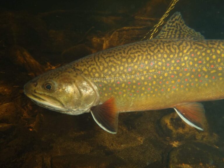
Photo: USFWS Midwest Region, Public domain
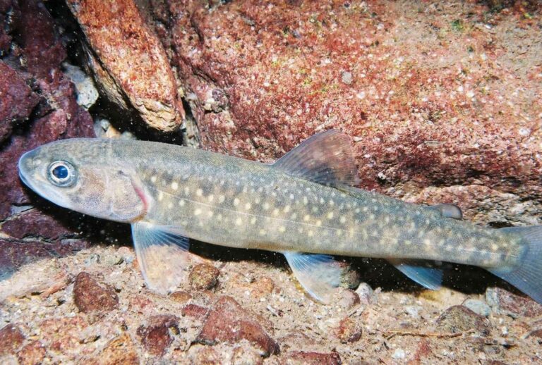
Photo: U.S. Fish and Wildlife Service, Public domain

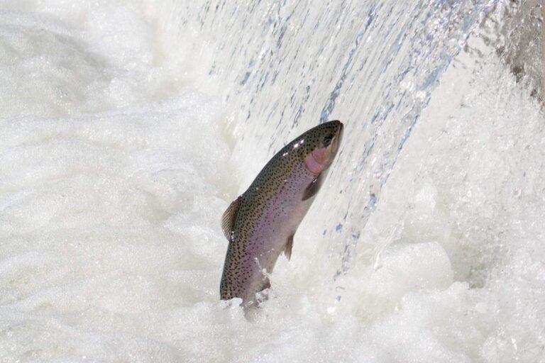
Photo: USFWS Pacific Southwest Region, Public domain
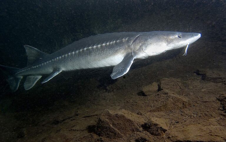
Photo: USFWS Fish and Aquatic Conservation, Public domain
Water across Clearwater County, in questions
Can I put a drift boat in somewhere in Clearwater County?
Count 8 launch sites, run as 8 IDFG.
Which Clearwater County reservoir tops the IDFG acreage list?
Dworshak Reservoir, at 16,484 acres in the IDFG Fishing Planner.
What ends up on the stringer around Clearwater County?
Rainbow trout lead the count of lake pages within 50 miles, followed by largemouth bass, bluegill and sunfish and bullhead.
Which Idaho stores sell Clearwater County anglers their bait and flies?
Try Guide Shop-Clearwater Drifters; the list holds 2.
Are any outfitters based in Clearwater County?
The file holds 2 guide listings.
Which Idaho town runs the business of Clearwater County?
Orofino hosts the county offices.
What does Idaho Code 36-416 set for a visiting angler fishing Clearwater County?
By Idaho Code 36-416, residents owe $28.75 and nonresidents $106.25 for the annual fishing license, with vendor fees on top at the counter.
Which Idaho county guide should Clearwater County anglers try after this one?
Closest by centre point: Lewis County, Shoshone County and Latah County.
Which IDFG region holds most Clearwater County water?
The IDFG Clearwater Region holds 100% of the listed water here.
Which IDFG special rules apply to Clearwater County water?
The Planner prints special rules for 13 county waters with a page here, starting with Breakfast Creek; the list above shows the first ones.
What record catches trace to Clearwater County?
Rainbow Trout, 20.03 pounds (certified weight), from Dworshak Reservoir, announced by IDFG in 2026.
Is there stocked water in Clearwater County?
622 IDFG releases listed on Planner pages, 87,063,925 fish; the newest went into Deer Creek Reservoir on Oct. 8, 2026.
Which Clearwater County rivers list steelhead?
The Planner lists steelhead or salmon on Clearwater River, Orofino Creek and East Fork Potlatch River. Steelhead and salmon need a Commission season to be open, and those proclamations sat behind IDFG maintenance when this page was written.
Plan an Idaho weekend of fishing in Clearwater County
Lake pages list launches, stocking and IDFG game fish.