Fishing in Shoshone County, Idaho
County seat: Wallace. Population 13,169.
- 4lake pages
- 1launch sites
- 11river pages
 Pick for steelheadPiscifun Viper X spinning reel50% OFFSale $39.99
Photo of Lake Pend Oreille: MonikaMurren, CC BY 2.0
Where the fishing in Shoshone County starts
At the 2020 Census Shoshone County held 13,169 residents, with county offices in Wallace. By the Planner's count, 55% of the county's listed lakes and streams belong to the IDFG Panhandle Region. 47 high mountain lakes in the county are filed as high mountain lakes.
Largest among 4 lake pages is Heart Lake; the set spans 69 acres. Among county streams, North Fork Clearwater River list steelhead or salmon as game fish. The access layers map 1 launch site in the county (1 IDFG). Bank anglers get 4 walk-in access sites on the IDFG layer.
Census 2020 population and county seat; IDFG Idaho Fishing Planner (list of Idaho waters), read November 7, 2026. IDFG Fishing and Boating Access Sites layer (ArcGIS service), read November 7, 2026.
 For the steelhead herePiscifun AlumiX spinning reel46% OFFSale $64.99
Every IDFG launch and lake page in Shoshone County, pinned
IDFG Fishing and Boating Access Sites, BLM and Forest Service launch points, Fishing Planner lake points (outlet) and stream midpoints. Checked November 2026.
Which Shoshone County lakes have a full guide
| Lake | Acres | Launches | Kind | Game fish IDFG names |
|---|---|---|---|---|
| Heart Lake | 33 | 0 | high mountain lake | rainbow trout |
| Elsie Lake | 16 | 0 | high mountain lake | brook trout, rainbow trout |
| Lower Glidden Lake | 14 | 0 | high mountain lake | brook trout, rainbow trout |
| Dismal Lake | 6 | 0 | high mountain lake | rainbow trout |
Surface acres as listed in the IDFG Idaho Fishing Planner, read November 7, 2026. Game fish are the Planner’s recommended species; IDFG prints no lake depths there.
What IDFG recommends on water close to Shoshone County
Bars count lake pages within 50 miles of Wallace where IDFG recommends or stocks each fish; largemouth bass tops it.
IDFG Fishing Planner recommended game fish and stocking rows, counted per lake page within 50 miles; not a creel survey.
Unpaged lakes across Shoshone County
54 further lakes of Shoshone County, many of them alpine, stay on this list until more is published.
| Water | Acres | Kind | Nearest town |
|---|---|---|---|
| Lost Lake | 27 | high mountain lake | Osburn |
| Lower Stevens Lake | 24 | high mountain lake | Osburn |
| Saint Joe Lake | 18 | high mountain lake | Osburn |
| Upper Glidden Lake | 16 | high mountain lake | Osburn |
| Revett Lake | 16 | high mountain lake | Osburn |
| Skyland Lake | 11 | high mountain lake | Osburn |
| Northbound Lake | 10 | high mountain lake | Osburn |
| Upper Stevens Lake | 10 | high mountain lake | Osburn |
| Fawn Lake | 10 | high mountain lake | Osburn |
| Halo Lake | 9 | high mountain lake | Osburn |
| Steamboat Lake | 8 | high mountain lake | Osburn |
| Larkins Lake | 8 | high mountain lake | Osburn |
| Silver Lake | 7 | high mountain lake | Osburn |
| Crag Lake | 7 | high mountain lake | Osburn |
| Heather Lake | 6 | high mountain lake | Osburn |
| Fish Lake (Shoshone County) | 6 | high mountain lake | Osburn |
| Forage Lake | 6 | high mountain lake | Osburn |
| Hero Lake | 6 | high mountain lake | Osburn |
| No-see-um Lake | 5 | high mountain lake | Osburn |
| Big Talk Lake | 5 | high mountain lake | Osburn |
| Mud Lake (Shoshone County) | 5 | high mountain lake | Osburn |
| Theriault Lake | 4 | high mountain lake | Osburn |
| Bacon Lake | 4 | high mountain lake | Osburn |
| Lost Lake | 4 | high mountain lake | Osburn |
| Lone Lake | 4 | high mountain lake | Osburn |
| Urquhart Lake | 4 | lake | St. Maries |
| Crater Lake | 4 | high mountain lake | Osburn |
| Gnat Lake | 4 | high mountain lake | Osburn |
| Gold Lake | 4 | high mountain lake | Osburn |
| Copper Lake | 3 | high mountain lake | Osburn |
| Gold Lake | 3 | high mountain lake | Osburn |
| Little Lost Lake | 3 | high mountain lake | Osburn |
| Swimming Bear Lake | 3 | high mountain lake | Osburn |
| Simmons Lake | 3 | high mountain lake | Osburn |
| Star Lake | 3 | high mountain lake | Osburn |
| Frog Lake | 3 | high mountain lake | Osburn |
| Devils Lake | 3 | high mountain lake | Osburn |
| Steamboat Pond | 3 | lake | Kellogg |
| Tin Lake | 2 | high mountain lake | Osburn |
| Crow Lake | 2 | high mountain lake | Osburn |
| Gene Day Pond | 2 | lake | Osburn |
| Calder Pond | 2 | lake | Osburn |
| Lucky Friday Pond | 2 | lake | Osburn |
| Pine Creek Pond | 1 | lake | Pinehurst |
| Jug Lake | 1 | high mountain lake | Osburn |
| Mallard Lake | 1 | high mountain lake | Osburn |
| Berry Lake | 1 | high mountain lake | Osburn |
| Seed lake | 1 | high mountain lake | Osburn |
| Gold Creek Pond | 1 | lake | Osburn |
| Murray Pond | 1 | lake | Osburn |
| Blue Lake (Shoshone County) | 0 | high mountain lake | Osburn |
| Clee Creek Pond | 0 | lake | Osburn |
| Day Rock Pond | 0 | lake | Osburn |
| Osburn Pond | 0 | lake | Osburn |
Trail-reached alpine lakes account for 47. Idaho high mountain lakes
IDFG Idaho Fishing Planner (list of Idaho waters), read November 7, 2026.
River guides crossing Shoshone County
- Saint Joe RiverIDFG recommended water, 3 USGS gauges, 144.9 mi Planner length
- North Fork Coeur d'Alene RiverIDFG recommended water, 76.9 mi Planner length
- Little North Fork Clearwater RiverIDFG recommended water, 46.3 mi Planner length
- Saint Maries RiverIDFG recommended water, 1 USGS gauge, 45.8 mi Planner length
- Little North Fork Coeur d'Alene RiverIDFG recommended water, 38.7 mi Planner length
- South Fork Coeur d'Alene RiverIDFG recommended water, 35.8 mi Planner length
- Marble CreekIDFG recommended water, 25.7 mi Planner length
- North Fork Saint Joe RiverIDFG recommended water, 20.6 mi Planner length
- North Fork Clearwater Riversteelhead or salmon listed, 1 launch, 134.7 mi Planner length
- Coeur d'Alene River38.1 mi Planner length
- Ninemile Creek1 USGS gauge, 5.2 mi Planner length
Planner streams of Shoshone County without a guide (745)
- Slate Creek21.2 mi
- Shoshone Creek18.8 mi
- Tepee Creek18.3 mi
- Independence Creek16 mi
- Floodwood Creek14.9 mi
- Middle Fork Saint Maries River14.6 mi
- Prichard Creek14.6 mi
- Mica Creek14.2 mi
- Sisters Creek13.9 mi
- Meadow Creek13 mi
- Loop Creek12.6 mi
- Stony Creek12.6 mi
- Beaver Creek12.4 mi
- Canyon Creek12.4 mi
- Simmons Creek12.4 mi
- Canyon Creek12.2 mi
- Collins Creek11.2 mi
- Pine Creek11.2 mi
- Bond Creek11 mi
- Sawtooth Creek10.8 mi
- Big Creek10.7 mi
- West Fork Saint Maries River10.7 mi
- West Fork Eagle Creek10.4 mi
- Gold Creek9.8 mi
- East Fork Eagle Creek9.7 mi
- Foehl Creek9.6 mi
- Long Creek9.6 mi
- Trout Creek9.4 mi
- Big Creek9.1 mi
- East Fork Big Creek9 mi
- East Fork Emerald Creek9 mi
- Glover Creek9 mi
- Lost Creek8.5 mi
- Quartz Creek8.5 mi
- Boulder Creek8.3 mi
- Hugus Creek8.1 mi
- Fishhook Creek8 mi
- Placer Creek8 mi
- East Fork Bluff Creek7.9 mi
- West Fork Bluff Creek7.8 mi
- Beaver Creek7.6 mi
- Bussel Creek7.6 mi
- Bear Creek7.5 mi
- Merry Creek7.5 mi
- Flat Creek7.4 mi
- West Fork Slate Creek7.4 mi
- Renfro Creek7.3 mi
- Black Prince Creek7.2 mi
- West Fork Floodwood Creek7.1 mi
- Cougar Gulch7 mi
- Daveggio Creek7 mi
- East Fork Pine Creek7 mi
- Mosquito Creek7 mi
- Falls Creek6.9 mi
- Trail Creek (Kootenai County)6.9 mi
- Copper Creek6.7 mi
- Crystal Creek6.7 mi
- Homestead Creek6.7 mi
- Bear Creek6.6 mi
- Bird Creek6.6 mi
- Buck Creek6.6 mi
- Eagle Creek6.6 mi
- Fly Creek6.5 mi
- Olson Creek6.5 mi
- Spotted Louis Creek6.5 mi
- Spruce Creek6.5 mi
- Middle Fork Big Creek6.4 mi
- Roaring Creek6.3 mi
- Skookum Creek6.3 mi
- Big Elk Creek6.2 mi
- Alpine Creek6.1 mi
- East Fork Lost Creek6.1 mi
- Gold Center Creek6.1 mi
- Vanderbilt Gulch6.1 mi
- Bear Gulch6 mi
- West Fork Big Creek6 mi
- Red Ives Creek5.9 mi
- Hobo Creek5.8 mi
- Lick Creek5.8 mi
- West Fork Pine Creek5.8 mi
Gauge stations of Shoshone County
| USGS gauge | Latest reading | Time (ET) |
|---|---|---|
| St Joe River At Calder, Id | 385 cfs, 5.26 ft gage height | Nov 13 7:30 pm |
| Coeur D Alene River Nr Cataldo Id | 395 cfs, 32.73 ft gage height | Nov 13 8:15 pm |
| Nf Coeur D Alene River At Enaville Id | 280 cfs, 57.51 ft gage height | Nov 13 7:45 pm |
| Sf Coeur D Alene River Nr Pinehurst, Id | 96 cfs, 5.62 ft gage height | Nov 13 8:00 pm |
| Nf Coeur D Alene R Ab Shoshone Ck Nr Prichard Id | 89 cfs, 1.18 ft gage height | Nov 13 8:15 pm |
| Sf Coeur D Alene River Abv Pine Cr Nr Pinehurst Id | 71 cfs, 87.87 ft gage height | Nov 13 7:15 pm |
US Geological Survey provisional data, retrieved Nov 13, 2026 8:32 pm ET. Provisional readings can be revised.
IDFG Idaho Fishing Planner (list of Idaho waters), read November 7, 2026. Stream lengths as printed in the Planner; USGS gauges live.
Ocean-run fish on Shoshone County rivers
- North Fork Clearwater RiverIDFG Clearwater Region
The Commission opens steelhead and salmon by separate proclamation; check IDFG before fishing them, as those pages were offline when this was built. Idaho steelhead and salmon rules
IDFG Idaho Fishing Planner (list of Idaho waters), read November 7, 2026.
The Shoshone County stocking log
Hatchery trucks made 1,705 listed stops in Shoshone County, leaving 53,048,104 fish in 12 waters.
- Lower Glidden LakeRainbow Trout – Triploid, 1,350 fish, Catchable (12-14 inches), July 30, 2026
- Elsie LakeRainbow Trout – Triploid, 1,620 fish, Catchable (12-14 inches), June 30, 2026
- Dismal LakeRainbow Trout – Triploid, 438 fish, Catchable (12-14 inches), June 30, 2026
- North Fork Clearwater RiverChinook Salmon, 714,042 fish, Fingerling (3-6 inches), April 16, 2026
- Heart LakeRainbow Trout – Triploid, 6,401 fish, Fry (0-3 inches), September 19, 2025
- Elsie LakeRainbow Trout – Triploid, 746 fish, Catchable (12-14 inches), June 23, 2025
- Lower Glidden LakeRainbow Trout – Triploid, 1,366 fish, Catchable (12-14 inches), June 19, 2025
- Elsie LakeRainbow Trout – Triploid, 1,466 fish, Catchable (12-14 inches), June 19, 2025
- Dismal LakeRainbow Trout – Triploid, 270 fish, Catchable (12-14 inches), May 29, 2025
- North Fork Clearwater RiverChinook Salmon, 298,705 fish, Fingerling (3-6 inches), April 10, 2025
- North Fork Clearwater RiverChinook Salmon, 363,934 fish, Fingerling (3-6 inches), March 27, 2025
- Elsie LakeRainbow Trout – Triploid, 450 fish, Catchable (6+ inches), August 21, 2024
Stocking rows as printed on the IDFG Fishing Planner water pages (date, species, number and size as listed), read November 7, 2026. Newest releases first.
Mapped water access across Shoshone County
- Freeman's Eddy- North Fork CDA River boat ramplaunch site, IDFG, boating access, ramp, restroom
Walk-in IDFG access in Shoshone County (4)
- Day Rock Pondfishing access
- Gene Day Ponds fishing accessfishing access
- Lucky Friday Pondfishing access
- Steamboat Ponds fishing accessfishing access, dock, restroom
IDFG Fishing and Boating Access Sites layer (ArcGIS service), read November 7, 2026. BLM and Forest Service points as published; lanes and ramp counts are not fields in any layer.
IDFG region table for Shoshone County
Rows below come from the IDFG Panhandle Region, which covers the bulk of the county's Planner waters; water-specific rules override them. The statute behind Idaho licenses, Code 36-416, puts the annual fishing fee at $28.75 resident and $106.25 nonresident; sale prices run a little higher.
| Group | Rule as printed |
|---|---|
| Bass | Bass limit is 6, both species combined |
| Brook Trout | Brook Trout limit is 25; Harvest allowed during any open season unless otherwise noted under Special Rules – if gear or bait restrictions are listed, they apply when fishing for Brook Trout |
| Bull Trout | Bull Trout – catch-and-release |
| Burbot | Burbot limit is 6 |
| Chinook Salmon | Chinook Salmon limit is 2, none under 24 inches |
| Kokanee | Kokanee limit is 15 |
| Northern Pike | No bag, length, or possession limits. Harvest is encouraged (Stocked illegally in this Region. May be harmful to existing fisheries.) |
| Sturgeon | Fishing for sturgeon in the Kootenai River is illegal; Sturgeon caught incidentally must be released immediately |
| Tiger Muskie | Tiger Muskie limit is 2, none under 40 inches |
| Trout | Trout limit is 6, all species combined; Bull Trout and Brook Trout are listed separately |
| Walleye | No bag, length, or possession limits. Harvest is encouraged (Stocked illegally in this Region. May be harmful to existing fisheries.) |
| Whitefish | Whitefish limit is 25; Harvest allowed during any open season unless otherwise noted under Special Rules – if gear or bait restrictions are listed, they apply when fishing for whitefish |
| All Other Fish Species | No bag, length, or possession limit |
A share of the listed water sits in the IDFG Clearwater Region. Every region table
Special rules on Shoshone County lakes and streams (11)
- Coeur d'Alene RiverAll Waters Open All Year
- Little North Fork Clearwater RiverAll Waters Open All Year
- Little North Fork Coeur d'Alene RiverAll Waters Open All Year
- Lower Glidden LakeElectric motors only
- Marble CreekAll Waters Open All Year
- North Fork Clearwater RiverAll Waters Open All Year
- North Fork Coeur d'Alene RiverAll Waters Open All Year
- North Fork Saint Joe RiverAll Waters Open All Year
- Saint Joe RiverAll Waters Open All Year
- Saint Maries RiverAll Waters Open All Year
- South Fork Coeur d'Alene RiverAll Waters Open All Year
Region bag limits from Idaho Fishing Seasons and Rules, 2025-2027 for the Panhandle Region, as printed on IDFG Fishing Planner water pages (the brochure PDF on idfg.idaho.gov was unreachable during site maintenance), read November 7, 2026. Fishing license fees as set in Idaho Code 36-416 (statute; IDFG sale prices add vendor and processing fees), read November 7, 2026.
IDFG record announcements close to Shoshone County
For Shoshone County, the closest 2026 record waters lie within 80 miles.
| Species | Record | Kind | Water | Date |
|---|---|---|---|---|
| Westslope Cutthroat Trout | 27 inches | catch-and-release (length) | Lake Pend Oreille | Feb. 1, 2026 |
| Northern Pike | 49.75 inches | catch-and-release (length) | Lake Pend Oreille | June 13, 2026 |
| Rainbow Trout | 20.03 pounds | certified weight | Dworshak Reservoir | Jan. 13, 2026 |
Idaho state record fish, read November 8, 2026. A partial list: records IDFG announced in 2026.
Shoshone County fly shops and guide services
Idaho fly shops and bait counters of Shoshone County
- CRYSTAL SPRINGS TROUT— YOU CATCH!bait and tackle shop, Kingston
- Valley Fishin Holebait and tackle shop, Smelterville
Yellow Pages and chain store listings, guide listings (city of business); retrieved November 7, 2026.
Idaho backroads fanning out from Shoshone County
Town guides inside Shoshone County
- Kelloggpop. 2,314
- Pinehurstpop. 1,679
- Osburnpop. 1,567
County pages next to Shoshone County
- Benewah County36 miles west
- Kootenai County44 miles northwest
- Clearwater County48 miles south
- Latah County54 miles southwest
Piscifun reels and line packed for Shoshone County


Piscifun and Amazon links are affiliate links; the site earns a commission on qualifying purchases.
Gem State fish to know on sight at Shoshone County
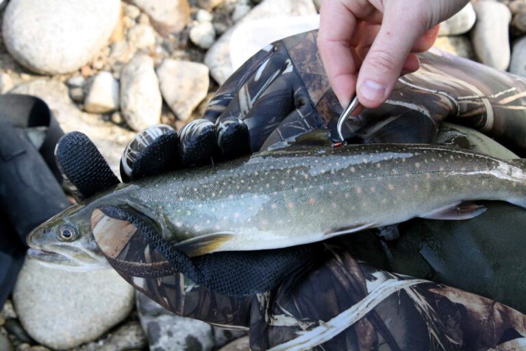
Photo: Bureau of Reclamation, CC BY-SA 2.0
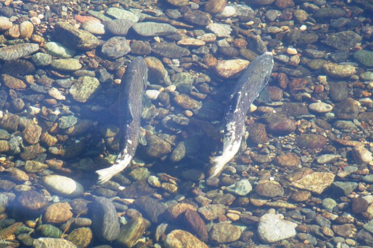
Photo: Dan Cook (USFWS), Public domain

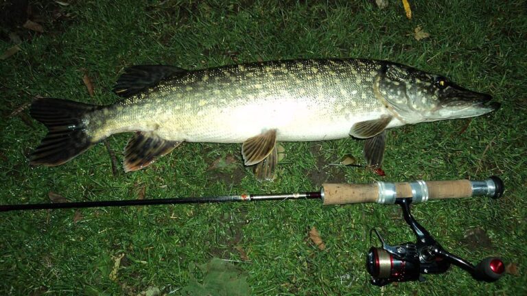
Photo: Aszazin, CC BY-SA 3.0

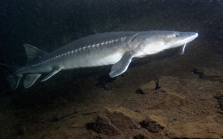
Photo: Oregon Department of Fish & Wildlife, CC BY-SA 2.0

Fishing within Shoshone County: the usual questions
Where can a trailer reach the water in Shoshone County?
There are 1 launch site, split as 1 IDFG.
Which Planner lake hands Shoshone County anglers the most surface?
Heart Lake, at 33 acres in the IDFG Fishing Planner.
Which IDFG game fish should a Shoshone County visitor pack for?
Largemouth bass lead the count of lake pages within 50 miles, followed by bluegill and sunfish, bullhead and white crappie.
Which Shoshone County stores stock hooks, sinkers and Idaho flies?
2 listings, such as CRYSTAL SPRINGS TROUT— YOU CATCH!.
How many Idaho outfitters list Shoshone County as home base?
No Idaho outfitter lists this county; the guides page has the statewide set.
Which Idaho town serves as seat of Shoshone County?
It is Wallace.
What is the license fee to fish Shoshone County?
The statute behind Idaho licenses, Code 36-416, puts the annual fishing fee at $28.75 resident and $106.25 nonresident; sale prices run a little higher.
Which Idaho county pages sit next to Shoshone County?
Try Benewah County, Kootenai County and Clearwater County.
Which region table applies in Shoshone County?
The IDFG Panhandle Region takes 55% of them; the rest follow neighbouring regions.
Does the 2025-2027 brochure print rules for Shoshone County water?
The Planner prints special rules for 11 county waters with a page here, starting with Coeur d'Alene River; the list above shows the first ones.
Where is the stocked water in Shoshone County?
1,705 IDFG releases listed on Planner pages, 53,048,104 fish; the newest went into Lower Glidden Lake on July 30, 2026.
Is Shoshone County steelhead country?
The Planner lists steelhead or salmon on North Fork Clearwater River. No steelhead or salmon season is printed on this page: the Commission sets those runs by proclamation, unreadable on idfg.idaho.gov in November 2026.
Spend a Gem State morning on Shoshone County water
River pages list game fish and USGS flow.