Hugh Swingle Artificial Reefs
An ADCNR offshore reef permit zone off the Alabama coast with 159 listed reefs.
 Pick for snapperPiscifun AlinoX 400 baitcaster with bait clicker25% OFFSale $149.99
Photo of Gulf Shores: blgrssby, CC BY-SA 2.0
The short version on Hugh Swingle
ADCNR lists 159 reefs in Hugh Swingle, one of its offshore reef permit zones. The zone covers about 55,808 acres (87.2 square miles) on the ADCNR layer. Deployment status on the layer: Available for Public Reef Deployments.
The oldest listed reef dates to 1972, the newest to 2025. Depth on the list ranges 60 to 111 feet. Pyramid tops the structure count.
Use the positions here for planning, not navigation.
ADCNR Marine Resources Division public reef master list 2025 (KMZ; reef layer), read November 1, 2026. Coordinates are for information only, not for navigation.
Structures listed in Hugh Swingle
| Reef | Structure and material | Placed | Listed depth | Position as listed |
|---|---|---|---|---|
| OneSubsea 1 | Structural Steel, Large Industrial Spool weighing 16 tons and having a diamter of 21' | 2025 | 94 ft listed depth | N29° 58.77' W088° 3.5' |
| SPmid 18-023 | Pyramid Cluster, Concrete & limestone pyramids (Two) 25' height and 15' triangular base (6 disc pedestal structure nested inside each module | 2018 | 77 ft listed depth | N30° 1.173' W88° 3.705' |
| SPmid 18-024 | Pyramid Cluster, Concrete & limestone pyramids (Two) 25' height and 15' triangular base (8’ pyramid nested inside each module) | 2018 | 79 ft listed depth | N30° 0.305' W88° 0.634' |
| SPmid 18-025 | Pyramid Cluster, Concrete & limestone pyramids (Two) 25' height and 15' triangular base (8’ pyramid nested inside each module) | 2018 | 77 ft listed depth | N29° 59.817' W87° 58.541' |
| Pmid 16-26 | Pyramid Cluster, 8' Florida limestone pyramids (Three) | 2016 | 86 ft listed depth | N29° 58.695' W88° 4.005' |
| Pmid 16-29 | Pyramid Cluster, 8' Florida limestone pyramids (Three) | 2016 | 74 ft listed depth | N29° 59.360' W88° 2.806' |
| SPmid 16-01 | Pyramid Cluster, Concrete & limestone pyramid (One) 25' height and 15' triangular base (8’ pyramid nested inside module) | 2016 | 74 ft listed depth | N30° 1.610' W88° 3.456' |
| SPmid 16-02E* | Pyramid Cluster, Concrete & limestone pyramid (One) 25' height and 15' triangular base (8’ pyramid nested inside module) | 2016 | 72 ft listed depth | N29° 59.485' W88° 3.455' |
| Pmid 07-215 | Pyramid, RSWC Reef Module- Concrete pyramid (One) w/steel inserts 10' H x 12' W x 12'W | 2007 | 96 ft listed depth | N29° 55.897' W87° 56.453' |
| Pmid 07-216 | Pyramid, RSWC Reef Module- Concrete pyramid (One) w/steel inserts 10' H x 12' W x 12'W | 2007 | 101 ft listed depth | N29° 58.216' W87° 57.565' |
| Pmid 07-217 | Pyramid, RSWC Reef Module- Concrete pyramid (One) w/steel inserts 10' H x 12' W x 12'W | 2007 | 90 ft listed depth | N29° 59.098' W87° 57.857' |
| Pmid 07-218 | Pyramid Cluster, Concrete & limestone pyramid (One) 25' height and 15' triangular base (8’ pyramid nested inside module) | 2007 | 78 ft listed depth | N29° 59.856' W87° 58.224' |
| Pmid 07-219 | Pyramid, RSWC Reef Module- Concrete pyramid (One) w/steel inserts 10' H x 12' W x 12'W | 2007 | 71 ft listed depth | N30° 0.650' W87° 58.693' |
| Pmid 07-220 | Pyramid, RSWC Reef Module- Concrete pyramid (One) w/steel inserts 10' H x 12' W x 12'W | 2007 | 64 ft listed depth | N30° 1.484' W87° 59.107' |
| Pmid 07-221 | Pyramid, RSWC Reef Module- Concrete pyramid (One) w/steel inserts 10' H x 12' W x 12'W | 2007 | 61 ft listed depth | N30° 2.399' W87° 59.609' |
| Pmid 07-222 | Pyramid, RSWC Reef Module- Concrete pyramid (One) w/steel inserts 10' H x 12' W x 12'W | 2007 | 62 ft listed depth | N30° 2.438' W88° 0.718' |
| Pmid 07-223 | Pyramid, RSWC Reef Module- Concrete pyramid (One) w/steel inserts 10' H x 12' W x 12'W | 2007 | 62 ft listed depth | N30° 1.565' W88° 0.587' |
| Pmid 07-224 | Pyramid, RSWC Reef Module- Concrete pyramid (One) w/steel inserts 10' H x 12' W x 12'W | 2007 | 100 ft listed depth | N29° 58.720' W87° 59.204' |
| Pmid 07-225 | Pyramid, RSWC Reef Module- Concrete pyramid (One) w/steel inserts 10' H x 12' W x 12'W | 2007 | 101 ft listed depth | N29° 57.766' W87° 59.284' |
| Pmid 07-226 | Pyramid, RSWC Reef Module- Concrete pyramid (One) w/steel inserts 10' H x 12' W x 12'W | 2007 | 100 ft listed depth | N29° 57.030' W87° 59.012' |
| Pmid 07-227 | Pyramid, RSWC Reef Module- Concrete pyramid (One) w/steel inserts 10' H x 12' W x 12'W | 2007 | 104 ft listed depth | N29° 56.167' W87° 57.962' |
| Pmid 07-228 | Pyramid, RSWC Reef Module- Concrete pyramid (One) w/steel inserts 10' H x 12' W x 12'W | 2007 | 106 ft listed depth | N29° 56.155' W88° 0.064' |
| Pmid 07-229 | Pyramid, RSWC Reef Module- Concrete pyramid (One) w/steel inserts 10' H x 12' W x 12'W | 2007 | 108 ft listed depth | N29° 56.195' W88° 0.945' |
| Pmid 07-230 | Pyramid, RSWC Reef Module- Concrete pyramid (One) w/steel inserts 10' H x 12' W x 12'W | 2007 | 103 ft listed depth | N29° 56.978' W88° 0.988' |
| Pmid 07-231 | Pyramid, RSWC Reef Module- Concrete pyramid (One) w/steel inserts 10' H x 12' W x 12'W | 2007 | 100 ft listed depth | N29° 57.665' W88° 1.141' |
| Pmid 07-232 | Pyramid, RSWC Reef Module- Concrete pyramid (One) w/steel inserts 10' H x 12' W x 12'W | 2007 | 95 ft listed depth | N29° 58.462' W88° 1.183' |
| Pmid 07-233 | Pyramid, RSWC Reef Module- Concrete pyramid (One) w/steel inserts 10' H x 12' W x 12'W | 2007 | 87 ft listed depth | N29° 59.202' W88° 2.262' |
| Pmid 07-234 | Pyramid Cluster, Concrete & limestone pyramid (One) 25' height and 15' triangular base (6 disc pedestal structure nested inside module) | 2007 | 82 ft listed depth | N29° 59.800' W88° 2.715' |
| Pmid 07-235 | Pyramid, RSWC Reef Module- Concrete pyramid (One) w/steel inserts 10' H x 12' W x 12'W | 2007 | 77 ft listed depth | N30° 0.820' W88° 2.667' |
| Pmid 07-236 | Pyramid, RSWC Reef Module- Concrete pyramid (One) w/steel inserts 10' H x 12' W x 12'W | 2007 | 71 ft listed depth | N30° 1.689' W88° 2.748' |
| Pmid 05-173 | Pyramid, RSWC Reef Module- Concrete pyramid (One) w/steel inserts 10' H x 12' W x 12'W | 2005 | 74 ft listed depth | N30° 2.920' W88° 6.853' |
| Pmid 05-174 | Pyramid, RSWC Reef Module- Concrete pyramid (One) w/steel inserts 10' H x 12' W x 12'W | 2005 | 76 ft listed depth | N30° 2.044' W88° 6.048' |
| Pmid 05-175 | Pyramid Cluster, RSWC Reef Module- Concrete pyramid (One) w/steel inserts 10' H x 12' W x 12'W | 2005 | 82 ft listed depth | N30° 0.150' W88° 6.811' |
| Pmid 05-176 | Pyramid, RSWC Reef Module- Concrete pyramid (One) w/steel inserts 10' H x 12' W x 12'W | 2005 | 91 ft listed depth | N29° 58.698' W88° 6.842' |
| Pmid 05-177 | Pyramid, RSWC Reef Module- Concrete pyramid (One) w/steel inserts 10' H x 12' W x 12'W | 2005 | 96 ft listed depth | N29° 57.804' W88° 6.840' |
| Pmid 05-178 | Pyramid, RSWC Reef Module- Concrete pyramid (One) w/steel inserts 10' H x 12' W x 12'W | 2005 | 98 ft listed depth | N29° 56.925' W88° 6.862' |
| Pmid 05-179 | Pyramid, RSWC Reef Module- Concrete pyramid (One) w/steel inserts 10' H x 12' W x 12'W | 2005 | 101 ft listed depth | N29° 56.074' W88° 6.816' |
| Pmid 05-180 | Pyramid, RSWC Reef Module- Concrete pyramid (One) w/steel inserts 10' H x 12' W x 12'W | 2005 | 107 ft listed depth | N29° 55.230' W88° 6.823' |
| Pmid 05-181 | Pyramid, RSWC Reef Module- Concrete pyramid (One) w/steel inserts 10' H x 12' W x 12'W | 2005 | 104 ft listed depth | N29° 55.177' W88° 5.832' |
| Pmid 05-182 | Pyramid, RSWC Reef Module- Concrete pyramid (One) w/steel inserts 10' H x 12' W x 12'W | 2005 | 102 ft listed depth | N29° 55.172' W88° 4.853' |
| Pmid 05-183 | Pyramid, RSWC Reef Module- Concrete pyramid (One) w/steel inserts 10' H x 12' W x 12'W | 2005 | 102 ft listed depth | N29° 55.177' W88° 3.860' |
| Pmid 05-184 | Pyramid, RSWC Reef Module- Concrete pyramid (One) w/steel inserts 10' H x 12' W x 12'W | 2005 | 108 ft listed depth | N29° 55.141' W88° 2.870' |
| Pmid 05-200 | Pyramid, RSWC Reef Module- Concrete pyramid (One) w/steel inserts 10' H x 12' W x 12'W | 2005 | 111 ft listed depth | N29° 55.667' W88° 0.367' |
| Pmid 05-201 | Pyramid, RSWC Reef Module- Concrete pyramid (One) w/steel inserts 10' H x 12' W x 12'W | 2005 | 111 ft listed depth | N29° 55.870' W88° 1.306' |
| Pmid 05-202 | Pyramid, RSWC Reef Module- Concrete pyramid (One) w/steel inserts 10' H x 12' W x 12'W | 2005 | 111 ft listed depth | N29° 55.692' W88° 2.315' |
| Pmid 05-203 | Pyramid, RSWC Reef Module- Concrete pyramid (One) w/steel inserts 10' H x 12' W x 12'W | 2005 | 107 ft listed depth | N29° 55.911' W88° 3.247' |
| Pmid 05-204 | Pyramid, RSWC Reef Module- Concrete pyramid (One) w/steel inserts 10' H x 12' W x 12'W | 2005 | 106 ft listed depth | N29° 55.919' W88° 4.219' |
| Pmid 05-205 | Pyramid Cluster, RSWC Reef Module- Concrete pyramid (One) w/steel inserts 10' H x 12' W x 12'W | 2005 | 102 ft listed depth | N29° 55.916' W88° 5.232' |
| Pmid 05-206 | Pyramid, RSWC Reef Module- Concrete pyramid (One) w/steel inserts 10' H x 12' W x 12'W | 2005 | 108 ft listed depth | N29° 56.634' W88° 4.367' |
| Pmid 05-207 ** | Pyramid, RSWC Reef Module- Concrete pyramid (One) w/steel inserts 10' H x 12' W x 12'W | 2005 | 104 ft listed depth | N29° 56.787' W88° 5.260' |
| Pmid 05-208 | Pyramid, RSWC Reef Module- Concrete pyramid (One) w/steel inserts 10' H x 12' W x 12'W | 2005 | 101 ft listed depth | N29° 57.483' W88° 5.290' |
| Pmid 05-209 | Pyramid, RSWC Reef Module- Concrete pyramid (One) w/steel inserts 10' H x 12' W x 12'W | 2005 | 101 ft listed depth | N29° 57.709' W88° 4.449' |
| Pmid 05-210 | Pyramid, RSWC Reef Module- Concrete pyramid (One) w/steel inserts 10' H x 12' W x 12'W | 2005 | 99 ft listed depth | N29° 57.659' W88° 3.546' |
| Pmid 05-211 | Pyramid, RSWC Reef Module- Concrete pyramid (One) w/steel inserts 10' H x 12' W x 12'W | 2005 | 86 ft listed depth | N29° 58.955' W88° 5.258' |
| Pmid 05-212 | Pyramid, RSWC Reef Module- Concrete pyramid (One) w/steel inserts 10' H x 12' W x 12'W | 2005 | 81 ft listed depth | N29° 59.760' W88° 5.639' |
| Pmid 05-213 | Pyramid, RSWC Reef Module- Concrete pyramid (One) w/steel inserts 10' H x 12' W x 12'W | 2005 | 74 ft listed depth | N29° 59.950' W88° 4.260' |
| Pmid 05-214 | Pyramid Cluster, RSWC Reef Module- Concrete pyramid (One) w/steel inserts 10' H x 12' W x 12'W | 2005 | 78 ft listed depth | N30° 0.843' W88° 4.211' |
| Pmid 05-215 | Pyramid, RSWC Reef Module- Concrete pyramid (One) w/steel inserts 10' H x 12' W x 12'W | 2005 | 77 ft listed depth | N30° 0.606' W88° 5.732' |
| Pmid 05-216 | Pyramid, RSWC Reef Module- Concrete pyramid (One) w/steel inserts 10' H x 12' W x 12'W | 2005 | 77 ft listed depth | N30° 1.448' W88° 5.709' |
| Pmid 05-217 | Pyramid, RSWC Reef Module- Concrete pyramid (One) w/steel inserts 10' H x 12' W x 12'W | 2005 | 77 ft listed depth | N30° 2.118' W88° 5.104' |
159 reefs in all; the newest 60 are tabled.
Distance fields read like this for OneSubsea 1: 31 to the Perdido Pass buoy; 12.4 to the Sand Island light (as listed, no unit given).
ADCNR Marine Resources Division public reef master list 2025 (KMZ; reef layer), read November 1, 2026. Coordinates are for information only, not for navigation.
Materials ADCNR placed in Hugh Swingle
- Pyramid65 reefs
- Bridge44 reefs
- Tank19 reefs
- Pyramid Cluster16 reefs
- Concrete6 reefs
- Liberty Ship3 reefs
- Barge2 reefs
- Structural Steel2 reefs
- Drydock1 reef
- Vessel1 reef
Who paid for the reefs in Hugh Swingle
- NFWF Phase 110 reefs
- CIAP9 reefs
- Private Donation1 reef
ADCNR Marine Resources Division public reef master list 2025 (KMZ; reef layer), read November 1, 2026. Coordinates are for information only, not for navigation.
Harbors closest to Hugh Swingle
- Fort MorganBaldwin County, 17 miles south from the zone centre
- Dauphin IslandMobile County, 19 miles south from the zone centre
- Alabama PortMobile County, 27 miles south from the zone centre
- Gulf ShoresBaldwin County, 28 miles southwest from the zone centre
- CodenMobile County, 30 miles south from the zone centre
If the lot is full at Hugh Swingle
- Ft. Morgan Boat Ramp on Pass DruryPass Drury, 17 miles
- Little Billygoat Hole Ramp on Pass DruryPass Drury, 19 miles
- Billygoat Hole Ramp on Pass DruryPass Drury, 19 miles
- Landnier Landing on Pass DruryPass Drury, 19 miles
USGS GNIS domestic names (feature class and primary point), read November 1, 2026; ADCNR coastal boating access pages and public access site layer (ADCNR GIS), read November 1, 2026.
Reef fish seasons over Hugh Swingle
| Season | Opens | Closes | Rule as printed |
|---|---|---|---|
| Red snapper (private anglers, shore, state-licensed charter) | May 22, 2026 | not set (quota) | Open 7 days a week until the end of the year or when Alabama's quota has been met; 2 per person per day, 16 inches TL minimum; 2026 private angler quota 664,552 pounds; report through Snapper Check. |
| Red snapper (federally permitted for-hire vessels) | June 1, 2026 | October 26, 2026 | Opens 12:01 a.m. local time June 1, 2026, closes 12:01 a.m. local time October 26, 2026 (147 days in federal waters). |
Limits as printed by the ADCNR Marine Resources Division recreational size, creel and possession limits for state waters (MRD limits page), read November 1, 2026.
MRD limits on Hugh Swingle
| Species | Daily limit and size | Waters |
|---|---|---|
| Cobia (Ling) | 1 per person, not to exceed 2 per vessel; 36" min. FL | state waters |
| King Mackerel | 3 per person; 24" min. FL | state waters |
| Gag Grouper | 2 per person; 24" min TL | state waters; see seasons |
| Red Grouper | 2 per person; 20" min TL | state waters; see seasons |
| Scamp | 4 per person; 16" min TL | state waters; see seasons |
| Greater Amberjack | 1 per person; 34" min FL | state waters; see seasons |
| Gray Triggerfish | 1 per person; 15" min FL | state waters; see seasons |
| Red Snapper | 2 per person in state and federal waters; 16" min. TL | state waters; see seasons |
| Vermilion Snapper (beeliner) | 10 per person; 10" min. TL | state waters; see seasons |
| Lane Snapper | Reef Fish aggregate; 10" min. TL | state waters; see seasons |
| Gray Snapper (mangrove, black) | 10 per person; 12" min. TL | state waters; see seasons |
Reefs here sit in waters where these MRD rows apply; federal rules take over past the state line.
Gulf reef fish: state waters extend 9 nautical miles from the beach (including Pelican/Sand Island); all other species: 3 nautical miles (MRD 2026 sheet).
Saltwater anglers 16 and older carry an Alabama saltwater license ($30.90 resident, $66.80 nonresident for 2026-27), plus the $10 Gulf Reef Fish Endorsement to keep reef fish such as red snapper.
Limits as printed by the ADCNR Marine Resources Division recreational size, creel and possession limits for state waters (MRD limits page), read November 1, 2026.
Zones a short run from Hugh Swingle
| Zone | Distance | Class | Reefs listed | Acres |
|---|---|---|---|---|
| C.M. Blankenship | 5 miles southwest | Offshore | 128 | 40,193 |
| National Fish and Wildlife Foundation | 12 miles northwest | Nearshore | 33 | 1,872 |
| Coastal Conservation Association of Alabama | 14 miles northeast | Nearshore | 120 | 9,402 |
| Alabama Wildlife Federation | 15 miles northwest | Nearshore | 89 | 4,778 |
| Tatum Winn North | 16 miles southeast | Offshore | 347 | 170,233 |
ADCNR Marine Resources Division public reef master list 2025 (KMZ; reef layer), read November 1, 2026. Coordinates are for information only, not for navigation.
Next stops after a day on Hugh Swingle
Gulf water around Hugh Swingle
- Alabama Gulf watersstate waters
Bays and passes near Hugh Swingle
- Pass Drury19 miles
- Pass aux Herons22 miles
- Grants Pass22 miles
- Petit Bois Pass23 miles
Where to stay for a trip to Hugh Swingle
- Dauphin Island20 miles
- Gulf Shores29 miles
- Bayou La Batre32 miles
Who will take you out on Hugh Swingle
- Capt. Lynn's Inshore Adventures Inc.charter, Dauphin Island, (251) 214-5196
- Capt. Mike's Deep Sea Fishingcharter, Dauphin Island, (251) 861-5302
- Captain T's Fishing Charterscharter, Dauphin Island, (251) 454-4107
- DX Guide Fishingcharter, Mobile, (251) 709-4742
- Deupree Outdoor Guide Servicecharter, Mobile
- Doug Houston Outdoors Charterscharter, Dauphin Island, (251) 861-3586
- Fear Knot Fishing Charterscharter, Dauphin Island, (256) 343-5705
- Finatics Fishing Charterscharter, Dauphin Island, (251) 265-3474
Line and reels from Piscifun before a run to Hugh Swingle


Piscifun and Amazon links are affiliate links; the site earns a commission on qualifying purchases.
A picture guide to fish at Hugh Swingle
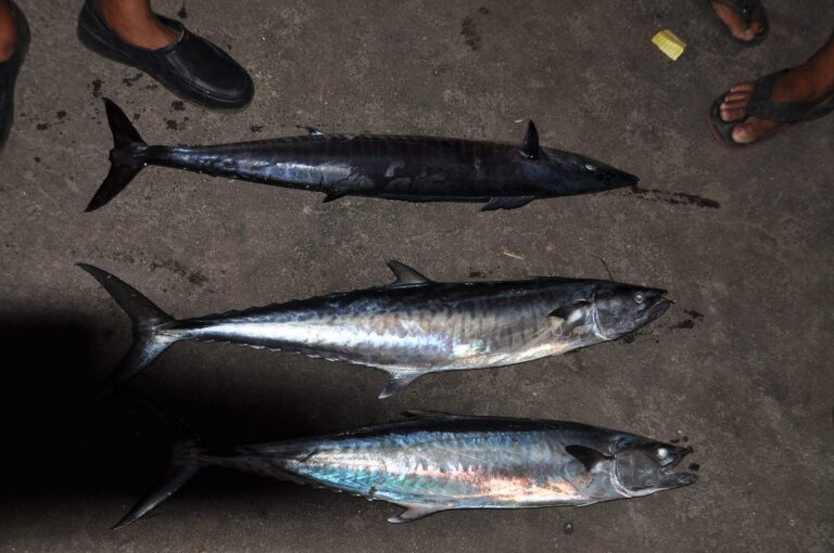
Photo: shankar s, CC BY 2.0
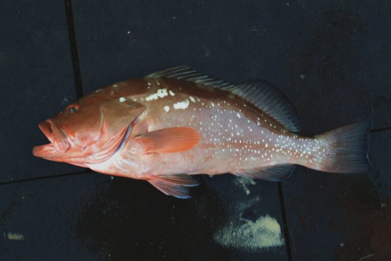
Photo: SEFSC Pascagoula Laboratory; Collection of Brandi Noble, NOAA/NMFS/SEFSC, Public domain

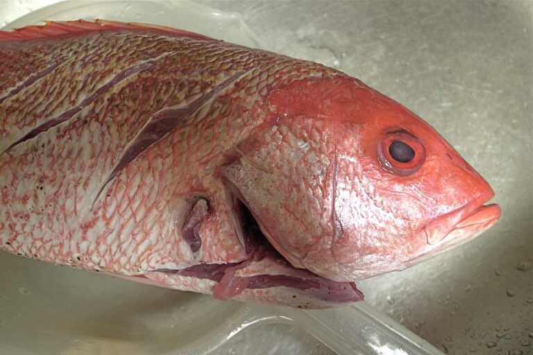
Photo: Naotake Murayama, CC BY 2.0
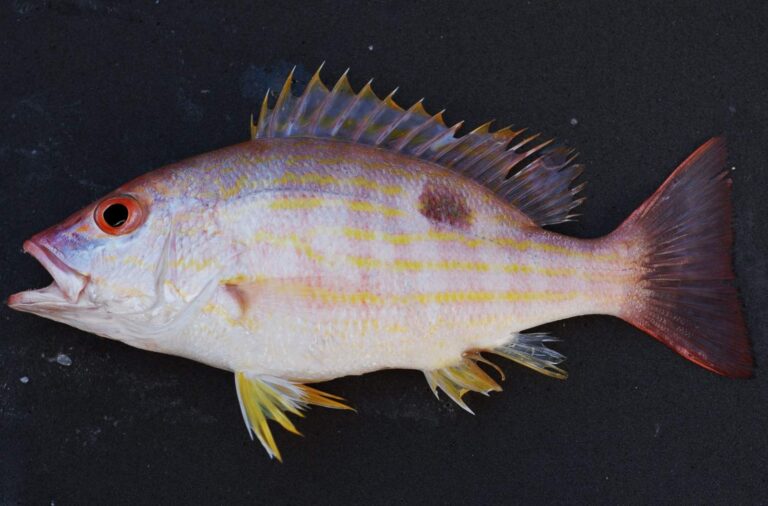
Photo: SEFSC Pascagoula Laboratory; Collection of Brandi Noble, NOAA/NMFS/SEFSC, CC BY 2.0

Before you fish Hugh Swingle, read these answers
How would I locate Hugh Swingle offshore?
The closest port is Fort Morgan, near 17 miles away.
How many sites sit in Hugh Swingle?
ADCNR lists 159 reefs across about 55,808 acres.
What is the listed depth at Hugh Swingle?
ADCNR lists 60 to 111 feet.
What are the reefs in Hugh Swingle made of?
Structure includes Pyramid (65), Bridge (44) and Tank (19).
What reef fish limits apply in Hugh Swingle?
Red snapper (private anglers, shore, state-licensed charter): opens May 22, 2026, closes not set (quota). Red Snapper: 2 per person in state and federal waters; 16" min. TL.
Do I need a reef fish endorsement at Hugh Swingle?
Saltwater anglers 16 and older carry an Alabama saltwater license ($30.90 resident, $66.80 nonresident for 2026-27), plus the $10 Gulf Reef Fish Endorsement to keep reef fish such as red snapper.
Is Hugh Swingle new structure?
1972 through 2025.
How reliable are the Hugh Swingle positions?
They come from the ADCNR master list and are for information only, not navigation.
What zone neighbours Hugh Swingle?
The closest is C.M. Blankenship, 5 miles off.
Fuel up for Hugh Swingle
Know the snapper season before the first drop.