Pass Drury Fishing
A pass of the Alabama coast in Mobile and Baldwin counties.
 Pick for redfishPiscifun Alloy S inshore spinning reelCheck price at Piscifun
Photo of Bayou La Batre: Mississippi-Alabama Sea Grant, CC BY 2.0
The short version on Pass Drury for salt water
In Mobile and Baldwin counties, Pass Drury is a pass on the Alabama coast. Plan on near 5 miles to Dauphin Island.
There are 4 public ramps serving it. Land-based anglers have 2 piers and bank sites. Visitors reach the water at 17 public access sites. Crews built 19 inshore reefs within 12 miles. 4 water level stations from NOAA sit close by.
USGS GNIS domestic names (feature class and primary point), read November 1, 2026; ADCNR coastal layers; Census 2023 places.
Coastal ramps that reach Pass Drury
- Billygoat Hole Ramp on Pass Druryramps: 4, docks: 5, ~45 parking spots, restrooms, Bienville Boulevard next to the Mobile Bay Ferry landing
- Ft. Morgan Boat Ramp on Pass Druryramps: 2 (double ramps), docks: 1 finger pier, 2 side piers, ~10 parking spots, restrooms, From HWY 59 in Gulf Shores, turn west onto HWY 180. …
- Landnier Landing on Pass Druryramps: 1, 35 parking spots, restrooms
- Little Billygoat Hole Ramp on Pass Druryramps: 2, docks: 3, ~30 parking spots, Bienville Boulevard across from Ft. Gaines and next …
Beach and bay access by Pass Drury
- Aloe Bay Landing1100 Desoto Avenue, Dauphin Island, MS Sound
- Audubon Bird Sanctuary213 Bienville Boulevard, Dauphin Island, MS Sound
- Bayou Heron ParkCorner of Cadillac Ave and Penalver Street, Dauphin Island, MS Sound
- Billy Goat Hole Ramps Alonzo Landing114 Bienville Boulevard, Dauphin Island, MS Sound
- Dauphin Island Campground109 Bienville Boulevard, Dauphin Island, MS Sound
- Dauphin Island East End Beach at East End LandingEast end of Bienville Boulevard, Dauphin Island, MS Sound
- Dauphin Island Public Beach and Fishing Pier (Dauphin Island Main Beach)1509 Bienville Boulevard, Dauphin Island, MS Sound
- Estuarium at Dauphin Island Sea Lab102 Bienville Boulevard, Dauphin Island, MS Sound
- Goat Tree ReserveCorner of Cadillac Avenue and Grant Street, Dauphin Island, MS Sound
- Historic Fort Gaines51 Bienville Boulevard, Dauphin Island, MS Sound
- Isle Dauphine Golf Club100 Orleans Drive, Dauphin Island, MS Sound
- Jefferies ParkEnd of Conti Street, Dauphin Island, MS Sound
- Little Billy Goat Hole Boat Launch at East End Landing51 Bienville Boulevard, Dauphin Island, MS Sound
- Mobile Bay Ferry Landing (Dauphin Island)112 Bienville Boulevard, Dauphin Island, MS Sound
- Penalver Park~1512 Cadillac Avenue, Dauphin Island, MS Sound
- Saw Grass PointBienville Boulevard, Dauphin Island, MS Sound
- Shell Mound ParkIberville Drive just north of Cadillac Avenue, Dauphin Island, MS Sound
More ADCNR ramps close to Pass Drury
- Jemison's Bait & Tackle boat ramp on Heron BayHeron Bay, 6 miles north
- Delta Port Marina on Heron BayHeron Bay, 9 miles northwest
- The Pines Boat Launch on Bon Secour BayBon Secour Bay, 12 miles east
- Fowl River Marina on Deer RiverDeer River, 13 miles north
- Bayou La Batre Boat LaunchBayou La Batre, 14 miles northwest
- Memories Fish Camp boat ramp on Deer RiverDeer River, 14 miles north
ADCNR coastal boating access pages and public access site layer (ADCNR GIS), read November 1, 2026; ADCNR WFF public boat ramp list (list), read November 1, 2026.
Walk-out fishing on Pass Drury
- Dauphin Island Public Beach and Fishing Pier (Dauphin Island Main Beach) on Pass Druryfishing pier, salt water, 1509 Bienville Boulevard, Dauphin Island
- Fort Morgan Fishing Pier and Boat Ramp on Pass Druryfishing pier, salt water, Fort Morgan Road (AL-180), 20.4 miles west …, Fort Morgan
Places to fish on foot near Pass Drury
- The Pines Fishing Pier and Boat Launch on Bon Secour Bayfishing pier, salt water, 12 miles
- Weeks Bay Boat Ramp and Pierfishing pier, salt water, 19 miles
- Pier Street Boat Ramp on Mobile Bayfishing pier, salt water, 21 miles
- Magnolia Springs Public Pierfishing pier, salt water, 21 miles
- Little Lagoon Pierfishing pier, salt water, 21 miles
ADCNR coastal boating access pages and public access site layer (ADCNR GIS), read November 1, 2026.
Reefs an easy run from Pass Drury
19 inshore reefs lie within 12 miles of Pass Drury; each row gives year, material and listed depth.
| Reef | Placed | Material | Listed depth | Distance |
|---|---|---|---|---|
| Lynn Dent Boykin Reef | 1999 | Concrete pipe and rubble and #2 limestone aggregate | 9 ft listed depth | under a mile north |
| Ghost Rig Reef | 2023 | 3367 tons of 3"x6" limestone aggregate (2023) | 1 mile east | |
| Ghost Rig Reef | 3367 tons of 3"x6" limestone aggregate was installed during 2023 | 1 mile east | ||
| CCA Alabama Pelican Bay Reef | 2017 | 80 eco-reef modules placed in clusters of 3-4 modules(each module consists of 3 … | 14 ft listed depth | 2 miles southwest |
| EXMOB 76-A | 2003 | 3" X 6" limestone aggregate placed around gas production platforms | 13 ft listed depth | 2 miles east |
| Wellhead Reef | 2023 | 3367 tons of 3"x6" limestone aggregate (2023) | 3 miles northeast | |
| Wellhead Reef | 3367 tons of 3"x6" limestone aggregate was installed during 2023 | 3 miles northeast | ||
| ExxonMobil: Alex Maisel Memorial Reef | 2003 | 3" X 6" limestone aggregate placed around gas production platforms | 13 ft listed depth | 4 miles northeast |
| Fort Morgan Barge | 2004 | Pilings placed around the perimeter of a sunken barge | 15 ft listed depth | 5 miles southeast |
| EXMOB 63-AB | 2003 | 3" X 6" limestone aggregate placed around gas production platforms | 12 ft listed depth | 6 miles east |
| LEGACY 615-1 | 2003 | 3" X 6" limestone aggregate placed around gas production platforms | 12 ft listed depth | 6 miles east |
| LEGACY 615-3 | 2003 | 3" X 6" limestone aggregate placed around gas production platforms | 12 ft listed depth | 7 miles east |
| LEGACY PLATFORM | 2003 | 3" X 6" limestone aggregate placed around gas production platforms | 10 ft listed depth | 7 miles east |
| LEGACY 615-4 | 2003 | 3" X 6" limestone aggregate placed around gas production platforms | 11 ft listed depth | 8 miles east |
ADCNR Marine Resources Division public reef master list 2025 (KMZ; reef layer), read November 1, 2026. Coordinates are for information only, not for navigation.
Watching the tide on Pass Drury
NOAA CO-OPS water level, preliminary reading at retrieval (November 1, 2026); station page for live data.
- Dauphin Island Hydrotide predictions, under a mile
- DAUPHIN ISLANDtide predictions, 1 mile
- Mobile Point (Fort Morgan)tide predictions, 5 miles
- West Fowl River, Hwy 188 bridgetide predictions, 9 miles
Predictions for Pass Drury are a guide; wind and runoff set the real level.
NOAA CO-OPS water level and tide prediction stations; read November 1, 2026.
Channels and passes close to Pass Drury
- The Cut5 miles southeast
- Little Pass Margaret2 miles northwest
- Pass Berron8 miles northwest
- Pass Chateaugue2 miles west
USGS GNIS domestic names (feature class and primary point), read November 1, 2026.
Harbors that serve Pass Drury
- Dauphin IslandMobile County, 1 mile
- Fort MorganBaldwin County, 5 miles
- Alabama PortMobile County, 7 miles
USGS GNIS domestic names (feature class and primary point), read November 1, 2026.
Inshore creel and size rules at Pass Drury
| Species | Daily limit and size | Waters |
|---|---|---|
| Sheepshead | 8 per person; 12" min. FL | state waters |
| Spotted Seatrout | 6 per person – one fish is allowed to be over; 15" min. TL – 22" max TL | state waters |
| Red Drum (Redfish) | 3 per person; 16" min. – 26" max TL | state waters |
| Cobia (Ling) | 1 per person, not to exceed 2 per vessel; 36" min. FL | state waters |
| Spanish Mackerel | 15 per person; no size limit | state waters |
| Florida Pompano | 3 per person; 12" min. TL | state waters |
| Striped Bass | 2 per person; 16" min TL | state waters |
| Flounder | 5 per person (Closed Season for the month of November); 14" min TL | state waters |
| Tripletail (Blackfish) | 3 per person; 18" min TL | state waters |
| Mullet | Oct. 24-Dec. 31, 25 mullet per person from the shoreline or 25 per boat. No mullet by cast net or snagging in Theodore Industrial Canal, Dog River, Fowl River, and their tributaries.; no siz | state waters |
Redfish, speckled trout and flounder rules for Pass Drury come first.
Which license applies follows the ADCNR line, printed on the saltwater page.
Saltwater anglers 16 and older carry an Alabama saltwater license ($30.90 resident, $66.80 nonresident for 2026-27), plus the $10 Gulf Reef Fish Endorsement to keep reef fish such as red snapper.
Limits as printed by the ADCNR Marine Resources Division recreational size, creel and possession limits for state waters (MRD limits page), read November 1, 2026.
 For the redfish herePiscifun NautiX saltwater spinning reel14% OFFSale $94.99
Where Pass Drury ranks along the Alabama coast
By access count, Mississippi Sound tops the table at 31.
| Water | Distance | Type | Ramps | Piers and banks | Access sites | Inshore reefs |
|---|---|---|---|---|---|---|
| Pass Drury | pass | 4 | 2 | 17 | 19 | |
| Pass aux Herons | 3 miles northwest | pass | 0 | 0 | 0 | 20 |
| Grants Pass | 3 miles northwest | pass | 0 | 0 | 0 | 20 |
| Heron Bay | 6 miles northwest | bay | 2 | 0 | 1 | 20 |
| Mississippi Sound | 8 miles northwest | sound | 8 | 1 | 23 | 14 |
| Portersville Bay | 11 miles northwest | bay | 0 | 0 | 1 | 10 |
ADCNR ramp, access and reef layers, USGS GNIS; read November 1, 2026.
Inland Alabama options behind Pass Drury
Neighbouring Alabama lakes to Pass Drury
- Shelby Lakes25 miles
- Big Creek Lake38 miles
- Dead Lake44 miles
Alabama rivers within easy reach of Pass Drury
- Fowl River12 miles
- Dog River24 miles
Tackle counters that serve Pass Drury
- Dockside Bait Shopbait and tackle shop, Dauphin Island, under a mile
- Dauphin Island Marinamarina, Dauphin Island, 2 miles
- Fort Morgan Marina Restaurantmarina, Gulf Shores, 6 miles
- Fowl River Marinabait and tackle shop, Theodore, 13 miles
- Fisherman's Discountbait and tackle shop, Fairhope, 17 miles
- Beachcomber Marina & Dry Dockmarina, Mobile, 21 miles
Paid trips on Pass Drury from our list
- AAA Charterscharter, Foley, (251) 948-2525
- Action Charter Service Inccharter, Orange Beach, (888) 558-3889
- Alabama Coastal Charterscharter, Gulf Shores, (251) 943-6017
- Alabama Deep Sea Fishingcharter, Lillian, (251) 981-3733
- Alabama Fun Fishing LLCcharter, Orange Beach, (251) 550-5002
- Alabama Inshore Charterscharter, Fairhope, (251) 421-6797
- Allen Stella Marina Charterscharter, Foley, (251) 981-4510
- Annan Brian Capt Gulf Rebelcharter, Orange Beach, (251) 981-3119
Alabama towns within a drive of Pass Drury
- Dauphin Island5 miles
- Bayou La Batre14 miles
- Theodore20 miles
- Grand Bay21 miles
Which county pages list Pass Drury
- Mobile Countyseat: Mobile
- Baldwin Countyseat: Bay Minette
Piscifun rods and reels lined up for Pass Drury


Piscifun and Amazon links are affiliate links; the site earns a commission on qualifying purchases.
Telling the Pass Drury fish apart, by photo
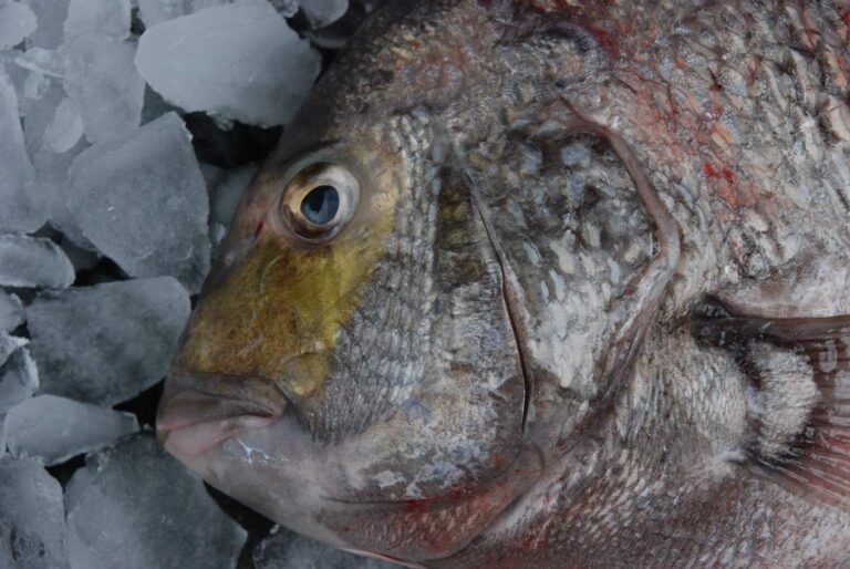
Photo: Louisiana Sea Grant College Program Louisiana State University, CC BY 2.0

Photo: Smithsonian Environmental Research Center, CC BY 2.0


Photo: Smithsonian Environmental Research Center, CC BY 2.0

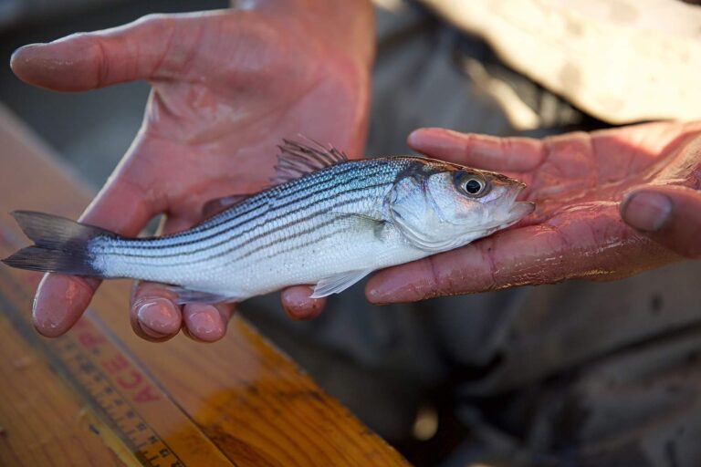
Photo: USFWS Pacific Southwest Region, Public domain
Pass Drury: answers for an Alabama fishing day
Where is Pass Drury?
Its named point falls in Mobile and Baldwin counties, about 5 miles from Dauphin Island.
Which license covers Pass Drury?
Saltwater anglers 16 and older carry an Alabama saltwater license ($30.90 resident, $66.80 nonresident for 2026-27), plus the $10 Gulf Reef Fish Endorsement to keep reef fish such as red snapper. The license line is quoted on the saltwater page.
How many ADCNR ramps reach Pass Drury?
Start at Billygoat Hole Ramp on Pass Drury; ADCNR lists 4 public ramps.
How many speckled trout may come home from Pass Drury?
Red Drum (Redfish): 3 per person; 16" min. – 26" max TL.
Where are tide predictions for Pass Drury?
Dauphin Island is the nearest NOAA water level station; its dated reading is in the tide band.
Can I wade Pass Drury?
Yes: 2 piers and bank sites, including Dauphin Island Public Beach and Fishing Pier (Dauphin Island Main Beach) on Pass Drury.
Which bait counter on our Alabama list serves Pass Drury?
Closest on our list: Dockside Bait Shop, under a mile away,.
Has ADCNR built reefs around Pass Drury?
19 inshore reefs, starting with Lynn Dent Boykin Reef.
Which Gulf passes lie near Pass Drury?
Nearby passes: The Cut, Little Pass Margaret, Pass Berron and Pass Chateaugue.
Plan a Gulf Coast run to Pass Drury
Get the Alabama saltwater license squared away online ahead of launch day.