Lake Superior Fishing
Michigan launches, harbors, bays, limits and charters on Lake Superior.
 Pick for lake troutPiscifun Carbon X ultralight spinning reel28% OFFSale $57.99
Photo: Tony Webster from Minneapolis, Minnesota, CC BY-SA 2.0
A first look at Lake Superior for anglers
Lake Superior is the largest, coldest and deepest of the Great Lakes, bordering the Upper Peninsula from Ironwood to Sault Ste. Marie. The catch here centers on lake trout, coho and Chinook salmon, whitefish and, in the bays, walleye and yellow perch.
Whole-lake EPA numbers run to 31,700 square miles of surface, 483 feet on average and 1,332 feet at most. Michigan counties on its shore include Alger County, Baraga County, Chippewa County, Gogebic County, Houghton County and Keweenaw County and others. This page counts 17 public launches, 19 harbors, 109 named bays, 171 river mouths and 3 charter listings on the Michigan side.
EPA Physical Features of the Great Lakes (whole lake), USGS GNIS, MDNR layers.
 For the lake trout herePiscifun Carbon XT ultralight spinning reel25% OFFSale $59.99
Where to launch on Lake Superior
Boat ramps reaching Lake Superior
- Burt Township Boat Access2 lanes, 16 trailer spaces, courtesy pier, toilet, fish cleaning station, Recreation Passport, Alger County
- Munising Municipal Boat Access4 lanes, 52 trailer spaces, courtesy pier, toilet, fish cleaning station, Recreation Passport, Alger County
- Arvon Township Park1 lane, courtesy pier, toilet, Baraga County
- Baraga State Parkboat ramp, toilet, Baraga County
- Baraga Village East Boat Access2 lanes, 4 trailer spaces, courtesy pier, toilet, fish cleaning station, Recreation Passport, Baraga County
- Baraga Village West Boat Access2 lanes, 15 trailer spaces, courtesy pier, Recreation Passport, Baraga County
- L'Anse Marina2 lanes, 21 trailer spaces, courtesy pier, fish cleaning station, Recreation Passport, Baraga County
- Tahquamenon Bay Boat Access1 lane, 2 trailer spaces, Recreation Passport, Chippewa County
- Whitefish Point State Harbor1 lane, 10 trailer spaces, courtesy pier, toilet, Recreation Passport, Chippewa County
- Grand Traverse Bay Harborboat ramp, toilet, Houghton County
- Stanton Township Parkboat ramp, Houghton County
- Copper Harbor State Harbor1 lane, 9 trailer spaces, courtesy pier, toilet, Recreation Passport, Keweenaw County
- Eagle Harbor State Harbor2 lanes, 20 trailer spaces, courtesy pier, toilet, Recreation Passport, Keweenaw County
- Big Bay Harbor1 lane, 9 trailer spaces, courtesy pier, toilet, Recreation Passport, Marquette County
- Cinder Pond Marina2 lanes, 22 trailer spaces, courtesy pier, fish cleaning station, Recreation Passport, Marquette County
- Presque Isle Marina2 lanes, 11 trailer spaces, courtesy pier, toilet, Recreation Passport, Marquette County
- Porcupine Mountains Wilderness State Park Union Bay2 lanes, courtesy pier, toilet, Recreation Passport, Ontonagon County
Harbors of refuge on Lake Superior
- Baraga Municipal MarinaBaraga County, grant in aid
- Big Bay Harbor Marquette County, grant in aid
- Black River (National Forest)Gogebic County, Federal
- Copper Harbor State HarborKeweenaw County, DNR managed (state owned)
- Eagle Harbor State HarborKeweenaw County, DNR managed (state owned)
- Grand Marais MarinaAlger County, grant in aid
- Grand Traverse Bay Schoolcraft Twp. MarinaHoughton County, grant in aid
- Hancock Houghton County MarinaHoughton County, grant in aid
- Houghton City MarinaHoughton County, grant in aid
- L'anse HarborBaraga County, grant in aid
- Lac La Belle State HarborKeweenaw County, DNR managed (state owned)
- Little Lake State HarborLuce County, DNR managed (state owned)
- Marquette Cinder Pond MarinaMarquette County, grant in aid
- Marquette Presque Isle MarinaMarquette County, grant in aid
- Munising Bayshore MarinaAlger County, grant in aid
- Ontonagon Village MarinaOntonagon County, grant in aid
- Rock HarborKeweenaw County, Federal
- Washington HarborKeweenaw County, Federal
- Whitefish Point State HarborChippewa County, DNR managed (state owned)
Fishing from shore on Lake Superior
- Grant Township, KeweenawShore, pier, boat, 24 hours a day, 7 days a week, fee: Yes, Rec Passport
MDNR boat access sites, MDNR harbors layer, MDNR fishing sites, checked October 2026.
Named bays along Lake Superior
- Bete Grise BayKeweenaw County
- Grand Traverse BayHoughton County
- Huron BayBaraga County
- Keweenaw BayBaraga County
- Little Traverse BayHoughton County
- Whitefish BayChippewa County
Smaller named bays: Agate Harbor, Amygdaloid Channel, Au Train Bay, Bay Furnace, Belle Harbor, Betsy Bay, Big Bay, Big Bay, Black River Harbor, Blueberry Cove, Brady Cove, Bryersund, Cat Harbor, Chippewa Harbor, Conglomerate Bay, Conway Bay, Copper Harbor, Crystal Cove, Dog Harbor, Dollar Bay, Duncan Bay, Eagle Harbor, East Bay, Echo Harbor, Finlander Bay, Fish Cove, Fishermans Bay, Fishermans Home Cove, Five Finger Bay, Florence Bay, Gilberts Hole, Grace Harbor, Grand Island Harbor Bay, Grand Marais Harbor, Great Sand Bay, Harbor of Refuge, Hay Bay, Herring Bay, High Rock Bay and Hopkins Harbor.
Mouths of rivers on Lake Superior
- Ankodosh CreekChippewa County
- Anna RiverAlger County
- Ash CreekOntonagon County
- Au Train RiverAlger County
- Bailey CreekKeweenaw County
- Bear Creek, Manistee CountyOntonagon County
- Beaver Creek, Houghton CountyAlger County
- Benson CreekKeweenaw County
- Bergman CreekChippewa County
- Big Betsy RiverKeweenaw County
- Big Iron RiverOntonagon County
- Big Siskiwit RiverKeweenaw County
- Black Creek, Muskegon CountyChippewa County
- Black Creek, Muskegon CountyKeweenaw County
- Black Creek, Muskegon CountyOntonagon County
- Black River, Sanilac CountyGogebic County
- Blind Sucker RiverLuce County
- Bobolink CreekGogebic County
- Boston CreekHoughton County
- Brewery CreekKeweenaw County
- Browns CreekChippewa County
- Cardinal CreekGogebic County
- Caribou CreekKeweenaw County
- Carp River, Mackinac CountyOntonagon County
- Carp River, Mackinac CountyMarquette County
- Carp River, Mackinac CountyLuce County
- Cedar Creek, Muskegon CountyKeweenaw County
- Chapel CreekAlger County
- Chickadee CreekGogebic County
- Chipmunk CreekAlger County
- Chocolay RiverMarquette County
- Cole CreekHoughton County
- Compeau CreekMarquette County
- Cranberry RiverOntonagon County
- Dead RiverMarquette County
- Dreiss CreekOntonagon County
- Duck Creek, Ionia CountyOntonagon County
- Eagle RiverKeweenaw County
- East Sleeping RiverOntonagon County
- Echo Lake CreekAlger County
- Eliza CreekKeweenaw County
- Elm RiverHoughton County
- Falls RiverBaraga County
- Firesteel RiverOntonagon County
- Flink CreekGogebic County
- Flintsteel RiverOntonagon County
- Floodwood RiverOntonagon County
- Galloway CreekChippewa County
- Garden City CreekKeweenaw County
- Gardeners CreekHoughton County
- Ghost CreekGogebic County
- Gijik CreekGogebic County
- Gipsy CreekGogebic County
- Gongeau CreekAlger County
- Grace CreekKeweenaw County
- Grant CreekChippewa County
- Gratiot RiverKeweenaw County
- Graveraet RiverHoughton County
- Gull Point CreekAlger County
- Gulskoog CreekBaraga County
- Halfaday CreekChippewa County
- Halfway CreekOntonagon County
- Harlow CreekMarquette County
- Hazel CreekBaraga County
- Hills CreekKeweenaw County
- Hoar CreekKeweenaw County
- Huron River, Washtenaw CountyBaraga County
- Hurricane RiverAlger County
- Ikwesens CreekGogebic County
- Iron RiverMarquette County
USGS GNIS bays and stream mouths assigned to the nearest Michigan Great Lakes assessment unit.
Water level on Lake Superior
US Army Corps of Engineers, Detroit District (CWMS) reading for Lake Superior (IGLD85), recorded October 21, 2026; retrieved October 22, 2026. Values are provisional.
NOAA CO-OPS Great Lakes water levels reading for Point Iroquois (IGLD85), recorded October 22, 2026; retrieved October 22, 2026. Values are provisional.
NOAA CO-OPS Great Lakes water levels reading for Marquette C.G. (IGLD85), recorded October 22, 2026; retrieved October 22, 2026. Values are provisional.
NOAA CO-OPS Great Lakes water levels reading for Ontonagon (IGLD85), recorded October 22, 2026; retrieved October 22, 2026. Values are provisional.
Size and bag limits on Lake Superior
| Species | Where | Limit | Season |
|---|---|---|---|
| Largemouth and smallmouth bass | All waters except Lake St. Clair, St. Clair River and Detroit River (and the Beaver Island Archipelago waters in Note 2) | 5 in any combination; minimum 14 inches | Possession: Sat. before Memorial Day – Dec. 31; catch-and-immediate-release open all year |
| Walleye | Upper Peninsula Great Lakes and inland waters, and St. Marys River | 5; minimum 15 inches | May 15 – March 15 |
| Walleye | Lower Peninsula Great Lakes (except as noted) | 5; minimum 15 inches | Open all year |
| Northern pike | Upper Peninsula Great Lakes and inland waters, and St. Marys River | 2; minimum 24 inches | May 15 – March 15 |
| Northern pike | Lower Peninsula Great Lakes, Lake St. Clair, St. Clair River and Detroit River | 2 (up to 5 pike 24 inches or greater on Lake St. Clair, St. Clair R. and Detroit R.) | Open all year |
| Flathead catfish | Statewide | 5; minimum 15 inches | Open all year |
| Channel catfish | Statewide | 10; minimum 12 inches | Open all year |
| Muskellunge (including tiger muskellunge) | All Great Lakes and inland waters and St. Marys River | Only 1 per angler per license year (April 1 – March 31); mandatory harvest registration within 24 hours; minimum 42 inches (46, 50 or 38 inches on listed waters | Possession: 1st Sat. in June – March 15; catch-and-immediate-release open all year |
| Yellow perch | Statewide (except as noted) | 25 | Open all year |
| Sunfishes (black and white crappie, bluegill, green and hybrid sunfish | Statewide | 25 in any combination of the listed species | Open all year |
| White bass | Great Lakes, Lake St. Clair, St. Marys River, St. Clair River and Detroit River | 25 | Open all year |
| Cisco, lake whitefish, round whitefish | Great Lakes, connecting waters and Type F lakes | 10 in any combination (Lake Superior: up to 10 additional round whitefish) | Open all year |
| Smelt | Statewide | 2 gallons | Open all year (see General Netting Regulations) |
| Burbot | Statewide | 5 | Open all year |
| All other species | Statewide (species not listed, not trout or salmon, not threatened or endangered) | No possession limit | Open all year |
| Trout and salmon (Atlantic, Chinook, coho and pink salmon; brook, brow | Great Lakes, Lake St. Clair, St. Marys River, St. Clair River and Detroit River | 5 total in any combination; no more than 3 of any one species, except up to 5 coho, Chinook or pink salmon. St. Marys River: 5 additional pink salmon from last | Open all year (lake trout and splake by management unit) |
| Brook trout | Lake Superior | 1; minimum 20 inches | Open all year |
| Lake trout and splake (combined) | Lake Superior management unit MI 1-3 (Windigo, Rock Harbor, Black River Harbor, Ontonagon, Upper Entry, Copper Harbor) | 3; minimum 15-inch minimum; no more than 1 lake trout 34 inches or greater | Open all year |
| Lake trout and splake (combined) | Lake Superior management unit MI 4-8 (Big Bay, Marquette, Au Train, Munising, Grand Marais, Keweenaw Bay, Whitefish Bay) | 5; minimum 15-inch minimum; no more than 1 lake trout 34 inches or greater | Open all year |
| Lake trout and splake (combined) | Lake Superior management unit Stannard Rock (MI-5) and Big Reef (MI-6) (Stannard Rock, Big Reef) | 1; minimum 15-inch minimum (new limit in 2026, see pp. 9, 20) | Open all year |
Lake trout seasons by unit, Lake Superior
| Unit | Ports | Season | Daily | Size |
|---|---|---|---|---|
| MI 1-3 | Windigo, Rock Harbor, Black River Harbor, Ontonagon, Upper Entry, Copper Harbor | Open all year | 3 | 15-inch minimum; no more than 1 lake trout 34 inches or greater |
| MI 4-8 | Big Bay, Marquette, Au Train, Munising, Grand Marais, Keweenaw Bay, Whitefish Bay | Open all year | 5 | 15-inch minimum; no more than 1 lake trout 34 inches or greater |
| Stannard Rock (MI-5) and Big Reef (MI-6) | Stannard Rock, Big Reef | Open all year | 1 | 15-inch minimum (new limit in 2026, see pp. 9, 20) |
Lake trout refuges on file: Lake Superior (Big Reef) and Lake Superior (Stannard Rock).
MDNR statistical districts on Lake Superior: MI-1, MI-2, MI-3, MI-4, MI-5, MI-6, MI-7 and MI-8.
One Michigan all-species license covers the Great Lakes and connecting waters too: $26 a year for residents, $76 for nonresidents or $10 for a single day.
2026 Michigan Fishing Regulations (April 1, 2026 to March 31, 2027), Great Lakes and connecting waters tables. All Michigan limits.
Fish planted in Lake Superior
MDNR and partner crews planted Lake Superior 28 times from 2024 to 2026, 588,937 fish.
| Species | Plants | Fish |
|---|---|---|
| Walleye | 4 | 321,068 |
| Splake | 13 | 192,909 |
| Lake trout | 8 | 44,410 |
| Brook trout | 2 | 15,575 |
| Rainbow trout | 1 | 14,975 |
Recent releases into Lake Superior
| Date | Species | Strain | Avg length | Number |
|---|---|---|---|---|
| May 8, 2026 | Splake | Hybrid | 20.5 in | 7,568 |
| May 8, 2026 | Splake | Hybrid | 20.2 in | 17,987 |
| May 7, 2026 | Splake | Hybrid | 20.2 in | 20,395 |
| May 5, 2026 | Splake | Hybrid | 20.7 in | 20,396 |
| June 18, 2025 | Lake trout | Huron Island | 22.3 in | 100 |
| June 18, 2025 | Lake trout | Huron Island | 18 in | 2,635 |
| June 16, 2025 | Lake trout | Huron Island | 19.4 in | 2,000 |
| June 12, 2025 | Lake trout | Huron Island | 22.3 in | 1,385 |
| June 12, 2025 | Lake trout | Huron Island | 19.1 in | 2,000 |
| May 9, 2025 | Splake | Hybrid | 20.5 in | 9,807 |
MDNR Fish Stocking Report table (state, federal and tribal plants), January 2024 to October 2026.
Hiring a guide for Lake Superior
- Shelter Bay Charterscharter, Au Train, (906) 892-8230
- Voyager Charterscharter, Bruce Crossing, (906) 827-3466
- Blue Heron Charterscharter, Sault Sainte Marie, (906) 635-5134
Marinas near Lake Superior
- Ojibwa Campground & MarinaBaraga
- Markham's MarinaHoughton
- Ensign SparsMarquette
- Dollar Bay MotorsportsOsceola Twp
- All Star Marine And Power SportsSault Sainte Marie
- C H Marine ServicesSault Sainte Marie
- George Kemp MarinaSault Sainte Marie
- Witz MarinaSkanee
Yellow Pages listings; charters matched by name or shore county.
Michigan big water other than Lake Superior
- Lake Michigangreat lake
- Lake Hurongreat lake
- Lake Eriegreat lake
- Lake St. Clairconnecting water
- St. Marys Riverconnecting water
- St. Clair Riverconnecting water
- Detroit Riverconnecting water
Piscifun spinning and baitcasting picks for Lake Superior


Piscifun and Amazon links are affiliate links; the site earns a commission on qualifying purchases.
Identifying the fish of Lake Superior
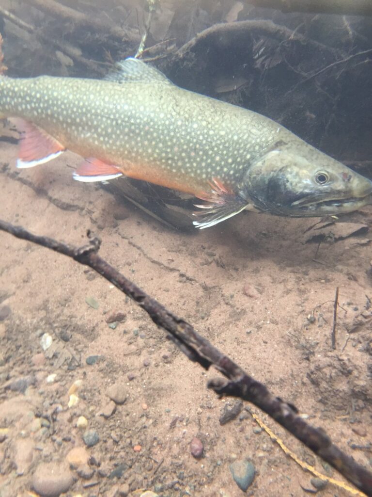
Photo: USFWS Midwest Region, Public domain

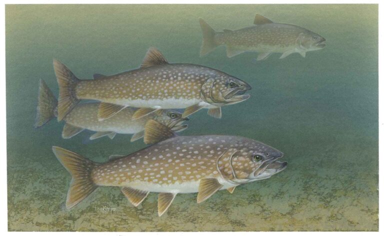
Photo: Knepp Timothy, U.S. Fish and Wildlife Service, Public domain

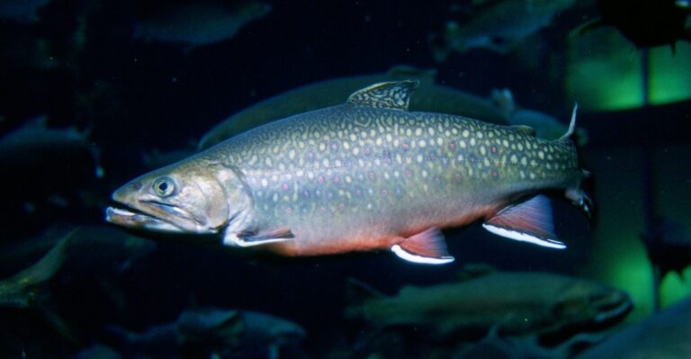
Photo: Engbretson, Eric, Public domain

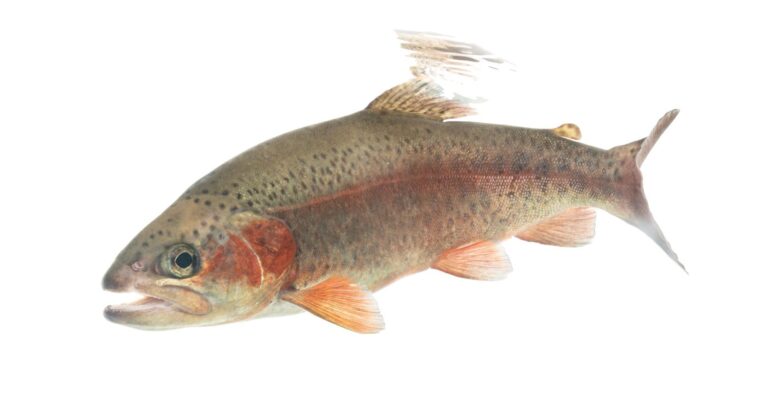
Photo: USFWS Mountain Prairie, Public domain

Fishing Lake Superior: quick answers
Which license covers Lake Superior?
One Michigan all-species license covers the Great Lakes and connecting waters too: $26 a year for residents, $76 for nonresidents or $10 for a single day.
How many launches reach Lake Superior from Michigan?
17 public launches and 19 harbors are listed on this page, busiest counties Baraga and Marquette.
What fish do anglers catch in Lake Superior?
Lake trout, coho and Chinook salmon, whitefish and, in the bays, walleye and yellow perch.
Which rivers flow into Lake Superior?
171 stream mouths are listed, among them Ankodosh Creek, Anna River and Ash Creek.
Is a Michigan charter boat available for Lake Superior?
3 charter listings, mostly out of Au Train, Bruce Crossing and Sault Sainte Marie.
What is the walleye limit on Lake Superior?
See the limit table above; the statewide Great Lakes rows apply.
Where can I check the water level of Lake Superior?
4 level stations on this page show dated readings from NOAA or the Corps of Engineers.
Has the MDNR stocked Lake Superior recently?
28 plants from 2024 to 2026 are on file, mostly splake, lake trout and walleye.
What lake trout bag applies on Lake Superior?
It depends on the unit: MI 1-3 3 a day (open all year); MI 4-8 5 a day (open all year); Stannard Rock (MI-5) and Big Reef (MI-6) 1 a day (open all year).
Plan a Michigan trip to Lake Superior
Pick a launch above and check the unit limits first.