Fishing in Cowlitz County, Washington
County seat: Kelso. Population 110,730.
- 10lake pages
- 14launches
- 12river pages
 Pick for salmonPiscifun Viper X spinning reel50% OFFSale $39.99
Photo of Lake Merwin: Jesse Keating, CC BY-SA 2.0
Cowlitz County laid out lake by lake for anglers
With 110,730 residents at the 2020 Census, Cowlitz County keeps its county offices in Kelso. WDFW records the 2026 plantings for this county under WDFW Region 5. Anglers on Columbia River fish a border water. The backcountry holds 2 lakes on the WDFW high lakes list.
Biggest among 10 lake pages is Lake Merwin, and the set spans 10,431 acres. SWIFD lines put salmon or steelhead in Cowlitz River, Lewis River, Kalama River and Toutle River. The WDFW and State Parks layers map 14 boat launches in the county (11 WDFW and 3 other agencies). Shore anglers have 23 shore or access sites on WDFW maps, piers among them at 7.
Census 2020 population; WDFW Fish Washington lake layers, WDFW facilities and State Parks launch layers (WDFW GIS); WDFW marine areas; retrieved October 31, 2026.
 For the salmon herePiscifun AlumiX spinning reel46% OFFSale $64.99
Ramps, piers and lakes of Cowlitz County on one map
WDFW and State Parks launch layers, WDFW facilities, WDFW lake points, NHD river midpoints and WDFW marine area points. Checked November 2026.
The paged lakes and reservoirs of Cowlitz County
| Lake | Acres | Launches | WDFW program | Fish WDFW maps |
|---|---|---|---|---|
| Lake Merwin | 3,836 | 0 | Mixed species – Trout emphasis | kokanee, tiger muskie, rainbow trout |
| Yale Reservoir | 3,612 | 0 | Trout emphasis | coastal cutthroat trout, kokanee |
| Silver Lake (Cowlitz County) | 1,424 | 1 | Mixed species – Warmwater emphasis | rainbow trout, largemouth bass, brown bullhead |
| Coldwater Lake | 773 | 0 | Trout emphasis | rainbow trout |
| Merrill Lake | 283 | 0 | Trout emphasis | rainbow trout, brown trout, brook trout |
| Castle Lake | 258 | 0 | Trout emphasis | rainbow trout |
| Swift Power Canal | 91 | 0 | Trout emphasis | rainbow trout, coastal cutthroat trout |
| Horseshoe Lake (Cowlitz County) | 83 | 0 | Mixed species – Trout emphasis | rainbow trout, brown trout, largemouth bass |
| Lake Sacajawea | 46 | 0 | Mixed species – Trout emphasis | rainbow trout, largemouth bass, brown bullhead |
| Kress Lake | 25 | 1 | Mixed species – Trout emphasis | rainbow trout, largemouth bass, brown bullhead |
WDFW Fish Washington lowland and high lake layers (surface acres as published, management emphasis, mapped species); WDFW publishes no lake depths in these layers. Retrieved October 31, 2026.
Species by number of waters close to Cowlitz County
Bars count the lake and regional marine pages within 50 miles of Kelso that list each fish in WDFW layers, records or trout plants; rainbow trout tops the count.
Species mapped in the WDFW Fish Washington layers, WDFW state records and the 2026 WDFW trout plants, counted per water page within 50 miles; not a survey.
Further WDFW-mapped lakes of Cowlitz County
2 further lakes of Cowlitz County, many of them high lakes, stay on this list until more is published.
| Water | Acres | WDFW program | Nearest town |
|---|---|---|---|
| Coweeman Lake | 5 | WDFW high lake, fish stocking | Amboy |
| Lakeview Peak Lake | 3 | WDFW high lake, fish stocking | Amboy |
WDFW Fish Washington lowland and high lake layers and USGS NHD lake outlines, retrieved October 31, 2026.
River guides that cross Cowlitz County
- Cowlitz RiverSWIFD lists chinook, chum and coho, 2 mapped launches, 10 WDFW shore or access sites, 5 USGS gauges, 127 mi in Washington
- Lewis RiverSWIFD lists chinook, chum and coho, 2 mapped launches, 3 WDFW shore or access sites, 3 USGS gauges, 91 mi in Washington
- Kalama RiverSWIFD lists chinook, chum and coho, 6 mapped launches, 2 WDFW shore or access sites, 45 mi in Washington
- Toutle RiverSWIFD lists chinook, chum and coho, 1 mapped launch, 2 WDFW shore or access sites, 1 USGS gauge, 16 mi in Washington
- Columbia RiverSWIFD lists chinook, chum and coho, 8 WDFW shore or access sites, 6 USGS gauges, 728 mi in Washington
- Green River (Cowlitz County)SWIFD lists chinook, chum and coho, 37 mi in Washington
- North Fork Toutle RiverSWIFD lists chinook, chum and coho, 1 USGS gauge, 37 mi in Washington
- Coweeman RiverSWIFD lists chinook, chum and coho, 37 mi in Washington
- South Fork Chehalis RiverSWIFD lists chinook, coho and steelhead trout, 1 USGS gauge, 34 mi in Washington
- South Fork Toutle RiverSWIFD lists chinook, chum and coho, 1 WDFW shore or access site, 32 mi in Washington
- Olequa Creek2 mapped launches, 19 mi in Washington
- Abernethy Creek1 WDFW shore or access site, 11 mi in Washington
Smaller Cowlitz County streams without a page (3)
- East Fork Elochoman RiverSWIFD lists chinook, coho and steelhead trout, 6 mi in Washington
- Little Kalama RiverSWIFD lists chinook and steelhead trout, 5 mi in Washington
- North Fork Kalama RiverSWIFD lists chinook and steelhead trout, 7 mi in Washington
USGS discharge figures for Cowlitz County streams
| USGS gauge | Latest reading | Time (ET) |
|---|---|---|
| Cowlitz River At Castle Rock, Wa | 5,000 cfs, 34.04 ft gage height | Nov 11 5:30 pm |
| Toutle River At Tower Road Near Silver Lake, Wa | 1,090 cfs, 121.25 ft gage height | Nov 11 5:45 pm |
| Nf Toutle River Below Srs Near Kid Valley, Wa | 403 cfs, 33.19 ft gage height | Nov 11 6:00 pm |
| Speelyai Creek Near Cougar, Wa | 45 cfs, 4.27 ft gage height | Nov 11 5:15 pm |
US Geological Survey provisional data, retrieved Nov 11, 2026 6:33 pm ET. Provisional readings can be revised.
USGS NHD flowlines and Washington lengths, WDFW SWIFD salmon and steelhead distribution, WDFW and State Parks launches, USGS gauges; retrieved October 31, 2026.
What WDFW planted across Cowlitz County this year
Hatchery trucks made 24 stops in Cowlitz County during 2026, leaving 56,333 fish in 5 waters.
- Lake MerwinRainbow, 1,647 fish at 0.3 per pound, July 13, 2026, Merwin Hatchery
- Lake MerwinRainbow, 3,464 fish at 0.7 per pound, July 13, 2026, Merwin Hatchery
- Horseshoe Lake (Cowlitz County)Rainbow, 72 fish at 0.12 per pound, May 15, 2026, Goldendale Hatchery
- Horseshoe Lake (Cowlitz County)Rainbow, 30 fish at 0.33 per pound, May 15, 2026, Goldendale Hatchery
- Horseshoe Lake (Cowlitz County)Rainbow, 2,500 fish at 2.5 per pound, May 15, 2026, Goldendale Hatchery
- Lake SacajaweaBrown Trout, 2,700 fish at 2.7 per pound, May 6, 2026, Mossyrock Hatchery
- Kress LakeBrown Trout, 2,700 fish at 2.7 per pound, May 6, 2026, Mossyrock Hatchery
- Horseshoe Lake (Cowlitz County)Brown Trout, 3,240 fish at 2.7 per pound, May 5, 2026, Mossyrock Hatchery
- Lake SacajaweaRainbow, 30 fish at 0.13 per pound, April 24, 2026, Goldendale Hatchery
- Lake SacajaweaRainbow, 50 fish at 0.33 per pound, April 24, 2026, Goldendale Hatchery
- Lake SacajaweaRainbow, 3,500 fish at 2.5 per pound, April 24, 2026, Mossyrock Hatchery
- Lake SacajaweaRainbow, 3,640 fish at 2.6 per pound, April 21, 2026, Mossyrock Hatchery
WDFW Trout Plants report (rows January 2 to October 27, 2026), read October 31, 2026; newest plants first.
Mapped water access throughout Cowlitz County
- Fisherman's Loop boat launch on Kalama RiverKalama River, WDFW, 1 ramp, concrete surface, Discover Pass
- Hand boat launch on Kalama RiverKalama River, WDFW, 1 ramp, concrete surface, Discover Pass
- Island boat launch on Lewis RiverLewis River, PacifiCorp, 1 ramp, concrete surface
- Kress Lake boat launchKress Lake, WDFW, 1 ramp, concrete surface, Discover Pass
- Modrow Bridge boat launch on Kalama RiverKalama River, WDFW, 1 ramp, concrete surface, Discover Pass
- Pekin Ferry boat launch on Lewis RiverLewis River, WDFW, 1 ramp, concrete surface, Discover Pass
- Silver Lake boat launch (west)Silver Lake, WDFW, 1 ramp, concrete surface, Discover Pass
- Sportsman's Club boat launch on Kalama RiverKalama River, WDFW, 1 ramp, unimproved surface surface, Discover Pass
- Woodland Bar boat launchlaunch site, WDFW, 1 ramp, unimproved surface surface, Discover Pass
- Lower Kalama boat launchKalama River, agency not given, gravel surface
- Olequa Creek boat launchOlequa Creek, WDFW, concrete surface, Discover Pass
- Olequa Crossing boat launchOlequa Creek, agency not given, concrete surface
- Prichard boat launch on Kalama RiverKalama River, WDFW, 1 hand launch, Discover Pass
- Tower Bridge boat launch on Toutle RiverToutle River, WDFW, 1 hand launch, Discover Pass
The layers flag 11 of these launches as needing a Discover Pass on the vehicle.
Shore sites and piers in Cowlitz County (23)
- Beginners' Hole on Kalama Riverwater access area
- Mouth of Toutlewater access area
- Abernathy Creek on Abernethy Creekaccess point (no launch)
- Cowlitz Anglersaccess point (no launch)
- Fisher Islandaccess point (no launch)
- Fisherman's Loop (east) on Kalama Riveraccess point (no launch)
- Fishing pierfishing pier
- Fishing pierfishing pier
- Fishing pierfishing pier
- Fishing pierfishing pier
- Gardner on South Fork Toutle Riveraccess point (no launch)
- Greene on Toutle Riveraccess point (no launch)
- Horseshoe Lake shore accessshore fishing site, Boat ramp, 430 feet of shoreline west of the ramp and 800 fe
- Horseshoe Lake shore accessshore fishing site, 500 feet of shoreline on the west end of the lake
- Kress Lake shore accessshore fishing site, One-mile trail around lake leads to openings that you can wa
- Lake Sacajawea shore accessshore fishing site, Three miles of trail surround the entire lake, shore fishing
- Merwin Reservoir fishing piershore fishing site, Shore fishing east and west of boat ramp, includes a swim ar
- Merwin Reservoir shore accessshore fishing site, 600 feet of shore fishing, includes a swim area during summe
- Merwin Reservoir shore access near Amboyshore fishing site, 300 feet of shore fishing north and south of the boat ramp
- Silver Lake fishing pierfishing pier
- Silver Lake fishing piershore fishing site, Boat ramp and fishing dock
- Silver Lake shore accessshore fishing site, 1000 feet of open shoreline along HWY 504, parking limited
- Yale Reservoir shore accessshore fishing site, 1200 feet of shore fishing south of the ramp, 700 feet north
WDFW Facilities layer (boat launches, piers, shore sites) and the State Parks boat launch layer; retrieved October 31, 2026. Lanes and per-launch fees are not published in these layers.
Staying inside the limits in Cowlitz County
Statewide freshwater limits hold across Cowlitz County wherever WDFW prints no water-specific rule. For lakes and rivers the Freshwater license costs $39.95 with Washington residency, $115.85 without it. WDFW adds a catch record card for anyone keeping salmon, steelhead, sturgeon or halibut.
| Species | Limit | Season |
|---|---|---|
| Largemouth Bass | No min. size in lakes, ponds, and reservoirs. Only largemouth bass less than 12" may be retained, except 1 over 17" may be retained. Daily limit 5. | Lakes, ponds, and reservoirs: year-round; rivers, streams and beaver ponds: Sat. before Memorial Day through Oct. 31 |
| Largemouth Bass | No size restriction/daily limit in rivers, streams, and beaver ponds. | Lakes, ponds, and reservoirs: year-round; rivers, streams and beaver ponds: Sat. before Memorial Day through Oct. 31 |
| Smallmouth Bass | No min. size in lakes, ponds, and reservoirs. Only 1 smallmouth bass over 14" may be retained. Daily limit 10. | Lakes, ponds, and reservoirs: year-round; rivers, streams and beaver ponds: Sat. before Memorial Day through Oct. 31 |
| Smallmouth Bass | No size restriction/daily limit in rivers, streams, and beaver ponds. | Lakes, ponds, and reservoirs: year-round; rivers, streams and beaver ponds: Sat. before Memorial Day through Oct. 31 |
| Walleye | Min. size 12" in lakes, ponds, and reservoirs. Daily limit 8. Only 1 over 22" may be retained. May be caught, retained, and released alive from a livewell until daily limit is in possession. | Lakes, ponds, and reservoirs: year-round; rivers, streams and beaver ponds: Sat. before Memorial Day through Oct. 31 |
| Walleye | No size restriction/daily limit in rivers, streams, and beaver ponds. | Lakes, ponds, and reservoirs: year-round; rivers, streams and beaver ponds: Sat. before Memorial Day through Oct. 31 |
| Channel Catfish | No min. size in lakes, ponds, and reservoirs. Daily limit 5. | Lakes, ponds, and reservoirs: year-round; rivers, streams and beaver ponds: Sat. before Memorial Day through Oct. 31 |
| Channel Catfish | No min. size/daily limit in rivers, streams, and beaver ponds. | Lakes, ponds, and reservoirs: year-round; rivers, streams and beaver ponds: Sat. before Memorial Day through Oct. 31 |
| Burbot (Freshwater Ling) | No min. size. Daily limit 5. | Lakes, ponds, and reservoirs: year-round; rivers, streams and beaver ponds: Sat. before Memorial Day through Oct. 31 (p.23 general rule for |
| Crappie, Northern Pikeminnow, Peamouth Chub, Perch, Suckers, Sunfish, | No min. size. No daily limit. | Lakes, ponds, and reservoirs: year-round; rivers, streams and beaver ponds: Sat. before Memorial Day through Oct. 31 |
| Grass Carp | Closed unless otherwise listed in Special Rules. | Closed |
| Kokanee | No min. size. Daily limit 10. When fishing with bait, all kokanee that are lawful to possess and are equal to or greater than the minimum size are counted as part of the daily limit whether kept or released. | Lakes, ponds, and reservoirs: year-round; rivers, streams and beaver ponds: Sat. before Memorial Day through Oct. 31 (p.23 general rule for |
| Tiger Muskellunge (Tiger Muskie) | Min. size 50". Daily limit 1. | Lakes, ponds, and reservoirs: year-round; rivers, streams and beaver ponds: Sat. before Memorial Day through Oct. 31 (p.23 general rule for |
| Whitefish | No min. size. Daily limit 15. | Lakes, ponds, and reservoirs: year-round; rivers, streams and beaver ponds: Sat. before Memorial Day through Oct. 31 (p.23 general rule for |
| Steelhead | Release all wild steelhead. Min. size 20". Daily limit 2. Open during salmon or game fish seasons unless as otherwise listed. | Open during salmon or game fish seasons unless as otherwise listed |
| Brown Trout, Cutthroat Trout, Rainbow Trout, Golden Trout, Tiger Trout | In rivers, streams, and beaver ponds: Min. size 8". Daily limit 2. | Sat. before Memorial Day-Oct. 31 (statewide river season, p.23) |
Cowlitz County waters printed with their own rules (965)
| Water and reach | Species | Rule |
|---|---|---|
| Abernathy Creek: from mouth (Hwy. 4 bridge) to 500’ below Abernathy Fish Technology Center and all tributaries CRC (501) | All species | Columbia River Salmon and Steelhead Endorsement (CRSSE) required for salmon and steelhead fishing (ages 15 and older). Selective gear rules, except barbed hooks are allowed. |
| Abernathy Creek: from mouth (Hwy. 4 bridge) to 500’ below Abernathy Fish Technology Center and all tributaries CRC (501) | Trout | Min. size 14”. Daily limit 2. (Sat. before Memorial Day-Aug. 31) |
| Abernathy Creek: from mouth (Hwy. 4 bridge) to 500’ below Abernathy Fish Technology Center and all tributaries CRC (501) | Trout | Min. size 14”. Daily limit 2. (Nov. 1-Mar. 15) |
| Abernathy Creek: from mouth (Hwy. 4 bridge) to 500’ below Abernathy Fish Technology Center and all tributaries CRC (501) | Steelhead (hatchery) | Min. size 20”. Daily limit 3. (Sat. before Memorial Day-Aug. 31) |
| Abernathy Creek: from mouth (Hwy. 4 bridge) to 500’ below Abernathy Fish Technology Center and all tributaries CRC (501) | Steelhead (hatchery) | Min. size 20”. Daily limit 3. (Nov. 1-Mar. 15) |
| Abernathy Creek: from mouth (Hwy. 4 bridge) to 500’ below Abernathy Fish Technology Center and all tributaries CRC (501) | Other game fish | Statewide min. size/daily limit. (Sat. before Memorial Day-Aug. 31) |
| Abernathy Creek: from mouth (Hwy. 4 bridge) to 500’ below Abernathy Fish Technology Center and all tributaries CRC (501) | Other game fish | Statewide min. size/daily limit. (Nov. 1-Mar. 15) |
| Abernathy Creek: from mouth (Hwy. 4 bridge) to 500’ below Abernathy Fish Technology Center and all tributaries CRC (501) | Salmon | Min. size 12”. Daily limit 6 including no more than 2 adults. Release all salmon other than hatchery Chinook and hatchery coho. (Nov. 1-Dec. 31) |
| Abernathy Creek: from 500’ below Abernathy Fish Technology Center to 200’ above Abernathy falls and all tributaries | All species | CLOSED WATERS. |
| Abernathy Creek: from 200’ above Abernathy Falls upstream and all tributaries CRC (501) | All species | Columbia River Salmon and Steelhead Endorsement (CRSSE) required for salmon and steelhead fishing (ages 15 and older). Selective gear rules, except barbed hooks are allowed. |
| Abernathy Creek: from 200’ above Abernathy Falls upstream and all tributaries CRC (501) | Trout | Min. size 14”. Daily limit 2. (Sat. before Memorial Day-Aug. 31) |
| Abernathy Creek: from 200’ above Abernathy Falls upstream and all tributaries CRC (501) | Trout | Min. size 14”. Daily limit 2. (Nov. 1-Mar. 15) |
| Abernathy Creek: from 200’ above Abernathy Falls upstream and all tributaries CRC (501) | Steelhead (hatchery) | Min. size 20”. Daily limit 3. (Sat. before Memorial Day-Aug. 31) |
| Abernathy Creek: from 200’ above Abernathy Falls upstream and all tributaries CRC (501) | Steelhead (hatchery) | Min. size 20”. Daily limit 3. (Nov. 1-Mar. 15) |
| Abernathy Creek: from 200’ above Abernathy Falls upstream and all tributaries CRC (501) | Other game fish | Statewide min. size/daily limit. (Sat. before Memorial Day-Aug. 31) |
| Abernathy Creek: from 200’ above Abernathy Falls upstream and all tributaries CRC (501) | Other game fish | Statewide min. size/daily limit. (Nov. 1-Mar. 15) |
| Abernathy Creek: from 200’ above Abernathy Falls upstream and all tributaries CRC (501) | Salmon | Min. size 12”. Daily limit 6 including no more than 2 adults. Release all salmon other than hatchery Chinook and hatchery coho. (Nov. 1-Dec. 31) |
| Coal Creek: from mouth to 400’ downstream of falls CRC (517) | All species | Selective gear rules, except barbed hooks are allowed. Columbia River Salmon and Steelhead Endorsement (CRSSE) required for salmon and steelhead fishing (ages 15 and older). |
| Coal Creek: from mouth to 400’ downstream of falls CRC (517) | Trout | Min. size 14”. Daily limit 2. (Sat. before Memorial Day-Aug. 31) |
| Coal Creek: from mouth to 400’ downstream of falls CRC (517) | Trout | Min. size 14”. Daily limit 2. (Nov. 1-Mar. 15) |
Limits and seasons as printed in the 2026-2027 Washington Sport Fishing Rules (WDFW pamphlet, in effect July 1, 2026 to June 30, 2027), PDF page 27 (pamphlet PDF; eRegulations statewide freshwater page), read October 31, 2026. Special Rules as printed in the 2026-2027 Washington Sport Fishing Rules (WDFW pamphlet, in effect July 1, 2026 to June 30, 2027), pamphlet page 48 (pamphlet PDF), read on eRegulations October 31, 2026.
Record-book catches credited to Cowlitz County water
| Species | Weight | Angler | Water | Date |
|---|---|---|---|---|
| Warmouth | 0.53 lbs | Linda Hatlelid | Silver Lake (Cowlitz County) | May 27, 1996 |
| Smallmouth Bass | 8.75 lbs | Ray Wonacott | Columbia River | April 23, 1966 |
| Blue Catfish | 17.75 lbs | Rangle Hawthorne | Columbia River | July 9, 1975 |
| Peamouth | 1.48 lbs | Michael Lane | Columbia River | May 10, 2026 |
| American Shad | 3.85 lbs | Tom Magnuson | Columbia River | June 21, 2005 |
| Largescale Sucker | 8.96 lbs | Kimo Gabriel | Columbia River | March 21, 2026 |
| Mountain Whitefish | 5.13 lbs | Steven Becken | Columbia River | Nov. 30, 1983 |
Washington Department of Fish and Wildlife (WDFW) sport fish records list, as of October 31, 2026.
Where Cowlitz County anglers restock
Cowlitz County fly shops and bait counters
- Black Heron Fly Fishingfly shop, Longview
- Bob's Sporting Goodsbait and tackle shop, Longview
- Harpers Tackle & Outdoorbait and tackle shop, Woodland
- Metro Tackle & Morebait and tackle shop, Kelso
- River Creek Rodsbait and tackle shop, Woodland
- Targus Fly and Featherbait and tackle shop, Woodland
- Port of Kalamamarina, Kalama
- Sportsman's Warehouse Kelsosporting goods store, Kelso
Guided trips listed for Cowlitz County
- Columbia River Fishing Slayerfishing guide, Castle Rock, (360) 270-0641
Yellow Pages and chain store listings, guide and charter listings (city of business); retrieved October 31, 2026.
Roads leading away from Cowlitz County
Fishing town guides within Cowlitz County
- Longviewpop. 37,818
- Kelsopop. 12,720
- Woodlandpop. 6,531
- Longview Heightspop. 4,033
- Lexingtonpop. 3,834
- Kalamapop. 2,959
- Castle Rockpop. 2,446
- Beacon Hillpop. 2,211
Adjoining county guides for Cowlitz County
- Lewis County30 miles northeast
- Clark County31 miles south
- Wahkiakum County36 miles west
- Skamania County37 miles east
Piscifun reels and line rigged for Cowlitz County


Piscifun and Amazon links are affiliate links; the site earns a commission on qualifying purchases.
Fish worth recognising before a day at Cowlitz County
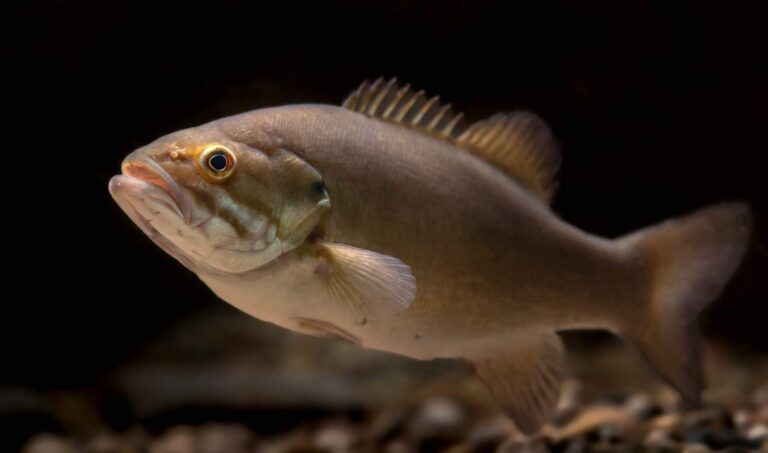
Photo: USFWS Mountain-Prairie, Public domain

Photo: Oregon Department of Fish & Wildlife, CC BY-SA 2.0
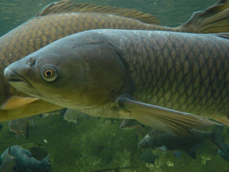
Photo: Pengo, CC BY-SA 2.5

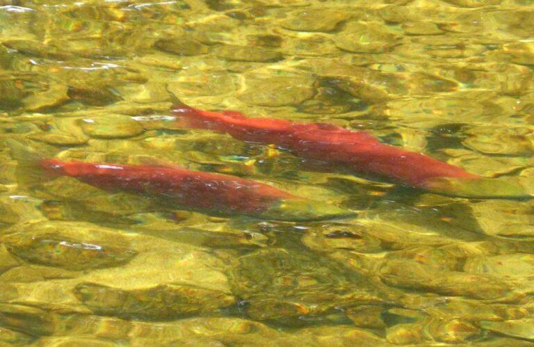
Photo: gailhampshire from Cradley, Malvern, U.K, CC BY 2.0

Fishing inside Cowlitz County: questions people bring
Where can a trailer back down to the water in Cowlitz County?
There are 14 launches, split as 11 WDFW and 3 other agencies.
Which lake gives Cowlitz County its most open water?
Lake Merwin, at 3,836 surface acres in the WDFW layer.
Which fish should a visitor to Cowlitz County plan on?
Rainbow trout lead the count of water pages within 50 miles, followed by largemouth bass, brown bullhead and coastal cutthroat trout.
Which Cowlitz County stores carry terminal tackle?
8 listings, such as Black Heron Fly Fishing.
How many guides list a Cowlitz County address?
Listings put 1 guide or charter here.
Which Washington town serves as seat of Cowlitz County?
It is Kelso.
What does WDFW charge to fish Cowlitz County?
For lakes and rivers the Freshwater license costs $39.95 with Washington residency, $115.85 without it.
Which counties are a short drive from Cowlitz County?
Try Lewis County, Clark County and Wahkiakum County.
Does the 2026-27 pamphlet list Special Rules for Cowlitz County?
The 2026-27 pamphlet prints 965 Special Rule entries touching this county, starting with Abernathy Creek; the table above shows the first ones.
Which WDFW records were set in Cowlitz County?
Warmouth, 0.53 lbs, from Silver Lake, Cowlitz County (May 27, 1996).
Where are the stocked lakes in Cowlitz County?
24 WDFW plants so far in 2026, 56,333 fish; the latest went into Lake Merwin on July 13, 2026.
Spend a morning on Cowlitz County water
River pages list runs and USGS flow.