Sinclair Inlet Fishing
Washington marine water in Kitsap County, inside Marine Area 10.
 Pick for troutPiscifun Carbon X ultralight spinning reel28% OFFSale $57.99
Photo, nearby stand in for Sinclair Inlet: Ken Lund, CC BY-SA 2.0
Sinclair Inlet: what saltwater anglers should know first
Sinclair Inlet lies inside WDFW Marine Area 10, beside Kitsap County. The closest Census place is Navy Yard City, under a mile away.
The WDFW and State Parks layers list 2 saltwater launches opening onto it. Shore anglers get 10 piers and shore sites. 2 named fishing areas are mapped within it. There are 59 marine rule rows in the 2026-27 pamphlet. It has 8 NOAA tide stations.
WDFW recreational marine area layer (WAC 220-311-010) on geodataservices.wdfw.wa.gov, USGS GNIS names, WDFW and State Parks launch layers, WDFW shore fishing layer; retrieved October 31, 2026.
What the rules and records name on Sinclair Inlet
Species named in the Sinclair Inlet marine rows or the WDFW records.
2026-27 WDFW pamphlet marine area rows and WDFW sport fish records; retrieved October 31, 2026.
 For the trout herePiscifun Carbon XT ultralight spinning reel25% OFFSale $59.99
Grounds anglers work on Sinclair Inlet
- Chico CreekShoreline Access Available
- Port Orchard/Point WhiteBoat Access Only
WDFW Major Fishing Areas layer on geodataservices.wdfw.wa.gov (names and access notes as published); retrieved October 31, 2026.
Launches near Sinclair Inlet
- Ross Point boat launch on Sinclair Inletn/a surface, Discover Pass, WDFW
- Illahee, pier and floats on Sinclair Inletboat ramp, Washington State Parks and Recreation Commission
Second-choice ramps close to Sinclair Inlet
- Misery Point boat launch on Dabob BayDabob Bay, 11 miles northwest
- North Bay boat launchn/a surface, Discover Pass, 13 miles southwest
- Sherwood Creek boat launch on Case InletCase Inlet, 14 miles southwest
- Pleasant Harbor1 ramp, concrete surface, Discover Pass, 15 miles northwest
- Triton Cove boat launchn/a surface, 1 hand launch, Discover Pass, 16 miles west
- Point Whitney boat launch on Dabob BayDabob Bay, 18 miles northwest
WDFW Water Access Sites and Shore Fishing Sites layers (geodataservices.wdfw.wa.gov) and the Washington State Parks boat launch layer, retrieved October 31, 2026. Parking at WDFW and State Parks launches needs a Discover Pass.
Fishing Sinclair Inlet without a boat
- Illahee City Pier on Sinclair Inletfishing pier, Marine Area 10
- Crystal Springs Public Fishing Pier on Sinclair Inletfishing pier, Marine Area 10
- Illahee State Park Pier on Sinclair Inletfishing pier, Marine Area 10
- Coal Dock (Lion's Community Park) on Sinclair Inletfishing pier, Marine Area 10
- Evergreen Park Boat Ramp on Sinclair Inletfishing pier, Marine Area 10
- Waterman Point Pier (Sinclair Inlet) on Sinclair Inletfishing pier, Marine Area 10
- Annapolis Dock (Retsil Pier) on Sinclair Inletfishing pier, Marine Area 10
- Bremerton Marina Public Dock on Sinclair Inletfishing pier, Marine Area 10
- Manchester Boat Dock on Sinclair Inletfishing pier, Marine Area 10
- Port Orchard Marina Dock on Sinclair Inletfishing pier, Marine Area 10
Bank and pier spots near Sinclair Inlet
- Silverdale Pierfishing pier, Marine Area 10, 7 miles
- Brownsville Dockfishing pier, Marine Area 10, 8 miles
- Blake Island State Park Pierfishing pier, Marine Area 10, 8 miles
- Seacrest Park Pier on Elliott Bayfishing pier, Marine Area 10, 13 miles
- Tramp Harbor Pier on Colvos Passagefishing pier, Marine Area 11, 14 miles
WDFW piers and shore fishing layers, retrieved October 31, 2026.
Bays you will pass on Sinclair Inlet
- Anderson Covecove Kitsap County
- Mud Baybay Kitsap County
- Ostrich Baybay Kitsap County
- Oyster Baybay Kitsap County
- Phinney Baybay Kitsap County
- Port Washington Narrowspassage/strait Kitsap County
USGS GNIS names inside the WDFW marine area polygon; retrieved October 31, 2026.
Water level gauges near Sinclair Inlet
NOAA CO-OPS water level, preliminary reading at retrieval (October 31, 2026); station page for live data.
- Bremerton, Sinclair Inlet, Port Orchardtide predictions, 2 miles
- Tracyton, Dyes Inlettide predictions, 5 miles
- Clam Bay, Rich Passagetide predictions, 5 miles
- Harper, Yukon Harbortide predictions, 6 miles
- Port Blakelytide predictions, 8 miles
- Brownsville, Port Orchardtide predictions, 8 miles
On Sinclair Inlet a large ebb against the wind can stand up steep chop; check the predictions first.
NOAA CO-OPS water level and tide prediction stations inside or beside the marine area; retrieved October 31, 2026.
Marina listings for Sinclair Inlet
- Bremerton Marinamarina 360/674-2381
- Port Orchard Marinamarina 360/674-2381
- Port Washington Marinamarina 360/479-3037
- Illahee State Parkmarina 360/902-8500
- Manchester Park & Boat Rampmarina 360/871-7563
Reef sites charted around Sinclair Inlet
- Blake Islandboat
NOAA Environmental Sensitivity Index atlas records (2003 to 2006); facility and reef details reflect the source year, not today. Retrieved october 31, 2026.
Salmon and bottomfish limits on Sinclair Inlet
| Species and location | Daily limit and size | Season |
|---|---|---|
| Trout | Catch-and-release | Year-round |
| Steelhead | Daily limit 2 hatchery steelhead. | Year-round |
| Sturgeon | Catch-and-release. | Year-round |
| Mackerel | No min. size. No daily limit. | Year-round |
| Herring, Anchovy, Sardine, Sand Lance, and Smelt | No min. size. Daily limit 10 lbs., all species combined. All smelt caught must be kept and count toward the daily limit except Closed to eulachon (Columbia River smelt). For smelt: Jig gear may be used 7 days a week. Dip | Year-round |
| Pacific Halibut | Check the WDFW website at https://wdfw.wa.gov/fishing/regulations/halibut or call (360) 902-2700 in March for information on Pacific halibut seasons and regulations. No min. size. Daily limit 1. Annual limit 6. Descendin | see the pamphlet |
| Other Food Fish | No min. size. Daily limit 2 of each species. See definition. | Year-round |
| All Other Fish | CLOSED to fishing for, retaining, or possessing. | CLOSED |
| Salmon (Entire Area (see exceptions for Shilshole Bay, West Elliott Bay, East Elliott Bay, Harbor Island (Duwa | No min. size. Daily limit 2. Release Chinook and chum. | June 1-July 22 |
| Salmon (Entire Area (see exceptions for Shilshole Bay, West Elliott Bay, East Elliott Bay, Harbor Island (Duwa | Chinook – min. size 22”. Other salmon species – no min. size. Daily limit 2 including no more than 1 Chinook. Release chum and wild Chinook. Additional Chinook openings may occur based on available quota. Check the WDFW | July 23-July 25 |
| Salmon (Entire Area (see exceptions for Shilshole Bay, West Elliott Bay, East Elliott Bay, Harbor Island (Duwa | No min. size. Daily limit 2. Release Chinook and chum. | July 26-Sept. 30 |
| Salmon (Entire Area (see exceptions for Shilshole Bay, West Elliott Bay, East Elliott Bay, Harbor Island (Duwa | No min. size. Daily limit 2. Release Chinook. | Oct. 1-Nov. 15 |
| Salmon (Entire Area (see exceptions for Shilshole Bay, West Elliott Bay, East Elliott Bay, Harbor Island (Duwa | CLOSED. | Nov. 16-Mar. 30 |
| Salmon (Entire Area (see exceptions for Shilshole Bay, West Elliott Bay, East Elliott Bay, Harbor Island (Duwa | Open Wed.-Sat. only. Closed Sun-Tues. Chinook – min. size 22”. Other salmon species – no min. size. Daily limit 2 including no more than 1 Chinook. Release chum and wild Chinook. | Mar. 31-Apr. 30 |
| Salmon (Shilshole Bay West Elliott Bay) | No min. size. Daily limit 2. Release Chinook and chum. | June 1-June 30 |
| Salmon (Shilshole Bay West Elliott Bay) | CLOSED. | July 1-Aug. 31 |
| Salmon (Shilshole Bay West Elliott Bay) | No min. size. Daily limit 2. Release Chinook and chum. | Sept. 1-Sept. 30 |
| Salmon (Shilshole Bay West Elliott Bay) | No min. size. Daily limit 2. Release Chinook. | Oct. 1-Nov. 15 |
| Salmon (Shilshole Bay West Elliott Bay) | CLOSED. | Nov. 16-Mar. 30 |
| Salmon (Shilshole Bay West Elliott Bay) | Open Wed.-Sat. only. Closed Sun-Tues. Chinook – min. size 22”. Other salmon species – no min. size. Daily limit 2 including no more than 1 Chinook. Release chum and wild Chinook. | Mar. 31-Apr. 30 |
| Salmon (East Elliott Bay) | No min. size. Daily limit 2. Release Chinook and chum. | June 1-June 30 |
| Salmon (East Elliott Bay) | CLOSED. | July 1-July 30 |
| Salmon (East Elliott Bay) | Chinook – min. size 22”. Other salmon species – no min. size. Daily limit 2. Release chum. | July 31-Aug. 3 (12:00 p.m.) |
| Salmon (East Elliott Bay) | CLOSED. | Aug. 3 (12:00 p.m.) – Aug. 31 |
The pamphlet prints 59 rows for Marine Area 10; 24 are shown here.
Anglers 16 and older fishing marine water carry a Saltwater license ($40.71 resident, $81.70 nonresident for 2026-27) or a Combination license, plus a catch record card for salmon, sturgeon, steelhead or halibut.
Limits and seasons as printed in the 2026-2027 Washington Sport Fishing Rules (WDFW pamphlet, in effect July 1, 2026 to June 30, 2027), PDF page 126 (pamphlet PDF; eRegulations marine area page), read October 31, 2026.
Harbors and port towns serving Sinclair Inlet
- BremertonKitsap County, 1 launch within 5 km
USGS GNIS populated places and harbors named by WDFW for the area; retrieved October 31, 2026.
How Sinclair Inlet lines up along the Sound and coast
| Water | Distance | Marine area | Launches | Piers and shore sites | Tide stations |
|---|---|---|---|---|---|
| Sinclair Inlet | Marine Area 10 | 2 | 10 | 8 | |
| Colvos Passage | 10 miles | Marine Area 11 | 0 | 2 | 7 |
| Hood Canal (Marine Area 12) | 12 miles | Marine Area 12 | 9 | 4 | 11 |
| Seattle-Bremerton (Marine Area 10) | 12 miles | Marine Area 10 | 3 | 22 | 16 |
| Elliott Bay | 14 miles | Marine Area 10 | 0 | 5 | 10 |
| Dabob Bay | 16 miles | Marine Area 12 | 4 | 1 | 7 |
WDFW marine areas and access layers, NOAA stations; retrieved October 31, 2026.
Just past Sinclair Inlet
Marine pages close to Sinclair Inlet
- Colvos Passage10 miles
- Hood Canal (Marine Area 12)12 miles
- Seattle-Bremerton (Marine Area 10)12 miles
- Elliott Bay14 miles
- Dabob Bay16 miles
Lakes, rivers and towns near Sinclair Inlet
- Kitsap Lake3 miles
- Long Lake (Kitsap County)5 miles
- Wildcat Lake7 miles
- Mission Lake8 miles
- Union River10 miles
- Tahuya River10 miles
- Rocky Creek13 miles
- Dewatto River15 miles
Grabbing bait and leader on the way to Sinclair Inlet
- Sportsman's Warehouse Silverdalesporting goods store, Silverdale, 8 miles
- Dick's Sporting Goods Silverdalesporting goods store, Silverdale, 8 miles
- Dick's Sporting Goods Seattlesporting goods store, Seattle, 19 miles
- Dick's Sporting Goods Tukwilasporting goods store, Tukwila, 20 miles
- Sportsman's Warehouse Federal Waysporting goods store, Federal Way, 24 miles
- Dick's Sporting Goods Tacomasporting goods store, Tacoma, 24 miles
Overnight bases close to Sinclair Inlet
- Navy Yard Cityunder a mile
- Port Orchard1 mile
- East Port Orchard2 miles
- Parkwood3 miles
Counties that touch Sinclair Inlet
- Kitsap Countyseat: Port Orchard
Rods and reels from Piscifun ahead of a trip to Sinclair Inlet


Piscifun and Amazon links are affiliate links; the site earns a commission on qualifying purchases.
A photo key to fish at Sinclair Inlet

Photo: Olympic National Park, Public domain

Photo: Oregon Department of Fish & Wildlife, Public domain
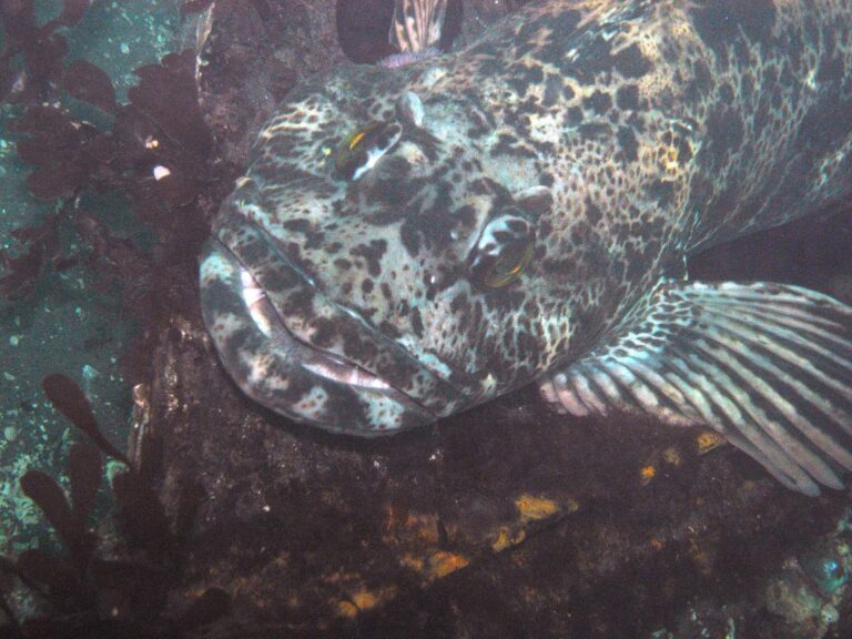
Photo: Patrick Briggs, CC BY 2.0
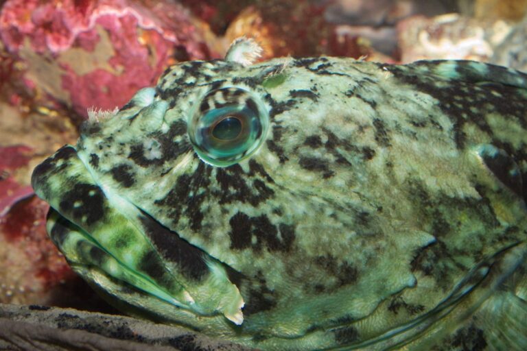
Photo: Brian Gratwicke, CC BY 2.0
Sinclair Inlet questions with short answers
Where does Sinclair Inlet sit in the WDFW system?
It is Marine Area 10 in the WDFW pamphlet.
Which salmon season covers Sinclair Inlet?
For Marine Area 10: No min. size. Daily limit 2. Release Chinook and chum.; season June 1-July 22. WDFW can amend it by emergency rule.
Can I keep lingcod from Sinclair Inlet?
Hook and line season. Min. size 26”. Max. size 36”. Daily limit 1., season May 1-June 15.
Does Sinclair Inlet have a public ramp in the WDFW or State Parks layers?
2 launches; Ross Point boat launch on Sinclair Inlet makes a good start.
Where can an angler on foot fish Sinclair Inlet?
10 piers and shore sites; start with Illahee City Pier on Sinclair Inlet.
Which WDFW license does an out-of-state angler buy for Sinclair Inlet?
Anglers 16 and older fishing marine water carry a Saltwater license ($40.71 resident, $81.70 nonresident for 2026-27) or a Combination license, plus a catch record card for salmon, sturgeon, steelhead or halibut.
Which NOAA station covers Sinclair Inlet?
NOAA predictions at Bremerton, Sinclair Inlet, Port Orchard cover it; the tide band links each station.
Which shop on our list is closest to Sinclair Inlet?
Try Sportsman's Warehouse Silverdale, about 8 miles away.
Which grounds are mapped in Sinclair Inlet?
WDFW charts 2 named fishing areas, such as Chico Creek and Port Orchard/Point White.
Time the tide and run out to Sinclair Inlet
Read the marine area rows, then pick a launch and a tide.