Rosario Strait Fishing
Washington marine water in Skagit and San Juan counties, inside Marine Area 7.
 Pick for troutPiscifun Carbon X ultralight spinning reel28% OFFSale $57.99
Photo: Jonathan Miske, CC BY-SA 2.0
Rosario Strait at a glance
WDFW counts Rosario Strait as part of Marine Area 7, off Skagit and San Juan counties. Plan on about 8 miles to reach Anacortes, the closest town.
Trailers go in at 1 saltwater launch near it. WDFW lists 1 pier or shore site too. WDFW charts 2 named fishing areas inside it. Seasons and limits run to 31 marine rule rows. Tide timing comes from 11 NOAA tide stations.
WDFW recreational marine area layer (WAC 220-311-010) on geodataservices.wdfw.wa.gov, USGS GNIS names, WDFW and State Parks launch layers, WDFW shore fishing layer; retrieved October 31, 2026.
Fish tied to Rosario Strait in our sources
Fish with a rule row or record on Rosario Strait.
2026-27 WDFW pamphlet marine area rows and WDFW sport fish records; retrieved October 31, 2026.
 For the trout herePiscifun Carbon XT ultralight spinning reel25% OFFSale $59.99
Named fishing grounds on Rosario Strait
- Lawerence PointBoat Access Only
- Rosario StraitBoat Access Only
WDFW Major Fishing Areas layer on geodataservices.wdfw.wa.gov (names and access notes as published); retrieved October 31, 2026.
Ramps boaters use for Rosario Strait
- James Island boat launch on Rosario Straitboat ramp, Washington State Parks and Recreation Commission
WDFW Water Access Sites and Shore Fishing Sites layers (geodataservices.wdfw.wa.gov) and the Washington State Parks boat launch layer, retrieved October 31, 2026. Parking at WDFW and State Parks launches needs a Discover Pass.
Piers that reach Rosario Strait
- Anacortes Municipal Pier on Rosario Straitfishing pier, Marine Area 7
Piers and shore sites by Rosario Strait
- Gooseberry Pt. Ferry Dock on Bellingham Bayfishing pier, Marine Area 7, 11 miles
- Bowman's Bay Pier on Deception Passfishing pier, Marine Area 6, 11 miles
- Cornet Bay Docks on Deception Passfishing pier, Marine Area 8-1, 13 miles
- Friday Harbor Marina Docksfishing pier, Marine Area 7, 13 miles
- Boulevard Park Pier (Bellingham) on Bellingham Bayfishing pier, Marine Area 7, 15 miles
WDFW piers and shore fishing layers, retrieved October 31, 2026.
Harbors and bays inside Rosario Strait
- Bellingham Channelpassage/strait Skagit County
- Deepwater Baybay Skagit County
- Eagle Harborharbor Skagit County
- Peavine Passpassage/strait San Juan County
- Secret Harborharbor Skagit County
- Strawberry Baybay Skagit County
- Thatcher Baybay San Juan County
USGS GNIS names inside the WDFW marine area polygon; retrieved October 31, 2026.
Tide stations for Rosario Strait
NOAA CO-OPS water level, preliminary reading at retrieval (October 31, 2026); station page for live data.
- Strawberry Bay, Cypress Islandtide predictions, under a mile
- Tide Point, Cypress Islandtide predictions, 1 mile
- Armitage Island, Thatcher Passtide predictions, 4 miles
- Ship Harbor, Fidalgo Islandtide predictions, 5 miles
- Anacortes, Guemes Channeltide predictions, 7 miles
- Upright Head, Lopez Islandtide predictions, 7 miles
Big tidal exchanges move fish and boats on Rosario Strait; slack water is the easy window for jigging bottomfish.
NOAA CO-OPS water level and tide prediction stations inside or beside the marine area; retrieved October 31, 2026.
Marinas charted near Rosario Strait
- Olga Community Floatmarina 360/902-8500
- James Islandmarina 360/902-8500
- Lieber Haven Resortmarina 360/376-2472
- Spencer Spit State Parkmarina 360/902-8500
- Doe Islandmarina 360/902-8500
NOAA Environmental Sensitivity Index atlas records (2003 to 2006); facility and reef details reflect the source year, not today. Retrieved october 31, 2026.
Keeping salmon and lingcod from Rosario Strait
| Species and location | Daily limit and size | Season |
|---|---|---|
| Trout | Catch-and-release. | Year-round |
| Steelhead | Daily limit 2 hatchery steelhead. | Year-round |
| Sturgeon | Catch-and-release. | Year-round |
| Mackerel | No min. size. No daily limit. | Year-round |
| Herring, Anchovy, Sardine, Sand Lance, and Smelt | No min. size. Daily limit 10 lbs., all species combined. All smelt caught must be kept and count toward the daily limit except Closed to eulachon (Columbia River smelt). Herring – Closed year-round north of a line from S | Year-round |
| Pacific Halibut | Check the WDFW website at https://wdfw.wa.gov/fishing/regulations/halibut or call (360) 902-2700 in March for information on Pacific halibut seasons and regulations. No min. size. Daily limit 1. Annual limit 6. Descendin | see the pamphlet |
| Other Food Fish | No min. size. Daily limit 2 of each species. See definition. | Year-round |
| All Other Fish | CLOSED to fishing for, retaining, or possessing. | CLOSED |
| Salmon (Entire Area (see exceptions for Lummi Indian Reservation and Lummi Bay, Samish Bay, Yellow and Low Isl | Chinook – min. size 22”. Other salmon species – no min. size. Daily limit 2 including no more than 1 Chinook. Release chum, sockeye, wild coho, and wild Chinook. Additional Chinook openings may occur based on available q | July 16-July 18 |
| Salmon (Entire Area (see exceptions for Lummi Indian Reservation and Lummi Bay, Samish Bay, Yellow and Low Isl | CLOSED. | July 19-July 31 |
| Salmon (Entire Area (see exceptions for Lummi Indian Reservation and Lummi Bay, Samish Bay, Yellow and Low Isl | No min. size. Daily limit 2. Release Chinook, chum, sockeye, and wild coho. | Aug. 1-Aug. 31 |
| Salmon (Entire Area (see exceptions for Lummi Indian Reservation and Lummi Bay, Samish Bay, Yellow and Low Isl | No min. size. Daily limit 2. Release Chinook, sockeye, and chum. | Sept. 1-Sept. 30 |
| Salmon (Lummi Indian Reservation and Lummi Bay Area) | CLOSED. | Year-round |
| Salmon (Samish Bay) | CLOSED. | Year-round |
| Salmon (Yellow and Low Islands Preserve) | CLOSED. | Year-round |
| Salmon (Southern Rosario Strait/Eastern Strait of Juan de Fuca) | CLOSED. | Year-round |
| Salmon (Bellingham Bay (see exception for Hale Pass below)) | CLOSED. | July 1-July 31 |
| Salmon (Bellingham Bay (see exception for Hale Pass below)) | Chinook – min. size 22”. Other salmon species – no min. size. Daily limit 3. | Aug. 1-Sept. 30 |
| Salmon (Bellingham Bay (see exception for Hale Pass below)) | CLOSED. | Oct. 1-June 30 |
| Salmon (Hale Pass) | CLOSED. | July 1-Aug. 31 |
| Salmon (Hale Pass) | Chinook – min. size 22”. Other salmon species – no min. size. Daily limit 3. | Sept.1-Sept. 30 |
| Salmon (Hale Pass) | CLOSED. | Oct. 1-June 30 |
| Bottomfish | Year-round season. Daily limit is a total of 15 bottomfish (See definition) subject to individual limits and seasons shown below. Fishing for bottomfish prohibited in waters deeper than 120’. Descending device required o | see the pamphlet |
| Lingcod | Hook and line season. Min. size 26”. Max. size 36”. Daily limit 1. | May 1-June 15 |
Marine Area 7 carries 31 rows; the rest are in the pamphlet.
Anglers 16 and older fishing marine water carry a Saltwater license ($40.71 resident, $81.70 nonresident for 2026-27) or a Combination license, plus a catch record card for salmon, sturgeon, steelhead or halibut.
Limits and seasons as printed in the 2026-2027 Washington Sport Fishing Rules (WDFW pamphlet, in effect July 1, 2026 to June 30, 2027), PDF page 121 (pamphlet PDF; eRegulations marine area page), read October 31, 2026.
Rosario Strait beside other Washington marine water
| Water | Distance | Marine area | Launches | Piers and shore sites | Tide stations |
|---|---|---|---|---|---|
| Rosario Strait | Marine Area 7 | 1 | 1 | 11 | |
| San Juan Islands (Marine Area 7) | 7 miles | Marine Area 7 | 8 | 6 | 28 |
| Bellingham Bay | 12 miles | Marine Area 7 | 0 | 3 | 4 |
| Deception Pass | 12 miles | Marine Area 8-1 | 3 | 3 | 15 |
| Skagit Bay | 21 miles | Marine Area 8-1 | 3 | 1 | 9 |
| Deception Pass, Hope Island, and Skagit Bay (Marine Area 8-1) | 24 miles | Marine Area 8-1 | 5 | 5 | 10 |
WDFW marine areas and access layers, NOAA stations; retrieved October 31, 2026.
Next to Rosario Strait
Next marine pages from Rosario Strait
- San Juan Islands (Marine Area 7)7 miles
- Bellingham Bay12 miles
- Deception Pass12 miles
- Skagit Bay21 miles
- Deception Pass, Hope Island, and Skagit Bay (Marine Area 8-1)24 miles
Inland options close to Rosario Strait
- Mountain Lake7 miles
- Hummel Lake8 miles
- Cascade Lake8 miles
- Heart Lake (Skagit County)8 miles
- Samish River17 miles
- North Fork Skagit River19 miles
- Skagit River21 miles
- South Fork Skagit River23 miles
Tackle counters within a quick drive of Rosario Strait
- Dick's Sporting Goods Bellinghamsporting goods store, Bellingham, 19 miles
- Sportsman's Warehouse Bellinghamsporting goods store, Bellingham, 20 miles
- FHR – Friday Harbor Airportmarina, Friday Harbor
- Harbor Rental and Saw Shopmarina, Friday Harbor
- San Juan Outfittersmarina, Friday Harbor
- Shell Marinamarina, Friday Harbor
Washington towns with beds close by Rosario Strait
- Anacortes8 miles
- Friday Harbor13 miles
- Whidbey Island Station16 miles
- Marietta-Alderwood17 miles
The counties around Rosario Strait
- Skagit Countyseat: Mount Vernon
- San Juan Countyseat: Friday Harbor
A Piscifun spinning setup worth packing for Rosario Strait


Piscifun and Amazon links are affiliate links; the site earns a commission on qualifying purchases.
How to tell one Rosario Strait fish from another, by photo
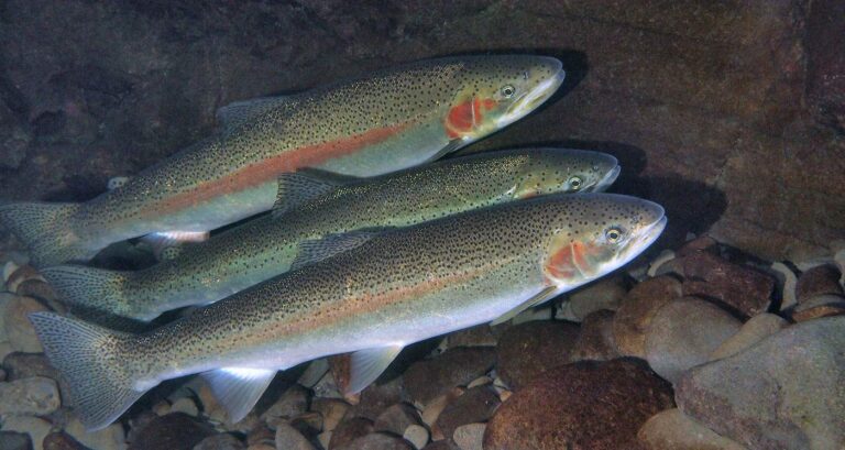
Photo: Oregon State University, CC BY-SA 2.0

Photo: USFWS Fish and Aquatic Conservation, Public domain

Photo: Ed Bierman, CC BY 2.0
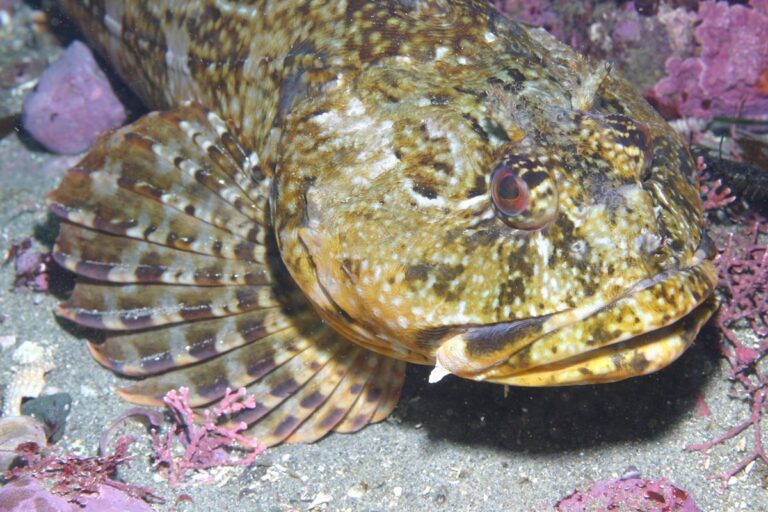
Photo: Steve Lonhart (SIMoN / MBNMS), Public domain

Quick replies about fishing Rosario Strait
Which rule area covers Rosario Strait?
It falls under Marine Area 7.
How many salmon may I keep from Rosario Strait?
Chinook – min. size 22”. Other salmon species – no min. size. Daily limit 2 including no more than 1 Chinook. Release chum, sockeye, wild coho, and wild Chinook (July 16-July 18) under Marine Area 7; emergency rules override.
When is lingcod season on Rosario Strait?
Pamphlet lingcod row: Hook and line season. Min. size 26”. Max. size 36”. Daily limit 1. (May 1-June 15).
Where do salmon boats put in for Rosario Strait?
1 launch appear in the access layers, including James Island boat launch on Rosario Strait.
Can I fish Rosario Strait from shore?
1 pier or shore site on the WDFW layer, Anacortes Municipal Pier on Rosario Strait among them.
Does Rosario Strait take a Saltwater or Combination license?
Anglers 16 and older fishing marine water carry a Saltwater license ($40.71 resident, $81.70 nonresident for 2026-27) or a Combination license, plus a catch record card for salmon, sturgeon, steelhead or halibut.
How big are the tides on Rosario Strait?
Strawberry Bay, Cypress Island is the closest prediction station in our list.
Which store do Rosario Strait regulars use for herring and leader?
Dick's Sporting Goods Bellingham, about 19 miles away leads our list here.
Where do anglers fish on Rosario Strait?
The WDFW layer marks 2 named fishing areas, Lawerence Point and Rosario Strait among them.
Book a morning on Rosario Strait
Marine seasons, limits and fees live on one page.