San Juan Islands Fishing, Marine Area 7
WDFW Marine Area 7 on the Washington coast and Salish Sea, touching San Juan, Whatcom and Skagit counties.
 Pick for lingcodPiscifun AlinoX 400 baitcaster with bait clicker25% OFFSale $149.99
Photo: Bureau of Land Management, CC BY 2.0
San Juan Islands: what saltwater anglers should know first
San Juan Islands is WDFW recreational Marine Area 7, defined in WAC 220-311-010 and touching San Juan, Whatcom and Skagit counties. The closest Census place is Anacortes, roughly 10 miles away.
The WDFW and State Parks layers list 8 saltwater launches opening onto it. Shore anglers get 6 piers and shore sites. 4 named fishing areas are mapped within it. There are 31 marine rule rows in the 2026-27 pamphlet. It has 28 NOAA tide stations.
On the boundary: WDFW Marine Area 7 (San Juan Islands).
WDFW recreational marine area layer (WAC 220-311-010) on geodataservices.wdfw.wa.gov, USGS GNIS names, WDFW and State Parks launch layers, WDFW shore fishing layer; retrieved October 31, 2026.
How WAC draws San Juan Islands
- Defined(8)(b): … the Burlington Northern Railroad Bridge at the north end of Swinomish Slough …
- Defined(6): … the Lawson Reef lighted buoys (RB1 QK Fl Bell) – Northwest Island – the Initiative 77 marker on Fidalgo Island.
- Defined(6): … Smith Island [light] – the most northeasterly of the Lawson Reef lighted buoys …
- Defined(6): … Rosario Strait Traffic Lane Entrance Lighted Buoy R – Smith Island [light] …
- InternationalNone. USA – Canada border
- Defined(6): … the line from Trial Island (near Victoria, B.C.) – Rosario Strait Traffic Lane Entrance Lighted Buoy R …
Buoys and lights around San Juan Islands
- Initiative 77 markerMarker White stripe painted on cliff
- Lawson Reef LightLight RG Fl (2+1) R 6s Bell
- Light RLight Fl Y 4s
- Smith I. LightLight Fl 10s
- Railroad BridgeBridge
WAC 220-311-010 boundary text as published in the WDFW marine area layer; NOAA light list positions; retrieved October 31, 2026.
What the rules and records name on San Juan Islands
Species named in the San Juan Islands marine rows or the WDFW records.
2026-27 WDFW pamphlet marine area rows and WDFW sport fish records; retrieved October 31, 2026.
 For the lingcod herePiscifun Saltflow offshore rod25% OFFSale $299.99
Grounds anglers work on San Juan Islands
- Eagle Point/Salmon BankBoat Access Only
- Hein/Middle BankBoat Access Only
- Lawerence PointBoat Access Only
- Rosario StraitBoat Access Only
WDFW Major Fishing Areas layer on geodataservices.wdfw.wa.gov (names and access notes as published); retrieved October 31, 2026.
Launches near San Juan Islands
- Stuart Island, Prevost HarborDiscover Pass, Washington State Parks and Recreation Commission
- Stuart Island, Reid HarborDiscover Pass, Washington State Parks and Recreation Commission
- Stuart Island, Reid Harbor moorage floatDiscover Pass, Washington State Parks and Recreation Commission
- Stuart Island, Reid Harbor pump out floatDiscover Pass, Washington State Parks and Recreation Commission
- James Island boat launch on Rosario Straitboat ramp, Washington State Parks and Recreation Commission
- Jones Island boat launchboat ramp, Washington State Parks and Recreation Commission
- Matia Island boat launchboat ramp, Washington State Parks and Recreation Commission
- Sucia Island, Fossil Bay boat launchboat ramp, Washington State Parks and Recreation Commission
WDFW Water Access Sites and Shore Fishing Sites layers (geodataservices.wdfw.wa.gov) and the Washington State Parks boat launch layer, retrieved October 31, 2026. Parking at WDFW and State Parks launches needs a Discover Pass.
Fishing San Juan Islands without a boat
- Drayton Harbor Park Pier (Port of Bellingham)fishing pier, Marine Area 7
- Gooseberry Pt. Ferry Dock on Bellingham Bayfishing pier, Marine Area 7
- Boulevard Park Pier (Bellingham) on Bellingham Bayfishing pier, Marine Area 7
- Bellingham Cruise Terminal on Bellingham Bayfishing pier, Marine Area 7
- Anacortes Municipal Pier on Rosario Straitfishing pier, Marine Area 7
- Friday Harbor Marina Docksfishing pier, Marine Area 7
Bank and pier spots near San Juan Islands
- Bowman's Bay Pier on Deception Passfishing pier, Marine Area 6, 15 miles
- Cornet Bay Docks on Deception Passfishing pier, Marine Area 8-1, 16 miles
- La Conner Marina Docks on Skagit Bayfishing pier, Marine Area 8-1, 18 miles
WDFW piers and shore fishing layers, retrieved October 31, 2026.
Bays you will pass on San Juan Islands
- Active Covecove San Juan County
- Aleck Baybay San Juan County
- Alice Bightother named water Skagit County
- Allan Passpassage/strait Skagit County
- Andrews Baybay San Juan County
- Argyle Lagoonlagoon San Juan County
- Barlow Baybay San Juan County
- Bellingham Channelpassage/strait Skagit County
- Birch Baybay Whatcom County
- Blind Baybay San Juan County
- Boat Channelpassage/strait San Juan County
- Boat Harborharbor Skagit County
- Boundary Baybay Whatcom County
- Boundary Passpassage/strait San Juan County
- Brigantine Baybay San Juan County
- Buck Baybay San Juan County
- Buoy Baybay San Juan County
- Burrows Baybay Skagit County
- Burrows Passpassage/strait Skagit County
- Cap Sante Waterwayother named water Skagit County
- Careen Creekother named water San Juan County
- Cascade Baybay San Juan County
- Cayou Channelpassage/strait San Juan County
- Chuckanut Baybay Whatcom County
- Cooks Covecove Skagit County
- Coon Hollowother named water San Juan County
- Cowlitz Baybay San Juan County
- Davis Baybay San Juan County
- Davis Baybay San Juan County
- Deadman Baybay San Juan County
Only 30 of 169 named features fit.
USGS GNIS names inside the WDFW marine area polygon; retrieved October 31, 2026.
Water level gauges near San Juan Islands
NOAA CO-OPS water level, preliminary reading at retrieval (October 31, 2026); station page for live data.
- Swinomish Channel Ent., Padilla Baytide predictions, 14 miles
- Burrows Bay (Allan Island)tide predictions, 13 miles
- Ship Harbor, Fidalgo Islandtide predictions, 9 miles
- Anacortes, Guemes Channeltide predictions, 8 miles
- Strawberry Bay, Cypress Islandtide predictions, 6 miles
- Tide Point, Cypress Islandtide predictions, 6 miles
On San Juan Islands a large ebb against the wind can stand up steep chop; check the predictions first.
NOAA CO-OPS water level and tide prediction stations inside or beside the marine area; retrieved October 31, 2026.
Marina listings for San Juan Islands
- West Beach Resortmarina 360/376-2240
- West Sound Marinamarina 360/376-2314
- Skyline Marinamarina 360/293-5134
- Point Roberts Marina And Resortmarina 360/945-2255
- Olga Community Floatmarina 360/902-8500
- Blaine Harbormarina 360/676-2500
- James Islandmarina 360/902-8500
- Lieber Haven Resortmarina 360/376-2472
- Little Portion Storemarina 360/468-2288
- Matia Island State Parkmarina 360/902-8500
- Stuart Island – Prevost Harbormarina 360/902-8500
- Stuart Island – Reid Harbormarina 360/902-8500
- Albert Jensen & Sonsmarina 360/378-4343
- Anacortes Marinamarina 360/293-4543
- Blind Island Marine State Parkmarina 360/902-8500
- Cap Sante Boat Havenmarina 360/293-3134
NOAA Environmental Sensitivity Index atlas records (2003 to 2006); facility and reef details reflect the source year, not today. Retrieved october 31, 2026.
Salmon and bottomfish limits on San Juan Islands
| Species and location | Daily limit and size | Season |
|---|---|---|
| Trout | Catch-and-release. | Year-round |
| Steelhead | Daily limit 2 hatchery steelhead. | Year-round |
| Sturgeon | Catch-and-release. | Year-round |
| Mackerel | No min. size. No daily limit. | Year-round |
| Herring, Anchovy, Sardine, Sand Lance, and Smelt | No min. size. Daily limit 10 lbs., all species combined. All smelt caught must be kept and count toward the daily limit except Closed to eulachon (Columbia River smelt). Herring – Closed year-round north of a line from S | Year-round |
| Pacific Halibut | Check the WDFW website at https://wdfw.wa.gov/fishing/regulations/halibut or call (360) 902-2700 in March for information on Pacific halibut seasons and regulations. No min. size. Daily limit 1. Annual limit 6. Descendin | see the pamphlet |
| Other Food Fish | No min. size. Daily limit 2 of each species. See definition. | Year-round |
| All Other Fish | CLOSED to fishing for, retaining, or possessing. | CLOSED |
| Salmon (Entire Area (see exceptions for Lummi Indian Reservation and Lummi Bay, Samish Bay, Yellow and Low Isl | Chinook – min. size 22”. Other salmon species – no min. size. Daily limit 2 including no more than 1 Chinook. Release chum, sockeye, wild coho, and wild Chinook. Additional Chinook openings may occur based on available q | July 16-July 18 |
| Salmon (Entire Area (see exceptions for Lummi Indian Reservation and Lummi Bay, Samish Bay, Yellow and Low Isl | CLOSED. | July 19-July 31 |
| Salmon (Entire Area (see exceptions for Lummi Indian Reservation and Lummi Bay, Samish Bay, Yellow and Low Isl | No min. size. Daily limit 2. Release Chinook, chum, sockeye, and wild coho. | Aug. 1-Aug. 31 |
| Salmon (Entire Area (see exceptions for Lummi Indian Reservation and Lummi Bay, Samish Bay, Yellow and Low Isl | No min. size. Daily limit 2. Release Chinook, sockeye, and chum. | Sept. 1-Sept. 30 |
| Salmon (Lummi Indian Reservation and Lummi Bay Area) | CLOSED. | Year-round |
| Salmon (Samish Bay) | CLOSED. | Year-round |
| Salmon (Yellow and Low Islands Preserve) | CLOSED. | Year-round |
| Salmon (Southern Rosario Strait/Eastern Strait of Juan de Fuca) | CLOSED. | Year-round |
| Salmon (Bellingham Bay (see exception for Hale Pass below)) | CLOSED. | July 1-July 31 |
| Salmon (Bellingham Bay (see exception for Hale Pass below)) | Chinook – min. size 22”. Other salmon species – no min. size. Daily limit 3. | Aug. 1-Sept. 30 |
| Salmon (Bellingham Bay (see exception for Hale Pass below)) | CLOSED. | Oct. 1-June 30 |
| Salmon (Hale Pass) | CLOSED. | July 1-Aug. 31 |
| Salmon (Hale Pass) | Chinook – min. size 22”. Other salmon species – no min. size. Daily limit 3. | Sept.1-Sept. 30 |
| Salmon (Hale Pass) | CLOSED. | Oct. 1-June 30 |
| Bottomfish | Year-round season. Daily limit is a total of 15 bottomfish (See definition) subject to individual limits and seasons shown below. Fishing for bottomfish prohibited in waters deeper than 120’. Descending device required o | see the pamphlet |
| Lingcod | Hook and line season. Min. size 26”. Max. size 36”. Daily limit 1. | May 1-June 15 |
The pamphlet prints 31 rows for Marine Area 7; 24 are shown here.
Anglers 16 and older fishing marine water carry a Saltwater license ($40.71 resident, $81.70 nonresident for 2026-27) or a Combination license, plus a catch record card for salmon, sturgeon, steelhead or halibut.
Limits and seasons as printed in the 2026-2027 Washington Sport Fishing Rules (WDFW pamphlet, in effect July 1, 2026 to June 30, 2027), PDF page 121 (pamphlet PDF; eRegulations marine area page), read October 31, 2026.
San Juan Islands in the WDFW sport fish records
| Species | Weight | Angler | Water as printed | Date |
|---|---|---|---|---|
| Lingcod | 61.00 lbs | Tom Nelson | San Juan Islands, San Juan County | July 30, 1986 |
| Sand sole | 2.59 lbs | Shannon Reiss | San Juan Islands, San Juan County | March 31, 2019 |
WDFW sport fish records (freshwater and saltwater record lists, kept by the Washington Department of Fish and Wildlife (WDFW)) as listed October 31, 2026. All Washington records.
How San Juan Islands lines up along the Sound and coast
| Water | Distance | Marine area | Launches | Piers and shore sites | Tide stations |
|---|---|---|---|---|---|
| San Juan Islands | Marine Area 7 | 8 | 6 | 28 | |
| Bellingham Bay | 5 miles | Marine Area 7 | 0 | 3 | 4 |
| Rosario Strait | 7 miles | Marine Area 7 | 1 | 1 | 11 |
| Deception Pass | 16 miles | Marine Area 8-1 | 3 | 3 | 15 |
| Skagit Bay | 23 miles | Marine Area 8-1 | 3 | 1 | 9 |
| Deception Pass, Hope Island, and Skagit Bay (Marine Area 8-1) | 28 miles | Marine Area 8-1 | 5 | 5 | 10 |
WDFW marine areas and access layers, NOAA stations; retrieved October 31, 2026.
Just past San Juan Islands
Marine pages close to San Juan Islands
- Bellingham Bay5 miles
- Rosario Strait7 miles
- Deception Pass16 miles
- Skagit Bay23 miles
- Deception Pass, Hope Island, and Skagit Bay (Marine Area 8-1)28 miles
Lakes, rivers and towns near San Juan Islands
- Mountain Lake9 miles
- Pine Lake (Whatcom County)9 miles
- Lake Padden9 miles
- Cascade Lake10 miles
- Samish River14 miles
- Skagit River20 miles
- North Fork Skagit River21 miles
- South Fork Nooksack River21 miles
Grabbing bait and leader on the way to San Juan Islands
- Dick's Sporting Goods Bellinghamsporting goods store, Bellingham, 12 miles
- Sportsman's Warehouse Bellinghamsporting goods store, Bellingham, 13 miles
- FHR – Friday Harbor Airportmarina, Friday Harbor
- Harbor Rental and Saw Shopmarina, Friday Harbor
- San Juan Outfittersmarina, Friday Harbor
- Shell Marinamarina, Friday Harbor
Overnight bases close to San Juan Islands
- Anacortes10 miles
- Bellingham11 miles
- Marietta-Alderwood11 miles
- Geneva13 miles
Counties that touch San Juan Islands
- San Juan Countyseat: Friday Harbor
- Whatcom Countyseat: Bellingham
- Skagit Countyseat: Mount Vernon
Rods and reels from Piscifun ahead of a trip to San Juan Islands


Piscifun and Amazon links are affiliate links; the site earns a commission on qualifying purchases.
A photo key to fish at San Juan Islands
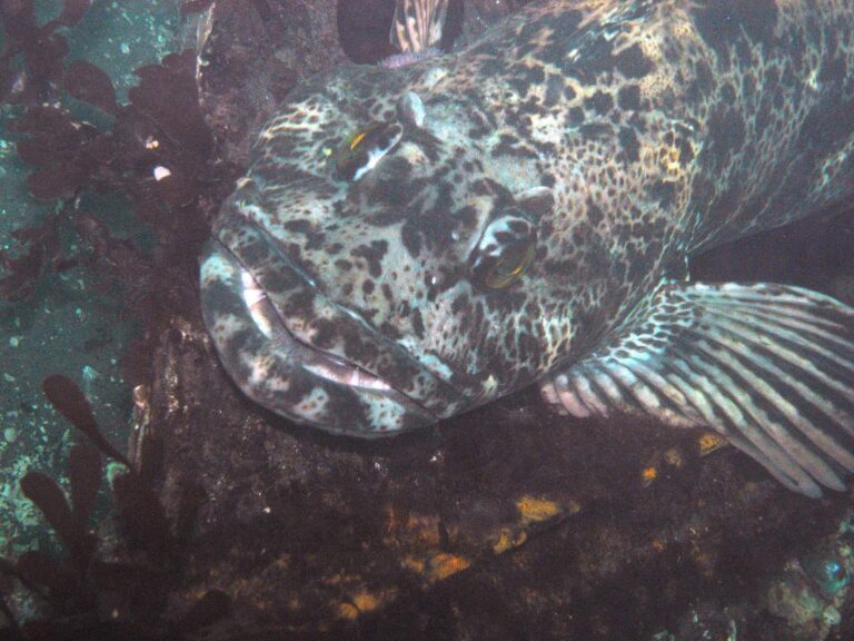
Photo: Patrick Briggs, CC BY 2.0

Photo: Olympic National Park, Public domain

Photo: Unknown authorUnknown author, Public domain

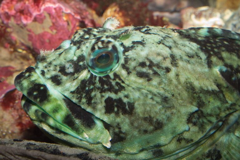
Photo: Brian Gratwicke, CC BY 2.0
San Juan Islands questions with short answers
Where does San Juan Islands sit in the WDFW system?
It is Marine Area 7 in the WDFW pamphlet.
Which salmon season covers San Juan Islands?
For Marine Area 7: Chinook – min. size 22”. Other salmon species – no min. size. Daily limit 2 including no more than 1 Chinook. Release chum, sockeye, wild coho, and wild Chinook; season July 16-July 18. WDFW can amend it by emergency rule.
Can I keep lingcod from San Juan Islands?
Hook and line season. Min. size 26”. Max. size 36”. Daily limit 1., season May 1-June 15.
Does San Juan Islands have a public ramp in the WDFW or State Parks layers?
8 launches; Stuart Island, Prevost Harbor makes a good start.
Where can an angler on foot fish San Juan Islands?
6 piers and shore sites; start with Drayton Harbor Park Pier (Port of Bellingham).
Which WDFW license does an out-of-state angler buy for San Juan Islands?
Anglers 16 and older fishing marine water carry a Saltwater license ($40.71 resident, $81.70 nonresident for 2026-27) or a Combination license, plus a catch record card for salmon, sturgeon, steelhead or halibut.
Which NOAA station covers San Juan Islands?
NOAA predictions at Swinomish Channel Ent., Padilla Bay cover it; the tide band links each station.
Which shop on our list is closest to San Juan Islands?
Try Dick's Sporting Goods Bellingham, about 12 miles away.
Which grounds are mapped in San Juan Islands?
WDFW charts 4 named fishing areas, such as Eagle Point/Salmon Bank, Hein/Middle Bank and Lawerence Point.
What record fish came out of San Juan Islands?
Lingcod, 61.00 lbs, by Tom Nelson (July 30, 1986).
Time the tide and run out to San Juan Islands
Read the marine area rows, then pick a launch and a tide.