Fishing in Uintah County, Utah
County seat: Vernal. Census 2020 residents: 35,620.
- 12lake pages
- 14launches
- 2river pages
 Pick for largemouth bassPiscifun Chaos Pro CNC baitcasting reel25% OFFSale $97.99
Photo of Flaming Gorge Reservoir: Tony Webster, CC BY-SA 4.0
An overview of the water in Uintah County
With Vernal as its seat, Uintah County recorded 35,620 residents in the 2020 Census. Inside the county boundary the Gazetteer counts 4,483 square miles of land and 21.6 square miles of water. Of the 12 Utah lakes and reservoirs in the county with pages, Pelican Lake spreads widest.
Boaters have 14 launches in the county; shore anglers have 13 shore or pier points. For a river day, look at Green River in northeastern Utah and White River. Community fisheries in the county include Old Fort Ponds. Across 26 waters, DWR recorded 67,641 fish stocked here in 2026 (56 rows).
U.S. Census Bureau, 2020 Census counts (TIGERweb) and the 2023 Gazetteer, read November 11, 2026. UGRC Boat Ramps layer (ArcGIS service) and the DWR Fish Utah access list, read November 11, 2026.
Where the Utah launch points fall in Uintah County
UGRC Boat Ramps layer (ArcGIS service) and the DWR Fish Utah access list, read November 11, 2026. Lake pins are the DWR map point for each water.
Still water inside Uintah County
| Lake | Size | Launches | Status | DWR lists |
|---|---|---|---|---|
| Pelican Lake | 1560 | 1 | natural lake | bluegill, largemouth bass, wiper, muskie Tiger, sunfish Bluegill, bass Largemouth |
| Steinaker Reservoir | 829 | 2 | reservoir | bluegill, largemouth bass, rainbow trout, cutbow Ctbl*Rtwv |
| Red Fleet Reservoir | 580 | 1 | reservoir | black crappie, bluegill, largemouth bass, mountain whitefish, rainbow trout, tiger trout, walleye, wiper, yellow perch, |
| Matt Warner Reservoir | 333 | 3 | reservoir | rainbow trout, grass Carp Sterile |
| East Park Reservoir | about 178 acres of mapped outline | 0 | reservoir | brook trout, rainbow trout, tiger trout |
| Crouse Reservoir | 85 acres at full pool | 2 | reservoir | rainbow trout, grass Carp Sterile, bonneville cutthroat trout |
| Calder Reservoir | 80 | 1 | reservoir | colorado River cutthroat trout, rainbow trout, bonneville cutthroat trout, grass Carp Sterile |
| Bullock Reservoir | 98 | 0 | reservoir | tiger muskellunge, muskie Tiger, grass Carp Sterile, bass Largemouth, rainbow trout, sunfish Bluegill, sucker |
| Brough Reservoir | 120 | 0 | reservoir | common carp, largemouth bass, rainbow trout, wiper, bass Largemouth, channel catfish |
| Cottonwood Reservoir | 210 | 0 | reservoir | tiger muskellunge, muskie Tiger, rainbow trout, sunfish Bluegill, sucker |
| Little Montes Reservoir | 40 | 0 | reservoir | bluegill, largemouth bass, rainbow trout, grass Carp Sterile, brook trout |
| Old Fort Ponds | < 2 acres | 0 | community fishery | bluegill, rainbow trout, tiger trout, channel catfish, grass Carp Sterile, muskie Tiger |
Size as the DWR Fish Utah page for this water prints it (DWR), read November 11, 2026. Waters with no DWR acreage print their mapped outline instead. Utah DWR Fish Utah planner (dwrapps.utah.gov), read November 11, 2026.
 For the largemouth bass herePiscifun AlinoX 300 low profile baitcaster34% OFFSale $104.99
Which fish Fish Utah keeps naming near Uintah County
Summing Fish Utah lists for lakes within 40 miles of Vernal, rainbow trout comes out on top.
DWR Fish Utah species lists (likely or possible), counted per lake page within 40 miles; DWR’s ratings, not a catch survey. Utah DWR Fish Utah planner (dwrapps.utah.gov), read November 11, 2026.
Trailhead Utah lake areas inside Uintah County
- Uinta Mountains, South Slope Eastbrook trout, colorado River cutthroat trout, grayling Arctic, bonneville cutthroat trout, rainbow trout, tiger trout, mu, 40 recent stocking rows
Utah DWR Fish Utah planner (dwrapps.utah.gov), read November 11, 2026.
Utah lakes of Uintah County with only a name and an outline
Past the paged lakes, Uintah County holds 20 named waters on UGRC and DWR maps.
| Water | Size | Listed by |
|---|---|---|
| Oaks Park Reservoir | about 339 acres of mapped outline | UGRC lakes layer |
| Stauffer Chemical Tailings Pond North | about 236 acres of mapped outline | UGRC lakes layer |
| Paradise Park Reservoir | about 149 acres of mapped outline | UGRC lakes layer |
| Montes Creek Reservoir | about 99 acres of mapped outline | UGRC lakes layer |
| Pariette East Dike Reservoir | about 70 acres of mapped outline | UGRC lakes layer |
| Towave Reservoir | about 58 acres of mapped outline | UGRC lakes layer |
| Long Park Reservoir | about 43 acres of mapped outline | UGRC lakes layer |
| Stewart Lake | about 36 acres of mapped outline | UGRC lakes layer |
| Gull Lake | about 33 acres of mapped outline | UGRC lakes layer |
| Ashley Twin Lakes | about 31 acres of mapped outline | UGRC lakes layer |
| Whiterocks Lake | about 29 acres of mapped outline | UGRC lakes layer |
| Julius Park Reservoir | about 24 acres of mapped outline | UGRC lakes layer |
| Goose Lakes | about 21 acres of mapped outline | UGRC lakes layer |
| Fish Lake | about 17 acres of mapped outline | UGRC lakes layer |
| Wooley Lakes | about 16 acres of mapped outline | UGRC lakes layer |
| Teds Lake | about 14 acres of mapped outline | UGRC lakes layer |
| Montes Creek Reservoir | about 13 acres of mapped outline | UGRC lakes layer |
| Sand Lake | about 13 acres of mapped outline | UGRC lakes layer |
| Twin Lakes | about 13 acres of mapped outline | UGRC lakes layer |
| Paul Lake | about 11 acres of mapped outline | UGRC lakes layer |
Outline area from the UGRC Utah Lakes NHD layer (ArcGIS service; mapped polygon area, not a DWR surface-acre figure), read November 11, 2026. Listed waters are not claimed to hold fish. Utah DWR Fish Utah planner (dwrapps.utah.gov), read November 11, 2026.
Utah stream pages for Uintah County
- Green River in northeastern Utahguidebook entry, 4 DWR access points, 2 USGS gauges
- White River1 USGS gauge
USGS stream gauges in Uintah County, Utah
| USGS gauge | Latest reading | Time (ET) |
|---|---|---|
| Green River Near Jensen, Ut | 2,660 cfs, 3.14 ft gage height | Nov 14 6:15 pm |
| Big Brush Crk Abv Red Fleet Res, Nr Vernal, Ut | 49 cfs, 3.62 ft gage height | Nov 14 6:00 pm |
| Brush Creek Near Jensen, Utah | 4 cfs, 4.25 ft gage height | Nov 14 6:15 pm |
| Ashley Creek Near Vernal, Ut | 121 cfs, 2.70 ft gage height | Nov 14 5:45 pm |
| Ashley Cr Nr Remember The Maine Park Nr Vernal, Ut | 204 cfs, 7.05 ft gage height | Nov 14 5:30 pm |
| Ashley Creek Bel Union Canal Div Nr Jensen, Ut | 18 cfs, 4.18 ft gage height | Nov 14 5:45 pm |
US Geological Survey provisional data, retrieved Nov 14, 2026 6:32 pm ET. Provisional readings can be revised.
Utah DWR Fish Utah planner (dwrapps.utah.gov), read November 11, 2026. USGS Water Data for the Nation, live through the site, retrieved on page view.
Put-ins listed for Uintah County
- Byway turnout Hand Launch at Steinaker ReservoirSteinaker Reservoir, hand launch, cycling, hand launch, hiking
- Calder Reservoir Boat RampCalder Reservoir, boat ramp, for small motorized craft, administered by Utah DWR in the UGRC layer, cycling, hiking, mountain biking
- Crouse Reservoir Boat RampCrouse Reservoir, boat ramp, for small motorized craft, administered by Utah DWR in the UGRC layer
- Matt Warner Reservoir Boat RampMatt Warner Reservoir, boat ramp, for small motorized craft, administered by Utah DWR in the UGRC layer
- Ouray Boat Ramp at Green River in northeastern UtahGreen River in northeastern Utah, boat ramp, for float craft, administered by Utah Division of Forestry, Fire and State Lands in the UGRC layer
- Pelican Lake Boat RampPelican Lake, boat ramp, for any vessel class, administered by the Bureau of Land Management in the UGRC layer
- Rainbow Park Boat Ramp at Green River in northeastern UtahGreen River in northeastern Utah, boat ramp, for float craft, administered by the National Park Service in the UGRC layer
- Red Fleet State Park Boat RampRed Fleet Reservoir, boat ramp, for any vessel class, administered by Utah State Parks in the UGRC layer
- Sand Wash Boat Ramp at Green River in northeastern UtahGreen River in northeastern Utah, boat ramp, for float craft, administered by the Bureau of Land Management in the UGRC layer
- South Side Main Boat Ramp at Matt Warner ReservoirMatt Warner Reservoir, boat ramp, restrooms, wildlife watching
- Split Mountain Gorge Boat Ramp at Green River in northeastern UtahGreen River in northeastern Utah, boat ramp, for float craft, administered by the National Park Service in the UGRC layer
- Steinaker State Park Boat RampSteinaker Reservoir, boat ramp, for any vessel class, administered by Utah State Parks in the UGRC layer, camp host, cycling, drinking water
- West Boat Ramp at Matt Warner ReservoirMatt Warner Reservoir, boat ramp, wildlife watching
- Crouse Reservoir Boat RampCrouse Reservoir, boat ramp
Shore fishing sites in Uintah County
- BLM Ramp Shore Access at Pelican LakePelican Lake, shore access
- Highway 191 pull-off Shore Access at Steinaker ReservoirSteinaker Reservoir, shore access
- Main Ramp Shore Access at Red Fleet ReservoirRed Fleet Reservoir, shore access
- North Side Access Point Primitive at Brough ReservoirBrough Reservoir, shore access
- UDWR Sportsman Access at Pelican LakePelican Lake, shore access
- East Park Reservoir Boat rampEast Park Reservoir, shore access
- Launch area Shore Access at Cottonwood ReservoirCottonwood Reservoir, shore access
- Little Montes Reservoir Fishing PierLittle Montes Reservoir, shore access
- Main launch area primitive Shore Access at Bullock ReservoirBullock Reservoir, shore access
- North Side Angler Access at Matt Warner ReservoirMatt Warner Reservoir, shore access
- North bay access at Red Fleet ReservoirRed Fleet Reservoir, shore access
- Pelican Lake Fishing pierPelican Lake, shore access
- Trail Shore Access at Little Montes ReservoirLittle Montes Reservoir, shore access
UGRC Boat Ramps layer (ArcGIS service) and the DWR Fish Utah access list, read November 11, 2026. Neither layer publishes fees or opening hours.
Dated dam figures for Uintah County
Red Fleet Reservoir
Reclamation daily values for Red Fleet Reservoir, November 6, 2026.
Bureau of Reclamation Upper Colorado Region reservoir data (hydrodata), latest daily values, read November 11, 2026. Provisional.
Steinaker Reservoir
Reclamation daily values for Steinaker Reservoir, November 6, 2026.
Bureau of Reclamation Upper Colorado Region reservoir data (hydrodata), latest daily values, read November 11, 2026. Provisional.
DWR stocking trucks bound for Uintah County in 2026
These are the latest county rows from DWR, names left in DWR's shorthand.
| Date | Water as DWR prints it | County | Fish | Species |
|---|---|---|---|---|
| October 22, 2026 | RED FLEET RES | Uintah | 3,499 | Rainbow |
| October 19, 2026 | LITTLE MONTES RES | Uintah | 150 | Rainbow |
| October 19, 2026 | OLD FORT POND NORTH | Uintah | 90 | Rainbow |
| October 19, 2026 | ROOSEVELT COMM POND | Uintah | 25 | Rainbow |
| October 15, 2026 | LITTLE MONTES RES | Uintah | 483 | Rainbow |
| October 15, 2026 | RED FLEET RES | Uintah | 2,221 | Tiger trout |
| October 15, 2026 | ROOSEVELT COMM POND | Uintah | 150 | Rainbow |
| October 15, 2026 | STEINAKER RES | Uintah | 1,234 | Tiger trout |
| October 8, 2026 | COTTONWOOD RES | Uintah | 1,000 | Channel catfish |
| September 30, 2026 | STEINAKER RES | Uintah | 4,000 | Rainbow |
DWR fish stocking table for 2026, year to date (DWR stocking report; water names are DWR abbreviations), read November 11, 2026.
What anglers in Uintah County may keep under Utah rules
The limits here are from the 2027 Utah Fishing Guidebook, which takes effect January 1, 2027; the 2026 Utah Fishing Guidebook stays in force through December 31, 2026 and differs only where a row says so. Statewide limits govern Uintah County except where a water carries its own rule. Licenses in Utah run 365 days from the purchase date: $40 for a resident adult, $120 for a nonresident adult.
| Species group | 2027 daily limit | 2026 daily limit | Guidebook note |
|---|---|---|---|
| Baitfish (common carp, fathead minnow, redside shiner, Utah sucker, Utah chub, white sucker) | No limit | same | (NEW) Formerly called "nongame species"; baitfish species are listed on page 20. |
| Black crappie and white crappie (a combined total) | 50 | same | – |
| Bluegill and green sunfish (a combined total) | 50 | same | – |
| Bonneville cisco | 30 | same | – |
| Bullhead | 24 | same | – |
| Burbot | No limit | same | REMINDER: Do not release any burbot you catch. All burbot caught must be immediately killed. |
| Channel catfish | 8 | same | – |
| Community fisheries | 2 | 2 | The limit includes fish of most species. All tiger muskellunge must be released. NEW: There are restrictions for largemouth bass at some waters. See page 39. |
| Crayfish | No limit | same | REMINDER: You may use bait to catch crayfish on waters where bait use is prohibited for fish, as long as none of the lines have hooks attached. |
| Kokanee salmon | See trout limit | same | Kokanee salmon are part of the total trout limit. Anglers may not possess kokanee salmon at any waterbody statewide from Sept. 10 through Nov. 30. |
| Largemouth and smallmouth bass (a combined total) | 6 | same | – |
| Northern pike | 20, only 1 over 36 inches | same | – |
Special-regulation waters of Uintah County
- Calder ReservoirLimit 1 trout over 22 inches. (2027 guidebook, p. 37)
- Green River in northeastern Utah(a) From the Flaming Gorge Dam downriver to the confluence of the Colorado River: (2027 guidebook, p. 42)
- Matt Warner ReservoirLimit 4 trout. (Fish Utah page)
- Old Fort PondsLike all of Utah's community fisheries, Old Fort Ponds has a two fish limit. (Fish Utah page)
- Pelican Lake(NEW) No limit for bullhead. (new in the 2027 guidebook, in force from January 1, 2027)
- Red Fleet ReservoirLimit 50 bluegill, green sunfish, black crappie and yellow perch (a combined total) and no more than 20 of those fish may be black crappie. (2027 guidebook, p. 50)
- Steinaker ReservoirClosed to the use of underwater spearfishing to take largemouth and smallmouth bass from April 1 through the fourth Saturday of June. (Fish Utah page)
- White RiverThere is no limit on channel catfish or smallmouth bass in the White River from the stateline to the Enron boat ramp. (Fish Utah page)
Utah special-regulation waters
2027 Utah Fishing Guidebook (effective January 1, 2027; DWR PDF), read November 11, 2026. License prices as printed in the 2027 Utah Fishing Guidebook, p. 8 (the 2026 guidebook prints the same prices; checked against the DWR fees page), read November 11, 2026.
Where Uintah County shows up on the DWR record list
| Species | Weight or length as listed | Water | Year | Category |
|---|---|---|---|---|
| Bluegill | 11 ⅝" | Pelican Lake | 2007 | catch and release (length) |
| Bluegill | 14 oz. | Steinaker Reservoir | 2009 | spearfishing |
Utah state record fish as DWR lists them (records page), read November 11, 2026.
Where Uintah County anglers shop
Stores for flies and jigs in Uintah County
- Sportsman's Warehouse, 2015 W Highway 40bait and tackle shop, Vernal
- Uintah Angler Supplybait and tackle shop, Vernal
Yellow Pages, Utah State Parks and NPS listings (city of business), read November 11, 2026.
In Utah close to Uintah County
Utah cities and towns of Uintah County
- Vernal2020 count 10,079
- Maeser2020 count 4,081
- Naples2020 count 2,280
- Ballard2020 count 1,131
Bordering Uintah County
- Duchesne County49 miles west
- Daggett County53 miles north
- Carbon County65 miles southwest
- Grand County80 miles south
Piscifun reels and line to pack for Uintah County


Piscifun and Amazon links are affiliate links; the site earns a commission on qualifying purchases.
Beehive State fish to recognize at Uintah County

Photo: NOAA Great Lakes Environmental Research Laboratory, CC BY-SA 2.0

Photo: USFWS Mountain-Prairie, CC BY 2.0

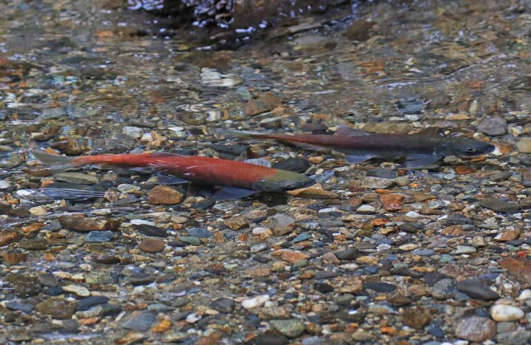
Photo: Judy Gallagher, CC BY 2.0
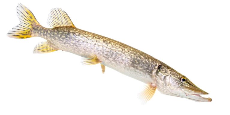
Photo: USFWS Mountain-Prairie, Public domain
Reservoirs, creeks and launches of Uintah County, explained
Which Utah launches serve Uintah County?
14 launches show up in the launch data for the county.
Where is the widest reservoir in Uintah County?
Pelican Lake leads with 1560.
What fish turn up on Fish Utah pages near Uintah County?
Fish Utah rates rainbow trout likely or possible on the most lakes within 40 miles, then tiger trout, brown trout and bluegill.
Which Uintah County stores sell Utah fishing gear?
Sportsman's Warehouse, 2015 W Highway 40 heads a list of 2.
Where does the Utah county of Uintah County keep its courthouse?
Vernal has it.
What does a Utah fishing license cost for Uintah County?
Utah prices its adult 365-day fishing license at $40 for residents and $120 for visitors, unchanged between the two guidebooks.
Which Utah counties should I check near Uintah County?
The closest county pages are Duchesne County, Daggett County and Carbon County.
How many trout may an angler in Uintah County take home?
Statewide, the trout, kokanee and grayling row sets a daily limit 4 under the 2027 guidebook; the 2026 guidebook prints the same number. Waters with their own entry can differ.
Does the guidebook list exceptions for Uintah County water?
8 waters with a page here carry their own rules, beginning with Calder Reservoir.
Did hatchery trucks visit Uintah County this year?
The 2026 DWR table lists 67,641 fish in 56 rows across 26 waters in the county.
Which DWR records tie to Uintah County?
Bluegill, 11 ⅝", from Pelican Lake (2007).
Plan a Beehive State day in Uintah County
Lake pages carry launches, DWR species lists and dated guidebook rules.