Fishing in Wheeler County, Oregon
County seat: Fossil. Population 1,451.
- 4lake pages
- 11open launches
- 1river pages
 Pick for rainbow troutPiscifun Carbon X ultralight spinning reel28% OFFSale $57.99
Photo of Deschutes River: Bonnie Moreland, Public domain
Wheeler County fishing at a glance
County business for Wheeler County happens in Fossil; the 2020 Census found 1,451 residents. Expect the ODFW Northeast Zone limits on most Wheeler County waters; zones are drawn by drainage, so check any water near a divide.
Of the 4 lake guides tied to Wheeler County, Fopiano Reservoir covers the most surface. The Marine Board layer shows 11 open launches inside the county, 6 for trailers.
Census 2020 population; BLM Oregon NHD lake outlines; OSMB Boating Access Sites; DLCD and ODFW shore access layers; 2026 Oregon Sport Fishing Regulations zone lists; read November 2, 2026.
Pinning the fishing access in Wheeler County
OSMB launch points, DLCD and ODFW shore sites, NHD lake points, PMEP estuary points; read November 2, 2026.
Lake guides for Wheeler County
| Lake | Acres | Kind | OSMB launches | Fish mapped |
|---|---|---|---|---|
| Fopiano Reservoir | 30 (outline) | reservoir | 0 | rainbow trout |
| Collins Reservoir | 19 (outline) | reservoir | 0 | rainbow trout |
| Rowe Creek Reservoir | 18 (outline) | reservoir | 0 | rainbow trout |
| Blann Meadow Reservoir | 11 (outline) | reservoir | 0 | rainbow trout |
BLM Oregon hydrography lake outlines (NHD), summed by GNIS name (layer), read November 2, 2026. Species: ODFW Fish Habitat Distribution layers (ODFW ArcGIS), read November 2, 2026; a mapped species is habitat use ODFW records, not a catch report. ODFW publishes no lake depths in these layers.
 For the rainbow trout herePiscifun Carbon XT ultralight spinning reel25% OFFSale $59.99
Fish counts across waters by Wheeler County
Out to 40 miles from Fossil, rainbow trout appears on more water pages than any other species.
Species from ODFW Fish Habitat Distribution layers, booklet exceptions and ODFW records, counted per water page within 40 miles; habitat mapping, not a catch survey.
More lake outlines across Wheeler County
Another 4 named outlines fall in Wheeler County.
| Water | Acres (outline) | Nearest place |
|---|---|---|
| Rock Creek Lake | 76 | John Day |
| Painted Hills Reservoir | 47 | Prineville |
| Fort Creek Reservoir | 38 | John Day |
| Wineland Lake | 13 | Heppner |
BLM Oregon hydrography lake outlines (NHD), summed by GNIS name (layer), read November 2, 2026.
Streams that cross Wheeler County
- John Day River18 OSMB launches, 3 USGS gauges, 20 booklet exceptions
River readings across Wheeler County
| USGS gauge | Latest reading | Time (ET) |
|---|---|---|
| John Day River At Service Creek, Or | 246 cfs, 2.11 ft gage height | Nov 11 8:30 pm |
| Bridge Cr Abv Coyote Canyon Nr Mitchell, Or | 2 cfs, 0.94 ft gage height | Nov 11 8:30 pm |
US Geological Survey provisional data, retrieved Nov 11, 2026 9:33 pm ET. Provisional readings can be revised.
ODFW Fish Habitat Distribution stream names and runs, OSMB launches, booklet exceptions and USGS gauges; read November 2, 2026.
Launches listed for Wheeler County
- Clarno East launch on John Day RiverJohn Day River, hand carry launch
- Clarno State Recreation Site boat ramp on John Day RiverJohn Day River, 1 lane, trailered launch
- Kimberly boat ramp on John Day RiverJohn Day River, 1 lane, trailered launch
- Lower Burnt Ranch launch on John Day RiverJohn Day River, hand carry launch
- Muleshoe Boat Launch on John Day RiverJohn Day River, 1 lane, trailered launch
- Priest Hole Recreation Site boat ramp on John Day RiverJohn Day River, 1 lane, trailered launch
- Service Creek Boat Launch on John Day RiverJohn Day River, 1 lane, hand carry launch
- Shady Grove boat ramp on John Day RiverJohn Day River, 1 lane, trailered launch
- Spray Riverfront Park on John Day RiverJohn Day River, 1 lane, hand carry launch
- Twickenham launch on John Day RiverJohn Day River, 1 lane, hand carry launch
- Wooden Bridge boat ramp on John Day RiverJohn Day River, 1 lane, trailered launch
OSMB status is shown as published: closed launches are listed without a page.
Oregon State Marine Board Boating Access Sites layer (OSMB ArcGIS), read November 2, 2026; status as OSMB publishes it. Oregon Coastal Management Program (DLCD) Shoreline Access Inventory (layer) and the ODFW shore access map, read November 2, 2026.
Bait a drive from Wheeler County
- Deschutes Angler Fly Shopfly shop, Maupin, 44 miles
- Deschutes Canyon Fly Shopfly shop, Maupin, 44 miles
- Brads Bait and Tacklebait and tackle shop, Madras, 52 miles
- Bi-Mart (Madras)sporting goods store, Madras, 52 miles
- Gorge Outfitters Supplybait and tackle shop, Rufus, 54 miles
Yellow Pages and store-locator listings; straight-line miles from Fossil.
ODFW stocking for waters of Wheeler County
Across 1 stocked waters in Wheeler County, ODFW plans 2 releases and 1,300 trout.
- Rowe Creek Reservoir2 releases planned, next listed: May. 03, 2027 – May. 07, 2027: 650 legal-size trout
ODFW weekly trout stocking schedule (planned releases; ODFW prints size classes, not species), myodfw.com, read November 2, 2026.
Keeper rules across Wheeler County
The zone rows apply across Wheeler County wherever no water exception steps in. Annual angling runs $50 for residents of Oregon and $138 for everyone else in 2026. Keep a salmon or steelhead and you need the Combined Angling Tag too, $69 for residents.
| Species | Limit | Season |
|---|---|---|
| Trout | Lakes: 5 per day, 3 daily limits in possession. Streams: 2 per day, 3 daily limits in possession; 8-inch minimum | Lakes: Open all year. Streams: Open May 22 – Oct 31, unless noted under Exceptions. |
| Kokanee | 10 per day unless noted under Exceptions. | Open all year. |
| Salmon | See Umatilla River under Exceptions. There is no annual limit on hatchery salmon as long as the appropriate number of Hatchery Harvest Tags have been purchased to record the catch. | Closed in all waters unless noted by species under Exceptions. |
| Steelhead | 3 per day. | Closed in all waters unless noted by species under Exceptions. |
| Sturgeon | Catch-and-release only. | Lakes: Open all year. Streams: Open during trout, salmon or steelhead seasons only, except portions of Columbia River tributaries flooded by John Day and. |
| Bass | Lakes: 5 per day, 3 daily limits in possession unless noted under Exceptions. Streams: No limit. | Lakes: Open all year. Streams: Open during trout, salmon or steelhead seasons only, except portions of Columbia River tributaries flooded by John Day and. |
| Bluegill, Catfish, Crappie, Other Sunfish, Walleye, Yellow Perch, Suck. | No limit. | Lakes: Open all year. Streams: Open during trout, salmon or steelhead seasons only, except portions of Columbia River tributaries flooded by John Day and. |
Special rows reaching Wheeler County (20)
| Water | Species | Rule | Booklet |
|---|---|---|---|
| John Day River (Clatsop Co.) | hatchery steelhead, chinook, salmon | Open all year for hatchery steelhead and hatchery Chinook salmon. | p. 28 |
| John Day River (Clatsop Co.) | Use of bait allowed. | p. 28 | |
| John Day River (Mainline railroad bridge to North Fork) | hatchery steelhead | Open for hatchery steelhead Jan 1 – Apr 30 and Sept 1 – Dec 31. | p. 59 |
| John Day River (Mainline railroad bridge to North Fork) | bass, catfish, warmwater | Open all year for bass, catfish, and other warmwater fish. | p. 59 |
| John Day River (Mainline railroad bridge to North Fork) | Use of bait allowed. | p. 59 | |
| John Day River (Mainline railroad bridge to North Fork) | Closed from ODFW marker ¼ mi below Tumwater Falls to 200 ft above the falls near the head of John Day Arm. | p. 59 | |
| John Day River (Mainline railroad bridge to North Fork) | steelhead, salmon | Closed to Salmon and Steelhead angling from Sep 1 – Dec 31 from Mainline railroad bridge to ODFW marker 1/4 mi below Tumwater Falls. | p. 59 |
| John Day River (North Fork to Indian Cr) | hatchery steelhead | Open for hatchery steelhead Jan 1 – Apr 30 and Sep 1 – Dec 31. | p. 59 |
| John Day River (North Fork to Indian Cr) | Use of bait allowed. | p. 59 | |
| John Day River (Above Indian Cr) | Use of bait allowed. | p. 59 | |
| John Day River, Middle Fork (Mouth to Hwy 395 bridge) | hatchery steelhead | Open for hatchery steelhead Jan 1 – Apr 30 and Sep 1 – Dec 31. | p. 60 |
| John Day River, Middle Fork (Mouth to Hwy 395 bridge) | Use of bait allowed. | p. 60 | |
| John Day River, Middle Fork (Above Hwy 395 bridge) | Use of bait allowed. | p. 60 | |
| John Day River, Middle Fork (Above Hwy 395 bridge) | Hook-gap size may not exceed 3/8 inch. | p. 60 | |
| John Day River, Middle Fork (Above Hwy 395 bridge) | Closed from Hwy 7 to Summit Cr. | p. 60 | |
| John Day River, North Fork (Mouth to Hwy 395 bridge) | hatchery steelhead | Open for hatchery steelhead Jan 1 – Apr 30 and Sep 1 – Dec 31. | p. 60 |
| John Day River, North Fork (Mouth to Hwy 395 bridge) | Use of bait allowed. | p. 60 | |
| John Day River, North Fork (Hwy 395 bridge to USFS North Fork Campground) | Use of bait allowed. | p. 60 | |
| John Day River, North Fork (Hwy 395 bridge to USFS North Fork Campground) | Hook-gap size may not exceed 3/8 inch. | p. 60 | |
| John Day River, North Fork (Above North Fork Campground) | Use of bait allowed. | p. 60 |
Limits as printed in the 2026 Oregon Sport Fishing Regulations (ODFW, eRegulations edition) (Northeast Zone page), read November 2, 2026. Water exceptions as printed in the 2026 Oregon Sport Fishing Regulations (ODFW, eRegulations edition) (booklet PDF; printed page shown), read November 2, 2026. In-season changes from ODFW override them. Fees as printed on the ODFW license, tag and permit fee page of the 2026 Oregon Sport Fishing Regulations (ODFW, eRegulations edition) (fees page), read November 2, 2026.
State records from water by Wheeler County
Neighbouring waters, all within 80 miles of Wheeler County, hold these records.
| Species | Weight | Water | Date |
|---|---|---|---|
| Brook Trout | 9 lb 6 oz | Deschutes River | 1980 |
| Mountain Whitefish | 5 lb 12 oz | Deschutes River | 2021 |
| Bull Trout | 23 lb 2 oz | Lake Billy Chinook | 1989 |
Oregon record fish as listed by Oregon Department of Fish and Wildlife (record fish article, dated March 4, 2026), read November 2, 2026.
In range of Wheeler County
Counties next to Wheeler County
- Crook County43 miles southwest
- Gilliam County46 miles north
- Morrow County52 miles northeast
- Grant County53 miles east
What Piscifun sells for a day spent on Wheeler County


Piscifun and Amazon links are affiliate links; the site earns a commission on qualifying purchases.
Know the Wheeler County catch by sight
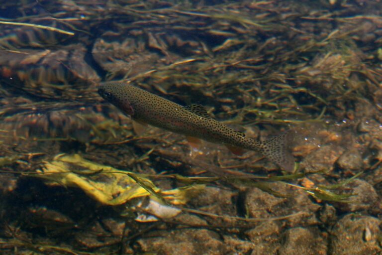
Photo: Alaska Region U.S. Fish & Wildlife Service, Public domain
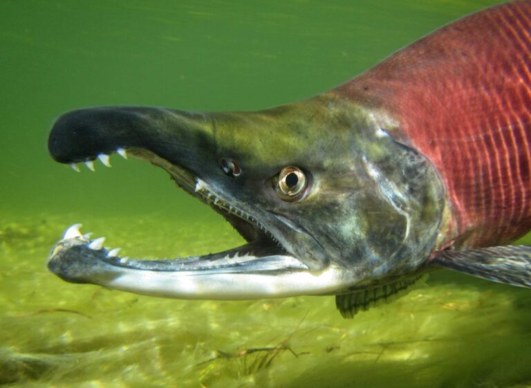
Photo: USFWS Mountain-Prairie, CC BY 2.0

Photo: gailhampshire, CC BY 2.0
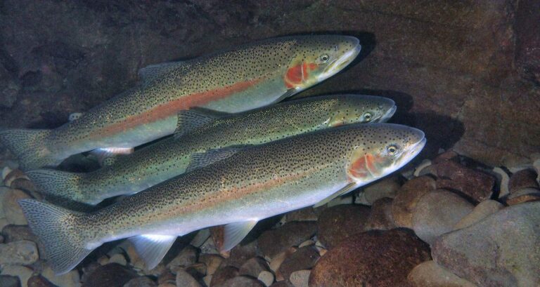
Photo: Oregon State University, CC BY-SA 2.0
Your Wheeler County fishing questions, answered
How many boat launches are open in Wheeler County?
11 open launches on the OSMB layer, 6 of them for trailers.
Which reservoir or lake tops Wheeler County by size?
Fopiano Reservoir, about 30 acres on its mapped outline.
Which fish lead the water pages near Wheeler County?
Rainbow trout lead the count of water pages within 40 miles, then brook trout, chinook salmon and steelhead.
Which Wheeler County stores stock salmon and trout tackle?
The listings show no shop in the county.
Is there a drift-boat or fishing guide listed in Wheeler County?
No guide gives an address here.
Which town is the administrative centre for Wheeler County?
It is Fossil.
Do I need a license for water in Wheeler County?
Oregon residents pay $50 for the annual angling license, visitors $138. Salmon, steelhead, sturgeon and halibut also go on a Combined Angling Tag ($69 resident).
Which counties touch Wheeler County?
Start with Crook County, Gilliam County and Morrow County.
What zone table do Wheeler County waters use?
The ODFW Northeast Zone rows cover most of the listed water in Wheeler County; a drainage that crosses the line can carry another zone.
Which Wheeler County waters get their own booklet rows?
The 2026 booklet prints 20 water exceptions reaching this county, starting with John Day River (Clatsop Co.); the table above shows each.
How many Wheeler County waters are on the stocking schedule?
Yes: 1 water on the ODFW schedule, such as Rowe Creek Reservoir; releases are planned, not confirmed.
Plan a day on the water in Wheeler County
Every launch page opens with directions.