Fishing near Terre Haute, Indiana
Vigo County, population 58,389 (2020 Census).
- under a mileto nearest lake page
- 8ramps nearby
 Pick for redear sunfishPiscifun Carbon X ultralight spinning reel28% OFFSale $57.99
Photo: Paul Sableman, CC BY 2.0
Fishing out of Terre Haute
58,389 people lived in the city of Terre Haute (Vigo County) at the 2020 count. Head east under a mile to reach Deming Park Front Pond, the closest lake page. Burns Lake spreads over 19 acres (NHD outline area), more than any lake nearby. Fairbanks Park on Wabash River is the closest DNR boat ramp, 2 miles out.
Shore fishing waits at Deming Park on Deming Park Front Pond, under a mile from town.
Census 2020 population and Gazetteer point for Terre Haute; miles are straight lines.
Close lakes for Terre Haute anglers
| Lake | Distance | Area | Max depth | Kind | Ramps | Fish the DNR names |
|---|---|---|---|---|---|---|
| Deming Park Front Pond | under a mile east | pond | 0 | bluegill, redear sunfish, common carp | ||
| Deming Park Back Pond | 1 mile east | pond | 0 | largemouth bass, bluegill, channel catfish | ||
| Dobbs Park Pond | 2 miles east | pond | 0 | bluegill, redear sunfish, catfish | ||
| Maple Avenue Lake | 3 miles northwest | lake | 1 | bluegill, largemouth bass, trout | ||
| Burns Lake | 3 miles northeast | 19 acres (NHD outline area) | lake | 1 | bluegill, redear sunfish, catfish | |
| J.I. Case Marsh | 4 miles northeast | lake | 1 | bluegill, redear sunfish, catfish |
Acres are the NHD outline area of the mapped lake (USGS National Hydrography Dataset via IndianaMap), not a DNR survey figure. Depths from DNR Status & Trends surveys with the survey year. Indiana DNR Fishing Access Sites layer (shown on the DNR Where to Fish map; attributes as recorded, blank where not recorded), read November 5, 2026.
 For the redear sunfish herePiscifun Carbon XT ultralight spinning reel25% OFFSale $59.99
Flowing water close to Terre Haute
River stage around Terre Haute
| USGS gauge | Latest reading | Time (ET) |
|---|---|---|
| Wabash River At Terre Haute, In | 5,020 cfs, 5.66 ft gage height | Nov 6 9:30 pm |
| Sugar Creek At West Terre Haute, In | 5 cfs, 1.53 ft gage height | Nov 6 9:45 pm |
| Big Raccoon Creek At Coxville, In | 521 cfs, 6.91 ft gage height | Nov 6 9:45 pm |
US Geological Survey provisional data, retrieved Nov 6, 2026 10:33 pm ET. Provisional readings can be revised.
NHD named flowlines, DNR river designations and USGS gauges (live readings); read November 5, 2026.
Mapped ramps and lakes by Terre Haute
- Fairbanks Park on Wabash RiverWabash River, concrete ramp, fishing pier, courtesy dock, ADA access, restrooms, lights, no fee recorded, 2 miles
- Maple Avenue Nature ParkMaple Avenue Lake, boat ramp, restrooms, lights, no fee recorded, Electric only, 3 miles
- Hawthorn County Park on Burns LakeBurns Lake, boat ramp, courtesy dock, restrooms, lights, no fee recorded, Electric only, 3 miles
- J.I. Case Marsh boat rampJ.I. Case Marsh, concrete ramp, fishing pier, lights, no fee recorded, Electric only, 4 miles
- Robert Hunter Kearns boat ramp on Wabash RiverWabash River, concrete ramp, no fee recorded, 7 miles
- Green Valley PFA boat rampGreen Valley Lake, concrete ramp, fishing pier, restrooms, no fee recorded, Electric only, 8 miles
- W. Keith Ruble Lake boat rampW. Keith Ruble Lake, concrete ramp, fishing pier, courtesy dock, ADA access, restrooms, lights, no fee recorded, Electric only, 9 miles
- Little George Pit boat rampLittle George Pit, boat ramp, no fee recorded, Electric only, 9 miles
Walk-up fishing by Terre Haute
- Deming Park on Deming Park Front Pondfishing pier, restrooms, lights, no fee recorded, under a mile
- Deming Park on Deming Park Back Pondshore access, restrooms, lights, no fee recorded, 1 mile
- Dobbs Park Pondfishing pier, restrooms, lights, no fee recorded, 2 miles
- Dobbs Park Pond (Dobbs Park)urban fishing site, 2 miles
- Maple Avenue Park Lake (Maple Avenue Park)urban fishing site, 3 miles
- Bell Pond shore accessshore access, no fee recorded, 4 miles
Indiana DNR Fishing Access Sites layer (shown on the DNR Where to Fish map; attributes as recorded, blank where not recorded), read November 5, 2026.
Dated pool readings by Terre Haute
- Cecil M Harden Lake652.56 ft pool, 26 miles, read 2026-11-05 19:15:00 UTC
- Cagles Mill Lake637.53 ft pool, 26 miles, read 2026-11-05 19:15:00 UTC
Dated pool figures only, copied at build time.
USACE Louisville District pool as reported through the NOAA National Water Prediction Service gauge CHLI3, read November 5, 2026 (one dated reading, not live; feet as published, datum not printed).
Supplies and guides around Terre Haute
Tackle counters nearest Terre Haute
- Dick's Sporting Goods Terre Haute, 3500 S. Us Hwy 41sporting goods store, Terre Haute, 3 miles
- Academy Sports + Outdoors Terre Hautesporting goods store, Terre Haute, 4 miles
- Dick's Sporting Goods Terre Haute, 4700 S Us Hwy 41sporting goods store, Terre Haute, 4 miles
- Jack's Bait Tackle & Morebait and tackle shop, Brazil, 12 miles
Yellow Pages, chain store and DNR property listings (miles only for shops with an exact point); DNR licensed guide list and tourism bureau charter listings; read November 5, 2026.
Record Fish Program catches by Terre Haute
| Species | Weight | Water | County | Year |
|---|---|---|---|---|
| Goldeye | 2 lb. 4.8 oz. | Wabash River | Vermillion County | 2008 |
| Shortnose Gar | 2 lb. 15.9 oz. | Wabash River | Tippecanoe County | 2025 |
| Shovelnose Sturgeon | 14 lb. 8 oz. | Wabash River | Fountain County | 1999 |
| Skipjack Herring | 2 lb. 8.2 oz. | Wabash River | Carroll County | 2021 |
Indiana DNR Indiana Record Fish Program list (keeper: Indiana DNR Division of Fish & Wildlife (Indiana Record Fish Program); angler names left off here), read November 5, 2026. Waters within 40 miles.
Statewide limits near Terre Haute
An annual DNR fishing license runs $23 for residents and $60 for nonresidents, under-18s exempt.
| Species | Daily limit | Size limit |
|---|---|---|
| Bluegill | Unlimited | no size limit |
| Redear Sunfish | 25 | no size limit |
| Black Bass: largemouth, smallmouth, and spotted bass (in lakes) | 5, any combination of largemouth, smallmouth, or spotted bass | 14 inches |
| Black Bass: largemouth, smallmouth, and spotted bass (in rivers and streams) | 5, any combination of largemouth, smallmouth, or spotted bass | No fish 12 to 15 inches may be kept, and no more than two fish over 15 inches may be kept |
| Black Bass: largemouth, smallmouth, and spotted bass (in Lake Michigan) | 3, any combination of largemouth, smallmouth, or spotted bass | 14 inches |
| Yellow Bass | Unlimited | no size limit |
| White Bass, Hybrid Striped Bass | 12, any combination of white bass or hybrid striped bass | No more than two fish may exceed 17 inches |
| Striped Bass | 2 | no size limit |
| Rock Bass | 25 | no size limit |
| Crappie | 25 | no size limit |
| Walleye, Walleye-Sauger Hybrid (Saugeye), Sauger | 6, any combination of walleye, walleye-sauger hybrid, and sauger | For walleye: 14 inches south of SR 26; 16 inches north of SR 26 For sauger and saugeye: No size limit |
| Muskellunge and Tiger Muskellunge | 1 muskellunge or 1 tiger muskellunge | 36 inches |
| Northern Pike | 3 | 24 inches; no more than one 30 inches or longer |
| Yellow Perch | Unlimited (15 only on Lake Michigan) | no size limit |
| Catfish: Channel, Blue, Flathead (in rivers and streams) | Unlimited | 13 inches; not more than one blue catfish that’s at least 35 inches, one flathead catfish at least 35 inches, and one channel catfish at least 28 inches or longer may be kept |
| Catfish: Channel, Blue, Flathead (in lakes) | 10 | None; not more than one blue catfish that’s at least 35 inches, one flathead catfish at least 35 inches, and one channel catfish at least 28 inches or longer may be kept |
| Bullhead | Unlimited | no size limit |
| Shovelnose Sturgeon | Unlimited | 25 inches (fork length) |
Statewide limits as printed, 2026-2027 Indiana Fishing Regulations Guide (eRegulations, linked from the Indiana DNR), read November 5, 2026. Lake and river pages print any special regulation entry. Indiana DNR license fees (license year April 1 to March 31), read November 5, 2026.
Around Terre Haute
Nearby towns with their own page, from Terre Haute
- West Terre Haute4 miles
- North Terre Haute5 miles
- Seelyville6 miles
- Clinton14 miles
- Brazil14 miles
County page that takes in Terre Haute
- Vigo Countyseat: Terre Haute
Piscifun tackle for the next run to Terre Haute


Piscifun and Amazon links are affiliate links; the site earns a commission on qualifying purchases.
Fish to know on sight at Terre Haute
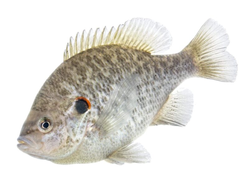
Photo: USFWS Mountain-Prairie, Public domain
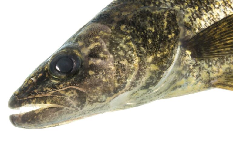
Photo: USFWS Mountain-Prairie, Public domain

Photo: USFWS Mountain-Prairie, Public domain
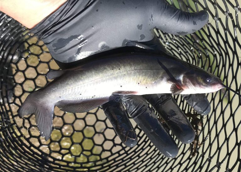
Photo: Oregon Department of Fish & Wildlife, CC BY-SA 2.0
Asked about fishing near Terre Haute
Which lake does a Terre Haute angler hit first?
Deming Park Front Pond, under a mile east.
How long is the tow from Terre Haute to a ramp?
Roughly 2 miles out, at Fairbanks Park on Wabash River.
Where can a Terre Haute angler fish from shore?
Deming Park on Deming Park Front Pond is the pick at under a mile.
Where do Terre Haute anglers drive for tackle?
Dick's Sporting Goods Terre Haute is listed 3 miles from town.
Which county page lists Terre Haute among its towns?
Vigo County.
What does a visitor staying in Terre Haute pay to fish?
Nonresidents spend $60 on the annual Indiana license, or $15 for a single day.
Which big lake sits in range of Terre Haute?
Burns Lake maps at 19 acres (NHD outline area) and lies 3 miles off.
Which other Indiana towns could host a Terre Haute trip?
Look at West Terre Haute (4 miles), North Terre Haute (5 miles) and Seelyville (6 miles).
Does water near Terre Haute show up on the record list?
Goldeye, 2 lb. 4.8 oz., 2008, from Wabash River.
Try the reservoirs near Terre Haute this year
Check a water's special rules before keeping fish.