Lost River Fishing
Martin, Orange and Washington counties carries this river; NRC Outstanding River (2013 list).
 Pick for largemouthPiscifun Chaos Pro CNC baitcasting reel25% OFFSale $97.99
Photo of Patoka Lake: Deana Hunter, CC BY 2.0
The Lost River on the Indiana map
The NHD map gives the Lost River 78 miles of line within Indiana, across Martin, Orange and Washington counties. Its state status: NRC Outstanding River (2013 list). The handiest town is French Lick, around 5 miles away.
Flow comes from 1 USGS gauge.
USGS NHD named flowlines (mapped length in Indiana, not a DNR figure); Indiana DNR stream designation layers and Fishing Access Sites, read November 5, 2026.
State designations on the Lost River
- DesignationNRC Outstanding River (2013 list)
- Reach as listedPotato Road to confluence with East Fork White River
- Navigableon the Indiana navigable waterways list
These the Lost River rows repeat state list text.
Natural Resources Commission Outstanding Rivers list (2013), DNR put-and-take and salmonid stream layers, Indiana navigable waterways list; read November 5, 2026.
Today's height and speed of the Lost River
| USGS gauge | Latest reading | Time (ET) |
|---|---|---|
| Lost River Near Prospect, In | 85 cfs, 8.88 ft gage height | Nov 6 11:15 pm |
US Geological Survey provisional data, retrieved Nov 6, 2026 11:34 pm ET. Provisional readings can be revised.
Provisional live values from USGS on the Lost River.
NOAA gauge readings on the Lost River
| NWS gauge | Reading | Flow | Flood category | Time (UTC) |
|---|---|---|---|---|
| Lost River (IN) near Prospect | 8.81 ft | – | not defined | 2026-11-05 19:15:00 UTC |
NOAA National Water Prediction Service gauge readings (water.noaa.gov), read November 5, 2026; dated readings, not live (kcfs = thousand cubic feet per second).
USGS instantaneous values, provisional.
DNR access points along the Lost River
The Lost River has no DNR-mapped access point.
Other ramps if Lost River is busy
- Springs Valley Lake (Tucker Lake) boat rampSprings Valley Lake, 8 miles
- Painter Creek Ramp on Patoka LakePatoka Lake, 12 miles
- Shoals boat ramp on East Fork White RiverEast Fork White River, 12 miles
- Jackson boat ramp on Patoka LakePatoka Lake, 13 miles
Indiana DNR Fishing Access Sites layer (shown on the DNR Where to Fish map; attributes as recorded, blank where not recorded), read November 5, 2026.
Indiana limits in force on the Lost River
| Species as printed | Daily limit | Size limit |
|---|---|---|
| Black Bass: largemouth, smallmouth, and spotted bass (in rivers and streams) | 5, any combination of largemouth, smallmouth, or spotted bass | No fish 12 to 15 inches may be kept, and no more than two fish over 15 inches may be kept |
| Catfish: Channel, Blue, Flathead (in rivers and streams) | Unlimited | 13 inches; not more than one blue catfish that’s at least 35 inches, one flathead catfish at least 35 inches, and one channel catfish at least 28 inches or longer may be kept |
| Bluegill | Unlimited | no size limit |
| Redear Sunfish | 25 | no size limit |
| White Bass, Hybrid Striped Bass | 12, any combination of white bass or hybrid striped bass | No more than two fish may exceed 17 inches |
| Walleye, Walleye-Sauger Hybrid (Saugeye), Sauger | 6, any combination of walleye, walleye-sauger hybrid, and sauger | For walleye: 14 inches south of SR 26; 16 inches north of SR 26 For sauger and saugeye: No size limit |
| Northern Pike | 3 | 24 inches; no more than one 30 inches or longer |
The guide treats the Lost River as moving water for bass and catfish limits.
Anglers 18 and older carry an Indiana fishing license ($23 a year for residents, $60 for nonresidents).
Statewide limits as printed, 2026-2027 Indiana Fishing Regulations Guide (eRegulations, linked from the Indiana DNR), read November 5, 2026. Indiana DNR license fees (license year April 1 to March 31), read November 5, 2026.
 For the largemouth herePiscifun AlinoX 300 low profile baitcaster34% OFFSale $104.99
The Lost River and its closest neighbours
East Fork White River sits near 14 miles from the Lost River, the closest listed.
| Stream | Distance | Mapped NHD miles in IN | USGS gauges | DNR ramps |
|---|---|---|---|---|
| Lost River | this stream | 78 | 1 | 0 |
| East Fork White River | 14 miles northeast | 182 | 4 | 15 |
| Blue River (Crawford and Harrison Counties) | 25 miles southeast | 72 | 2 | 4 |
| Little Blue River (Crawford County) | 27 miles south | 34 | 0 | 0 |
| West Fork Blue River | 27 miles east | 14 | 1 | 0 |
| Stinking Fork | 27 miles south | 13 | 0 | 0 |
USGS NHD and gauges, Indiana DNR Fishing Access Sites; read November 5, 2026.
Around the edges of Lost River
Lakes in the same part of Indiana as Lost River
- Springs Valley Lake9 miles
- Martin Lake (Martin County)10 miles
- Hardwood Lake10 miles
- Pine Lake (Martin County)11 miles
Picking up nightcrawlers and minnows near Lost River
- Patoka Lake Boat and Marinebait and tackle shop, French Lick, 11 miles
- Krb Bait & Tacklebait and tackle shop, Shoals, 12 miles
- White River Bait & Tacklebait and tackle shop, Williams, 14 miles
- Hoosier Hills Marinamarina, Celestine, 16 miles
- Gilligan's Boatsmarina, Birdseye, 17 miles
- Patoka Lake Marinamarina, Birdseye, 17 miles
Hoosier towns sitting near Lost River
- French Lick5 miles
- Paoli7 miles
- Orleans8 miles
One more river beside the Lost River
- East Fork White River14 miles
- Blue River (Crawford and Harrison Counties)25 miles
- Little Blue River (Crawford County)27 miles
- West Fork Blue River27 miles
- Stinking Fork27 miles
County guides tied to Lost River
- Martin County
- Orange County
- Washington County
Piscifun picks for a day out on Lost River


Piscifun and Amazon links are affiliate links; the site earns a commission on qualifying purchases.
Telling Lost River fish apart from a photo
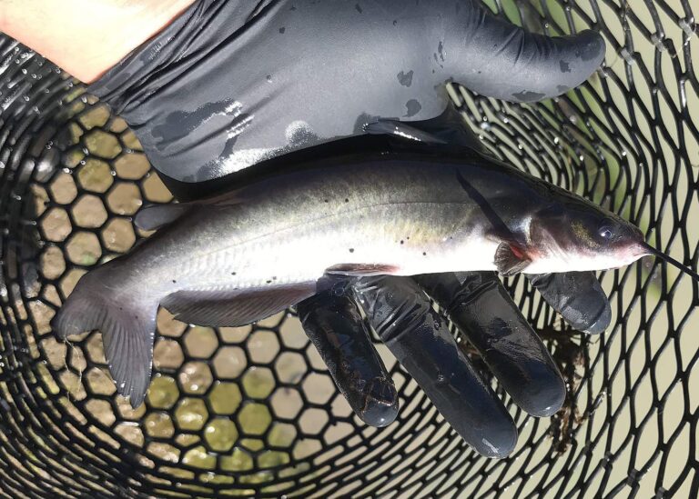
Photo: Oregon Department of Fish & Wildlife, CC BY-SA 2.0
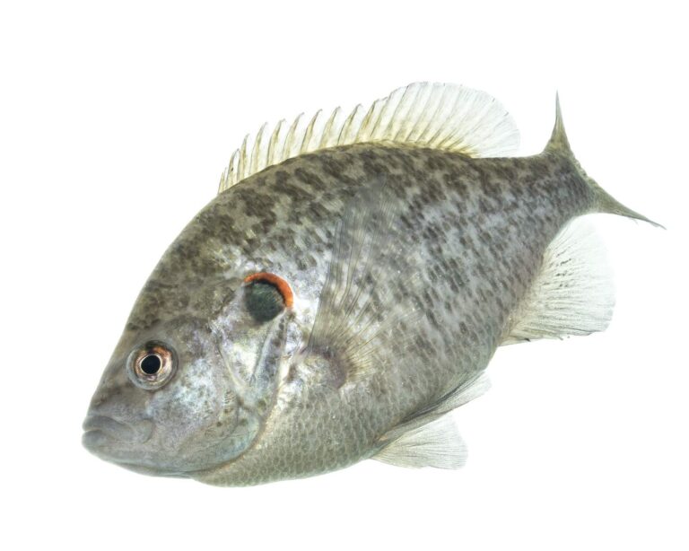
Photo: USFWS Mountain-Prairie, Public domain
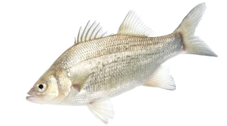
Photo: USFWS Mountain-Prairie, Public domain

Photo: USFWS Mountain-Prairie, Public domain
Things Indiana anglers ask about the Lost River
Which town is near the Lost River?
It runs through Martin, Orange and Washington counties, and its mapped point is about 5 miles from French Lick.
Is the Lost River a long river?
The NHD map shows 78 miles of line in Indiana; that is a mapping figure, not a DNR survey.
How do I get onto the Lost River?
No public site is mapped on it.
Which species does the DNR list for the Lost River?
DNR layers leave its species blank.
How many black bass may an Indiana angler keep from the Lost River?
The guide row for rivers and streams reads: 5, any combination of largemouth, smallmouth, or spotted bass; No fish 12 to 15 inches may be kept, and no more than two fish over 15 inches may be kept
Can I fish the Lost River without paying a fee to the state?
Anglers 18 and older carry an Indiana fishing license ($23 a year for residents, $60 for nonresidents).
Who measures the Lost River?
USGS gauge Lost River Near Prospect, IN reports live; see the flow band.
Is there a bait shop by the Lost River?
Our list starts with Patoka Lake Boat and Marine, about 11 miles away,.
Is the Lost River a trout stream?
State lists name it: NRC Outstanding River (2013 list).
Plan a float down the Lost River
Fees, stamps and river rules sit on one page.