Fishing in Valley County, Idaho
County seat: Cascade. Population 11,746.
- 26lake pages
- 8launch sites
- 12river pages
 Pick for salmonPiscifun Viper X spinning reel50% OFFSale $39.99
Photo of North Fork Payette River: BLMIdaho, CC BY 2.0
Reservoirs, creeks and launches of Valley County at a glance
Valley County keeps its courthouse in Cascade, and the 2020 Census put 11,746 people inside the county. The IDFG Fishing Planner files 93% of the county's listed waters under the IDFG Southwest Region; drainage lines, not the county line, decide the rest. The Planner also lists 170 high mountain lakes here, most reached by trail.
Lake guides cover 26 waters totalling 38,970 acres; Cascade Reservoir is the biggest. Ocean-run fish show up on the game fish lists of Middle Fork Salmon River, South Fork Salmon River, Bear Valley Creek and East Fork South Fork Salmon River. Agency maps show 8 launch sites (5 Forest Service and 3 IDFG). IDFG maps 4 walk-in access sites for anglers on foot.
Census 2020 population and county seat; IDFG Idaho Fishing Planner (list of Idaho waters), read November 7, 2026. IDFG Fishing and Boating Access Sites layer (ArcGIS service), read November 7, 2026.
 For the salmon herePiscifun AlumiX spinning reel46% OFFSale $64.99
A map of Valley County launches and lake points
IDFG Fishing and Boating Access Sites, BLM and Forest Service launch points, Fishing Planner lake points (outlet) and stream midpoints. Checked November 2026.
Valley County lakes and reservoirs with their own page
| Lake | Acres | Launches | Kind | Game fish IDFG names |
|---|---|---|---|---|
| Cascade Reservoir | 27,152 | 3 | reservoir | bluegill and sunfish, bullhead, kokanee |
| Payette Lake | 4,987 | 0 | lake | kokanee, lake trout, cutthroat trout |
| Deadwood Reservoir | 2,997 | 0 | reservoir | kokanee, chinook salmon, cutthroat trout |
| Little Payette Lake | 1,440 | 1 | lake | kokanee, smallmouth bass, rainbow trout |
| Warm Lake | 412 | 1 | lake | kokanee, lake trout, brook trout |
| Upper Payette Lake | 302 | 0 | lake | brook trout, rainbow trout, largescale sucker |
| Horsethief Reservoir | 258 | 1 | reservoir | brown trout, rainbow trout, kokanee |
| Sage Hen Reservoir (Gem County) | 232 | 3 | reservoir | rainbow trout |
| Granite Lake (Valley County) | 188 | 0 | lake | cutthroat trout, brook trout, rainbow trout |
| Box Lake | 141 | 0 | high mountain lake | brook trout, rainbow trout, arctic grayling |
| Cruickshank Reservoir | 112 | 0 | reservoir | |
| Loon Lake | 101 | 0 | high mountain lake | brook trout, bull trout, cutthroat trout |
| Browns Pond | 83 | 0 | lake | brook trout, rainbow trout |
| Boulder Lake | 78 | 0 | high mountain lake | cutthroat trout, rainbow trout, cutthroat trout – westslope |
| Riordan Lake | 75 | 0 | high mountain lake | |
| Davis Reservoir | 66 | 0 | reservoir | |
| Hait Reservoir | 63 | 0 | reservoir | |
| Thirtythree Lake | 41 | 0 | high mountain lake | cutthroat trout, lake trout, rainbow trout |
| Caton Lake | 38 | 0 | high mountain lake | |
| Herrick Reservoir | 37 | 1 | reservoir | rainbow trout, yellow perch |
| Nick Lake | 35 | 0 | high mountain lake | cutthroat trout – westslope |
| Blackwell Lake | 34 | 0 | high mountain lake | cutthroat trout, brook trout, rainbow trout |
| Deep Lake | 32 | 0 | high mountain lake | brook trout, brown trout |
| Corral Creek Reservoir | 31 | 0 | reservoir | rainbow trout, yellow perch |
| Boulder Meadows Reservoir | 31 | 0 | reservoir | rainbow trout |
| Tripod Reservoir | 5 | 0 | reservoir | rainbow trout, brook trout, bull trout |
Surface acres as listed in the IDFG Idaho Fishing Planner, read November 7, 2026. Game fish are the Planner’s recommended species; IDFG prints no lake depths there.
Which fish the Planner ties to water near Valley County
Out to 50 miles from Cascade, rainbow trout turns up on the most lake pages.
IDFG Fishing Planner recommended game fish and stocking rows, counted per lake page within 50 miles; not a creel survey.
More named Valley County lakes on the Planner list
Another 178 named lakes in Valley County have too few published facts for a page and are listed here by size.
| Water | Acres | Kind | Nearest town |
|---|---|---|---|
| Upper Jug Creek Reservoir | 26 | reservoir | McCall |
| Louie Lake | 25 | high mountain lake | McCall |
| Brush Lake | 18 | high mountain lake | McCall |
| Long Twentymile Lake | 18 | high mountain lake | McCall |
| Logan Lake | 18 | high mountain lake | McCall |
| Warner Pond | 18 | lake | Cascade |
| Bernard Lake | 18 | high mountain lake | Cascade |
| Hum Lake | 18 | high mountain lake | McCall |
| Blue Lake (Valley County) | 17 | high mountain lake | McCall |
| East Twentymile Lake | 17 | high mountain lake | McCall |
| East Rainbow Lake | 17 | high mountain lake | McCall |
| South Buckhorn Lake | 17 | high mountain lake | McCall |
| Summit Lake | 16 | high mountain lake | McCall |
| East Mountain Reservoir | 16 | reservoir | Cascade |
| Rapid Lake | 16 | high mountain lake | McCall |
| North Twentymile Lake | 16 | high mountain lake | McCall |
| Duck Lake | 16 | high mountain lake | McCall |
| Calendar Reservoir | 16 | reservoir | Cascade |
| Rainbow Lake | 16 | high mountain lake | McCall |
| Buck Lake | 16 | high mountain lake | McCall |
| Tamarack Bay Lake | 16 | high mountain lake | McCall |
| Pistol Lake | 15 | high mountain lake | Cascade |
| Blue Lake (Valley County) | 14 | high mountain lake | Cascade |
| West Rainbow Lake | 14 | high mountain lake | McCall |
| Jungle Lake | 13 | high mountain lake | McCall |
| Victor Lake | 13 | high mountain lake | McCall |
| Koskella Reservoir | 12 | reservoir | Cascade |
| Garand Lake | 12 | high mountain lake | Cascade |
| Marge Lake | 12 | high mountain lake | McCall |
| Golden Lake | 11 | high mountain lake | McCall |
| Square Top Lake | 11 | high mountain lake | McCall |
| North Buckhorn Lake | 11 | high mountain lake | McCall |
| Curtis Lake | 11 | high mountain lake | Cascade |
| Crater Lake | 10 | high mountain lake | McCall |
| Hidden Lake (Valley County) | 10 | high mountain lake | Cascade |
| Long Lake | 10 | high mountain lake | Cascade |
| Sylvan Lake | 9 | high mountain lake | McCall |
| Anderson Lake | 9 | high mountain lake | McCall |
| South Fork Cougar Creek Lake | 9 | high mountain lake | McCall |
| West Duck Lake | 9 | high mountain lake | McCall |
| South Twentymile Lake | 9 | high mountain lake | McCall |
| Trail Lake | 9 | high mountain lake | McCall |
| Malony Lake | 9 | high mountain lake | McCall |
| Pearl Lake | 9 | high mountain lake | McCall |
| Tule Lake | 9 | high mountain lake | Cascade |
| Shirts Lake | 9 | high mountain lake | Cascade |
| Maki Lake | 8 | high mountain lake | McCall |
| Storm Peak Lake | 8 | high mountain lake | McCall |
| Melton Reservoir | 8 | reservoir | McCall |
| Morehead Lake | 8 | high mountain lake | Cascade |
| Skein Lake | 8 | high mountain lake | Cascade |
| Petes Lake | 8 | high mountain lake | McCall |
| WIllow Creek Reservoir | 8 | high mountain lake | Cascade |
| Meadow Creek Lake | 7 | high mountain lake | McCall |
| Cultus Creek Lake | 7 | high mountain lake | McCall |
| Artillery Lake | 7 | high mountain lake | Cascade |
| Shell Rock Lake | 7 | high mountain lake | McCall |
| Raft Lake | 7 | high mountain lake | Cascade |
| Roosevelt Lake | 7 | lake | McCall |
| Cow Lake | 7 | high mountain lake | McCall |
| Black Lake (Valley County) | 7 | high mountain lake | McCall |
| North Lake | 7 | high mountain lake | McCall |
| Lost Lake | 6 | high mountain lake | Cascade |
| Stibnite Pond | 6 | lake | McCall |
| Crystal Lake (Valley County) | 6 | high mountain lake | McCall |
| Bear Valley Dredge Ponds | 6 | lake | Cascade |
| Middle Lake | 6 | high mountain lake | McCall |
| Cougar Lakes | 6 | high mountain lake | McCall |
| North Fork Lick Creek Lake | 6 | high mountain lake | McCall |
| Summit Lake | 6 | high mountain lake | McCall |
| Crestline Lake | 5 | high mountain lake | McCall |
| Lower Granite Lake | 5 | high mountain lake | McCall |
| Artillery Dome Lake | 5 | high mountain lake | Cascade |
| North Fork West Fork Monumental Creek Lake | 5 | high mountain lake | McCall |
| Bear Skin Pond | 5 | high mountain lake | Cascade |
| Lost Lake | 5 | high mountain lake | Cascade |
| Profile Lake | 4 | high mountain lake | McCall |
| Forty-four Lake | 4 | high mountain lake | Cascade |
| Honeymoon Lake | 4 | high mountain lake | Cascade |
| Summit Lake | 4 | high mountain lake | Cascade |
| Lake Mountain Lake | 4 | high mountain lake | Cascade |
| Mud Lake (Valley County) | 4 | high mountain lake | Cascade |
| Ellis Lake | 4 | high mountain lake | McCall |
| Horton Lake | 4 | high mountain lake | McCall |
| Sheepherder Lake | 4 | high mountain lake | Cascade |
| Cruzen Pond | 4 | lake | McCall |
| Rowland Pond | 4 | lake | McCall |
| Slab Butte Lake | 3 | high mountain lake | McCall |
| Sulphur Creek Pond | 3 | high mountain lake | Cascade |
| Burnt Creek Lake | 3 | high mountain lake | Salmon |
| North Loon Mountain Lake | 3 | high mountain lake | McCall |
| Upper Jungle Lake | 3 | high mountain lake | McCall |
| East Fork Lake Fork Creek Lake | 3 | high mountain lake | McCall |
| Fogg Lake | 3 | high mountain lake | McCall |
| Grenade Lake | 3 | high mountain lake | Cascade |
| Yellow Jacket Lake | 3 | high mountain lake | Cascade |
| Little Square Top Lake | 3 | high mountain lake | McCall |
| Marion Lake | 3 | high mountain lake | McCall |
| South Placer Creek Lake | 3 | high mountain lake | McCall |
| Upper Caton Lake | 3 | high mountain lake | McCall |
| Browns Pond | 3 | lake | McCall |
| Dismal Lake | 3 | high mountain lake | McCall |
| Frog Lake | 3 | high mountain lake | McCall |
| Bills Lake | 3 | high mountain lake | McCall |
| Camp Creek Lake | 3 | high mountain lake | McCall |
| East West Fork Elk Creek Lake | 3 | high mountain lake | McCall |
| Chilcoot Lake | 2 | high mountain lake | McCall |
| Indian Creek Lake | 2 | high mountain lake | McCall |
| Lick Lake | 2 | high mountain lake | McCall |
| Lower Jungle Lake | 2 | high mountain lake | McCall |
| Bear Creek Lake | 2 | high mountain lake | Cascade |
| Buck Lake | 2 | high mountain lake | McCall |
| Ditch Creek Lake | 2 | high mountain lake | McCall |
| Johnson Creek Lake | 2 | high mountain lake | Cascade |
| Milk Lake | 2 | high mountain lake | McCall |
| Rice Lake | 2 | high mountain lake | Cascade |
| Stump Lake | 2 | high mountain lake | McCall |
| Vics Lake | 2 | high mountain lake | McCall |
| Wild Horse Creek Lake | 2 | high mountain lake | McCall |
| Fitsum Creek Lake | 2 | high mountain lake | McCall |
Alpine lakes make up 170 of these. Idaho high mountain lakes
IDFG Idaho Fishing Planner (list of Idaho waters), read November 7, 2026.
Rivers and trout creeks of Valley County
- Deadwood RiverIDFG recommended water, 1 launch, 1 USGS gauge, 49.1 mi Planner length
- Middle Fork Salmon RiverIDFG recommended water, steelhead or salmon listed, 105.6 mi Planner length
- North Fork Payette RiverIDFG recommended water
- South Fork Salmon RiverIDFG recommended water, steelhead or salmon listed, 90.3 mi Planner length
- Middle Fork Payette RiverIDFG recommended water, 48.2 mi Planner length
- Bear Valley CreekIDFG recommended water, steelhead or salmon listed, 33.3 mi Planner length
- East Fork South Fork Salmon RiverIDFG recommended water, steelhead or salmon listed, 32.9 mi Planner length
- Sulphur CreekIDFG recommended water, steelhead or salmon listed, 18.6 mi Planner length
- Gold Fork RiverIDFG recommended water, 16.3 mi Planner length
- Lake Fork29.3 mi Planner length
- Secesh Riversteelhead or salmon listed, 28.9 mi Planner length
- Johnson Creek1 USGS gauge, 1.2 mi Planner length
Valley County creeks the Planner names, listed here only (685)
- Chief Eagle Eye Creek60.6 mi
- Big Creek47.5 mi
- Johnson Creek41.7 mi
- Boulder Creek27.3 mi
- Monumental Creek26.2 mi
- Big Creek24.1 mi
- Marble Creek23.2 mi
- Sohoagaiteka’a Naokwaide20.6 mi
- Indian Creek20.3 mi
- Clear Creek20.2 mi
- Pistol Creek18.6 mi
- Elk Creek17.8 mi
- Rush Creek17.6 mi
- Kennally Creek15 mi
- Burntlog Creek14.1 mi
- Little Pistol Creek14 mi
- Bull Creek13.3 mi
- Silver Creek12.8 mi
- Mud Creek12.6 mi
- Big Ramey Creek12.3 mi
- Cave Creek12.3 mi
- Beaver Creek11.4 mi
- Fisher Creek11.1 mi
- Wilson Creek11.1 mi
- Lick Creek11 mi
- North Fork Lake Fork11 mi
- Summit Creek11 mi
- Scriver Creek10.9 mi
- Rapid Creek10.8 mi
- Loon Creek10.6 mi
- Buckhorn Creek10.5 mi
- Pine Creek10.3 mi
- Sheep Creek10.3 mi
- Bearskin Creek10.2 mi
- Caton Creek10.2 mi
- Papoose Creek10 mi
- Riordan Creek9.9 mi
- North Fork Gold Fork River9.8 mi
- Willow Creek9.8 mi
- Beaver Creek9.7 mi
- Fitsum Creek9.7 mi
- Trail Creek (Valley County)9.7 mi
- North Fork Kennally Creek9.5 mi
- Cabin Creek9.3 mi
- Pony Creek9.3 mi
- Trapper Creek9.2 mi
- Warm Lake Creek9.2 mi
- Curtis Creek9.1 mi
- Elk Creek9.1 mi
- Soldier Creek9.1 mi
- Cottonwood Creek8.9 mi
- Sand Creek (Valley County)8.8 mi
- Cache Creek8.6 mi
- Cougar Creek8.6 mi
- Logan Creek8.6 mi
- Steamboat Creek8.6 mi
- Twentymile Creek8.5 mi
- North Fork Fitsum Creek8.4 mi
- Trail Creek (Valley County)8.4 mi
- North Fork Buckhorn Creek8.3 mi
- Profile Creek8.3 mi
- Quartz Creek8.3 mi
- Dynamite Creek8.2 mi
- Sage Hen Creek8.2 mi
- West Fork Monumental Creek8.2 mi
- Bear Creek8.1 mi
- Elkhorn Creek8.1 mi
- Norton Creek8.1 mi
- Whitehawk Creek8.1 mi
- Dagger Creek8 mi
- Fall Creek7.9 mi
- West Fork Buckhorn Creek7.9 mi
- Sheep Creek7.8 mi
- Big Bulldog Creek7.7 mi
- Big Cottonwood Creek7.7 mi
- Little Marble Creek7.7 mi
- Pearsol Creek7.6 mi
- Rattlesnake Creek7.6 mi
- Snowslide Creek7.6 mi
- Victor Creek7.6 mi
Live river readings in Valley County
| USGS gauge | Latest reading | Time (ET) |
|---|---|---|
| Mf Salmon River At Mf Lodge Nr Yellow Pine Id | 529 cfs, 1.59 ft gage height | Nov 13 7:45 pm |
| Sf Salmon River Nr Krassel Ranger Station Id | 117 cfs, 1.61 ft gage height | Nov 13 7:45 pm |
| Johnson Creek At Yellow Pine Id | 73 cfs, 2.00 ft gage height | Nov 13 8:00 pm |
| Nf Payette River At Mccall Id | 26 cfs, 1.74 ft gage height | Nov 13 7:30 pm |
| Deadwood River Bl Deadwood Res Nr Lowman Id | 4 cfs, 1.31 ft gage height | Nov 13 8:00 pm |
US Geological Survey provisional data, retrieved Nov 13, 2026 8:32 pm ET. Provisional readings can be revised.
IDFG Idaho Fishing Planner (list of Idaho waters), read November 7, 2026. Stream lengths as printed in the Planner; USGS gauges live.
Where Valley County streams carry steelhead or salmon
- Middle Fork Salmon RiverIDFG Salmon Region
- South Fork Salmon RiverIDFG Southwest Region
- Bear Valley CreekIDFG Southwest Region
- East Fork South Fork Salmon RiverIDFG Southwest Region
- Sulphur CreekIDFG Southwest Region
- Secesh RiverIDFG Southwest Region
Steelhead and salmon seasons come from separate Fish and Game Commission proclamations, which this site could not read during the November 2026 IDFG site maintenance. Idaho steelhead and salmon rules
IDFG Idaho Fishing Planner (list of Idaho waters), read November 7, 2026.
Stocking rows for Valley County water
IDFG lists 1,848 hatchery releases into Valley County water on its Planner pages: 55,997,176 fish in 27 waters.
- Horsethief ReservoirRainbow Trout – Triploid, 8,436 fish, Fingerling (3-6 inches), October 20, 2026
- Little Payette LakeTiger Muskellunge, 500 fish, Catchable (12-14 inches), October 2, 2026
- Horsethief ReservoirRainbow Trout – Triploid, 33,394 fish, Fry (0-3 inches), September 30, 2026
- Horsethief ReservoirRainbow Trout – Triploid, 6,990 fish, Fingerling (3-6 inches), September 29, 2026
- Loon LakeCutthroat Trout – Westslope, 1,491 fish, Fry (0-3 inches), September 21, 2026
- Boulder LakeCutthroat Trout – Westslope, 2,005 fish, Fry (0-3 inches), September 21, 2026
- Horsethief ReservoirRainbow Trout – Triploid, 7,526 fish, Catchable (12-14 inches), September 16, 2026
- Blackwell LakeRainbow Trout – Triploid, 698 fish, Fry (0-3 inches), September 14, 2026
- North Fork Payette RiverRainbow Trout – Triploid, 280 fish, Catchable (12-14 inches), August 12, 2026
- Payette LakeRainbow Trout – Triploid, 2,030 fish, Catchable (12-14 inches), August 5, 2026
- Middle Fork Payette RiverRainbow Trout – Triploid, 770 fish, Catchable (12-14 inches), August 4, 2026
- Middle Fork Payette RiverRainbow Trout – Triploid, 750 fish, Catchable (12-14 inches), July 30, 2026
Stocking rows as printed on the IDFG Fishing Planner water pages (date, species, number and size as listed), read November 7, 2026. Newest releases first.
Launches and walk-in access of Valley County
- Campbell Creek Boat Ramp on Cascade ReservoirCascade Reservoir, Forest Service, boating – motorized, ramp
- French Creek Boat Docks boat ramp on Cascade ReservoirCascade Reservoir, Forest Service, boating – motorized, ramp
- Herrick Reservoir boat rampHerrick Reservoir, IDFG, fishing access, ramp, restroom, camping
- Horsethief Reservoir boat rampHorsethief Reservoir, IDFG, boating access, ramp, dock, restroom, camping
- Little Payette Lake boat rampLittle Payette Lake, IDFG, boating access, ramp, restroom, camping
- Rainbow Point Boating boat ramp on Cascade ReservoirCascade Reservoir, Forest Service, boating – motorized, ramp
- Shoreline Boating boat ramp on Warm LakeWarm Lake, Forest Service, boating – motorized, ramp
- Wildlife Viewing South Fork Salmon – Fish Viewing launchlaunch site, Forest Service, river and stream fishing
IDFG bank spots of Valley County (4)
- Brown's Pond (Airport Pond)fishing access
- Northwest Passage Pondfishing access, restroom, camping
- Rowland Pond / Lick Creekfishing access, restroom
- Tripod Reservoir fishing accessfishing access, dock, restroom, camping
IDFG Fishing and Boating Access Sites layer (ArcGIS service), read November 7, 2026. BLM and Forest Service points as published; lanes and ramp counts are not fields in any layer.
Fish an angler may keep across Valley County
This is the IDFG Southwest Region block, since most of Valley County's listed water sits in it; special rules printed for a water come first. The annual license fee written into Idaho Code 36-416 is $28.75 for an Idahoan and $106.25 for a visitor; GoOutdoorsIdaho and vendors add processing.
| Group | Rule as printed |
|---|---|
| Bass | Bass limit is 6, both species combined; None under 12 inches |
| Brook Trout | Brook Trout limit is 25; Harvest allowed during any open season unless otherwise noted under Special Rules – if gear or bait restrictions are listed, they apply when fishing for Brook Trout |
| Bull Trout | Bull Trout – catch-and-release |
| Kokanee | Kokanee limit is 6 |
| Salmon | Spring and summer Chinook Salmon seasons and limits are set by the Idaho Fish and Game Commission and issued in separate brochures; Seasons and limits for fall Chinook Salmon and Coho Salmon can be found here; Sockeye Salmon fishing is illegal. Defined as ocean-run Oncorhynchus nerka longer than 14 inches in the Snake River drainage below Hells Canyon Dam, the Salmon River drainage (excluding above Mosquito Flat Dam) |
| Steelhead | Defined as Rainbow Trout longer than 20 inches in the Salmon River drainage (excluding lakes and reservoirs). Between Hells Canyon Dam and Oxbow Dam and the Boise River from its mouth upstream to Barber Dam during steelhead seasons, steelhead are Rainbow Trout over 20 inches with the adipose fin clipped (as evidenced by a healed scar); Fishing for steelhead is prohibited unless a steelhead season is specifically open |
| Sturgeon | Sturgeon – catch-and-release; Sturgeon must not be removed from the water and must be released upon landing; Barbless hooks, sliding swivel device to secure a weight, and a lighter test line to secure weight to sliding swivel device are required. See fishing regulations for details |
| Tiger Muskie | Tiger Muskie limit is 2, none under 40 inches |
| Trout | Trout limit is 6, all species combined; Chinook Salmon and steelhead placed in ponds are counted in the trout bag limit; Bull Trout and Brook Trout are listed separately |
| Walleye | No bag, length, or possession limits. Harvest is encouraged (Stocked illegally in this Region. May be harmful to existing fisheries.) |
| Whitefish | Whitefish limit is 25; Harvest allowed during any open season unless otherwise noted under Special Rules – if gear or bait restrictions are listed, they apply when fishing for whitefish |
| Protected Nongame Fish | May not be harvested or possessed |
| All Other Fish Species | No bag, length, or possession limits |
A few listed waters belong to the IDFG Salmon Region. Every region table
Valley County water carrying special rules (14)
- Bear Valley CreekAll Waters Open All Year
- Deadwood ReservoirTrout limit is 2
- Deadwood RiverAll Waters Open All Year
- East Fork South Fork Salmon RiverAll Waters Open All Year
- Gold Fork RiverAll Waters Open All Year
- Lake ForkAll Waters Open All Year
- Little Payette LakeBass limit is 2, none under 20 inches
- Middle Fork Payette RiverAll Waters Open All Year
- Middle Fork Salmon RiverAll Waters Open All Year
- North Fork Payette RiverAll Waters Open All Year
- Sage Hen Reservoir (Gem County)December 1 through June 15 – closed to fishing
- Secesh RiverAll Waters Open All Year
- South Fork Salmon RiverAll Waters Open All Year
- Sulphur CreekAll Waters Open All Year
Region bag limits from Idaho Fishing Seasons and Rules, 2025-2027 for the Southwest Region, as printed on IDFG Fishing Planner water pages (the brochure PDF on idfg.idaho.gov was unreachable during site maintenance), read November 7, 2026. Fishing license fees as set in Idaho Code 36-416 (statute; IDFG sale prices add vendor and processing fees), read November 7, 2026.
2026 Idaho records tied to Valley County
| Species | Record | Kind | Water | Date |
|---|---|---|---|---|
| Lake Trout | 43.25 inches | catch-and-release (length) | Payette Lake | date not printed |
| Bullhead Catfish | 17 inches | catch-and-release (length) | Cascade Reservoir | Sept. 5, 2026 |
Idaho state record fish, read November 8, 2026. A partial list: records IDFG announced in 2026.
Weigh-ins held on Valley County water
Idaho organizer pages post 3 events on Valley County water, with 0 still to come.
| Date | Event | Water | Organizer |
|---|---|---|---|
| July 12, 2026 | 2026 SAF Idaho High School State Championship | Lake Cascade | Student Angler Federation (TBF/SAF, highschoolfishing.org) |
| June 29, 2025 | 2025 SAF Idaho High School State Championship | Lake Cascade | Student Angler Federation (TBF/SAF, highschoolfishing.org) |
| June 29, 2024 | 2024 SAF Idaho High School State Championship | Lake Cascade | Student Angler Federation (TBF/SAF, highschoolfishing.org) |
Organizer schedule and results pages, checked November 2026.
Tackle, flies and outfitters in Valley County
Idaho tackle counters in Valley County
- Tackle Tom'sbait and tackle shop, Cascade
- Valley Bait and Tacklebait and tackle shop, Cascade
- Hi-Per Sports Incmarina, Mccall
- Mile High Marinamarina, McCall
- Mountain Marine Constructionmarina, McCall
- Tamarack Marinamarina, Tamarack
Yellow Pages and chain store listings, guide listings (city of business); retrieved November 7, 2026.
Idaho highways leading out of Valley County
Motels and diners for a Valley County trip
- McCallpop. 3,686
- Cascadepop. 1,005
Idaho county guides sharing a line with Valley County
- Adams County41 miles west
- Boise County60 miles south
- Washington County64 miles southwest
- Gem County67 miles southwest
Rods, reels and pliers from Piscifun before Valley County


Piscifun and Amazon links are affiliate links; the site earns a commission on qualifying purchases.
Gem State fish to know on sight at Valley County
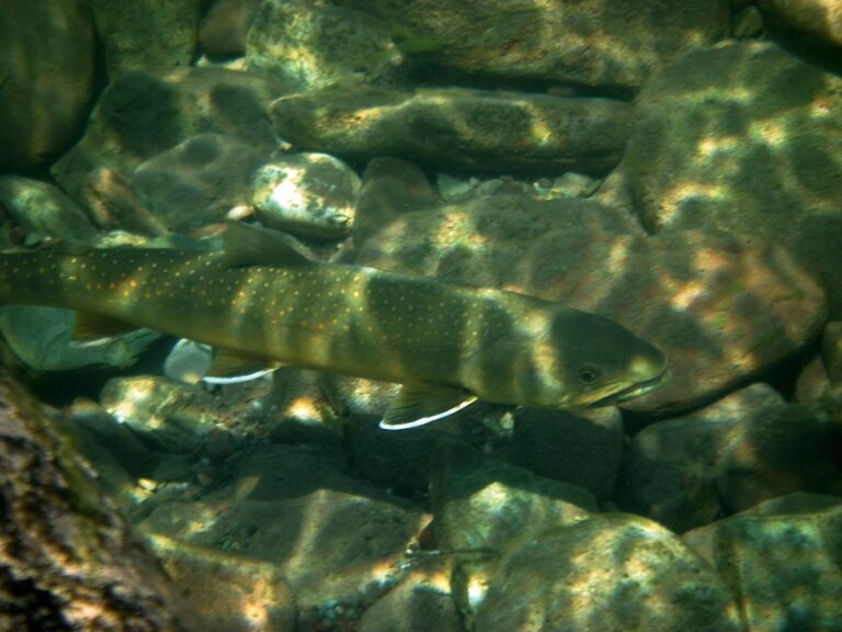
Photo: Forest Service Northern Region, CC BY 2.0

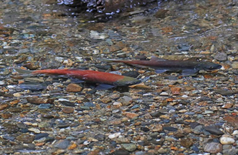
Photo: Judy Gallagher, CC BY 2.0

Photo: Ryndon, CC BY 2.0
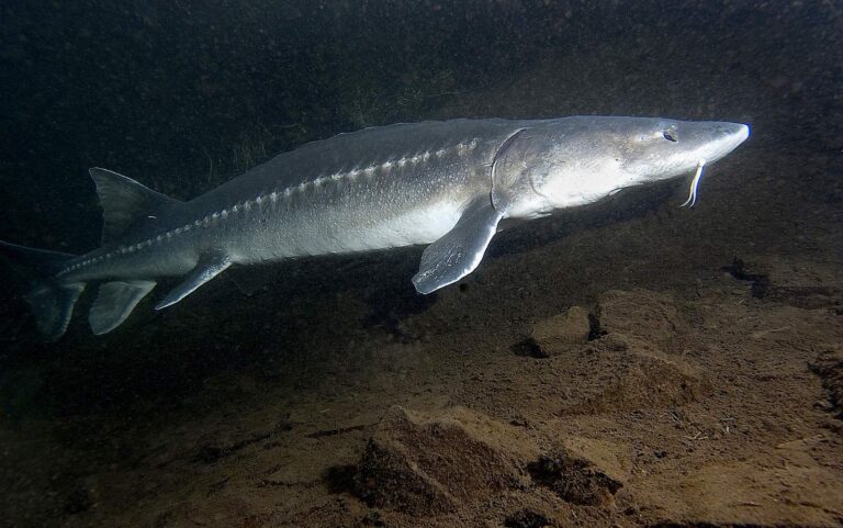
Photo: USFWS Fish and Aquatic Conservation, Public domain
Brief answers on fishing Valley County
How many IDFG, BLM and Forest Service launches serve Valley County?
8 launch sites on the access layers (5 Forest Service and 3 IDFG).
Which lake in Valley County does IDFG list with the most acres?
Cascade Reservoir, at 27,152 acres in the IDFG Fishing Planner.
Which game fish does IDFG name on water near Valley County?
Rainbow trout lead the count of lake pages within 50 miles, followed by brook trout, kokanee and largemouth bass.
Which Valley County stores keep hooks and flies?
6 in all, starting with Tackle Tom's.
How many Idaho guide listings name a Valley County town?
Idaho guide listings name no town inside the county.
Which Idaho town holds the Valley County county offices?
Cascade is the seat.
Does fishing in Valley County need an Idaho license?
The annual license fee written into Idaho Code 36-416 is $28.75 for an Idahoan and $106.25 for a visitor; GoOutdoorsIdaho and vendors add processing.
Which Idaho county guides ring Valley County?
The nearest county pages are Adams County, Boise County and Washington County.
Which IDFG region covers most Valley County water?
93% of the Planner waters sit in the IDFG Southwest Region.
Does Valley County host Idaho bass events or kokanee derbies?
3 events on file from organizer pages, none with a date still ahead.
Does IDFG print special rules for any Valley County water?
The Planner prints special rules for 14 county waters with a page here, starting with Bear Valley Creek; the list above shows the first ones.
Has Valley County water put a fish in the record book?
Lake Trout, 43.25 inches (catch-and-release (length)), from Payette Lake, announced by IDFG in 2026.
Does IDFG stock fish in Valley County?
1,848 IDFG releases listed on Planner pages, 55,997,176 fish; the newest went into Horsethief Reservoir on Oct. 20, 2026.
Can I fish for salmon in Valley County?
The Planner lists steelhead or salmon on Middle Fork Salmon River, South Fork Salmon River and Bear Valley Creek. This page leaves out steelhead and salmon dates because the Commission proclamations were not reachable on the IDFG site in November 2026.
Choose an IDFG lake or river in Valley County
Open a lake for its launches, limits and releases.