Deer River Fishing
A tidal river of the Alabama coast in Mobile County.
 Pick for redfishPiscifun Alloy S inshore spinning reelCheck price at Piscifun
Photo of Mobile Bay: alyssa BLACK, CC BY-SA 2.0
The short version on Deer River for salt water
In Mobile County, Deer River is a tidal river on the Alabama coast. Plan on near 6 miles to Theodore.
There are 7 public ramps serving it. Visitors reach the water at 2 public access sites. Crews built 11 inshore reefs within 12 miles. 8 water level stations from NOAA sit close by.
USGS GNIS domestic names (feature class and primary point), read November 1, 2026; ADCNR coastal layers; Census 2023 places.
Coastal ramps that reach Deer River
- C&S Bait and Tackle boat ramp on Deer Riverramps: 1 (double ramp), business launch, docks: 2, ~60 parking spots, restrooms, 7554 Deer River Road
- Deer River Bait & Tackle boat rampramps: 1, business launch, docks: 2, ~40 parking spots, restrooms, 7560 Deer River Road
- Fowl River Marina on Deer Riverramps: 2, business launch, docks: 3, ~40 parking spots, restrooms, State Highway 193 on the north side of the Fowl River Bridge
- McNally Park on Deer Riverramps: 1, docks: 2, ~15 parking spots, 4380 Park Road
- Memories Fish Camp boat ramp on Deer Riverramps: 1, business launch, docks: 0, ~15 parking spots, 4901 Fowl River Road
- Schwartz Boat Launch on Deer Riverramps: 1, docks: 2, ~25 parking spots, 3810 Schwartz Lane on Rabbit Creek (a tributary to …
- The River Shack Boat Launch on Deer Riverramps: 2, business launch, docks: 3, ~15 parking spots, restrooms, 6152 Marina Drive South (under the Dog River Bridge …
Marinas and bait shops with ramps near Deer River
- C&S Bait and Tackle boat ramp on Deer Riverramps: 1 (double ramp), business launch, docks: 2, ~60 parking spots, restrooms, 7554 Deer River Road
- Deer River Bait & Tackle boat rampramps: 1, business launch, docks: 2, ~40 parking spots, restrooms, 7560 Deer River Road
- Fowl River Marina on Deer Riverramps: 2, business launch, docks: 3, ~40 parking spots, restrooms, State Highway 193 on the north side of the Fowl River Bridge
- Memories Fish Camp boat ramp on Deer Riverramps: 1, business launch, docks: 0, ~15 parking spots, 4901 Fowl River Road
- The River Shack Boat Launch on Deer Riverramps: 2, business launch, docks: 3, ~15 parking spots, restrooms, 6152 Marina Drive South (under the Dog River Bridge …
Beach and bay access by Deer River
- Muddy Creek Wetlands Management AreaWestern Shore
- Wood Park (Helen W. Wood Park)4901 Dauphin Island Parkway, Mobile, Western Shore
More ADCNR ramps close to Deer River
- Dog River Park on Spanish RiverSpanish River, 7 miles north
- Arlington Park on Spanish RiverSpanish River, 9 miles north
- Pier Street Ramp on Mobile BayMobile Bay, 10 miles east
- Delta Port Marina on Heron BayHeron Bay, 11 miles south
- Ted Middleton Jr. Landing on Polecat BayPolecat Bay, 12 miles north
- Tenesaw Public Boat Ramp on Polecat BayPolecat Bay, 12 miles northeast
ADCNR coastal boating access pages and public access site layer (ADCNR GIS), read November 1, 2026; ADCNR WFF public boat ramp list (list), read November 1, 2026.
Walk-out fishing on Deer River
Places to fish on foot near Deer River
- Pier Street Boat Ramp on Mobile Bayfishing pier, salt water, 10 miles
- Weeks Bay Boat Ramp and Pierfishing pier, salt water, 17 miles
- Dauphin Island Public Beach and Fishing Pier (Dauphin Island Main Beach) on Pass Druryfishing pier, salt water, 19 miles
- Magnolia Springs Public Pierfishing pier, salt water, 21 miles
- Fort Morgan Fishing Pier and Boat Ramp on Pass Druryfishing pier, salt water, 21 miles
ADCNR coastal boating access pages and public access site layer (ADCNR GIS), read November 1, 2026.
Reefs an easy run from Deer River
11 inshore reefs lie within 12 miles of Deer River; each row gives year, material and listed depth.
| Reef | Placed | Material | Listed depth | Distance |
|---|---|---|---|---|
| Bender – Austal Reef | 1999 | Concrete pipe and rubble encircling oyster cultch material and 3"x6" limestone aggregate | 7 ft listed depth | 3 miles east |
| Dog River Reef | 7000 tons of 3"x6" limestone aggregate was installed during 2023 | 3 miles northeast | ||
| Dog River Reef | 2023 | 7000 tons of 3"x6" limestone aggregate (2023) | 3 miles northeast | |
| Denton Reef | 1997 | 900 prestressed concrete roof slabs encircling oyster cultch material; 4300 tons of … | 10 ft listed depth | 8 miles south |
| Point Clear Reef | 2016 | 3" x 6" limestone aggregate | 11 ft listed depth | 9 miles southeast |
| Buddy Beiser Reef | 1999 | Concrete pipe and rubble placed around abandon barge and 3" X 6" limestone aggregate | 9 ft listed depth | 10 miles northeast |
| Battles Wharf Reef | 1999 | Concrete pipe and rubble placed inside old pier pilings and 3" X 6" limestone aggregate | 5 ft listed depth | 10 miles east |
| Zundel Landing | 1995 | 300 yds concrete block placed in and around old pier pilings and 3" X 6" limestone … | 4 ft listed depth | 10 miles east |
| P. Grey Cane, Jr. Reef | 1999 | Concrete pipe and rubble placed circular config with oyster half-shells and #57 … | 7 ft listed depth | 10 miles southeast |
| Choctaw Pass Reef | 1999 | Concrete pipe and rubble and 3" X 6" limestone aggregate | 4 ft listed depth | 11 miles northeast |
| Dell Williamson Reef | 1991 | Concrete block and oyster cultch material placed inside old pier pilings and 3"x6" … | 6 ft listed depth | 12 miles northeast |
ADCNR Marine Resources Division public reef master list 2025 (KMZ; reef layer), read November 1, 2026. Coordinates are for information only, not for navigation.
Watching the tide on Deer River
NOAA CO-OPS water level, preliminary reading at retrieval (November 1, 2026); station page for live data.
- Dog River Bridgetide predictions, 3 miles
- East Fowl River, Hwy 193 Bridgetide predictions, 6 miles
- Coast Guard Sector Mobiletide predictions, 9 miles
- Point Clear, Mobile Baytide predictions, 10 miles
Predictions for Deer River are a guide; wind and runoff set the real level.
NOAA CO-OPS water level and tide prediction stations; read November 1, 2026.
Harbors that serve Deer River
- FairhopeBaldwin County, 11 miles
- TheodoreMobile County, 5 miles
- Point ClearBaldwin County, 11 miles
- IrvingtonMobile County, 9 miles
- Alabama PortMobile County, 11 miles
USGS GNIS domestic names (feature class and primary point), read November 1, 2026.
Inshore creel and size rules at Deer River
| Species | Daily limit and size | Waters |
|---|---|---|
| Sheepshead | 8 per person; 12" min. FL | state waters |
| Spotted Seatrout | 6 per person – one fish is allowed to be over; 15" min. TL – 22" max TL | state waters |
| Red Drum (Redfish) | 3 per person; 16" min. – 26" max TL | state waters |
| Cobia (Ling) | 1 per person, not to exceed 2 per vessel; 36" min. FL | state waters |
| Spanish Mackerel | 15 per person; no size limit | state waters |
| Florida Pompano | 3 per person; 12" min. TL | state waters |
| Striped Bass | 2 per person; 16" min TL | state waters |
| Flounder | 5 per person (Closed Season for the month of November); 14" min TL | state waters |
| Tripletail (Blackfish) | 3 per person; 18" min TL | state waters |
| Mullet | Oct. 24-Dec. 31, 25 mullet per person from the shoreline or 25 per boat. No mullet by cast net or snagging in Theodore Industrial Canal, Dog River, Fowl River, and their tributaries.; no siz | state waters |
Redfish, speckled trout and flounder rules for Deer River come first.
Which license applies follows the ADCNR line, printed on the saltwater page.
Saltwater anglers 16 and older carry an Alabama saltwater license ($30.90 resident, $66.80 nonresident for 2026-27), plus the $10 Gulf Reef Fish Endorsement to keep reef fish such as red snapper.
Limits as printed by the ADCNR Marine Resources Division recreational size, creel and possession limits for state waters (MRD limits page), read November 1, 2026.
 For the redfish herePiscifun NautiX saltwater spinning reel14% OFFSale $94.99
Where Deer River ranks along the Alabama coast
By access count, Mobile Bay tops the table at 117.
| Water | Distance | Type | Ramps | Piers and banks | Access sites | Inshore reefs |
|---|---|---|---|---|---|---|
| Deer River | tidal river | 7 | 0 | 2 | 11 | |
| Mobile Bay | 7 miles southeast | bay | 21 | 6 | 96 | 20 |
| Spanish River | 11 miles northeast | tidal river | 2 | 0 | 1 | 6 |
| Apalachee River | 12 miles northeast | tidal river | 0 | 0 | 0 | 7 |
| Polecat Bay | 13 miles north | bay | 2 | 0 | 4 | 6 |
| Blakeley River | 13 miles northeast | tidal river | 1 | 0 | 2 | 7 |
ADCNR ramp, access and reef layers, USGS GNIS; read November 1, 2026.
Inland Alabama options behind Deer River
Neighbouring Alabama lakes to Deer River
- Big Creek Lake22 miles
- Dead Lake26 miles
- Shelby Lakes31 miles
- Citronelle Lake40 miles
Alabama rivers within easy reach of Deer River
- Dog River6 miles
- Fowl River7 miles
- Tensaw River15 miles
- Fish River20 miles
Tackle counters that serve Deer River
- Beachcomber Marina & Dry Dockmarina, Mobile, 3 miles
- Grand Mariner Marinamarina, Mobile, 3 miles
- Mobile Bay Marinamarina, Mobile, 3 miles
- Sundowner Marinamarina, Mobile, 3 miles
- Dog River Marinamarina, Mobile, 3 miles
- Middleton Marine Engine Servicemarina, Mobile, 3 miles
Paid trips on Deer River from our list
- Capt. Lynn's Inshore Adventures Inc.charter, Dauphin Island, (251) 214-5196
- Capt. Mike's Deep Sea Fishingcharter, Dauphin Island, (251) 861-5302
- Captain T's Fishing Charterscharter, Dauphin Island, (251) 454-4107
- DX Guide Fishingcharter, Mobile, (251) 709-4742
- Deupree Outdoor Guide Servicecharter, Mobile
- Doug Houston Outdoors Charterscharter, Dauphin Island, (251) 861-3586
- Fear Knot Fishing Charterscharter, Dauphin Island, (256) 343-5705
- Finatics Fishing Charterscharter, Dauphin Island, (251) 265-3474
Alabama towns within a drive of Deer River
- Theodore6 miles
- Tillmans Corner8 miles
- Mobile10 miles
- Fairhope13 miles
Which county pages list Deer River
- Mobile Countyseat: Mobile
Piscifun rods and reels lined up for Deer River


Piscifun and Amazon links are affiliate links; the site earns a commission on qualifying purchases.
Telling the Deer River fish apart, by photo
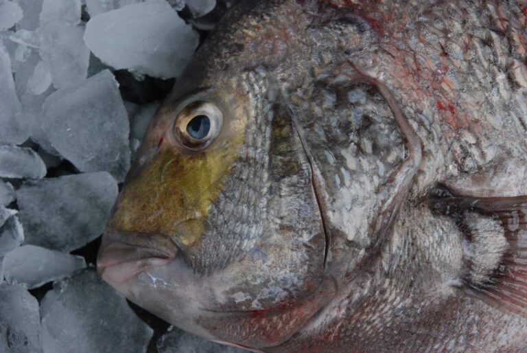
Photo: Louisiana Sea Grant College Program Louisiana State University, CC BY 2.0

Photo: Smithsonian Environmental Research Center, CC BY 2.0


Photo: Smithsonian Environmental Research Center, CC BY 2.0

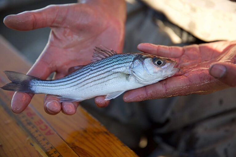
Photo: USFWS Pacific Southwest Region, Public domain
Deer River: answers for an Alabama fishing day
Where is Deer River?
Its named point falls in Mobile County, about 6 miles from Theodore.
Which license covers Deer River?
Saltwater anglers 16 and older carry an Alabama saltwater license ($30.90 resident, $66.80 nonresident for 2026-27), plus the $10 Gulf Reef Fish Endorsement to keep reef fish such as red snapper. The license line is quoted on the saltwater page.
How many ADCNR ramps reach Deer River?
Start at C&S Bait and Tackle boat ramp on Deer River; ADCNR lists 7 public ramps.
How many speckled trout may come home from Deer River?
Red Drum (Redfish): 3 per person; 16" min. – 26" max TL.
Where are tide predictions for Deer River?
Dog River Bridge is the nearest NOAA water level station; its dated reading is in the tide band.
Can I wade Deer River?
Nearest on file: Pier Street Boat Ramp on Mobile Bay, 10 miles.
Which bait counter on our Alabama list serves Deer River?
Closest on our list: Beachcomber Marina & Dry Dock, about 3 miles away,.
Has ADCNR built reefs around Deer River?
11 inshore reefs, starting with Bender – Austal Reef.
Plan a Gulf Coast run to Deer River
Get the Alabama saltwater license squared away online ahead of launch day.