Nisqually Reach Fishing
Washington marine water in Thurston and Pierce counties, inside Marine Area 13.
 Pick for troutPiscifun Carbon X ultralight spinning reel28% OFFSale $57.99
Photo of Carr Inlet: WorldIslandInfo.com, CC BY 2.0
Nisqually Reach at a glance
WDFW counts Nisqually Reach as part of Marine Area 13, off Thurston and Pierce counties. Plan on about 3 miles to reach Anderson Island, the closest town.
Trailers go in at 1 saltwater launch near it. WDFW lists 1 pier or shore site too. WDFW charts 3 named fishing areas inside it. Seasons and limits run to 27 marine rule rows. Tide timing comes from 12 NOAA tide stations.
WDFW recreational marine area layer (WAC 220-311-010) on geodataservices.wdfw.wa.gov, USGS GNIS names, WDFW and State Parks launch layers, WDFW shore fishing layer; retrieved October 31, 2026.
Fish tied to Nisqually Reach in our sources
Fish with a rule row or record on Nisqually Reach.
2026-27 WDFW pamphlet marine area rows and WDFW sport fish records; retrieved October 31, 2026.
 For the trout herePiscifun Carbon XT ultralight spinning reel25% OFFSale $59.99
Named fishing grounds on Nisqually Reach
- Lyle PointBoat Access Only
- McNeil IslandBoat Access Only
- Nisqually HeadBoat Access Only
WDFW Major Fishing Areas layer on geodataservices.wdfw.wa.gov (names and access notes as published); retrieved October 31, 2026.
Ramps boaters use for Nisqually Reach
- Luhr's Landing on Nisqually Reach1 ramp, concrete surface, Discover Pass, WDFW
More WDFW and park launches around Nisqually Reach
- Boston Harbor on Budd InletBudd Inlet, 8 miles west
- Jarrell Cove, south boat launch on Case InletCase Inlet, 12 miles northwest
- Jarrell Cove, north boat launch on Case InletCase Inlet, 12 miles northwest
- Oakland Bay boat launchn/a surface, Discover Pass, 16 miles northwest
- Sherwood Creek boat launch on Case InletCase Inlet, 17 miles north
- North Bay boat launchn/a surface, Discover Pass, 18 miles north
WDFW Water Access Sites and Shore Fishing Sites layers (geodataservices.wdfw.wa.gov) and the Washington State Parks boat launch layer, retrieved October 31, 2026. Parking at WDFW and State Parks launches needs a Discover Pass.
Piers that reach Nisqually Reach
- Luhr's Beach Dock on Nisqually Reachfishing pier, Marine Area 13
Piers and shore sites by Nisqually Reach
- Clyde Davidson Pier (Steilacoom)fishing pier, Marine Area 13, 7 miles
- Fox Island Fishing Pier on Carr Inletfishing pier, Marine Area 13, 9 miles
- Point Defiance Marina Boathouse on Commencement Bayfishing pier, Marine Area 11, 16 miles
- Les Davis Pier on Commencement Bayfishing pier, Marine Area 11, 16 miles
- Old Town Dock on Commencement Bayfishing pier, Marine Area 11, 16 miles
WDFW piers and shore fishing layers, retrieved October 31, 2026.
Harbors and bays inside Nisqually Reach
- Amsterdam Baybay Pierce County
- Baird Covecove Thurston County
- Big Sloughslough Thurston County
- Butterball Covecove Thurston County
- Carlson Baybay Pierce County
- De Wolf Bightother named water Thurston County
- Dogfish Bightother named water Thurston County
- Drayton Passagepassage/strait Pierce County
- East Oro Baybay Pierce County
- Hogum Baybay Thurston County
- Leschi Sloughslough Thurston County
- Mill Bightother named water Thurston County
- Nisqually Flatsother named water Thurston County
- Oro Baybay Pierce County
- Poncin Covecove Thurston County
- Taylor Baybay Pierce County
- Thompson Covecove Pierce County
USGS GNIS names inside the WDFW marine area polygon; retrieved October 31, 2026.
Tide stations for Nisqually Reach
NOAA CO-OPS water level, preliminary reading at retrieval (October 31, 2026); station page for live data.
- Devils Head, Drayton Passagetide predictions, 2 miles
- Sandy Point Anderson Island, Puget Soundtide predictions, 3 miles
- Dupont Wharf, Nisqually Reachtide predictions, 4 miles
- Yoman Point, Anderson Island, Balch Passagetide predictions, 4 miles
- Henderson Inlettide predictions, 5 miles
- Longbranch, Filucy Baytide predictions, 5 miles
Big tidal exchanges move fish and boats on Nisqually Reach; slack water is the easy window for jigging bottomfish.
NOAA CO-OPS water level and tide prediction stations inside or beside the marine area; retrieved October 31, 2026.
Marinas charted near Nisqually Reach
- Oro Bay Marinamarina 253/884-5675
- Tolmie State Parkmarina 360/902-8500
- Longbranch Dockmarina
Older reef records near Nisqually Reach
- Toliva Shoalboat
- Itsami Ledgeboat
NOAA Environmental Sensitivity Index atlas records (2003 to 2006); facility and reef details reflect the source year, not today. Retrieved october 31, 2026.
Keeping salmon and lingcod from Nisqually Reach
| Species and location | Daily limit and size | Season |
|---|---|---|
| Trout | Catch-and-release. | Year-round |
| Steelhead | Daily limit 2 hatchery steelhead. | Year-round |
| Sturgeon | Catch-and-release. | Year-round |
| Mackerel | No min. size. No daily limit. | Year-round |
| Herring, Anchovy, Sardine, Sand Lance, and Smelt | No min. size. Daily limit 10 lbs., all species combined. All smelt caught must be kept and count toward the daily limit except Closed to eulachon (Columbia River smelt). For smelt: Jig gear may be used 7 days a week. Dip | Year-round |
| Pacific Halibut | CLOSED to fishing for, retaining, or possessing. | CLOSED |
| Other Food Fish | No min. size. Daily limit 2 of each species. See definition. | Year-round |
| All Other Fish | CLOSED to fishing for, retaining, or possessing. | CLOSED |
| Salmon (Entire Area (see exceptions for Toliva Shoal, Northern/Southern Budd Inlet, and Fox Island Public Fish | Chinook – min. size 20”. Other salmon species – no min. size. Daily limit 2. Release chum, wild coho, and wild Chinook. Anglers may fish with two poles with Two-Pole Endorsement. | July 1-Sept. 30 |
| Salmon (Entire Area (see exceptions for Toliva Shoal, Northern/Southern Budd Inlet, and Fox Island Public Fish | Chinook – min. size 22”. Other salmon species – no min. size. Daily limit 2. Release chum, wild coho, and wild Chinook. Anglers may fish with two poles with Two-Pole Endorsement. | Oct. 1-June 30 |
| Salmon (Toliva Shoal) | CLOSED. | June 16-Apr. 30 |
| Salmon (Toliva Shoal) | Chinook – min. size 22”. Other salmon species – no min. size. Daily limit 2. Release chum, wild coho, and wild Chinook. Anglers may fish with two poles with Two-Pole Endorsement. | May 1-June 15 |
| Salmon (Northern Budd Inlet) | Chinook – min. size 20”. Other salmon species – no min. size. Daily limit 2. Release chum, wild coho, and wild Chinook. Night closure and anti-snagging rule. Anglers may fish with two poles with Two-Pole Endorsement. | July 1-Sept. 30 |
| Salmon (Northern Budd Inlet) | Chinook – min. size 22”. Other salmon species – no min. size. Daily limit 2. Release chum, wild coho, and wild Chinook. Night closure and anti-snagging rule. Anglers may fish with two poles with Two-Pole Endorsement. | Oct. 1-Oct. 31 |
| Salmon (Northern Budd Inlet) | Chinook – min. size 22”. Other salmon species – no min. size. Daily limit 2. Release chum, wild coho, and wild Chinook. Anglers may fish with two poles with Two-Pole Endorsement. | Nov. 1-June 30 |
| Salmon (Southern Budd Inlet) | CLOSED. | July 1-Oct. 31 |
| Salmon (Southern Budd Inlet) | Chinook – min. size 22”. Other salmon species – no min. size. Daily limit 2. Release chum, wild coho, and wild Chinook. Anglers may fish with two poles with Two-Pole Endorsement. | Nov. 1-June 30 |
| Salmon (Fox Island Public Fishing Pier) | Chinook – min. size 20”. Other salmon species – no min. size. Daily limit 2 including no more than 1 Chinook. Release chum. | July 1-Sept. 30 |
| Salmon (Fox Island Public Fishing Pier) | Chinook – min. size 22”. Other salmon species – no min. size. Daily limit 2 including no more than 1 Chinook. Release chum. | Oct. 1-June 30 |
| Bottomfish | Year-round season. Daily limit is a total of 15 bottomfish (See definition) subject to individual limits and seasons shown below. Fishing for bottomfish prohibited in waters deeper than 120’. Descending device required o | see the pamphlet |
| Lingcod | Hook and line season. Min. size 26”. Max. size 36”. Daily limit 1. | May 1-June 15 |
| Lingcod | Spearfishing season. Max. size 36”. Daily limit 1. | May 21-June 15 |
| Surfperch | No min. size. Daily limit 10. Except shiner perch daily limit 15: not included in bottomfish limit. | Year-round |
| Rockfish | CLOSED to fishing for, retaining, or possessing. | CLOSED |
Marine Area 13 carries 27 rows; the rest are in the pamphlet.
Anglers 16 and older fishing marine water carry a Saltwater license ($40.71 resident, $81.70 nonresident for 2026-27) or a Combination license, plus a catch record card for salmon, sturgeon, steelhead or halibut.
Limits and seasons as printed in the 2026-2027 Washington Sport Fishing Rules (WDFW pamphlet, in effect July 1, 2026 to June 30, 2027), PDF page 132 (pamphlet PDF; eRegulations marine area page), read October 31, 2026.
Nisqually Reach beside other Washington marine water
| Water | Distance | Marine area | Launches | Piers and shore sites | Tide stations |
|---|---|---|---|---|---|
| Nisqually Reach | Marine Area 13 | 1 | 1 | 12 | |
| South Puget Sound (Marine Area 13) | 8 miles | Marine Area 13 | 9 | 4 | 21 |
| Carr Inlet | 8 miles | Marine Area 13 | 1 | 1 | 16 |
| Budd Inlet | 9 miles | Marine Area 13 | 1 | 0 | 7 |
| Case Inlet | 11 miles | Marine Area 13 | 5 | 0 | 12 |
| Commencement Bay | 17 miles | Marine Area 11 | 0 | 5 | 7 |
WDFW marine areas and access layers, NOAA stations; retrieved October 31, 2026.
Next to Nisqually Reach
Next marine pages from Nisqually Reach
- South Puget Sound (Marine Area 13)8 miles
- Carr Inlet8 miles
- Budd Inlet9 miles
- Case Inlet11 miles
- Commencement Bay17 miles
Inland options close to Nisqually Reach
- Florence Lake3 miles
- Bay Lake7 miles
- Long's Pond7 miles
- Lake Louise8 miles
- Deschutes River14 miles
- Rocky Creek17 miles
- Puyallup River21 miles
- Skokomish River23 miles
Tackle counters within a quick drive of Nisqually Reach
- Cabela's Laceysporting goods store, Lacey, 5 miles
- Dick's Sporting Goods Olympiasporting goods store, Olympia, 11 miles
- Bass Pro Shops Tacomasporting goods store, Tacoma, 13 miles
- Dick's Sporting Goods Tacomasporting goods store, Tacoma, 14 miles
- Dick's Sporting Goods Puyallupsporting goods store, Puyallup, 21 miles
- Sportsman's Warehouse Puyallupsporting goods store, Puyallup, 21 miles
Who runs guided trips on Nisqually Reach
- Mount Rainier Flyreel Workscharter, Buckley, (360) 829-3691
- The Fly Fishercharter, Lacey, (360) 491-0181
- Wild Rivers Guided Fishing Tripscharter, Orting, (253) 222-6886
- D & J Guided Sport Fishingfishing guide, Olympia, (206) 914-9137
Washington towns with beds close by Nisqually Reach
- Anderson Island3 miles
- DuPont5 miles
- Longbranch6 miles
- Tanglewilde6 miles
The counties around Nisqually Reach
- Thurston Countyseat: Olympia
- Pierce Countyseat: Tacoma
A Piscifun spinning setup worth packing for Nisqually Reach


Piscifun and Amazon links are affiliate links; the site earns a commission on qualifying purchases.
How to tell one Nisqually Reach fish from another, by photo

Photo: Olympic National Park, Public domain

Photo: Oregon Department of Fish & Wildlife, Public domain

Photo: Ed Bierman, CC BY 2.0
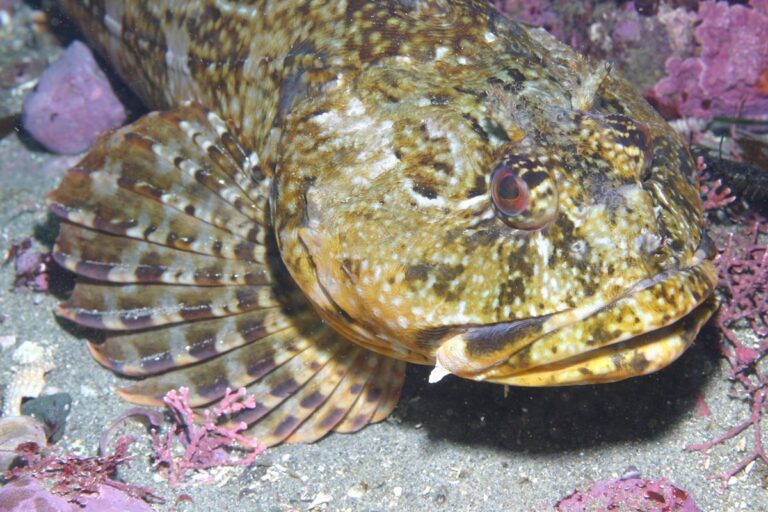
Photo: Steve Lonhart (SIMoN / MBNMS), Public domain

Quick replies about fishing Nisqually Reach
Which rule area covers Nisqually Reach?
It falls under Marine Area 13.
How many salmon may I keep from Nisqually Reach?
Chinook – min. size 20”. Other salmon species – no min. size. Daily limit 2. Release chum, wild coho, and wild Chinook. Anglers may fish with two poles with Two (July 1-Sept. 30) under Marine Area 13; emergency rules override.
When is lingcod season on Nisqually Reach?
Pamphlet lingcod row: Hook and line season. Min. size 26”. Max. size 36”. Daily limit 1. (May 1-June 15).
Where do salmon boats put in for Nisqually Reach?
1 launch appear in the access layers, including Luhr's Landing on Nisqually Reach.
Can I fish Nisqually Reach from shore?
1 pier or shore site on the WDFW layer, Luhr's Beach Dock on Nisqually Reach among them.
Does Nisqually Reach take a Saltwater or Combination license?
Anglers 16 and older fishing marine water carry a Saltwater license ($40.71 resident, $81.70 nonresident for 2026-27) or a Combination license, plus a catch record card for salmon, sturgeon, steelhead or halibut.
How big are the tides on Nisqually Reach?
Devils Head, Drayton Passage is the closest prediction station in our list.
Which store do Nisqually Reach regulars use for herring and leader?
Cabela's Lacey, about 5 miles away leads our list here.
Where do anglers fish on Nisqually Reach?
The WDFW layer marks 3 named fishing areas, Lyle Point, McNeil Island and Nisqually Head among them.
Book a morning on Nisqually Reach
Marine seasons, limits and fees live on one page.