Tacoma-Vashon Island Fishing, Marine Area 11
WDFW Marine Area 11 on the Washington coast and Salish Sea, touching Pierce, King and Kitsap counties.
 Pick for troutPiscifun Carbon X ultralight spinning reel28% OFFSale $57.99
Photo of Commencement Bay: Jameson Fink, CC BY 2.0
Tacoma-Vashon Island in figures
Under WAC 220-311-010, Marine Area 11 (Tacoma-Vashon Island) covers marine water off Pierce, King and Kitsap counties. From the mapped point, Des Moines lies about 3 miles away. Boats run out of Tacoma.
Anglers without a boat have 8 piers and shore sites. The WDFW fishing area layer marks 6 named fishing areas. Read its 28 marine rule rows before keeping fish. NOAA tide predictions cover 6 NOAA tide stations.
WDFW recreational marine area layer (WAC 220-311-010) on geodataservices.wdfw.wa.gov, USGS GNIS names, WDFW and State Parks launch layers, WDFW shore fishing layer; retrieved October 31, 2026.
Mapping the borders of Tacoma-Vashon Island
- Defined(11) … the Tacoma Narrows Bridge.
- Defined(10): … a line projected true east-west through the northern tip of Vashon Island.
Navigation marks on the edges of Tacoma-Vashon Island
- Tacoma Narrows BridgeBridge
- Pt. VashonPoint (Approx. 47.5110° N)
WAC 220-311-010 boundary text as published in the WDFW marine area layer; NOAA light list positions; retrieved October 31, 2026.
Fish anglers target on Tacoma-Vashon Island
Fish the rules and records tie to Tacoma-Vashon Island; many more species live there.
2026-27 WDFW pamphlet marine area rows and WDFW sport fish records; retrieved October 31, 2026.
 For the trout herePiscifun Carbon XT ultralight spinning reel25% OFFSale $59.99
Major fishing areas in Tacoma-Vashon Island
- Browns PointShoreline Access Available
- Browns to Dash PointBoat Access Only
- Dash PointShoreline Access Available
- Des MoinesBoat Access Only
- Point DefianceBoat Access Only
- South Maury IslandBoat Access Only
WDFW Major Fishing Areas layer on geodataservices.wdfw.wa.gov (names and access notes as published); retrieved October 31, 2026.
Ramps that open onto Tacoma-Vashon Island
No ramp on Tacoma-Vashon Island appears in the access layers, so boats run in from launches nearby.
Other ramps near Tacoma-Vashon Island
- Ross Point boat launch on Sinclair InletSinclair Inlet, 18 miles northwest
WDFW Water Access Sites and Shore Fishing Sites layers (geodataservices.wdfw.wa.gov) and the Washington State Parks boat launch layer, retrieved October 31, 2026. Parking at WDFW and State Parks launches needs a Discover Pass.
Walk-out fishing on Tacoma-Vashon Island
- Des Moines Marina Pierfishing pier, Marine Area 11
- Redondo Pierfishing pier, Marine Area 11
- Dash Point Park Pier on Commencement Bayfishing pier, Marine Area 11
- Tramp Harbor Pier on Colvos Passagefishing pier, Marine Area 11
- Point Defiance Marina Boathouse on Commencement Bayfishing pier, Marine Area 11
- Les Davis Pier on Commencement Bayfishing pier, Marine Area 11
- Old Town Dock on Commencement Bayfishing pier, Marine Area 11
- Dockton Park Pier on Colvos Passagefishing pier, Marine Area 11
Shore access within reach of Tacoma-Vashon Island
- Blake Island State Park Pierfishing pier, Marine Area 10, 13 miles
- Spokane St. Bridge on Elliott Bayfishing pier, Marine Area 10, 14 miles
- Fox Island Fishing Pier on Carr Inletfishing pier, Marine Area 13, 14 miles
- Seacrest Park Pier on Elliott Bayfishing pier, Marine Area 10, 15 miles
- Manchester Boat Dock on Sinclair Inletfishing pier, Marine Area 10, 15 miles
WDFW piers and shore fishing layers, retrieved October 31, 2026.
Named coves around Tacoma-Vashon Island
- Blair Waterwayother named water Pierce County
- Christensen Covecove King County
- City Waterwayother named water Pierce County
- Dalco Passagepassage/strait Pierce County
- Driftwood Covecove Kitsap County
- Dumas Baybay King County
- East Passagepassage/strait King County
- Fern Covecove King County
- Gig Harborharbor Pierce County
- Hylebos Waterwayother named water Pierce County
- Lower Turning Basinother named water Pierce County
- Middle Waterwayother named water Pierce County
- Milwaukee Waterwayother named water Pierce County
- Olalla Baybay Kitsap County
- Paradise Covecove King County
- Poverty Baybay King County
- Puyallup Waterwayother named water Pierce County
- Quartermaster Harborharbor King County
- Rabbs Lagoonlagoon King County
- Saint Paul Waterwayother named water Pierce County
- Sitcum Waterwayother named water Pierce County
- The Narrowother named water Pierce County
- The Narrowspassage/strait Pierce County
- Thea Foss Waterwayother named water Pierce County
- Tramp Harborharbor King County
USGS GNIS names inside the WDFW marine area polygon; retrieved October 31, 2026.
Tides and water level at Tacoma-Vashon Island
NOAA CO-OPS water level, preliminary reading at retrieval (October 31, 2026); station page for live data.
- Des Moines, East Passagetide predictions, 3 miles
- Burton, Quartermaster Hbr. (Inside), Vashon I.tide predictions, 5 miles
- Gig Harbortide predictions, 10 miles
- Tahlequah, Neil Pt., Dalco Passage, Vashon I.tide predictions, 7 miles
- Tacoma, Commencement Bay, Sitcum Waterwaytide predictions, 8 miles
- Tacoma Narrows Bridgetide predictions, 11 miles
Tide height on Tacoma-Vashon Island decides which launches and beaches work; check before you go.
NOAA CO-OPS water level and tide prediction stations inside or beside the marine area; retrieved October 31, 2026.
Marinas around Tacoma-Vashon Island (NOAA ESI record)
- Totem Marina Moorage Assoc.marina 253/272-4404
- Ole & Charlie's Marinamarina 253/272-1173
- Chinook Landing Marinamarina 253/845-9225
- Arabella's Landing Marinamarina 253/851-1793
- City Of Des Moines Marinamarina 206/878-4995
- Point Defiance Boathousemarina 253/305-1077
- Quartermaster Marinamarina 206/463-3624
- Saltwater State Parkmarina 360/902-8500
- Des Moines Yacht Clubmarina 206/878-4995
- Tyee Marinamarina 253/838-2280
- Dockton Parkmarina 206/296-8687
Structure placed near Tacoma-Vashon Island
- Point Heyerboat
NOAA Environmental Sensitivity Index atlas records (2003 to 2006); facility and reef details reflect the source year, not today. Retrieved october 31, 2026.
Washington saltwater rules on Tacoma-Vashon Island
| Species and location | Daily limit and size | Season |
|---|---|---|
| Trout | Catch-and-release. | Year-round |
| Steelhead | Daily limit 2 hatchery steelhead. | Year-round |
| Sturgeon | Catch-and-release. | Year-round |
| Mackerel | No min. size. No daily limit. | Year-round |
| Herring, Anchovy, Sardine, Sand Lance, and Smelt | No min. size. Daily limit 10 lbs., all species combined. All smelt caught must be kept and count toward the daily limit except Closed to eulachon (Columbia River smelt). For smelt: Jig gear may be used 7 days a week. Dip | Year-round |
| Pacific Halibut | CLOSED to fishing for, retaining, or possessing. | CLOSED |
| Other Food Fish | No min. size. Daily limit 2 of each species. See definition. | Year-round |
| All Other Fish | CLOSED to fishing for, retaining, or possessing. | CLOSED |
| Salmon (Entire Area (see exception for Commencement Bay and piers below)) | Chinook – min. size 22”. Other salmon species – no min. size. Daily limit 2 including no more than 1 Chinook. Release chum and wild Chinook. | June 1-June 30 |
| Salmon (Entire Area (see exception for Commencement Bay and piers below)) | CLOSED. | July 1-July 22 |
| Salmon (Entire Area (see exception for Commencement Bay and piers below)) | Chinook – min. size 22”. Other salmon species – no min. size. Daily limit 2 including no more than 1 Chinook. Release chum and wild Chinook. | July 23-Sept. 30 |
| Salmon (Entire Area (see exception for Commencement Bay and piers below)) | No min. size. Daily limit 2. Release Chinook. | Oct. 1-Nov. 15 |
| Salmon (Entire Area (see exception for Commencement Bay and piers below)) | CLOSED. | Nov. 16-Mar. 30 |
| Salmon (Entire Area (see exception for Commencement Bay and piers below)) | Open Wed.-Sat. only. Closed Sun-Tues. Chinook – min. size 22”. Other salmon species – no min. size. Daily limit 2 including no more than 1 Chinook. Release chum and wild Chinook. | Mar. 31-Apr. 30 |
| Salmon (Commencement Bay) | CLOSED. | June 1-July 31 |
| Salmon (Commencement Bay) | Chinook – min. size 22”. Other salmon species – no min. size. Daily limit 2. Release chum and wild Chinook. Chinook retention may close earlier if quota is attained. | Aug. 1-Sept. 30 |
| Salmon (Commencement Bay) | No min. size. Daily limit 2. Release Chinook. | Oct. 1-Oct. 31 |
| Salmon (Commencement Bay) | CLOSED. | Nov. 1-Apr. 30 |
| Salmon (Des Moines Pier, Les Davis Pier, Point Defiance Boathouse Dock, and Redondo Pier) | Chinook – min. size 22”. Other salmon species – no min. size. Daily limit 2 including no more than 1 Chinook. Release chum. | May. 1-Sept. 30 |
| Salmon (Des Moines Pier, Les Davis Pier, Point Defiance Boathouse Dock, and Redondo Pier) | Chinook – min. size 22”. Other salmon species – no min. size. Daily limit 2 including no more than 1 Chinook. | Oct. 1-Apr. 30 |
| Bottomfish | Year-round season. Daily limit is a total of 15 bottomfish (See definition) subject to individual limits and seasons shown below. Fishing for bottomfish prohibited in waters deeper than 120’. Descending device required o | see the pamphlet |
| Lingcod | Hook and line season. Min. size 26”. Max. size 36”. Daily limit 1. | May 1-June 15 |
| Lingcod | Spearfishing season. Max. size 36”. Daily limit 1. | May 21-June 15 |
| Surfperch | No min. size. Daily limit 10. Except shiner perch daily limit 15: not included in bottomfish limit. | Year-round |
Only 24 of the 28 rows for Marine Area 11 fit.
Anglers 16 and older fishing marine water carry a Saltwater license ($40.71 resident, $81.70 nonresident for 2026-27) or a Combination license, plus a catch record card for salmon, sturgeon, steelhead or halibut.
Limits and seasons as printed in the 2026-2027 Washington Sport Fishing Rules (WDFW pamphlet, in effect July 1, 2026 to June 30, 2027), PDF page 128 (pamphlet PDF; eRegulations marine area page), read October 31, 2026.
Where boats tie up for Tacoma-Vashon Island
- TacomaPierce County
USGS GNIS populated places and harbors named by WDFW for the area; retrieved October 31, 2026.
Tacoma-Vashon Island against the closest bays and areas
| Water | Distance | Marine area | Launches | Piers and shore sites | Tide stations |
|---|---|---|---|---|---|
| Tacoma-Vashon Island | Marine Area 11 | 0 | 8 | 6 | |
| Commencement Bay | 7 miles | Marine Area 11 | 0 | 5 | 7 |
| Colvos Passage | 8 miles | Marine Area 11 | 0 | 2 | 7 |
| South Puget Sound (Marine Area 13) | 16 miles | Marine Area 13 | 9 | 4 | 21 |
| Elliott Bay | 16 miles | Marine Area 10 | 0 | 5 | 10 |
| Carr Inlet | 17 miles | Marine Area 13 | 1 | 1 | 16 |
WDFW marine areas and access layers, NOAA stations; retrieved October 31, 2026.
Around the Tacoma-Vashon Island area
More bays and areas past Tacoma-Vashon Island
- Commencement Bay7 miles
- Colvos Passage8 miles
- South Puget Sound (Marine Area 13)16 miles
- Elliott Bay16 miles
- Carr Inlet17 miles
Where else to fish around Tacoma-Vashon Island
- Star Lake4 miles
- Steele Lake5 miles
- Lake Fenwick5 miles
- Lake Dolloff5 miles
- Duwamish River9 miles
- White River (Pierce County)12 miles
- Puyallup River12 miles
- Rocky Creek19 miles
Where to buy worms, eggs and jigs for Tacoma-Vashon Island
- Sportsman's Warehouse Federal Waysporting goods store, Federal Way, 6 miles
- Dick's Sporting Goods Tukwilasporting goods store, Tukwila, 7 miles
- Dick's Sporting Goods Tacomasporting goods store, Tacoma, 12 miles
- Bass Pro Shops Tacomasporting goods store, Tacoma, 14 miles
- Sportsman's Warehouse Puyallupsporting goods store, Puyallup, 15 miles
- Dick's Sporting Goods Puyallupsporting goods store, Puyallup, 15 miles
Guide boats working Tacoma-Vashon Island
- Adventure Charterscharter, Seattle, (206) 789-8245
- Digital Anglerscharter, Redmond, (206) 819-7010
- Emerald Water Anglerscharter, Seattle, (206) 708-7250
- Fish Finders Private Charterscharter, Seattle, (206) 632-2611
- Mount Rainier Flyreel Workscharter, Buckley, (360) 829-3691
- Screaminreels Guide Servicecharter, Duvall, (206) 849-2574
- Tight Lines Sports Fishingcharter, Des Moines, (206) 715-0879
- Wild Rivers Guided Fishing Tripscharter, Orting, (253) 222-6886
Washington towns handy to Tacoma-Vashon Island
- Des Moines3 miles
- Normandy Park4 miles
- Federal Way5 miles
- Vashon5 miles
Counties that hold part of Tacoma-Vashon Island
- Pierce Countyseat: Tacoma
- King Countyseat: Seattle
- Kitsap Countyseat: Port Orchard
What Piscifun sells for a morning at Tacoma-Vashon Island


Piscifun and Amazon links are affiliate links; the site earns a commission on qualifying purchases.
Fish worth recognising before a day at Tacoma-Vashon Island

Photo: Olympic National Park, Public domain

Photo: Oregon Department of Fish & Wildlife, CC BY-SA 2.0

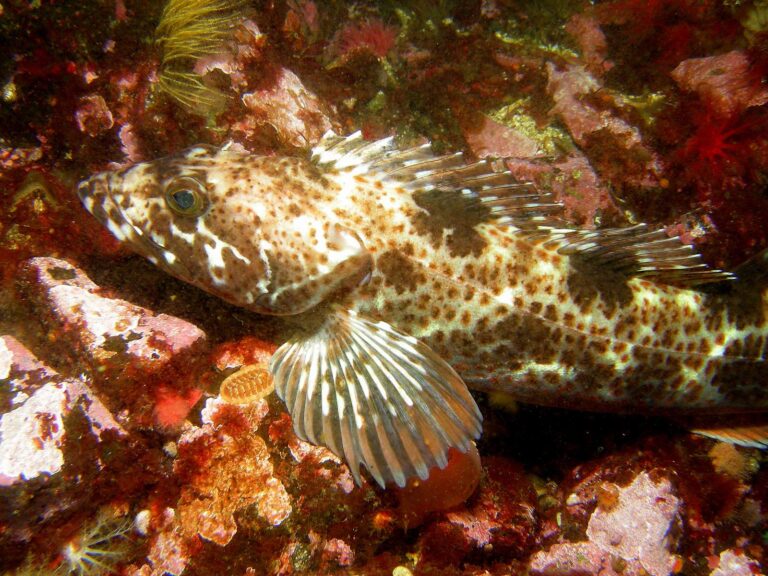
Photo: Ed Bierman, CC BY 2.0
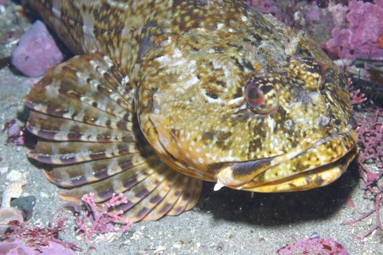
Photo: Steve Lonhart (SIMoN / MBNMS), Public domain

Tacoma-Vashon Island, asked and answered for Evergreen State anglers
Which marine area is Tacoma-Vashon Island?
Use the rows for Marine Area 11.
What is the salmon limit on Tacoma-Vashon Island?
Pamphlet salmon row, Marine Area 11: Chinook – min. size 22”. Other salmon species – no min. size. Daily limit 2 including no more than 1 Chinook. Release chum and wild Chinook., June 1-June 30.
Is bottomfish open on Tacoma-Vashon Island?
WDFW prints Hook and line season. Min. size 26”. Max. size 36”. Daily limit 1. for lingcod, May 1-June 15.
Which listed saltwater ramp sits closest to Tacoma-Vashon Island?
Run in from Ross Point boat launch on Sinclair Inlet, about 18 miles away.
Is there bank access on Tacoma-Vashon Island?
WDFW maps 8 piers and shore sites; Des Moines Marina Pier is one.
Can out-of-state visitors fish Tacoma-Vashon Island?
Anglers 16 and older fishing marine water carry a Saltwater license ($40.71 resident, $81.70 nonresident for 2026-27) or a Combination license, plus a catch record card for salmon, sturgeon, steelhead or halibut.
Where can I check the tides for Tacoma-Vashon Island?
The tide band lists Des Moines, East Passage and others.
Which tackle shop serves Tacoma-Vashon Island?
Sportsman's Warehouse Federal Way is the nearest shop we list, about 6 miles away.
Where are the fishing grounds on Tacoma-Vashon Island?
Start with Browns Point, Browns to Dash Point and Dash Point, one of 6 named fishing areas.
Rig the downriggers for Tacoma-Vashon Island
Every Washington saltwater fee and season sits one click away.