Fishing in San Juan County, Utah
County seat: Monticello. Census 2020 residents: 14,518.
- 6lake pages
- 9launches
 Pick for bluegillPiscifun Carbon X ultralight spinning reel28% OFFSale $57.99
Photo of Panguitch Lake: Ken Lund, CC BY-SA 2.0
San Juan County: the Utah short version
San Juan County keeps its county offices in Monticello, and the 2020 Census found 14,518 people across the county. Census Gazetteer figures give it 7,824 square miles of land and 110 square miles of water. The county has 6 Utah lakes and reservoirs with pages, and the largest is Recapture Reservoir.
County totals: 9 launches from the launch layers and 9 shore or pier points from DWR. DWR's 2026 stocking table shows 29 stocking rows in the county, 243,006 fish across 11 waters.
U.S. Census Bureau, 2020 Census counts (TIGERweb) and the 2023 Gazetteer, read November 11, 2026. UGRC Boat Ramps layer (ArcGIS service) and the DWR Fish Utah access list, read November 11, 2026.
A Beehive State water map of San Juan County
UGRC Boat Ramps layer (ArcGIS service) and the DWR Fish Utah access list, read November 11, 2026. Lake pins are the DWR map point for each water.
Reservoirs and ponds in San Juan County, Utah
| Lake | Size | Launches | Status | DWR lists |
|---|---|---|---|---|
| Recapture Reservoir | about 221 acres of mapped outline | 0 | reservoir | bullhead, bluegill, green sunfish, largemouth bass, northern pike, crappie Black |
| Lloyds Lake | 100 acres | 2 | natural lake | rainbow trout |
| Kens Lake | about 52 acres of mapped outline | 1 | natural lake | largemouth bass, rainbow trout |
| Foy Lake | 5 acres | 0 | natural lake | brook trout, rainbow trout |
| Monticello Lake | 3 acres | 0 | natural lake | rainbow trout, tiger trout |
| Blanding Reservoir No. 4 | no DWR figure | 1 | reservoir | rainbow trout, tiger trout |
Size as the DWR Fish Utah page for this water prints it (DWR), read November 11, 2026. Waters with no DWR acreage print their mapped outline instead. Utah DWR Fish Utah planner (dwrapps.utah.gov), read November 11, 2026.
 For the bluegill herePiscifun Carbon XT ultralight spinning reel25% OFFSale $59.99
Fish DWR rates most often around San Juan County
Lake lists inside 40 miles of Monticello name rainbow trout as likely or possible most often.
DWR Fish Utah species lists (likely or possible), counted per lake page within 40 miles; DWR’s ratings, not a catch survey. Utah DWR Fish Utah planner (dwrapps.utah.gov), read November 11, 2026.
Named Utah ponds of San Juan County still missing a write-up
DWR and the UGRC lakes layer name 16 more waters in San Juan County without enough published facts for a page of their own.
| Water | Size | Listed by |
|---|---|---|
| Blanding City Reservoirs | about 76 acres of mapped outline | UGRC lakes layer |
| TexasGulf Potash Pond Three A | about 51 acres of mapped outline | UGRC lakes layer |
| Dugout Reservoir | about 31 acres of mapped outline | UGRC lakes layer |
| TexasGulf Potash Pond Three B | about 30 acres of mapped outline | UGRC lakes layer |
| TexasGulf Potash Pond Two G | about 24 acres of mapped outline | UGRC lakes layer |
| Rattlesnake Ranch Number Two Reservoir | about 21 acres of mapped outline | UGRC lakes layer |
| Rio Algom Lower Tailings Pond | about 20 acres of mapped outline | UGRC lakes layer |
| Keller Reservoir | about 18 acres of mapped outline | UGRC lakes layer |
| Rio Algom Upper Tailings Pond | about 18 acres of mapped outline | UGRC lakes layer |
| Snyder Reservoir Number Two | about 18 acres of mapped outline | UGRC lakes layer |
| Wilcox Reservoir | about 17 acres of mapped outline | UGRC lakes layer |
| TexasGulf Potash Pond Two N | about 17 acres of mapped outline | UGRC lakes layer |
| Duck Lake | about 15 acres of mapped outline | UGRC lakes layer |
| Blanding City Number Three Reservoir | about 12 acres of mapped outline | UGRC lakes layer |
| Lower Bankhead Reservoir | about 12 acres of mapped outline | UGRC lakes layer |
| Gordon Reservoir | about 11 acres of mapped outline | UGRC lakes layer |
Outline area from the UGRC Utah Lakes NHD layer (ArcGIS service; mapped polygon area, not a DWR surface-acre figure), read November 11, 2026. Listed waters are not claimed to hold fish. Utah DWR Fish Utah planner (dwrapps.utah.gov), read November 11, 2026.
Rivers and creeks running through San Juan County
Live river gauges in San Juan County
| USGS gauge | Latest reading | Time (ET) |
|---|---|---|
| Mill Creek At Sheley Tunnel, Near Moab, Ut | 11 cfs, 3.62 ft gage height | Nov 13 5:15 pm |
| Mill Creek Below Sheley Tunnel, Near Moab, Ut | 2 cfs, 1.30 ft gage height | Nov 13 5:20 pm |
| Pack Creek At Pack Creek Road Bridge Near Moab, Ut | 0 cfs, 27.76 ft gage height | Nov 13 5:15 pm |
| Mcelmo Creek Near Bluff, Utah | 4.30 ft gage height | Nov 13 4:45 pm |
| South Creek Above Reservoir Near Monticello, Ut | 5.60 ft gage height | Nov 13 5:00 pm |
US Geological Survey provisional data, retrieved Nov 13, 2026 5:32 pm ET. Provisional readings can be revised.
Utah DWR Fish Utah planner (dwrapps.utah.gov), read November 11, 2026. USGS Water Data for the Nation, live through the site, retrieved on page view.
Boat launches inside San Juan County
- Halls Crossing Marina at Lake PowellLake Powell, boat ramp, for any vessel class, administered by the National Park Service in the UGRC layer, cycling, drinking water, electrical hook-us
- Hite Marina at Lake PowellLake Powell, boat ramp, for any vessel class, administered by the National Park Service in the UGRC layer, backpacking, cycling, hand launch
- Hite South Boat Ramp at Lake PowellLake Powell, boat ramp, backpacking, cycling, hand launch
- Boat ramp, parking area, trailhead to shoreline paths at Blanding Reservoir No. 4Blanding Reservoir No. 4, boat ramp, restrooms – accessible, trails/shoreline paths
- Hand launch area at Lloyds LakeLloyds Lake, hand launch
- Mexican Hat Boat Ramp at San Juan RiverSan Juan River, boat ramp, for float craft, administered by the Bureau of Land Management in the UGRC layer
- Primitive boat ramp at Kens LakeKens Lake, boat ramp
- Primitive boat ramp at Lloyds LakeLloyds Lake, boat ramp
- Sand Island Boat Ramp at San Juan RiverSan Juan River, boat ramp, for float craft, administered by the Bureau of Land Management in the UGRC layer
Utah piers and bank access across San Juan County
- Kens Lake campgroundKens Lake, shore access
- Covered pavillion Shore Access at Lloyds LakeLloyds Lake, shore access
- East Boat Ramp Shore Access at Recapture ReservoirRecapture Reservoir, shore access
- Foy Lake Parking area Shore AccessFoy Lake, shore access
- Parking area/restroom Shore Access at Monticello LakeMonticello Lake, shore access
- Restroom/parking area Shore Access at Lloyds LakeLloyds Lake, shore access
- Restroom/parking area Shore Access at Lloyds LakeLloyds Lake, shore access
- Trailhead Shore Access at Foy LakeFoy Lake, shore access
- West Boat Ramp Shore Access at Recapture ReservoirRecapture Reservoir, shore access
UGRC Boat Ramps layer (ArcGIS service) and the DWR Fish Utah access list, read November 11, 2026. Neither layer publishes fees or opening hours.
Utah hatchery fish released in San Juan County
Latest first, the county's 2026 rows keep DWR's abbreviated water names.
| Date | Water as DWR prints it | County | Fish | Species |
|---|---|---|---|---|
| October 13, 2026 | STARVATION RES | San Juan | 10,140 | Rainbow |
| September 22, 2026 | BLANDING RES NO 3 | San Juan | 1,610 | Rainbow |
| September 22, 2026 | LLOYDS L | San Juan | 2,002 | Rainbow |
| September 10, 2026 | DARK CYN L | San Juan | 2,002 | Grayling arctic |
| August 31, 2026 | BLANDING RES NO 4 | San Juan | 2,005 | Rainbow |
| July 27, 2026 | BLANDING RES NO 4 | San Juan | 4,506 | Tiger trout |
| July 27, 2026 | MONTICELLO L | San Juan | 1,000 | Tiger trout |
| July 7, 2026 | STARVATION RES | San Juan | 603 | Rainbow |
| July 6, 2026 | DARK CYN L | San Juan | 506 | Rainbow |
| July 6, 2026 | DARK CYN L | San Juan | 400 | Tiger trout |
DWR fish stocking table for 2026, year to date (DWR stocking report; water names are DWR abbreviations), read November 11, 2026.
Utah daily limits applied across San Juan County
The limits here are from the 2027 Utah Fishing Guidebook, which takes effect January 1, 2027; the 2026 Utah Fishing Guidebook stays in force through December 31, 2026 and differs only where a row says so. Anglers in San Juan County use these statewide numbers unless the guidebook names the water. A 365-day Utah fishing license for an adult resident is $40; a nonresident adult pays $120, the same in the 2026 and 2027 guidebooks.
| Species group | 2027 daily limit | 2026 daily limit | Guidebook note |
|---|---|---|---|
| Baitfish (common carp, fathead minnow, redside shiner, Utah sucker, Utah chub, white sucker) | No limit | same | (NEW) Formerly called "nongame species"; baitfish species are listed on page 20. |
| Black crappie and white crappie (a combined total) | 50 | same | – |
| Bluegill and green sunfish (a combined total) | 50 | same | – |
| Bonneville cisco | 30 | same | – |
| Bullhead | 24 | same | – |
| Burbot | No limit | same | REMINDER: Do not release any burbot you catch. All burbot caught must be immediately killed. |
| Channel catfish | 8 | same | – |
| Community fisheries | 2 | 2 | The limit includes fish of most species. All tiger muskellunge must be released. NEW: There are restrictions for largemouth bass at some waters. See page 39. |
| Crayfish | No limit | same | REMINDER: You may use bait to catch crayfish on waters where bait use is prohibited for fish, as long as none of the lines have hooks attached. |
| Kokanee salmon | See trout limit | same | Kokanee salmon are part of the total trout limit. Anglers may not possess kokanee salmon at any waterbody statewide from Sept. 10 through Nov. 30. |
| Largemouth and smallmouth bass (a combined total) | 6 | same | – |
| Northern pike | 20, only 1 over 36 inches | same | – |
2027 Utah Fishing Guidebook (effective January 1, 2027; DWR PDF), read November 11, 2026. License prices as printed in the 2027 Utah Fishing Guidebook, p. 8 (the 2026 guidebook prints the same prices; checked against the DWR fees page), read November 11, 2026.
Utah record weights linked to San Juan County
| Species | Weight or length as listed | Water | Year | Category |
|---|---|---|---|---|
| Channel catfish | 36 ¾" | Kens Lake | 2015 | catch and release (length) |
| Largemouth bass | 8 lbs. 8 oz. | Kens Lake | 2011 | spearfishing |
Utah state record fish as DWR lists them (records page), read November 11, 2026.
Utah tackle shops and guides in San Juan County
Tackle counters across San Juan County
- Halls Crossing Marinamarina, Halls Crossing
Yellow Pages, Utah State Parks and NPS listings (city of business), read November 11, 2026.
Mapped beside San Juan County
Lodging towns across San Juan County
- Blanding2020 count 3,394
- Monticello2020 count 1,824
Utah counties sharing a line with San Juan County
- Wayne County80 miles northwest
- Garfield County92 miles west
- Grand County96 miles north
- Emery County109 miles northwest
A Piscifun bundle sized for a trip to San Juan County


Piscifun and Amazon links are affiliate links; the site earns a commission on qualifying purchases.
Beehive State fish to recognize at San Juan County
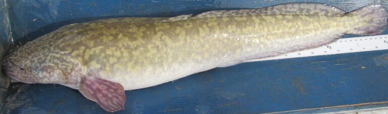
Photo: USFWS Mountain-Prairie, Public domain

Photo: USFWS Mountain-Prairie, Public domain
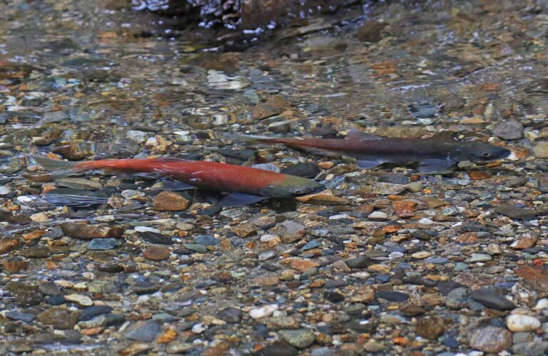
Photo: Judy Gallagher, CC BY 2.0
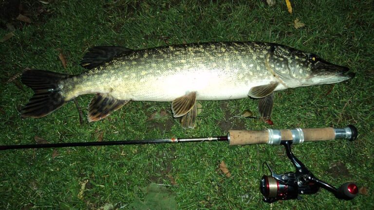
Photo: Aszazin, CC BY-SA 3.0

Short replies about fishing San Juan County
How many boat launches does San Juan County have in the Utah data?
The launch layers list 9 launches.
Which San Juan County lake tops the size figures?
On size, Recapture Reservoir: about 221 acres of mapped outline.
Which species keep appearing in DWR lists around San Juan County?
Fish Utah rates rainbow trout likely or possible on the most lakes within 40 miles, then green sunfish, largemouth bass and tiger trout.
Does San Juan County have a Utah marina or bait counter?
There are 1; Halls Crossing Marina comes first.
Which Utah town is the seat for San Juan County?
County offices sit in Monticello.
Do I need a Utah license to fish in San Juan County?
Plan on $40 with Utah residency or $120 without it for an adult 365-day license; anglers under 12 need none.
Which Utah counties lie closest to San Juan County?
Wayne County, Garfield County and Grand County sit nearest.
What trout figures apply to San Juan County water?
Statewide, the trout, kokanee and grayling row sets a daily limit 4 under the 2027 guidebook; the 2026 guidebook prints the same number. Waters with their own entry can differ.
Does DWR stock fish in San Juan County?
The 2026 DWR table lists 243,006 fish in 29 rows across 11 waters in the county.
Has a Utah record fish come from San Juan County?
Channel catfish, 36 ¾", from Kens Lake (2015).
Hitch the boat for Utah water in San Juan County
Open a lake for its launches, limits and Reclamation readings.