Nonesuch River Fishing
A tidal water in Cumberland County, Maine.
 Pick for troutPiscifun Carbon X ultralight spinning reel28% OFFSale $57.99
Photo of Portland: Paul VanDerWerf, CC BY 2.0
Where anglers from Nonesuch River go in Maine
A tidal water of Cumberland County, Nonesuch River turns up through the launches mapped on it. Tide marks on the ramps: 1 part-tide ramp. The nearest listed town is Scarborough, under a mile away.
The launch layer lists 1 launch here. Shore fishing sites on file: 3 sites.
Maine GeoLibrary boat launches layer (ArcGIS service), read November 18, 2026.
U.S. Census Bureau, 2020 Census counts (TIGERweb) and the 2023 Gazetteer, read November 18, 2026.
Dated NOAA readings for Nonesuch River
Portland is the gauge to watch for Nonesuch River, 7 miles off; tides at Nonesuch River itself can differ.
NOAA CO-OPS Portland station readings for Nonesuch River, retrieved November 18, 2026.
NOAA CO-OPS station Portland (tidesandcurrents.noaa.gov), reading time stamped in GMT on the line above, retrieved November 18, 2026. Not live; the water level is relative to MLLW.
Pine Point, Scarborough River is the closest tide-prediction station.
Hauling a boat up the logging road to Nonesuch River
- Nonesuch River (Scarborough) Fishing Areatrailer ramp, part-tide ramp, hard surface
Casting from the Maine shore at Nonesuch River
- Clay Pits/Nonesuch Boat Ramp on Nonesuch Rivercoastal public access site
- Old Neck Landing on Nonesuch Rivercoastal public access site
- Winnock's Neck Fishing Area on Nonesuch Rivercoastal public access site
Nothing here states when a launch is open or what it costs; check with its owner.
Maine GeoLibrary boat launches layer (ArcGIS service), read November 18, 2026.
Limits to check before keeping a fish at Nonesuch River
No water-by-water special law was read for Nonesuch River. Special laws that apply to single lakes, such as closures, ice seasons and bait or length changes, were not read here, so look up the special fishing laws page for the water first.
| Fish as printed | Water type | Daily bag as printed | Possession | Note |
|---|---|---|---|---|
| Brook trout (includes splake, Arctic charr) | lakes ponds | 5 fish total; only 2 from South Zone lakes/ponds | 6 in minimum | |
| Brook trout (includes splake, Arctic charr) | rivers streams brooks | 5 | 6 in minimum | |
| Brown trout | lakes ponds | 2 | 14 in minimum | |
| Brown trout | rivers streams brooks | 2 | 6 in minimum, 25 in maximum | |
| Rainbow trout | lakes ponds | 2 | 12 in minimum | |
| Rainbow trout | rivers streams brooks | 2 | 6 in minimum | |
| Landlocked salmon | lakes ponds | 2 | 14 in minimum | |
| Landlocked salmon | rivers streams brooks | 2 | 14 in minimum, 25 in maximum | Page: Aug 16-Sep 30 river stream limits are one landlocked salmon and one brook trout daily. |
| Togue (lake trout) | lakes ponds | 2 | 18 in minimum | |
| Togue (lake trout) | rivers streams brooks | 2 | 18 in minimum | |
| Bass (largemouth and smallmouth) | all | North Zone: unlimited; South Zone: 2, only 1 may exceed 14 in | North: no length limit; South: no minimum | |
| Whitefish | lakes ponds | 3 | none |
Source for the rules: MDIFW statewide fishing law pages, Nov. 18, 2026 reading; undated pages, a 2026 law book good through Dec. 31, 2026, and no 2027 numbers.
Inland fishing in Maine takes a license from age 16: the MDIFW fees page lists $30 for a resident season license and $83 for a nonresident season license, before agent fees.
MDIFW fishing law pages for 2026 (maine.gov/ifw), read November 18, 2026. The pages carry no revision date and refer to the 2026 fishing law book, which is not valid after Dec. 31, 2026.
License fees from the MDIFW license requirements page (maine.gov/ifw), read November 18, 2026.
 For the trout herePiscifun Carbon XT ultralight spinning reel25% OFFSale $59.99
Coastal rules to read before fishing Nonesuch River
Striped bass rules from the DMR, dated 25 March 2026, apply on tidal water such as Nonesuch River.
| Item | Rule as printed |
|---|---|
| Season | Jan 1 – Dec 31 (except Kennebec watershed) |
| Daily bag | 1 |
| Slot | 28 to 31 in inclusive total length |
| Gear | Hook and line only; no gaffing; no bait with treble hooks; max two treble hooks per lure/fly in territorial waters; bait requires non-offset circle hook (tube lure exception: 8 in or longer with a single hook) |
| Where it applies | Coastal waters to head of tide; unlawful beyond 3 miles from shore |
Local exceptions listed: Saco River (Fishing unlawful upstream of Route 9/Main Street bridge to head of tide (Cataract Dam)); Kennebec watershed (incl. Sheepscot and Androscoggin Rivers, bays, tributaries to head of tide) (Catch and release May 1 – Jun 30, single-hook artificial lures only (one treble allowed), no marine bait; open Jul 1 – Nov 30; closed Dec 1 – Jun 30 except catch and release season); Dams with fishways (Within 150 ft of dam with fishway or any part of fishway closed to fishing for all species).
Before fishing tidal water, note this registry rule: No fishing recreationally in coastal waters, or landing/possessing fish from them, without registering unless exempt; individuals only; halibut anglers must register and get halibut tags regardless of exemptions
Maine DMR 2026 striped bass regulations (current as of 25 March 2026) and 12 MRSA 6312 (text current through 1 Oct 2026), read November 18, 2026.
Places mapped beside Nonesuch River
Ponds and lakes worth a detour from Nonesuch River
- Scarborough River2 miles south
- Fore River7 miles northeast
- Saco River8 miles southwest
- Presumpscot River11 miles north
- Casco Bay13 miles northeast
Shops to pass on the way to Nonesuch River
- Cabela'sbait and tackle shop, Scarborough, 3 miles
- Saco Bay Tackle Cobait and tackle shop, Saco, 4 miles
- Dick's Sporting Goods (South Portland)bait and tackle shop, South Portland, 5 miles
- Aspasia Marinamarina, South Portland, 7 miles
- Sunset Marinamarina, South Portland, 7 miles
- DiMillo's Old Port Marinamarina, Portland, 7 miles
Booking a guided Maine day around Nonesuch River
- Maine Fishing Chartercharter, Scarborough
- Mary May Charterscharter, South Portland
- No Slack! Sportfishing Charterscharter, South Portland
- Teazer Charterscharter, South Portland
- Bucktail Guide Servicefishing guide, South Portland
- Maine Bass Fishing Guide Servicefishing guide, Brunswick
- Mainely Bluefishing guide, South Portland
- North Creek Guide Servicefishing guide, North Yarmouth
Maine towns with beds near Nonesuch River
- Scarboroughunder a mile
- Oak Hill2 miles
- Old Orchard Beach3 miles
Counties touching Nonesuch River across the Pine Tree State
- Cumberland Countyseat: Portland
A Piscifun bundle sized for Maine ponds and brooks like Nonesuch River


Piscifun and Amazon links are affiliate links; the site earns a commission on qualifying purchases.
First light over the water near Nonesuch River, Maine style
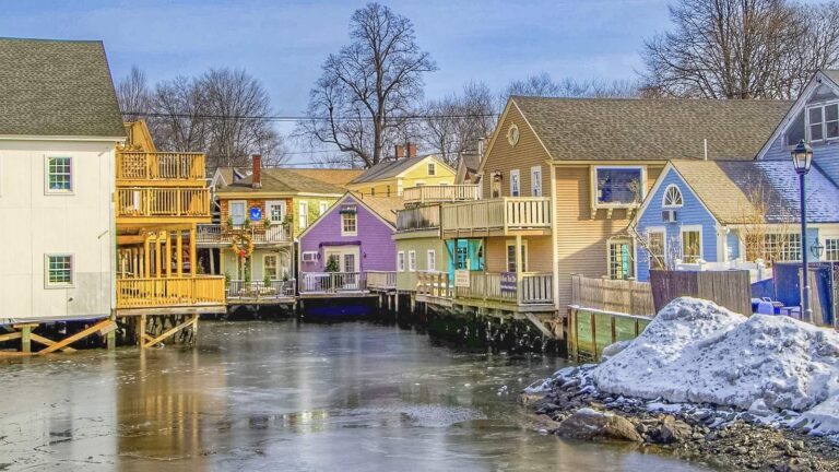
Photo: Dennis Weeks, CC BY 4.0

Photo: John Marino, CC BY 2.0

Photo: Dennis Weeks, CC BY 4.0

Photo: Paul VanDerWerf, CC BY 2.0
Nonesuch River answered in a few plain questions
Which part of the Maine coast holds the Nonesuch River?
Quick check: Nonesuch River is in Cumberland County, nearest town Scarborough.
What launches are mapped at the Nonesuch River?
In practice: Launch data count 1 launch, including Nonesuch River (Scarborough) Fishing Area. The layer gives no lanes, hours or fees.
What must a saltwater angler do at the Nonesuch River?
Plainly: The DMR saltwater registry applies to recreational fishing in coastal waters unless an exemption holds; the registry rule is quoted on the page with its source.
What is the striped bass limit near the Nonesuch River?
Quick check: The DMR sheet current as of 25 March 2026 lists a daily bag and a slot for striped bass; the page reproduces them with the area exceptions.
Where is the nearest tide station to the Nonesuch River?
In practice: The nearest NOAA water-level station is Portland, about 7 miles away; each reading carries its GMT time.
Does the shop list reach near the Nonesuch River?
Plainly: Cabela's, about 3 miles away, is first on the list.
Which town serves the Nonesuch River?
Quick check: Scarborough is the closest town on the Census list, under a mile away by straight line.
Which other pages cover waters close to the Nonesuch River?
In practice: Closest with their own page: Scarborough River, Fore River and Saco River.
What do I enter in a map app for the Nonesuch River?
Plainly: Use the Directions button on the page: it opens a map at the point the state data places the Nonesuch River. Access can change, so ask the landowner or town first.
Choose a first-light start at Nonesuch River
Check fees and the registry first.