Fishing in Owyhee County, Idaho
County seat: Murphy. Population 11,913.
- 51lake pages
- 12launch sites
- 11river pages
 Pick for sunfishPiscifun Carbon X ultralight spinning reel28% OFFSale $57.99
Photo of Owyhee River: BLMIdaho, CC BY 2.0
Reservoirs, creeks and launches of Owyhee County at a glance
Owyhee County keeps its courthouse in Murphy, and the 2020 Census put 11,913 people inside the county. The IDFG Fishing Planner files 87% of the county's listed waters under the IDFG Southwest Region; drainage lines, not the county line, decide the rest.
Lake guides cover 51 waters totalling 13,899 acres; C. J. Strike Reservoir is the biggest. Agency maps show 12 launch sites (7 IDFG and 5 BLM). IDFG maps 1 walk-in access site for anglers on foot.
Census 2020 population and county seat; IDFG Idaho Fishing Planner (list of Idaho waters), read November 7, 2026. IDFG Fishing and Boating Access Sites layer (ArcGIS service), read November 7, 2026.
A map of Owyhee County launches and lake points
IDFG Fishing and Boating Access Sites, BLM and Forest Service launch points, Fishing Planner lake points (outlet) and stream midpoints. Checked November 2026.
Owyhee County lakes and reservoirs with their own page
| Lake | Acres | Launches | Kind | Game fish IDFG names |
|---|---|---|---|---|
| C. J. Strike Reservoir | 6,760 | 2 | reservoir | bluegill and sunfish, bullhead, white sturgeon |
| Ross Lake | 1,002 | 0 | lake | |
| Juniper Basin Reservoir | 708 | 0 | reservoir | |
| Swan Falls Reservoir | 470 | 0 | reservoir | bluegill and sunfish, bullhead, white sturgeon |
| Mountain View Lake | 406 | 0 | lake | |
| Juniper Lake | 389 | 0 | lake | |
| Rough Lake | 331 | 0 | lake | |
| Little Jarvis Lake | 282 | 0 | lake | |
| Bybee Reservoir | 236 | 0 | reservoir | cutthroat trout, bridgelip sucker, redside shiner |
| Grasmere Reservoir | 224 | 0 | reservoir | cutthroat trout, bridgelip sucker, rainbow trout |
| Succor Creek Reservoir | 207 | 0 | reservoir | rainbow trout, redband trout, bridgelip sucker |
| Whites Reservoir | 194 | 0 | reservoir | |
| Blue Creek Reservoir (Owyhee County) | 184 | 0 | reservoir | largescale sucker, northern pikeminnow |
| Henry Lake | 172 | 0 | lake | |
| Little Blue Creek Reservoir | 140 | 0 | reservoir | cutthroat trout, bridgelip sucker, redside shiner |
| Mud Flat Lake | 121 | 0 | lake | |
| Buckhorn Reservoir | 113 | 0 | reservoir | |
| Dunes Lake | 99 | 0 | lake | bluegill and sunfish, largemouth bass, rainbow trout |
| Pot Hole Reservoir | 99 | 0 | reservoir | |
| Indian Lake (Owyhee County) | 94 | 0 | lake | |
| Crane Falls Lake | 89 | 0 | lake | bluegill and sunfish, largemouth bass, rainbow trout |
| Shoofly Reservoir | 88 | 0 | reservoir | bluegill and sunfish, cutthroat trout, cutthroat trout – lahontan |
| Otter Reservoir | 87 | 0 | reservoir | |
| Lower Nichol Flat Reservoir | 86 | 0 | reservoir | |
| Big Lake (Owyhee County, 83 acres) | 83 | 0 | lake | |
| Triangle Reservoir | 83 | 0 | reservoir | |
| Battle Creek Lakes | 80 | 0 | lake | |
| Cove Arm Reservoir | 76 | 1 | reservoir | bluegill and sunfish, bullhead, largemouth bass |
| Dougal Reservoir | 75 | 0 | reservoir | |
| Payne Creek Reservoir | 74 | 0 | reservoir | bridgelip sucker, cutthroat trout |
| Foremans Reservoir | 64 | 0 | reservoir | |
| Forster Reservoir | 62 | 0 | reservoir | |
| Inside Lakes | 58 | 0 | lake | |
| Big Lake (Owyhee County, 55 acres) | 55 | 0 | lake | |
| Bruneau Duck Pond South | 54 | 0 | lake | |
| Anderson Reservoir | 50 | 0 | reservoir | |
| Twin Lakes Reservoir (Owyhee County) | 50 | 0 | reservoir | |
| Sage Hen Reservoir (Owyhee County) | 42 | 0 | reservoir | bridgelip sucker, northern pikeminnow |
| Dry Lake | 39 | 0 | lake | |
| Star Reservoir | 39 | 0 | reservoir | |
| Homer Wells Reservoir | 36 | 0 | reservoir | |
| Bruneau Dunes Pond North | 35 | 0 | lake | bluegill and sunfish, common carp, largemouth bass |
| Brace Reservoir | 35 | 0 | reservoir | |
| Blackstone Reservoir | 34 | 0 | reservoir | |
| O X Lake | 34 | 0 | lake | |
| Tindall Reservoir | 31 | 0 | reservoir | |
| Spencer Reservoir | 29 | 0 | reservoir | |
| Bull Creek Reservoir | 28 | 0 | reservoir | |
| Boyle Creek Reservoir | 27 | 0 | reservoir | |
| Claytonia Pond | 26 | 0 | lake | bluegill and sunfish, largemouth bass, channel catfish |
| Indian Creek Reservoir (Owyhee County) | 19 | 0 | reservoir | bluegill and sunfish, largemouth bass, bullhead |
Surface acres as listed in the IDFG Idaho Fishing Planner, read November 7, 2026. Game fish are the Planner’s recommended species; IDFG prints no lake depths there.
 For the sunfish herePiscifun Carbon XT ultralight spinning reel25% OFFSale $59.99
Which fish the Planner ties to water near Owyhee County
Out to 50 miles from Murphy, bluegill and sunfish turns up on the most lake pages.
IDFG Fishing Planner recommended game fish and stocking rows, counted per lake page within 50 miles; not a creel survey.
More named Owyhee County lakes on the Planner list
Another 132 named lakes in Owyhee County have too few published facts for a page and are listed here by size.
| Water | Acres | Kind | Nearest town |
|---|---|---|---|
| Long Lake | 26 | lake | Glenns Ferry |
| Fivemile Lake | 24 | lake | Mountain Home AFB |
| Whitby Reservoir | 22 | reservoir | Mountain Home AFB |
| Tent Creek Reservoir | 21 | reservoir | Mountain Home AFB |
| Cowan Reservoir | 21 | reservoir | Buhl |
| Jacks Creek Reservoir | 20 | reservoir | Mountain Home AFB |
| East Horse Basin Reservoir | 20 | reservoir | Mountain Home AFB |
| Catholic Lake | 16 | lake | Glenns Ferry |
| Hackberry Reservoir | 15 | reservoir | Mountain Home AFB |
| Bruneau Duck Pond North | 15 | lake | Mountain Home AFB |
| Cedar Tree Trail Lakes | 14 | lake | Glenns Ferry |
| Twin Lakes | 14 | lake | Glenns Ferry |
| Monument Lake | 12 | lake | Glenns Ferry |
| James Lake | 12 | lake | Glenns Ferry |
| Twin Lakes | 11 | lake | Glenns Ferry |
| White Lake | 10 | lake | Glenns Ferry |
| Eds Defeat Reservoir | 10 | reservoir | Mountain Home AFB |
| Harris Lake | 9 | lake | Mountain Home AFB |
| Rock Lake | 8 | lake | Mountain Home AFB |
| Wilson Lake | 8 | lake | Buhl |
| Horse Lake | 7 | lake | Buhl |
| Upper Twin Lakes | 7 | lake | Glenns Ferry |
| Rattlesnake Reservoir | 7 | reservoir | Mountain Home AFB |
| Antelope Flat Reservoir | 6 | reservoir | Mountain Home AFB |
| Johnson Reservoir | 6 | reservoir | Mountain Home AFB |
| Sewell Reservoir | 6 | reservoir | Mountain Home AFB |
| Idaho Lakes | 6 | lake | Buhl |
| Bennett Reservoir | 5 | reservoir | Mountain Home AFB |
| West Horse Basin Reservoir | 5 | reservoir | Mountain Home AFB |
| Four Corners Reservoir | 4 | reservoir | Mountain Home AFB |
| Johnston Lakes | 4 | lake | Marsing |
| Marsing Pond | 4 | lake | Marsing |
| Coyote Flat Reservoir | 4 | reservoir | Mountain Home AFB |
| Salvador Lake | 4 | lake | Glenns Ferry |
| Little Juniper Basin Reservoir | 3 | reservoir | Mountain Home AFB |
| Kimball Basin Reservoir | 3 | reservoir | Mountain Home AFB |
| Triguero Lake | 3 | lake | Buhl |
| Upper Paiute Creek Reservoir | 3 | reservoir | Mountain Home AFB |
| Hinton Reservoir | 3 | reservoir | Mountain Home AFB |
| Weather Station Reservoir | 2 | reservoir | Mountain Home AFB |
| Big Lakes | 2 | lake | Buhl |
| Broken Wagon Flat Reservoir | 2 | reservoir | Mountain Home AFB |
| Dry Creek Reservoir | 2 | reservoir | Mountain Home AFB |
| 71 Draw Reservoir | 2 | reservoir | Buhl |
| Diversion Reservoir | 2 | reservoir | Mountain Home AFB |
| Breakdown Reservoir | 2 | reservoir | Mountain Home AFB |
| Correction Reservoir | 2 | reservoir | Mountain Home AFB |
| Little Horse Basin Reservoir | 1 | reservoir | Mountain Home AFB |
| Rocky Lake | 1 | lake | Buhl |
| Shea Reservoir | 1 | reservoir | Mountain Home AFB |
| Shearing Corral Reservoir | 1 | reservoir | Mountain Home AFB |
| Table Reservoir | 1 | reservoir | Mountain Home AFB |
| Walcot Basin Reservoir | 1 | reservoir | Mountain Home AFB |
| Corral Reservoir | 1 | reservoir | Glenns Ferry |
| Stump Lake | 1 | lake | Mountain Home AFB |
| Bull Camp Reservoir | 1 | reservoir | Mountain Home AFB |
| Cleveland Reservoir | 1 | reservoir | Mountain Home AFB |
| Little Blue Table Reservoir | 1 | reservoir | Mountain Home AFB |
| State Line Reservoir | 1 | reservoir | Mountain Home AFB |
| Dickshooter Reservoir | 1 | reservoir | Mountain Home AFB |
| Grassy Hills Reservoir | 1 | reservoir | Buhl |
| Mosquito Lake Reservoir | 1 | reservoir | Buhl |
| Packsaddle Reservoir | 1 | reservoir | Mountain Home AFB |
| Petition Reservoir | 1 | reservoir | Mountain Home AFB |
| Poison Creek Reservoir | 1 | reservoir | Buhl |
| Turner Reservoir | 1 | reservoir | Mountain Home AFB |
| Juniper Basin Reservoir | 1 | reservoir | Mountain Home AFB |
| Wiley Reservoir | 1 | reservoir | Mountain Home AFB |
| Harveys Canyon Reservoir | 1 | reservoir | Mountain Home AFB |
| Last Chance Reservoir | 1 | reservoir | Mountain Home AFB |
| Sundown Reservoir | 1 | reservoir | Mountain Home AFB |
| Two Mile Limit Reservoir | 1 | reservoir | Mountain Home AFB |
| Upper Antelope Reservoir | 1 | reservoir | Mountain Home AFB |
| Aikers Reservoir | 0 | reservoir | Buhl |
| Jackson Reservoir | 0 | reservoir | Mountain Home AFB |
| Long Pull Reservoir | 0 | reservoir | Mountain Home AFB |
| Mud Reservoir | 0 | reservoir | Mountain Home AFB |
| Y P Reservoir # | 0 | reservoir | Mountain Home AFB |
| Beck Reservoir | 0 | reservoir | Mountain Home AFB |
| Duncan Creek Reservoir | 0 | reservoir | Mountain Home AFB |
| Harveys V Reservoir | 0 | reservoir | Mountain Home AFB |
| John G Reservoir | 0 | reservoir | Mountain Home AFB |
| Little Grassy Reservoir | 0 | reservoir | Buhl |
| Millin Reservoir | 0 | reservoir | Mountain Home AFB |
| Rattlesnake Draw Reservoir | 0 | reservoir | Buhl |
| Sailor Creek Lake | 0 | lake | Buhl |
| Black Leg Reservoir | 0 | reservoir | Buhl |
| Bullhead Reservoir | 0 | reservoir | Mountain Home AFB |
| Cinnabar Reservoir | 0 | reservoir | Mountain Home AFB |
| Dryden Reservoir | 0 | reservoir | Marsing |
| Jim Bob Reservoir | 0 | reservoir | Buhl |
| McGregor Reservoir | 0 | reservoir | Buhl |
| Middle Bench Reservoir | 0 | reservoir | Mountain Home AFB |
| North Big Springs Reservoir | 0 | reservoir | Mountain Home AFB |
| Slate Reservoir | 0 | reservoir | Mountain Home AFB |
| Timber Draw Reservoir | 0 | reservoir | Mountain Home AFB |
| Upper John G Reservoir | 0 | reservoir | Mountain Home AFB |
| Willies Reservoir | 0 | reservoir | Mountain Home AFB |
| Willow Creek Reservoir | 0 | reservoir | Mountain Home AFB |
| Antelope Creek Canyon Reservoir | 0 | reservoir | Glenns Ferry |
| Felix Reservoir | 0 | reservoir | Buhl |
| Lahtinen Spring Reservoir | 0 | reservoir | Mountain Home AFB |
| Lake Pit Reservoir | 0 | reservoir | Buhl |
| Monasterio-Jacks Creek Reservoir | 0 | reservoir | Mountain Home AFB |
| North Lambert Reservoir | 0 | reservoir | Mountain Home AFB |
| Owens Reservoir | 0 | reservoir | Mountain Home AFB |
| Poison Creek Reservoir | 0 | reservoir | Buhl |
| Rock Point Reservoir | 0 | reservoir | Mountain Home AFB |
| Shirk Reservoir | 0 | reservoir | Buhl |
| South Bench Reservoir | 0 | reservoir | Mountain Home AFB |
| Upper Rattlesnake Reservoir | 0 | reservoir | Mountain Home AFB |
| White Rock Reservoir | 0 | reservoir | Mountain Home AFB |
| Wickney Tree Reservoir | 0 | reservoir | Mountain Home AFB |
| Bald Mountain Reservoir | 0 | reservoir | Mountain Home AFB |
| Bert Monday Reservoir | 0 | reservoir | Mountain Home AFB |
| Bitterbrush Reservoir | 0 | reservoir | Mountain Home AFB |
| Elk Reservoir | 0 | reservoir | Mountain Home AFB |
| Flat Draw Reservoir | 0 | reservoir | Buhl |
| Jus Reservoir | 0 | reservoir | Mountain Home AFB |
| Lower Antelope Reservoir | 0 | reservoir | Mountain Home AFB |
IDFG Idaho Fishing Planner (list of Idaho waters), read November 7, 2026.
Rivers and trout creeks of Owyhee County
- Jarbidge RiverIDFG recommended water, 1 launch, 51.6 mi Planner length
- Owyhee RiverIDFG recommended water, 161.3 mi Planner length
- Bruneau RiverIDFG recommended water, 1 USGS gauge, 152.9 mi Planner length
- Jordan CreekIDFG recommended water, 98.6 mi Planner length
- Deep Creek1 launch, 39.5 mi Planner length
- Snake River1 launch, 14 USGS gauges
- Big Jacks Creek1 USGS gauge, 59.8 mi Planner length
- South Fork Owyhee River35.6 mi Planner length
- North Fork Owyhee River33.3 mi Planner length
- East Fork Jarbidge River24.7 mi Planner length
- Middle Fork Owyhee River24.1 mi Planner length
Owyhee County creeks the Planner names, listed here only (470)
- Succor Creek70.5 mi
- Battle Creek66.9 mi
- Sailor Creek66.5 mi
- Sheep Creek62.8 mi
- Clover Creek55.5 mi
- Blue Creek51.9 mi
- Devil Creek44.9 mi
- Marys Creek43.3 mi
- Poison Creek41.5 mi
- Deadman Creek39.8 mi
- Pot Hole Creek39.1 mi
- Castle Creek33 mi
- Little Jacks Creek31.2 mi
- Rock Creek30.6 mi
- Sugar Creek29.6 mi
- Buck Flat Draw29.2 mi
- South Canal29 mi
- Soldier Creek28.5 mi
- Birch Creek28.1 mi
- Reynolds Creek25.4 mi
- Jump Creek25.3 mi
- Rosevear Gulch25.1 mi
- Louse Creek24.3 mi
- Pole Creek24.1 mi
- Cougar Creek23.6 mi
- Shoofly Creek23.2 mi
- Dickshooter Creek23.1 mi
- Fossil Creek22.5 mi
- Hot Creek22.1 mi
- Unnamed Stream21.2 mi
- Shoofly Creek21 mi
- Dorsey Creek20.7 mi
- Payne Creek20.6 mi
- Cherry Creek20.5 mi
- Vinson Wash20.5 mi
- Yatahoney Creek20.5 mi
- Deadwood Creek20.2 mi
- Rabbit Creek19.9 mi
- Cat Creek19.6 mi
- Three Creek18.8 mi
- Poison Creek18.5 mi
- Wickahoney Creek18.4 mi
- Cherry Creek18.3 mi
- Browns Creek17.7 mi
- Newe Waippe Naokwaide17.4 mi
- Big Springs Creek17.2 mi
- Paiute Creek17.1 mi
- Pickett Creek17.1 mi
- McBride Creek17 mi
- Unnamed Stream17 mi
- Juniper Draw16.9 mi
- Little Owyhee River16.8 mi
- North Boulder Creek16.8 mi
- Duncan Creek16.7 mi
- Lone Tree Creek16.7 mi
- Sinker Creek16.4 mi
- Miller Water16.3 mi
- Dry Creek16.2 mi
- Hart Creek15.6 mi
- Juniper Creek15.5 mi
- Sage Creek15.5 mi
- Paa-ba Tehaga Creek15.4 mi
- Bull Gulch14.9 mi
- North Fork Castle Creek14.9 mi
- Camas Creek (Owyhee County)14.7 mi
- Jacks Creek14.6 mi
- Big Flat Creek14.2 mi
- South Boulder Creek14.1 mi
- Pole Creek14 mi
- Rattlesnake Creek14 mi
- Columbet Creek13.8 mi
- Nickel Creek13.7 mi
- Poison Gulch13.5 mi
- Cow Creek13.3 mi
- Current Creek13.3 mi
- Unnamed Stream13.3 mi
- Josephine Creek13.2 mi
- McKeeth Wash13.2 mi
- Unnamed Stream13.2 mi
- Big Pilgrim Gulch13.1 mi
Live river readings in Owyhee County
| USGS gauge | Latest reading | Time (ET) |
|---|---|---|
| Bruneau River Nr Hot Spring Id | 44 cfs, 4.54 ft gage height | Nov 12 8:00 pm |
| Ef Owyhee River At Crutcher Crossing, Id | 18 cfs, 8.14 ft gage height | Nov 12 8:00 pm |
| Big Jacks Creek At Parker Trail Nr Grasmere, Id | 3 cfs, 4.38 ft gage height | Nov 12 7:45 pm |
US Geological Survey provisional data, retrieved Nov 12, 2026 8:32 pm ET. Provisional readings can be revised.
IDFG Idaho Fishing Planner (list of Idaho waters), read November 7, 2026. Stream lengths as printed in the Planner; USGS gauges live.
Stocking rows for Owyhee County water
IDFG lists 709 hatchery releases into Owyhee County water on its Planner pages: 7,404,449 fish in 11 waters.
- Snake RiverRainbow Trout – Triploid, 500 fish, Catchable (12-14 inches), October 27, 2026
- Snake RiverRainbow Trout – Triploid, 21,576 fish, Catchable (6+ inches), October 22, 2026
- Crane Falls LakeRainbow Trout – Triploid, 1,225 fish, Catchable (6+ inches), October 22, 2026
- Snake RiverRainbow Trout – Triploid, 5,846 fish, Catchable (12-14 inches), October 21, 2026
- Shoofly ReservoirCutthroat Trout – Lahontan, 2,684 fish, Fingerling (3-6 inches), October 9, 2026
- Grasmere ReservoirCutthroat Trout – Lahontan, 6,263 fish, Fingerling (3-6 inches), October 9, 2026
- Grasmere ReservoirCutthroat Trout – Lahontan, 21,474 fish, Fingerling (3-6 inches), October 8, 2026
- Owyhee RiverChinook Salmon, 150 fish, Adults, July 1, 2026
- Snake RiverRainbow Trout – Triploid, 2,000 fish, Catchable (6+ inches), June 3, 2026
- Snake RiverRainbow Trout – Triploid, 2,500 fish, Catchable (6+ inches), May 21, 2026
- Snake RiverBrown Trout, 20,000 fish, Fingerling (3-6 inches), April 9, 2026
- Snake RiverBrown Trout, 21,502 fish, Fingerling (3-6 inches), April 8, 2026
Stocking rows as printed on the IDFG Fishing Planner water pages (date, species, number and size as listed), read November 7, 2026. Newest releases first.
Launches and walk-in access of Owyhee County
- Bernards Landinglaunch site, IDFG, boating access, ramp, dock, restroom
- Bruneau Arm Narrows boat ramp on C. J. Strike ReservoirC. J. Strike Reservoir, IDFG, ramp, dock, restroom, camping
- Clarks Island launchlaunch site, IDFG, boating access
- Cove Arm boat rampCove Arm Reservoir, IDFG, fishing access, ramp, dock, restroom, camping
- Crane Falls boat ramp on C. J. Strike ReservoirC. J. Strike Reservoir, IDFG, boating access, ramp, dock, restroom, camping
- Marsing boat ramplaunch site, IDFG, boating access, ramp, restroom
- Walters Ferry boat ramplaunch site, IDFG, boating access, ramp, dock, restroom
- Crutcher Crossing launchlaunch site, BLM, boat launch
- Deep Creek launchDeep Creek, BLM, boat launch
- Garat Crossing launchlaunch site, BLM, boat launch
- Jarbidge River Launch SiteJarbidge River, BLM, boat launch
- Rickert Crossing launchlaunch site, BLM, boat launch
IDFG bank spots of Owyhee County (1)
- Claytonia fishing accessfishing access
IDFG Fishing and Boating Access Sites layer (ArcGIS service), read November 7, 2026. BLM and Forest Service points as published; lanes and ramp counts are not fields in any layer.
Fish an angler may keep across Owyhee County
This is the IDFG Southwest Region block, since most of Owyhee County's listed water sits in it; special rules printed for a water come first. The annual license fee written into Idaho Code 36-416 is $28.75 for an Idahoan and $106.25 for a visitor; GoOutdoorsIdaho and vendors add processing.
| Group | Rule as printed |
|---|---|
| Bass | Bass limit is 6, both species combined; None under 12 inches |
| Brook Trout | Brook Trout limit is 25; Harvest allowed during any open season unless otherwise noted under Special Rules – if gear or bait restrictions are listed, they apply when fishing for Brook Trout |
| Bull Trout | Bull Trout – catch-and-release |
| Kokanee | Kokanee limit is 6 |
| Salmon | Spring and summer Chinook Salmon seasons and limits are set by the Idaho Fish and Game Commission and issued in separate brochures; Seasons and limits for fall Chinook Salmon and Coho Salmon can be found here; Sockeye Salmon fishing is illegal. Defined as ocean-run Oncorhynchus nerka longer than 14 inches in the Snake River drainage below Hells Canyon Dam, the Salmon River drainage (excluding above Mosquito Flat Dam) |
| Steelhead | Defined as Rainbow Trout longer than 20 inches in the Salmon River drainage (excluding lakes and reservoirs). Between Hells Canyon Dam and Oxbow Dam and the Boise River from its mouth upstream to Barber Dam during steelhead seasons, steelhead are Rainbow Trout over 20 inches with the adipose fin clipped (as evidenced by a healed scar); Fishing for steelhead is prohibited unless a steelhead season is specifically open |
| Sturgeon | Sturgeon – catch-and-release; Sturgeon must not be removed from the water and must be released upon landing; Barbless hooks, sliding swivel device to secure a weight, and a lighter test line to secure weight to sliding swivel device are required. See fishing regulations for details |
| Tiger Muskie | Tiger Muskie limit is 2, none under 40 inches |
| Trout | Trout limit is 6, all species combined; Chinook Salmon and steelhead placed in ponds are counted in the trout bag limit; Bull Trout and Brook Trout are listed separately |
| Walleye | No bag, length, or possession limits. Harvest is encouraged (Stocked illegally in this Region. May be harmful to existing fisheries.) |
| Whitefish | Whitefish limit is 25; Harvest allowed during any open season unless otherwise noted under Special Rules – if gear or bait restrictions are listed, they apply when fishing for whitefish |
| Protected Nongame Fish | May not be harvested or possessed |
| All Other Fish Species | No bag, length, or possession limits |
A few listed waters belong to the IDFG Magic Valley Region. Every region table
Owyhee County water carrying special rules (20)
- Boyle Creek ReservoirContact the Duck Valley Indian Tribal Office
- Bruneau Dunes Pond NorthElectric motors only
- Bruneau RiverAll Waters Open All Year
- C. J. Strike ReservoirBass limit is 6, no minimum length, only 1 over 16 inches
- Crane Falls LakeElectric motors only
- Dry LakeContact the Duck Valley Indian Tribal Office
- Dunes LakeElectric motors only
- East Fork Jarbidge RiverAll Waters Open All Year
- Jarbidge RiverAll Waters Open All Year
- Jordan CreekAll Waters Open All Year
- Little Jarvis LakeContact the Duck Valley Indian Tribal Office
- Middle Fork Owyhee RiverAll Waters Open All Year
- Mountain View LakeContact the Duck Valley Indian Tribal Office
- North Fork Owyhee RiverAll Waters Open All Year
- Otter ReservoirContact the Duck Valley Indian Tribal Office
- Owyhee RiverAll Waters Open All Year
- Ross LakeContact the Duck Valley Indian Tribal Office
- Rough LakeContact the Duck Valley Indian Tribal Office
- Snake RiverAll Waters Open All Year
- South Fork Owyhee RiverAll Waters Open All Year
Region bag limits from Idaho Fishing Seasons and Rules, 2025-2027 for the Southwest Region, as printed on IDFG Fishing Planner water pages (the brochure PDF on idfg.idaho.gov was unreachable during site maintenance), read November 7, 2026. Fishing license fees as set in Idaho Code 36-416 (statute; IDFG sale prices add vendor and processing fees), read November 7, 2026.
Tackle, flies and outfitters in Owyhee County
Idaho tackle counters in Owyhee County
- Jump Creek Fliesbait and tackle shop, Homedale
Yellow Pages and chain store listings, guide listings (city of business); retrieved November 7, 2026.
Idaho highways leading out of Owyhee County
Motels and diners for a Owyhee County trip
- Homedalepop. 2,881
- Marsingpop. 1,229
Idaho county guides sharing a line with Owyhee County
- Ada County61 miles north
- Elmore County67 miles northeast
- Gooding County75 miles east
- Canyon County77 miles north
Rods, reels and pliers from Piscifun before Owyhee County


Piscifun and Amazon links are affiliate links; the site earns a commission on qualifying purchases.
Gem State fish to know on sight at Owyhee County
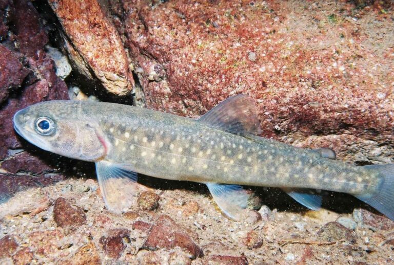
Photo: U.S. Fish and Wildlife Service, Public domain

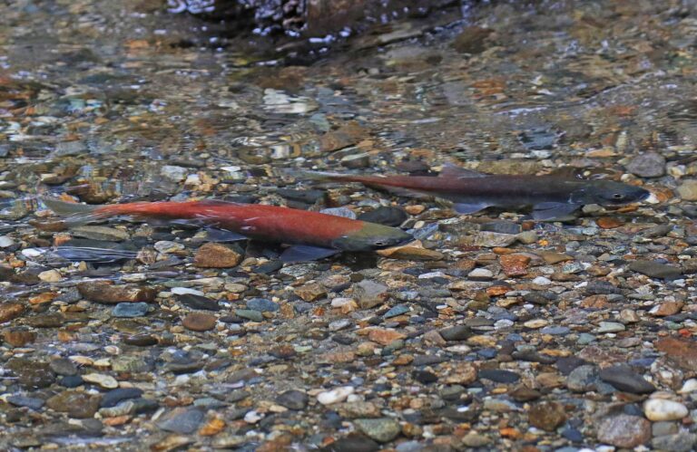
Photo: Judy Gallagher, CC BY 2.0
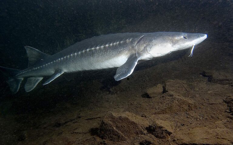
Photo: USFWS Fish and Aquatic Conservation, Public domain
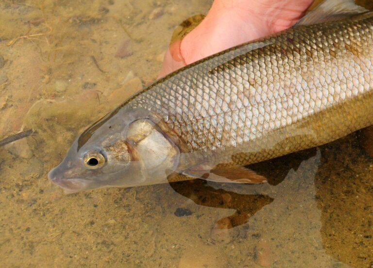
Photo: USFWS Mountain-Prairie, Public domain
Brief answers on fishing Owyhee County
How many IDFG, BLM and Forest Service launches serve Owyhee County?
12 launch sites on the access layers (7 IDFG and 5 BLM).
Which lake in Owyhee County does IDFG list with the most acres?
C. J. Strike Reservoir, at 6,760 acres in the IDFG Fishing Planner.
Which game fish does IDFG name on water near Owyhee County?
Bluegill and sunfish lead the count of lake pages within 50 miles, followed by largemouth bass, rainbow trout and yellow perch.
Which Owyhee County stores keep hooks and flies?
1 in all, starting with Jump Creek Flies.
How many Idaho guide listings name a Owyhee County town?
Idaho guide listings name no town inside the county.
Which Idaho town holds the Owyhee County county offices?
Murphy is the seat.
Does fishing in Owyhee County need an Idaho license?
The annual license fee written into Idaho Code 36-416 is $28.75 for an Idahoan and $106.25 for a visitor; GoOutdoorsIdaho and vendors add processing.
Which Idaho county guides ring Owyhee County?
The nearest county pages are Ada County, Elmore County and Gooding County.
Which IDFG region covers most Owyhee County water?
87% of the Planner waters sit in the IDFG Southwest Region.
Does IDFG print special rules for any Owyhee County water?
The Planner prints special rules for 20 county waters with a page here, starting with Boyle Creek Reservoir; the list above shows the first ones.
Does IDFG stock fish in Owyhee County?
709 IDFG releases listed on Planner pages, 7,404,449 fish; the newest went into Snake River on Oct. 27, 2026.
Choose an IDFG lake or river in Owyhee County
Open a lake for its launches, limits and releases.