Fishing in Oconee County, South Carolina
County seat: Walhalla. Population 78,607 (2020). SCDNR Region 1.
- 4lake pages
- 34landings
- 16river pages
 Pick for troutPiscifun Carbon X ultralight spinning reel28% OFFSale $57.99
Photo of Lake Hartwell: Scott Ritchie, CC BY 2.0
The fishing makeup of Oconee County
Walhalla is where Oconee County keeps its seat, in a county of 78,607 at the last census. By SCDNR access records, the county falls mostly in SCDNR Region 1. Sorted by size, Lake Hartwell heads the county's 4 lakes with pages.
Within the county line SCDNR places 34 landings and paddle launches and 55 piers and bank sites. Paddle or wade Chattooga River, Chauga River and Cedar Creek, each with a page. SCDNR flags Bee Creek, Brasstown Creek and Cedar Creek as trout water.
U.S. Census Bureau, 2020 Census counts (TIGERweb) and the 2023 Gazetteer, read November 9, 2026. SCDNR South Carolina Public Water Access layer (ArcGIS service, the data behind the SCDNR fishing access map), read November 9, 2026.
 For the trout herePiscifun Carbon XT ultralight spinning reel25% OFFSale $59.99
SCDNR access pins scattered over Oconee County
SCDNR Public Water Access layer and lake points, checked November 9, 2026.
Which Oconee County lakes have full write-ups
| Lake | Size | Landings | Kind | SCDNR species list |
|---|---|---|---|---|
| Lake Hartwell | 56,000 acres | 47 | major reservoir | Largemouth Bass, Alabama Bass, Black Crappie |
| Lake Keowee | 18,500 acres | 9 | major reservoir | Largemouth Bass, Alabama Bass, Black Crappie |
| Lake Jocassee | 7,500 acres | 5 | major reservoir | Largemouth Bass, Alabama Bass, Smallmouth Bass |
| Lake Tugaloo | about 427 acres of mapped outline | 1 | mapped lake | none on SCDNR lists |
Surface acres and depth as SCDNR prints them on its page for this lake, read November 9, 2026. Sizes SCDNR does not print show as mapped outline area. Species as SCDNR lists them at its access points.
Counting SCDNR species entries around Oconee County
Bars show how many lakes within 50 miles of Walhalla list each fish; Largemouth Bass tops the count.
SCDNR Public Water Access species lists, counted per lake page within 50 miles; an occurrence list, not a catch survey.
More Oconee County lakes known by name only
The SCDNR layers carry 6 more named ponds, pools and lakes in Oconee County.
| Water | Size | Kind |
|---|---|---|
| Yonah Lake | about 286 acres of mapped outline | mapped lake |
| Bad Creek Hydro Station | about 275 acres of mapped outline | mapped lake |
| Tallulah Falls Lake | about 56 acres of mapped outline | mapped lake |
| Oconee State Park Lake | not printed | named at an SCDNR access |
| Walhalla Reservoir | not printed | named at an SCDNR access |
| Whitewater River | not printed | named at an SCDNR access |
Outline area from the SCDNR Lakes and Reservoirs map layer (a GIS polygon area, not an SCDNR surface-acre figure), read November 9, 2026. SCDNR South Carolina Public Water Access layer (ArcGIS service, the data behind the SCDNR fishing access map), read November 9, 2026.
River and creek guides for Oconee County
- Chattooga RiverSCDNR trout water, shared with Georgia, 13 SCDNR accesses, 1 USGS gauge
- Chauga RiverSCDNR trout water, 12 SCDNR accesses, 1 USGS gauge
- Cedar CreekSCDNR trout water, 5 SCDNR accesses, 3 USGS gauges
- Brasstown CreekSCDNR trout water, 2 SCDNR accesses
- East Fork Chattooga RiverSCDNR trout water, 2 SCDNR accesses
- Bee CreekSCDNR trout water, 1 SCDNR access
- Cheohee CreekSCDNR trout water, 1 SCDNR access
- Corbin CreekSCDNR trout water, 1 SCDNR access
- Crane CreekSCDNR trout water, 1 SCDNR access
- Horse Bone Branch CreekSCDNR trout water, 1 SCDNR access
- Howard CreekSCDNR trout water, 1 SCDNR access
- Lick Log CreekSCDNR trout water, 1 SCDNR access
- North Fork Fall CreekSCDNR trout water, 1 SCDNR access
- Rocky Fork CreekSCDNR trout water, 1 SCDNR access
- Swaford CreekSCDNR trout water, 1 SCDNR access
- Whetstone CreekSCDNR trout water, 1 SCDNR access
Further Oconee County waterways (1)
- Cedar Creek (Chauga River Tributary)SCDNR trout water
USGS gauges reporting from Oconee County
| USGS gauge | Latest reading | Time (ET) |
|---|---|---|
| Chattooga River Near Clayton, Ga | 243 cfs, 1.32 ft gage height | Nov 12 6:00 pm |
| Coneross Ck Nr Seneca, Sc | 25 cfs, 3.30 ft gage height | Nov 12 6:15 pm |
| Chauga River Above Westminster, Sc | 7.87 ft gage height | Nov 12 5:15 pm |
US Geological Survey provisional data, retrieved Nov 12, 2026 6:33 pm ET. Provisional readings can be revised.
SCDNR South Carolina Public Water Access layer (ArcGIS service, the data behind the SCDNR fishing access map), read November 9, 2026. USGS Water Data for the Nation, live through the site, retrieved on page view.
SCDNR trout water inside Oconee County
- Bee CreekSCDNR trout water
- Brasstown Creektrout rows in the guide
- Cedar Creektrout stream
- Chattooga Riverlisted as trout water
- Chauga Rivertrout rules printed
- Cheohee Creektrout rows in the guide
- Corbin CreekSCDNR trout water
- Crane Creektrout rows in the guide
- East Fork Chattooga Rivertrout stream
- Horse Bone Branch Creektrout regulations apply
- Howard Creektrout stream
- Lick Log Creeklisted as trout water
- North Fork Fall Creektrout rules printed
- Rocky Fork Creektrout stream
- Swaford Creeklisted as trout water
- Whetstone Creektrout rows in the guide
South Carolina trout water rules
2026-2027 South Carolina Hunting & Fishing Guide, valid August 14, 2026 to August 14, 2027 (online guide), read November 9, 2026. SCDNR South Carolina Public Water Access layer (ArcGIS service, the data behind the SCDNR fishing access map), read November 9, 2026.
Where Oconee County boats go in
- Cane Creek Boat Ramp on Lake KeoweeLake Keowee, boat ramp, 2 lanes, concrete or paved, courtesy dock
- Chau-Ram Park on Chauga RiverChauga River, paddle launch
- Choestoa Park on Lake HartwellLake Hartwell, boat ramp, 1 lane, concrete or paved, courtesy dock
- Coneross Creek Boat Ramp on Lake HartwellLake Hartwell, boat ramp, 1 lane, concrete or paved, courtesy dock
- Double Springs (Devils Fork 1) Boat Ramp on Lake JocasseeLake Jocassee, boat ramp, 2 lanes, concrete or paved
- Fairplay Boat Ramp on Lake HartwellLake Hartwell, boat ramp, 2 lanes, concrete or paved, courtesy dock
- Fall Creek (North) Boat Ramp on Lake KeoweeLake Keowee, boat ramp, 3 lanes, concrete or paved, courtesy dock
- Friendship Boat Ramp on Lake HartwellLake Hartwell, boat ramp, 2 lanes, concrete or paved, courtesy dock
- High Falls Boat Ramp on Lake KeoweeLake Keowee, boat ramp, 1 lane, concrete or paved, courtesy dock, fishing pier
- Holders Boat Ramp on Lake HartwellLake Hartwell, boat ramp, 1 lane, concrete or paved
- Keowee Town AccessLake Keowee, boat ramp, 2 lanes, concrete or paved, courtesy dock
- Lake Hartwell State Park (north)Lake Hartwell, boat ramp, 1 lane, concrete or paved
- Lake Hartwell State Park (south)Lake Hartwell, boat ramp, 2 lanes, concrete or paved, courtesy dock, fishing pier
- Lake Tugalo Boat Ramp on Lake TugalooLake Tugaloo, boat ramp, 1 lane, concrete or paved
- Lawrence Bridge Boat Ramp on Lake HartwellLake Hartwell, boat ramp, 1 lane, concrete or paved, courtesy dock
- Main Boat Ramp (Jocassee 1) on Lake JocasseeLake Jocassee, boat ramp, 3 lanes, concrete or paved, courtesy dock
- Martin Creek Boat Ramp on Lake HartwellLake Hartwell, boat ramp, 1 lane, concrete or paved, courtesy dock
- Mullins Ford Boat Ramp on Lake HartwellLake Hartwell, boat ramp, 1 lane, concrete or paved, courtesy dock
- Oconee State ParkOconee State Park Lake, paddle launch
- River Bend Boat Ramp on Lake HartwellLake Hartwell, boat ramp, 1 lane, concrete or paved
- Roundhouse Point (Devils Fork 2) Boat Ramp on Lake JocasseeLake Jocassee, boat ramp, 1 lane, concrete or paved, courtesy dock
- Seneca Creek Boat Ramp on Lake HartwellLake Hartwell, boat ramp, 2 lanes, concrete or paved
- Seneca Creek Paddle Launch on Lake HartwellLake Hartwell, paddle launch, other (see comments)
- South Cove Boat Ramp on Lake KeoweeLake Keowee, boat ramp, 2 lanes, concrete or paved, courtesy dock, fishing pier
- South Union Boat Ramp on Lake HartwellLake Hartwell, boat ramp, 1 lane, concrete or paved
- Stamp Creek Access on Lake KeoweeLake Keowee, boat ramp, 1 lane, concrete or paved, courtesy dock
- Tabor Access on Lake HartwellLake Hartwell, boat ramp, 1 lane, concrete or paved
- Timberland Boat Ramp on Lake HartwellLake Hartwell, boat ramp, 1 lane, concrete or paved
- Villas Boat Ramp (Jocassee 2) on Lake JocasseeLake Jocassee, boat ramp, 2 lanes, concrete or paved, fishing pier
- Choestoa Park on Lake HartwellLake Hartwell, paddle launch
- Earl's Ford Paddle Launch on Chattooga RiverChattooga River, paddle launch
- Highway 28 Put-In on Chattooga RiverChattooga River, paddle launch
- Highway 76 Bridge Paddle Launch on Chattooga RiverChattooga River, paddle launch
- South Union Paddle Launch on Lake HartwellLake Hartwell, paddle launch
Shore and pier access around Oconee County
- Chau Ram County Park Bank on Chauga RiverChauga River, bank
- Choestoea Bank on Lake HartwellLake Hartwell, bank
- Devils Fork State Park Bank on Lake JocasseeLake Jocassee, bank
- Duke World of Energy Pier on Lake KeoweeLake Keowee, pier, wood
- Fall Creek Bank on North Fork Fall CreekNorth Fork Fall Creek, bank
- Friendship Recreation Area Bank on Lake HartwellLake Hartwell, bank
- Hellhole Swamp Bank on Chauga RiverChauga River, bank
- High Falls County Park Pier on Lake KeoweeLake Keowee, pier, wood
- Hwy 123 Fishing Pier on Lake HartwellLake Hartwell, pier, concrete or paved
- Lawrence Bridge Recreation Area Bank on Lake HartwellLake Hartwell, bank
- Sandy Ford Bank Fishing on Chattooga RiverChattooga River, bank
- South Cove County Park Pier on Lake KeoweeLake Keowee, pier, wood
- Big Bend, Simms Field Bank on Chattooga RiverChattooga River, bank
- Blackwell Bridge Bank on Chauga RiverChauga River, bank
- Brasstown Creek (Lower) BankBrasstown Creek, bank
- Brasstown Creek (Upper) BankBrasstown Creek, bank
- Burrells Ford Road Bank on Chattooga RiverChattooga River, bank
- Cassidy Bridge Bank on Chauga RiverChauga River, bank
- Cheohee Creek BankCheohee Creek, bank
- Corbin Creek, Lower Howard Creek BankCorbin Creek, bank
- Double Branch Bank on Chauga RiverChauga River, bank
- Earls Ford Bank on Chattooga RiverChattooga River, bank
- East Fork Chattooga River NC/SC Border BankEast Fork Chattooga River, bank
- Fair Play Bank on Lake HartwellLake Hartwell, bank
- Grapevine Bank on Chauga RiverChauga River, bank
- Headwaters and Tributaries Cheohee Creek Bank on Bee CreekBee Creek, bank
- Howard Creek and Limberpole Creek BankHoward Creek, bank
- Lake Hartwell State Park BankLake Hartwell, bank
- Land Bridge Bank on Chauga RiverChauga River, bank
- Long Bottom Ford, Low-Waters, Turn Hole Bank on Chattooga RiverChattooga River, bank
- Long Creek USFS Road 757C Bank on Chattooga RiverChattooga River, bank
- Lower Cedar Creek and Chauga River BankCedar Creek, bank
- Miller Field Bank on Chauga RiverChauga River, bank
- Moss Mill Creek / Battleground Bank on Chattooga RiverChattooga River, bank
- Mullins Ford Bank on Lake HartwellLake Hartwell, bank
- Nicholson Ford, Lick Log, Pig Pen Creek BankLick Log Creek, bank
- Oconee State Park BankPond, bank
- Oconee Station State Historic Site (Pond) BankPond, bank
- Rhoda Branch Bank on Chauga RiverChauga River, bank
- Riley Moore Ford Bank on Chauga RiverChauga River, bank
- Rocky Fork Creek BankRocky Fork Creek, bank
- Russel Bottoms and SC 28 Bridges Bank on Chattooga RiverChattooga River, bank
- Seneca Creek Pier on Lake HartwellLake Hartwell, pier, aluminum
- Shoulder Bone Branch Bank on Chattooga RiverChattooga River, bank
- Spider Valley Bank on Chauga RiverChauga River, bank
- Stamp Creek Access Pier on Lake KeoweeLake Keowee, pier, wood
- Swafford Creek Bank on Swaford CreekSwaford Creek, bank
- Tamassee Creek Bank on Horse Bone Branch CreekHorse Bone Branch Creek, bank
- Upper Cedar Creek BankCedar Creek, bank
- Walhalla Fish Hatchery Bank on East Fork Chattooga RiverEast Fork Chattooga River, bank
- Walhalla Youth Pond BankWalhalla Reservoir, bank
- West Fork Townes Creek Bank on Crane CreekCrane Creek, bank
- Whetstone Creek USFS Road 721A Bank on Chattooga RiverChattooga River, bank
- Whetstone Creek USFS Road 722 BankWhetstone Creek, bank
- Whitewater River, Musterground, Bad Creek BankWhitewater River, bank
SCDNR South Carolina Public Water Access layer (ArcGIS service, the data behind the SCDNR fishing access map), read November 9, 2026. The SCDNR layer carries no fee or hours field.
Lake gauge numbers in Oconee County
Lake Hartwell
| USGS gauge | Latest reading | Time (ET) |
|---|---|---|
| Hartwell Lake Near Anderson, Sc | 647.55 ft lake elevation | Nov 12 6:00 pm |
US Geological Survey provisional data, retrieved Nov 12, 2026 6:33 pm ET. Provisional readings can be revised.
HARTWELL DAM reading for Lake Hartwell, November 9, 2026.
USACE Savannah District via USACE Access to Water (location page), latest values at retrieval November 9, 2026. Provisional.
The state guide limits that reach Oconee County
These statewide freshwater limits cover Oconee County unless the guide prints a rule for the lake or river. A total of 40 game fish may be kept in any one day (freshwater), not exceeding the species limits (guide p. 28). Plan on $10 (in-state) or $35 (out-of-state) for twelve months of freshwater fishing.
| Species | Size limit | Daily limit |
|---|---|---|
| American Eel | 9 inches min | 25 |
| Blue Catfish | See limits in Freshwater Nongame Fishing Regulations section. | See limits in Freshwater Nongame Fishing Regulations section. |
| Bream | Any length | 30 |
| Redbreast Sunfish | Any length | 15 |
| Crappie | 8 inches min | 20 |
| Walleye & Sauger | Any length | No more than 8 combined total of walleye or sauger |
| Chain Pickerel | Any length | 30 |
| Redfin Pickerel | Any length | 30 |
| Yellow Perch | Any length | 30 |
| Smallmouth Bass | 12 inches min | No more than 5 combined total of smallmouth, largemouth, redeye bass or their hybrids |
| Redeye (Bartrams) Bass | Any length | No more than 5 combined total of smallmouth, largemouth, redeye bass or their hybrids |
| Largemouth Bass | Any length | No more than 5 combined total of smallmouth, largemouth, redeye bass or their hybrids |
| Spotted Bass | Any length | 15 |
| White Bass | Any length | 10 |
| Striped or Hybrid Bass or a combination | Any length | 10 |
Water-specific limits across Oconee County
- Chattooga RiverSmallmouth Bass: Any length, No more than 10 combined total of black bass
- Lake HartwellSmallmouth Bass: Any length, No more than 10 combined total of black bass
- Lake JocasseeLargemouth Bass: 14 inches min, No more than 5 combined total of smallmouth, largemouth, redeye bass or their hybrids
- Lake KeoweeSmallmouth Bass: 12 inches min, No more than 10 combined total of black bass
- Lake TugalooSmallmouth Bass: Any length, No more than 10 combined total of black bass
Which Oconee County lakes straddle the line
- Lake HartwellAll persons holding a valid license from Georgia or South Carolina will be allowed to fish in the waters covered by this agreement.
- Lake TugalooAll persons holding a valid license from Georgia or South Carolina will be allowed to fish in the waters covered by this agreement.
South Carolina border water rules
2026-2027 South Carolina Hunting & Fishing Guide, valid August 14, 2026 to August 14, 2027 (online guide), read November 9, 2026. License prices as printed on the SCDNR license pricing pages (dnr.sc.gov), read November 9, 2026.
SCDNR record entries close to Oconee County
| Species | Weight as listed | List | Water | Year |
|---|---|---|---|---|
| Spotted Bass | 8-5 | freshwater | Lake Jocassee | 2001 |
| Smallmouth Bass | 9-7 | freshwater | Lake Jocassee | 2001 |
| Redeye Bass | 5-2.5 | freshwater | Lake Jocassee | 2001 |
| Brown Trout | 17-9.5 | freshwater | Lake Jocassee | 1987 |
| Rainbow Trout | 11-5 | freshwater | Lake Jocassee | 1993 |
| Yellow Perch | 3-4 | freshwater | Lake Keowee | 1979 |
| Walleye | 10-1.44 | freshwater | Lake Tugaloo | 2022 |
South Carolina state record fish as listed by SCDNR (record list), read November 9, 2026.
Organizer events listed for Oconee County
19 posted events and results fish Oconee County water; 11 have not been held yet.
| Date | Event | Water | Organizer |
|---|---|---|---|
| Nov. 14, 2026 | CATT SC Upstate Qualifier #1 | Lake Keowee | Carolina Anglers Team Trail (CATT) |
| Nov. 18, 2026 | 2026 Mercury B.A.S.S. Nation Championship presented by Lowrance | Lake Hartwell | B.A.S.S. |
| Nov. 28, 2026 | CATT SC Upstate Qualifier #2 | Lake Jocassee | Carolina Anglers Team Trail (CATT) |
| Dec. 12, 2026 | CATT SC Upstate Qualifier #3 | Lake Keowee | Carolina Anglers Team Trail (CATT) |
| Dec. 26, 2026 | CATT SC Upstate Qualifier #4 | Lake Jocassee | Carolina Anglers Team Trail (CATT) |
| Jan. 9, 2027 | CATT SC Upstate Qualifier #5 | Lake Keowee | Carolina Anglers Team Trail (CATT) |
| Jan. 16, 2027 | Fishers of Men SC Upstate Classic, Lake Keowee | Lake Keowee | Fishers of Men National Tournament Trail |
| March 19, 2027 | 2027 Bass Pro Shops Bassmaster Classic | Lake Hartwell | B.A.S.S. |
| May 16, 2026 | Fishers of Men SC Upstate Classic, Hartwell May 16, 2026 | Lake Hartwell | Fishers of Men National Tournament Trail |
| Jan. 17, 2026 | CATT SC Upstate Fall Final, Lake Hartwell Jan 17, 2026 | Lake Hartwell | Carolina Anglers Team Trail (CATT) |
| Jan. 17, 2026 | Fishers of Men SC Upstate Classic, Keowee January 17, 2026 | Lake Keowee | Fishers of Men National Tournament Trail |
| Jan. 3, 2026 | CATT SC Upstate, Lake Hartwell Jan 3, 2026 | Lake Hartwell | Carolina Anglers Team Trail (CATT) |
Organizer schedule and results pages, checked November 2026.
Supplies and guides listed for Oconee County
Stores with fishing gear in Oconee County
- Black Mountain Trout Farmbait and tackle shop, Westminster
- Chattooga River Fly Shopfly shop, Mountain Rest
- Eclectic Sun LLCbait and tackle shop, Salem
- Fishski Businessbait and tackle shop, Seneca
- Classic City Marinasmarina, Seneca
- Clemson Marinamarina, Seneca
- Cliffs Club Servicesmarina, Salem
- Keowee Key Marinamarina, Salem
- Keowee Key Property Owners Association Incmarina, Salem
- Lake Keowee Marinamarina, Seneca
Hired captains around Oconee County
- Jocassee Outdoor Centerfishing guide, Salem, (864) 944-9016
Yellow Pages listings (city of business), read November 9, 2026.
Other places to try past Oconee County
Census places of Oconee County on this site
- Senecapop. 8,850
- Walhallapop. 4,072
- Keowee Keypop. 2,716
- Westminsterpop. 2,353
County lines around Oconee County
- Pickens County21 miles northeast
- Anderson County29 miles southeast
- Greenville County40 miles east
- Abbeville County50 miles southeast
Piscifun picks that fit a day around Oconee County


Piscifun and Amazon links are affiliate links; the site earns a commission on qualifying purchases.
Telling the Oconee County fish apart by eye

Photo: Under the same moon, CC BY 2.0
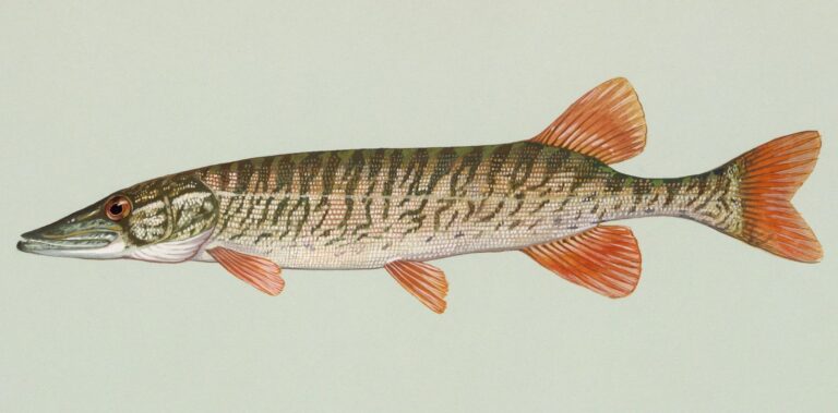
Photo: Duane Raver, Public domain


Photo: USFWS Mountain-Prairie, Public domain

Photo: USFWS Mountain-Prairie, Public domain
Questions folks bring up about Oconee County
How many public landings does SCDNR map in Oconee County?
34 landings and launches, named in the access list above.
Which reservoir or pond in Oconee County is the biggest South Carolina water?
It is Lake Hartwell, 56,000 acres.
Which fish lead SCDNR lists close to Oconee County?
SCDNR access lists name Largemouth Bass on the most lake pages within 50 miles, then Bluegill, Alabama Bass and Channel Catfish.
Where do Oconee County anglers stock up on shrimp and minnows?
There are 10; Black Mountain Trout Farm is one.
In what town does Oconee County keep its courthouse?
It is Walhalla.
What will a year of fishing Oconee County cost?
Plan on $10 (in-state) or $35 (out-of-state) for twelve months of freshwater fishing.
Which counties border Oconee County?
Pickens County, Anderson County and Greenville County lie nearest.
How many crappie may be kept in Oconee County?
Statewide: Crappie: 20 daily, size 8 inches min. A guide row naming a lake can change it.
Under which SCDNR region is Oconee County listed?
SCDNR Region 1, going by the majority of its SCDNR access records.
Which Oconee County waters carry their own guide row?
5 waters with a page here have a guide row of their own, beginning with Chattooga River.
Do team trails fish Oconee County?
19 organizer entries on file; next is CATT SC Upstate Qualifier #1 on Lake Keowee, Nov. 14, 2026.
Which SCDNR record traces to Oconee County water?
Spotted Bass, 8-5 as listed, from Lake Jocassee (2001).
Are Oconee County lakes shared with another state?
All persons holding a valid license from Georgia or South Carolina will be allowed to fish in the waters covered by this agreement.
Hitch the boat for Oconee County
Check a lake's own guide row before keeping fish.