Peconic Bay Fishing
Where to launch, the DEC rules and the guides for Peconic Bay.
 Pick for flounderPiscifun Alloy S inshore spinning reelCheck price at Piscifun
Photo: Leonard J. DeFrancisci, CC BY-SA 3.0
Introducing Peconic Bay
The New York shore of Peconic Bay, a bay, runs through Suffolk County. The DEC tables, records and stocking files here name winter flounder, striped bass, scup, summer flounder, black sea bass and oyster toadfish.
Mapped for it: 48 launches, 4 piers, 30 further shore spots, 0 harbors on GNIS and 0 tributary pages.
USGS GNIS, DEC launch, fishing access and marine access layers, retrieved October 24, 2026.
 For the flounder herePiscifun NautiX saltwater spinning reel14% OFFSale $94.99
Access sites along Peconic Bay
Public launches serving Peconic Bay
- Barker's Island Road End Launchboat launch, parking: very limited
- Birch Creek Road Rampboat launch, parking: very limited
- Bootleggers Alley Rampboat launch, parking: very limited
- Brander Parkway Rampboat launch, parking: very limited
- Bullhead Bay Rampboat launch, parking: very limited
- Cedar Beach Boat Ramphard surface ramp, parking: limited; managed by Municipal
- Cedar Point Lane Rampboat launch, parking: very limited
- Conscience Point Road Rampboat launch, parking: limited
- Corwell Avenue Launchboat launch, parking: very limited
- Daniel Lord Road Rampboat launch, parking: very limited
- Dickerson Drive Rampboat launch, parking: very limited
- East Creek Boat Launch on Peconic Bayhard surface ramp, 45 parking spaces; managed by Municipal
- Forge Pond (Peconic River) access, Suffolk Countyhard surface ramp, 15 parking spaces; managed by DEC
- Gagen's Landing Boat Rampboat launch, parking: very limited
- Hashamomuck Marine Waterway Access Siteboat launch, parking: ample
- Heron Lane Rampboat launch, parking: very limited
- Inlet Road Rampboat launch, parking: very limited
- Little Neck Road Ramp on East Creek, Little Peconic Bayboat launch, parking: very limited
- Maple Lane Rampboat launch, parking: very limited
- Menantic Road Rampboat launch, parking: very limited
- Mill Creek Boat Rampboat launch, parking: very limited
- Minnehaha Boulevard Rampboat launch, parking: very limited
- New Suffolk Boat Ramphard surface ramp, parking: limited; managed by Municipal
- North Brander Parkway Ramp on Shelter Island Soundboat launch, parking: very limited
- North Silver Beach Road Ramp on West Neck Harbor, Shelter Island Soundboat launch, parking: very limited
- Parker's Landing Road Boat Rampboat launch, parking: very limited
- Peconic River (Lower) – Upper Mills access, Suffolk Countyhand launch, 5 parking spaces; managed by Municipal
- Peconic River (Lower) access, Suffolk County (east)hand launch, 5 parking spaces; managed by Municipal
- Peconic River (Lower) access, Suffolk County (west)unpaved trailer launch, 5 parking spaces; managed by DEC
- Peconic River (River Road East) access, Suffolk Countyhand launch, 3 parking spaces; managed by DEC
- Peconic River (River Road West) access, Suffolk Countyhand launch, 3 parking spaces; managed by DEC
- Peconic River (Upper) access, Suffolk County (east)hand launch, 10 parking spaces; managed by DEC
- Peconic River (Upper) access, Suffolk County (east)hand launch, 4 parking spaces; managed by DEC
- Peconic River (Upper) access, Suffolk County (west)hand launch; managed by DEC
- Pine Neck Avenue Rampboat launch, parking: very limited
- Pine Neck Road Rampboat launch, parking: very limited
- Point Road Rampboat launch, parking: limited
- Red Creek Road Rampboat launch, parking: very limited
- Shore Road Rampboat launch, parking: very limited
- Shrubland Road Launch Siteboat launch, parking: very limited
- Simpson Road Rampboat launch, parking: very limited
- Tarkettle Road Rampboat launch, parking: very limited
- Terry Lane Boat Rampboat launch, parking: very limited
- Thompson Road Rampboat launch, parking: very limited
- Village of Sag Harbor Boat Ramp on Sag Harbor Bay, Shelter Island Soundboat launch, parking: very limited
- Wells Road Rampboat launch, parking: very limited
- West Neck Point Road End Launch on Little Sebonac Creek, Great Peconic Bayboat launch, parking: very limited
- West Neck Road Ramp on West Neck Bay, Shelter Island Soundboat launch, parking: very limited
Pier fishing spots around Peconic Bay
- Hashamomuck Marine Waterway Access SiteSouthold, Nys Dec
- Hashamomuck Marine Waterway Access Site fishing pier
- Pine Neck Avenue Ramp fishing pier
- Bullhead Bay Ramp fishing pier
Walk-in fishing along Peconic Bay
- Peconic Bay ParkShore, Laurel
- Veterans ParkShore, Mattituck
- Miamogue Point ParkShore, Jamesport
- East Creek Boat LaunchDock, bank fishing, Jamesport
- South Jamesport BeachShore, Jamesport
- Peconic Riverfront ParkDock, bank fishing, Riverhead
- Wades BeachShore, Shelter Island
- Crescent Beach, Shelter IslandShore, Shelter Island
- Oakhurst Road Beach AccessShore, Hampton Bays
- Sebonanc Inlet Road fishing access, SouthamptonShore, Southampton
- Inlet Road DockDock, bank fishing, Southampton
- East Landing BeachShore, Hampton Bays
- West Landing BeachShore, Hampton Bays
- Cold Spring Road BeachShore, Southampton
- Pine Neck Avenue Ramp fishing access, NoyackDock, bank fishing, Noyack
- Nassau Point BeachShore, Cutchogue
- Bay Avenue Terminus, CutchogueShore, Cutchogue
- Island View Lane Terminus fishing access, GreenportShore, Greenport
- Sigsbee Road Terminus fishing access, MattituckShore, Mattituck
- New Suffolk BeachShore, New Suffolk
- Emerson ParkShore, Southold
- Goose Creek BeachShore, Southold
- Bay Home Road TerminusShore, Southold
- Town Habor Lane Terminus fishing access, SoutholdShore, Southold
- Founders Landing ParkShore, Southold
- Meschutt Beach County ParkJetty, Shore, Hampton Bays
- Indian Island County ParkShore, Riverhead
- Cedar Beach County ParkShore, Southold
- Elizabeth A Morton National Wildlife Refuge fishing access, NoyacShore, Noyac
- Hashamomuck fishing access, Suffolk Countybank fishing
DEC boat launch, fishing access and marine access layers, NYS Parks launches, USGS GNIS, retrieved October 24, 2026.
Where streams and harbors meet Peconic Bay
Coves and bays along Peconic Bay
- Flanders BaySuffolk County
- Great Peconic BaySuffolk County
- Little Peconic BaySuffolk County
- Noyack BaySuffolk County
- Noyack CreekSuffolk County
- Shelter Island SoundSuffolk County
- Southold BaySuffolk County
USGS GNIS names, DEC Great Lakes tributary listing, retrieved October 24, 2026.
Carrying fish home from Peconic Bay
| Species | Daily limit and size | Season |
|---|---|---|
| Winter Flounder | 2; minimum 12" | Apr 1 – May 30 |
| Striped Bass | 1; minimum 28" to 31" (slot) | Apr 15 – Dec 15 |
| Scup (Porgy) | 30; minimum 9.5" from shore; 11" from a vessel | May 1 – Dec 31 |
| Summer Flounder (Fluke) | 3; minimum 19" | May 4 – Aug 1 |
| Summer Flounder (Fluke) | 3; minimum 19.5" | Aug 2 – Oct 15 |
| Black Sea Bass | 3; minimum 16" | May 16 – Aug 31 |
| Black Sea Bass | 6; minimum 16" | Sep 1 – Dec 31 |
| Oyster Toadfish | 3; minimum 10" | Jul 16 – May 14 |
| Tautog (Blackfish) | 2; minimum 16" | Apr 1 – Apr 30 |
| Tautog (Blackfish) | 3; minimum 16" | Oct 11 – Dec 9 |
| Tautog (Blackfish) | 2; minimum 16" | Apr 1 – Apr 30 |
| Tautog (Blackfish) | 4; minimum 16" | Oct 15 – Dec 22 |
| American Eel | 25; minimum 9" | All year |
| Atlantic Cod | 5; minimum 23" | Sep 1 – May 31 |
| Atlantic Menhaden | 100 | All year |
| Bluefish | 5 | All year |
| Cobia | 1; minimum 43" | All year |
| Haddock | No daily limit; minimum 18" | All year |
| Hickory Shad | 5 | All year |
| King Mackerel | 3; minimum 23" | All year |
| Monkfish | No daily limit; minimum 17" (11" tail length) | All year |
| Pollock | No daily limit; minimum 19" | All year |
| Red Drum | Any number under 27" | All year |
| Spanish Mackerel | 15; minimum 14" | All year |
| Weakfish | 1; minimum 16" (10" fillet, 12" dressed) | All year |
| Yellowtail Flounder | No daily limit; minimum 13" | All year |
DEC sets these saltwater seasons for the Marine and Coastal District.
Anglers 16 and older who fish for saltwater species, or for migratory fish of the sea, enroll in the free DEC Recreational Marine Fishing Registry instead of buying a license; freshwater fishing takes the DEC license ($25.00 resident, $50.00 nonresident).
DEC recreational saltwater fishing regulations (finfish limits changed May 12, 2026), retrieved October 24, 2026, figures checked against the DEC pages October 25, 2026. All New York limits.
DEC-licensed guides for Peconic Bay
- Elite Long Island Outfitterfishing guide, Long Island, Amityville
- J & L Guide Servicefishing guide, Brookhaven
- DC Outdoor Adventuresfishing guide, Farmingville
- Montauk Outfitterfishing guide, Montauk
Where to buy bait for Peconic Bay
- New Suffolk Shipyard at Cutchogue Harbormarina, Cutchogue, 1 mile
- Mattituck Creek Waterway Access Sitemarina, Suffolk, 5 miles
- Shinnecock Canal County Marinamarina, Suffolk, 7 miles
- Personal Marine Servicemarina, Suffolk, 7 miles
- Great Peconic Bay Marinamarina, Jamesport, 7 miles
- MNL Marinemarina, Suffolk, 7 miles
- Hampton Watercraft and Marinemarina, Suffolk, 7 miles
- Surfside 3 Modern Yachtsmarina, Suffolk, 7 miles
- Port of Egypt Marinemarina, Southold, 7 miles
- Hashamomuck Pond Waterway Accessmarina, Suffolk, 7 miles
- Spellman's Marinamarina, Suffolk, 7 miles
- Indian Cove Marinamarina, Suffolk, 7 miles
DEC licensed guide list (business name and county), OpenStreetMap and DEC license agent shop listings, retrieved October 24, 2026.
More big water next to Peconic Bay
- Tidal Hudson Rivertidal river
- Long Island Soundsound
- South Shore of Long Islandocean shore and bays
- Gardiners Baybay
- New York Harborharbor
Reels and pliers from Piscifun for Peconic Bay trips


Piscifun and Amazon links are affiliate links; the site earns a commission on qualifying purchases.
Photographs of the species found at Peconic Bay
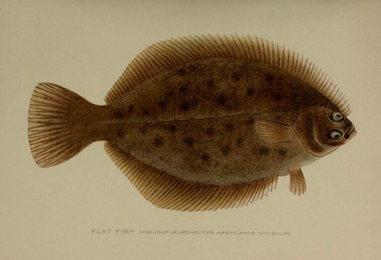
Photo: New York (State). Forest, Fish and Game Commission, Public domain

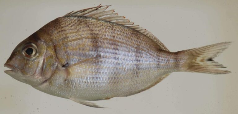
Photo: Smithsonian Environmental Research Center, CC BY 2.0

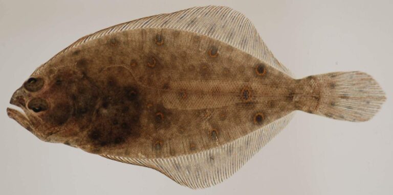
Photo: Smithsonian Environmental Research Center, CC BY 2.0

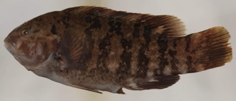
Photo: Smithsonian Environmental Research Center, CC BY 2.0

Peconic Bay in a handful of answers
What does it cost to fish Peconic Bay?
Anglers 16 and older who fish for saltwater species, or for migratory fish of the sea, enroll in the free DEC Recreational Marine Fishing Registry instead of buying a license; freshwater fishing takes the DEC license ($25.00 resident, $50.00 nonresident).
Which launches reach Peconic Bay?
48 launches are listed on this page, among them Peconic River (River Road West) access, Suffolk County, Peconic River (River Road East) access, Suffolk County and Peconic River (Lower) – Upper Mills access, Suffolk County.
What fish swim in Peconic Bay?
Winter flounder, striped bass, scup, summer flounder, black sea bass, oyster toadfish and tautog.
Can I cast from land at Peconic Bay?
4 piers and 30 other shore sites are listed, such as Hashamomuck Marine Waterway Access Site and Hashamomuck Marine Waterway Access Site fishing pier.
Who guides on Peconic Bay?
4 businesss from the DEC licensed guide list are shown, for example Elite Long Island Outfitter.
What is Peconic Bay reading on its gauge now?
No level station is matched to it on this page.
Which New York counties front Peconic Bay?
Suffolk County.
What are the striped bass rules on Peconic Bay?
1; minimum 28" to 31" (slot); Apr 15 – Dec 15.
What are the summer flounder rules on Peconic Bay?
3; minimum 19"; May 4 – Aug 1.
Head out on Peconic Bay this season
Study the DEC rows first, then choose where to launch.