Fishing in Poinsett County, Arkansas
County seat: Harrisburg. Population 22,965 (2020).
- 9lake pages
- 27launches
- 6river pages
 Pick for black bassPiscifun Chaos Pro CNC baitcasting reel25% OFFSale $97.99
Photo of Spring River: Brandonrush, CC0 1.0
Ahead of a first trip around Poinsett County
Home to 22,965 people in 2020, Poinsett County keeps its offices in Harrisburg. Lake Poinsett heads the list of 9 lakes in the county with full pages.
Count 27 boat or paddle launches plus 12 pier or bank sites on the AGFC layers here. Running water with a page includes St. Francis River, Bayou De View and L'Anguille River.
U.S. Census Bureau, 2020 Census counts (TIGERweb) and the 2023 Gazetteer, read November 8, 2026. AGFC access layer (ArcGIS service), read November 8, 2026.
Poinsett County ramps, piers and lakes pinned on one map
AGFC boat-and-kayak and fishing access layers and AGFC fishing-area lake points, checked November 8, 2026.
Lakes spread across Poinsett County
| Lake | Size | Ramps | Kind | AGFC target fish |
|---|---|---|---|---|
| Lake Poinsett | 445 acres | 3 | lake | black bass, bream, catfish |
| Lake Hogue | about 237 acres of mapped outline | 0 | lake | black bass, bream, catfish |
| Hogue Lake Lower | about 159 acres of mapped outline | 1 | lake | black bass, bream, catfish |
| Ditch 60 | about 139 acres of mapped outline | 1 | lake | black bass, bream, catfish |
| Ditch 59 | about 32 acres of mapped outline | 1 | lake | black bass, bream, catfish |
| St. Francis Sunken Lands Ditch | about 32 acres of mapped outline | 1 | lake | alligator gar, black bass, bream |
| Hogue Lake Upper | about 29 acres of mapped outline | 1 | lake | black bass, bream, catfish |
| Ditch 105 | not stated | 1 | lake | black bass, bream, catfish |
| Ditch 61 | not stated | 1 | lake | black bass, bream, catfish |
Acreage and depth as AGFC states them in its description of this water (AGFC page), read November 8, 2026. Sizes AGFC does not state print as mapped outline area. Target fish as AGFC lists them.
 For the black bass herePiscifun AlinoX 300 low profile baitcaster34% OFFSale $104.99
Counting AGFC target fish on lakes near Poinsett County
Each bar counts lake pages within 50 miles of Harrisburg where AGFC lists the fish to target; catfish comes up most.
AGFC public fishing area target species, counted per lake page within 50 miles; a listing, not a catch survey.
Named AGFC and NHD lakes of Poinsett County still awaiting pages
Another 3 named waters in Poinsett County stay on this list without a full page.
| Water | Size | Kind | Nearest town |
|---|---|---|---|
| Truman City Pond | about 4 acres of mapped outline | mapped pond | Trumann |
| Hatchie Coon Lake | not stated | lake | Rivervale |
| Lake Poinsett State Park | not stated | lake | Harrisburg |
Outline area from the AGFC lake or pond outline (GIS polygon area, not an AGFC surface-acre figure), read November 8, 2026. AGFC public fishing areas map (agfc.com), read November 8, 2026.
Rivers to wade in Poinsett County
- St. Francis RiverAGFC water trail, 22 AGFC accesses
- Bayou De View4 AGFC accesses, 1 USGS gauge
- L'Anguille River2 AGFC accesses, 3 USGS gauges
- Little River (Mississippi County)1 AGFC access
- Marked Tree Floodway Ditch 611 AGFC access
- Right Hand Chute Little River1 AGFC access
Creeks and bayous of Poinsett County listed here only (2)
- Left Hand Chute of Little Riverstream
- Old Channel Cache Riverstream
Flow gauges around Poinsett County
USGS has no current reading for these gauges.
AGFC public fishing areas map (agfc.com), read November 8, 2026. USGS Water Data for the Nation, live through the site, retrieved on page view.
Trailer ramps around Poinsett County
- Combine Field Access on St. Francis RiverSt. Francis River, boat ramp, gravel surface
- Decklemen Boating Access on Lake PoinsettLake Poinsett, boat ramp, concrete surface
- Don Lovell Access #2 on St. Francis RiverSt. Francis River, boat ramp, concrete surface
- Don Lovell Boating Access on St. Francis RiverSt. Francis River, boat ramp, concrete surface
- Lake Poinsett Dam Boating AccessLake Poinsett, boat ramp, concrete plank surface, mobility-impaired
- Lower Lake Hogue Boat Ramp on Hogue Lake LowerHogue Lake Lower, boat ramp, concrete surface
- Marked Tree Access on St. Francis RiverSt. Francis River, boat ramp, concrete surface
- North Oliver Access on Bayou De ViewBayou De View, boat ramp, dirt surface, camping
- Oak Donnick Access on St. Francis RiverSt. Francis River, boat ramp, concrete surface
- Payneway Access on St. Francis RiverSt. Francis River, boat ramp, concrete surface
- Poinsett Lake State Park Boat RampLake Poinsett, boat ramp, concrete surface
- Rainbow Access on Ditch 105Ditch 105, boat ramp, concrete surface
- Rivervale Access on Little River (Mississippi County)Little River (Mississippi County), boat ramp, concrete plank surface, camping, picnic tables, recreational area
- Singer East AccessMarked Tree Floodway Ditch 61, boat ramp, concrete surface
- Singer West AccessMarked Tree Floodway Ditch 61, boat ramp, concrete surface
- St. Francis Sunken Lands Ditch 61 Parking Area Boat RampDitch 61, boat ramp
- St. Francis Sunken Lands Don Lovell Access #1St. Francis River, boat ramp
- St. Francis Sunken Lands Manis Field Parking Area Boat Ramp on Ditch 59Ditch 59, boat ramp
- St. Francis Sunken Lands Rainbow Access Parking AreaSt. Francis River, boat ramp
- St. Francis Sunken Lands Rivervale Boat Ramp on Right Hand Chute Little RiverRight Hand Chute Little River, boat ramp
- St. Francis Sunken Lands Snowden Parking Area Boat Ramp on Ditch 60Ditch 60, boat ramp
- St. Francis Sunken Lands South Pump Access on St. Francis Sunken Lands DitchSt. Francis Sunken Lands Ditch, boat ramp
- St. Francis Sunken Lands Stephen's Landing Parking AreaSt. Francis River, boat ramp
- Stephen's Landing Access on St. Francis RiverSt. Francis River, boat ramp, concrete plank surface
- Upper Lake Hogue Boat Ramp on Hogue Lake UpperHogue Lake Upper, boat ramp, concrete surface
- Whitehall WMA Access on L'Anguille RiverL'Anguille River, boat ramp, dirt surface
- Thompson Tract Boat Rampwater not named, boat ramp, gravel surface
Fishing piers AGFC maps in Poinsett County
- Auxillary Spillway Bank Fishing Area on Lake PoinsettLake Poinsett, bank fishing
- Dam Access Bank Fishing Area on Lake PoinsettLake Poinsett, bank fishing, mobility-impaired
- Decklemen Bank Fishing Area on Lake PoinsettLake Poinsett, bank fishing
- Lake Front Lane Bank Fishing Area on Lake PoinsettLake Poinsett, bank fishing
- Lake Poinsett State Park Bank Fishing Area #1Lake Poinsett, bank fishing
- Lake Poinsett State Park Bank Fishing Area #2Lake Poinsett, bank fishing
- Lake Poinsett State Park Bank Fishing Area #3Lake Poinsett, bank fishing
- Lake Poinsett State Park Bank Fishing Area #4Lake Poinsett, bank fishing
- Lake Poinsett State ParkLake Poinsett State Park, fishing area
- North Oliver Camping Area Fishing Access on Lake HogueLake Hogue, fishing area, camping
- Public fishing access on Hogue Lake LowerHogue Lake Lower, fishing pier
- Public fishing access on Lake PoinsettLake Poinsett, fishing pier, mobility-impaired
AGFC access layer (ArcGIS service), read November 8, 2026. Lanes, fees and hours are not fields in the AGFC layers.
Statewide daily limits for Poinsett County water
Start from these statewide limits in Poinsett County; a water-specific exception replaces them where one is written. Expect to pay $10.50 (Arkansas resident) or $60 (out of state) for a year of fishing.
| Species | Statewide rule as printed | Code |
|---|---|---|
| Alligator Gar | daily limit of 1 with 36-inch maximum length. | N1.01(C) |
| American Eel | daily limit of 2 fish with no length restrictions. | N1.01(D) |
| Black Bass (Largemouth, Spotted, And Smallmouth) | daily limit of 10 black bass (all species combined) with no length restrictions. Reservoir Smallmouth Bass, daily limit of 6, 12-inch minimum; Flowing Waters Smallmouth Bass, daily limit of 2, 12-inch minimum. | N1.01(E) |
| Bream | Daily limit is 50 fish over 4 inches, no limit on bream 4 inches or shorter. | N1.01(F) |
| Catfish (Except Bullhead) | daily limit of 10 catfish (all species combined) with no length restrictions. | N1.01(G) |
| Crappie | daily limit of 30 crappie (all species combined) with no length restrictions. | N1.01(H) |
| Paddlefish | daily limit of 2 Paddlefish with no length restrictions. | N1.01(I) |
| Rock Bass | daily limit of 10 Rock Bass with no length restrictions. | N1.01(J) |
| Sauger | daily limit of 6 Sauger with no length restrictions. | N1.01(K) |
| Saugeye | daily limit of 6 Saugeye with no length restrictions. | N1.01(L) |
Exceptions AGFC lists in Poinsett County
- Lake HogueCrappie: No daily limit.
- Lake PoinsettBlack Bass (Largemouth, Spotted, And Smallmouth): Only 1 Largemouth Bass longer than 16 inches.
Every Arkansas water-specific limit
Code 26.08 waters inside Poinsett County
Trotlines, jugs and limb lines are out on Upper Lake Hogue: Code 26.08 names them for Poinsett County.
Rod-or-pole and border water rules
AGFC Code of Regulations (regulation library), read November 8, 2026. Fishing license prices as printed on the AGFC license descriptions and fees page (agfc.com), matching Code Addendum D1.01, read November 8, 2026.
Record catches pulled from water near Poinsett County
Record fish came from these waters near Poinsett County, all within 70 miles.
| Species | Weight | Division | Water | Date |
|---|---|---|---|---|
| Saugeye | 9 lbs., 0 oz. | rod and reel | Lake Frierson | Jan. 30, 2012 |
| Largemouth Bass | 16 lbs., 4 oz. | rod and reel | Mallard Lake | March 2, 1976 |
| Shadow Bass | 1 lb., 12 oz. | rod and reel | Spring River | July 5, 1999 |
| American Eel | 5 lbs., 4 oz. | rod and reel | Spring River | July 12, 2015 |
Arkansas state record fish as listed by AGFC (record list), read November 8, 2026.
Gear stores in Poinsett County
Poinsett County bait counters
- Dewailly's Fishing & Huntingbait and tackle shop, Lepanto
Yellow Pages and tourism guide listings (city of business), read November 8, 2026.
Not far from Poinsett County
Town pages inside Poinsett County
- Trumannpop. 7,399
- Marked Treepop. 2,286
- Harrisburgpop. 2,212
- Lepantopop. 1,732
Adjacent to Poinsett County
- Craighead County18 miles north
- Cross County20 miles south
- Jackson County31 miles west
- Crittenden County33 miles southeast
Piscifun tackle staged for a morning at Poinsett County


Piscifun and Amazon links are affiliate links; the site earns a commission on qualifying purchases.
Telling the Poinsett County fish apart at a glance

Photo: Deskana, CC BY-SA 3.0


Photo: USFWS Fish and Aquatic Conservation, Public domain
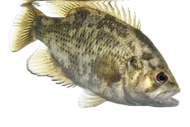
Photo: USFWS Mountain-Prairie, Public domain
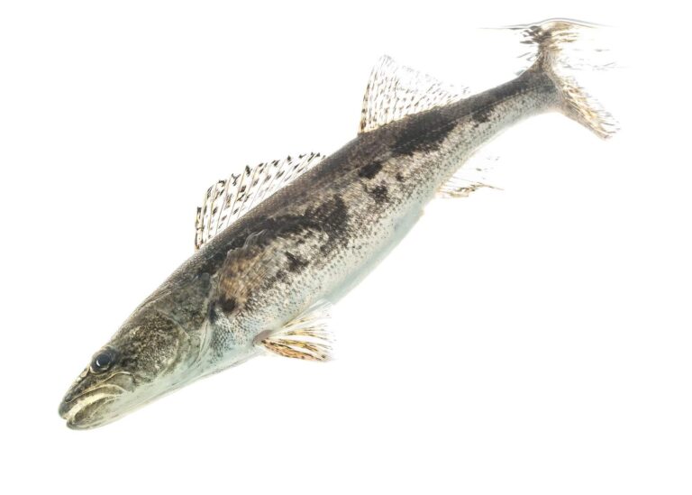
Photo: USFWS Mountain-Prairie, CC BY 2.0
Fishing across Poinsett County: the common questions
How many ramps serve Poinsett County anglers?
There are 27 launches in the AGFC layers.
Which lake covers the most water in Poinsett County?
Lake Poinsett (445 acres).
What do anglers target around Poinsett County?
AGFC lists catfish on the most lake pages within 50 miles, then bream, black bass and crappie.
Where can I pick up crickets and minnows in Poinsett County?
Try Dewailly's Fishing & Hunting; there are 1 in all.
Which Arkansas town hosts the Poinsett County courthouse?
Harrisburg.
What AGFC license do Poinsett County anglers carry?
The AGFC fee table lists $10.50 for the resident license and $60 for the nonresident annual.
Which counties neighbour Poinsett County?
Start with Craighead County, Cross County and Jackson County.
What is the crappie limit across Poinsett County?
Statewide: daily limit of 30 crappie (all species combined) with no length restrictions. Waters with their own Code line differ.
Which Poinsett County lakes have their own rules?
2 waters with a page here carry their own Code line, starting with Lake Hogue.
Plan a fishing weekend in Poinsett County
River pages list AGFC accesses and USGS flow.