Fishing in Baxter County, Arkansas
County seat: Mountain Home. Population 41,627 (2020).
- 4lake pages
- 42launches
- 3river pages
 Pick for troutPiscifun Carbon X ultralight spinning reel28% OFFSale $57.99
Photo of Bull Shoals Lake: Semipaw, CC BY 3.0
Fishing Baxter County at a glance
The 2020 count put Baxter County at 41,627 residents, with Mountain Home as its seat. Of 4 lakes in the county with a page, Bull Shoals Lake covers the most water. Norfork Tailwater and Bull Shoals Tailwater gives the county a trout fishery fed by the dam.
The access layers show 42 boat or paddle launches and 14 pier or bank sites for the county. River anglers can start with White River, North Fork River (North Fork of the White River) and Dry Run Creek.
U.S. Census Bureau, 2020 Census counts (TIGERweb) and the 2023 Gazetteer, read November 8, 2026. AGFC access layer (ArcGIS service), read November 8, 2026.
 For the trout herePiscifun Carbon XT ultralight spinning reel25% OFFSale $59.99
Where the AGFC points fall across Baxter County
AGFC boat-and-kayak and fishing access layers and AGFC fishing-area lake points, checked November 8, 2026.
Choosing a lake in Baxter County
| Lake | Size | Ramps | Kind | AGFC target fish |
|---|---|---|---|---|
| Bull Shoals Lake | 48,225 acres | 22 | Corps lake | black bass, bream, catfish |
| Norfork Lake | about 18,811 acres of mapped outline | 24 | Corps lake | black bass, bream, crappie |
| McCabe Park | about 3 acres of mapped outline | 0 | mapped pond | black bass, bream, catfish |
| Amon’s Lake | about 1 acres of mapped outline | 1 | mapped pond | bream, catfish, trout (seasonal stocking) |
Acreage and depth as AGFC states them in its description of this water (AGFC page), read November 8, 2026. Sizes AGFC does not state print as mapped outline area. Target fish as AGFC lists them.
Target species on lake pages around Baxter County
Out to 50 miles from Mountain Home, AGFC names bream on more lake pages than any other fish.
AGFC public fishing area target species, counted per lake page within 50 miles; a listing, not a catch survey.
Lakes in Baxter County waiting on more AGFC facts
1 more lakes in Baxter County have a name on the maps but few published facts.
| Water | Size | Kind | Nearest town |
|---|---|---|---|
| Briarcliff Lake | about 2 acres of mapped outline | lake | Briarcliff |
Outline area from the AGFC lake or pond outline (GIS polygon area, not an AGFC surface-acre figure), read November 8, 2026. AGFC public fishing areas map (agfc.com), read November 8, 2026.
Creeks running through Baxter County
- White RiverAGFC trout water, 53 AGFC accesses, 15 USGS gauges
- North Fork River (North Fork of the White River)AGFC trout water, 2 AGFC accesses, 1 USGS gauge
- Dry Run Creek3 AGFC accesses
Unpaged streams across Baxter County (1)
- Bennetts River1 USGS gauge
River stages across Baxter County
| USGS gauge | Latest reading | Time (ET) |
|---|---|---|
| White River Near Norfork, Ar | 1,240 cfs, 4.17 ft gage height | Nov 12 5:30 pm |
US Geological Survey provisional data, retrieved Nov 12, 2026 6:33 pm ET. Provisional readings can be revised.
AGFC public fishing areas map (agfc.com), read November 8, 2026. USGS Water Data for the Nation, live through the site, retrieved on page view.
Tailwater trout fishing reached from Baxter County
- Norfork TailwaterNorth Fork River (North Fork of the White River)
- Bull Shoals TailwaterWhite River
AGFC public fishing areas map (agfc.com), read November 8, 2026. AGFC trout waters page, read November 8, 2026.
Public ramps in Baxter County
- Amon's Lake Boat RampAmon’s Lake, boat ramp, concrete surface, fishing pier, picnic tables, recreational area
- Buffalo City Boat Ramp on White RiverWhite River, boat ramp, concrete surface, restrooms
- Buzzard Roost Boat Ramp on Norfork LakeNorfork Lake, boat ramp, concrete surface, camping, picnic tables, recreational area
- Calamity Beach Access Dock on Norfork LakeNorfork Lake, boat ramp, camping, picnic tables, recreational area
- Calamity Beach Boat Ramp on Norfork LakeNorfork Lake, boat ramp, concrete surface, camping, picnic tables, recreational area
- Cartney Boat Ramp on White RiverWhite River, boat ramp, concrete surface
- Cotter Boat Ramp on White RiverWhite River, boat ramp, concrete surface, picnic tables, recreational area, restrooms
- County Road 15 Boat Ramp on Bull Shoals LakeBull Shoals Lake, boat ramp, concrete surface, picnic tables, recreational area, restrooms
- Cranfield Boat Ramp on Norfork LakeNorfork Lake, boat ramp, concrete surface, camping, fishing pier, mobility-impaired
- Dam Quarry Campground Boat Ramp on North Fork River (North Fork of the White River)North Fork River (North Fork of the White River), boat ramp, concrete surface, camping, picnic tables, recreational area
- Gaston's Resort Boat Ramp on White RiverWhite River, boat ramp, concrete plank surface
- Howard Creek Boat Ramp on Bull Shoals LakeBull Shoals Lake, boat ramp, concrete surface, picnic tables, recreational area, restrooms
- Jim Griffin Boat Ramp on White RiverWhite River, boat ramp, concrete surface, fishing pier, restrooms
- Norfork #1 Boat Ramp on White RiverWhite River, boat ramp, concrete surface, restrooms
- Norfork #2 Boat Ramp on White RiverWhite River, boat ramp, concrete surface, restrooms
- Norkfork Dam Parking Area Boat Ramp on Dry Run CreekDry Run Creek, boat ramp
- Panther Bay #1 Boat Ramp on Norfork LakeNorfork Lake, boat ramp, concrete surface, camping, picnic tables, recreational area
- Panther Bay #2 Boat Ramp on Norfork LakeNorfork Lake, boat ramp, concrete surface, camping, picnic tables, recreational area
- Panther Bay Boat Ramp on Norfork LakeNorfork Lake, boat ramp, concrete surface, camping, picnic tables, recreational area
- Red's Landing on White RiverWhite River, boat ramp, concrete surface, restrooms
- Rim Shoals Boat RampWhite River Bull Shoals Tailwater, boat ramp, concrete surface, fishing pier, restrooms
- Shipp's Ferry Boat Ramp on White RiverWhite River, boat ramp, concrete surface, restrooms
- Sneed Creek Boat Ramp on White RiverWhite River, boat ramp, concrete surface
- Wildcat Shoals Boat Ramp on White RiverWhite River, boat ramp, concrete surface, restrooms
- Bidwell Point Boat Ramp on Norfork LakeNorfork Lake, boat ramp, concrete surface
- Gamaliel Boat Ramp on Norfork LakeNorfork Lake, boat ramp, concrete surface
- George's Cove Boat Ramp on Norfork LakeNorfork Lake, boat ramp, concrete surface
- Hand Cove Boat Ramp on Norfork LakeNorfork Lake, boat ramp, concrete surface
- Henderson Boat Ramp on Norfork LakeNorfork Lake, boat ramp, concrete surface
- Henderson High Water Boat Ramp on Norfork LakeNorfork Lake, boat ramp, concrete surface
- Howard Cove Boat Ramp on Norfork LakeNorfork Lake, boat ramp, concrete surface
- Jordan Boat Ramp on Norfork LakeNorfork Lake, boat ramp, concrete surface
- Lakeview Boat Ramp on Bull Shoals LakeBull Shoals Lake, boat ramp, concrete surface
- Pigeon Creek #1 Boat Ramp on Norfork LakeNorfork Lake, boat ramp, concrete surface
- Pigeon Creek #2 Boat Ramp on Norfork LakeNorfork Lake, boat ramp, concrete plank surface
- Public boat ramp on Norfork Lake (north)Norfork Lake, boat ramp, concrete surface, camping, picnic tables, recreational area
- Public boat ramp on Norfork Lake (south)Norfork Lake, boat ramp, concrete surface, camping, picnic tables, recreational area
- Public boat ramp on White River (east), Baxter CountyWhite River, boat ramp, concrete plank surface, camping, picnic tables, recreational area
- Robinson Point Boat Ramp on Norfork LakeNorfork Lake, boat ramp, concrete surface
- Talbert Point Boat Ramp on Norfork LakeNorfork Lake, boat ramp, concrete surface
- Tracy Ferry Boat Ramp on Norfork LakeNorfork Lake, boat ramp, concrete surface
- Woods Point Boat Ramp on Norfork LakeNorfork Lake, boat ramp, concrete surface
Where to fish from the bank in Baxter County
- Quarry Park Access on Dry Run CreekDry Run Creek, bank fishing, fishing pier, mobility-impaired
- Bronie Yurkonis Walk-In AccessWhite River Bull Shoals Tailwater, bank fishing
- Cartney Walk-In Access (east)White River Bull Shoals Tailwater, walk-in access
- Cartney Walk-In Access (west)White River Bull Shoals Tailwater, bank fishing
- Cotter Walk-In Access (east)White River Bull Shoals Tailwater, walk-in access
- Cotter Walk-In Access (west)water not named, walk-in access
- McCabe ParkMcCabe Park, fishing area
- Public fishing access on Amon’s LakeAmon’s Lake, fishing pier, picnic tables, recreational area
- Public fishing access on Amon’s LakeAmon’s Lake, fishing pier, picnic tables, recreational area
- Public fishing access on Amon’s LakeAmon’s Lake, fishing pier, picnic tables, recreational area
- Public fishing access on Dry Run CreekDry Run Creek, fishing pier, mobility-impaired
- Public fishing access on Dry Run CreekDry Run Creek, walk-in access, fishing pier, mobility-impaired
- Public fishing access on North Fork River (North Fork of the White River)North Fork River (North Fork of the White River), fishing pier, mobility-impaired, restrooms
- Rim Shoals Fishing AccessWhite River Bull Shoals Tailwater, walk-in access, restrooms
AGFC access layer (ArcGIS service), read November 8, 2026. Lanes, fees and hours are not fields in the AGFC layers.
Reservoir levels across Baxter County
Bull Shoals Lake
USACE Little Rock District Bull Shoals Dam reading for Bull Shoals Lake, November 8, 2026.
USACE Little Rock District via USACE Access to Water (location page), latest values at retrieval November 8, 2026. Provisional.
Norfork Lake
USACE Little Rock District Norfork Dam reading for Norfork Lake, November 8, 2026.
USACE Little Rock District via USACE Access to Water (location page), latest values at retrieval November 8, 2026. Provisional.
What Baxter County anglers may keep
For most Baxter County water the statewide Code limits below are the ones to follow. A resident angler spends $10.50 and a nonresident $60 on the yearly AGFC license.
| Species | Statewide rule as printed | Code |
|---|---|---|
| Alligator Gar | daily limit of 1 with 36-inch maximum length. | N1.01(C) |
| American Eel | daily limit of 2 fish with no length restrictions. | N1.01(D) |
| Black Bass (Largemouth, Spotted, And Smallmouth) | daily limit of 10 black bass (all species combined) with no length restrictions. Reservoir Smallmouth Bass, daily limit of 6, 12-inch minimum; Flowing Waters Smallmouth Bass, daily limit of 2, 12-inch minimum. | N1.01(E) |
| Bream | Daily limit is 50 fish over 4 inches, no limit on bream 4 inches or shorter. | N1.01(F) |
| Catfish (Except Bullhead) | daily limit of 10 catfish (all species combined) with no length restrictions. | N1.01(G) |
| Crappie | daily limit of 30 crappie (all species combined) with no length restrictions. | N1.01(H) |
| Paddlefish | daily limit of 2 Paddlefish with no length restrictions. | N1.01(I) |
| Rock Bass | daily limit of 10 Rock Bass with no length restrictions. | N1.01(J) |
| Sauger | daily limit of 6 Sauger with no length restrictions. | N1.01(K) |
| Saugeye | daily limit of 6 Saugeye with no length restrictions. | N1.01(L) |
Water-specific limits across Baxter County
- Bull Shoals LakeBlack Bass (Largemouth, Spotted, And Smallmouth): Daily limit of 6, Largemouth Bass and Smallmouth Bass 15-inch minimum and Spotted Bass 12-inch minimum.
- Norfork LakeBlack Bass (Largemouth, Spotted, And Smallmouth): Daily limit of 6, Largemouth Bass and Smallmouth Bass 13-inch minimum.
- White RiverBlack Bass (Largemouth, Spotted, And Smallmouth): Daily limit of 1 Smallmouth Bass 15-inch minimum.
Every Arkansas water-specific limit
AGFC Code of Regulations (regulation library), read November 8, 2026. Fishing license prices as printed on the AGFC license descriptions and fees page (agfc.com), matching Code Addendum D1.01, read November 8, 2026.
Arkansas record list entries close to Baxter County
| Species | Weight | Division | Water | Date |
|---|---|---|---|---|
| Ozark Bass | 1 lb., 1 oz. | rod and reel | Norfork Lake | May 12, 2014 |
| Rock Bass | 1 lb., 8 oz. | rod and reel | Norfork Lake | Aug. 2, 1982 |
| Smallmouth Bass | 7 lbs., 5 oz. | rod and reel | Bull Shoals Lake | April 1, 1969 |
| Spotted Bass | 7 lbs., 15 oz. | rod and reel | Bull Shoals Lake | March 26, 1983 |
| Gizzard Shad | 2 lbs., 14 oz. | rod and reel | White River | May 9, 1992 |
| White Sucker | 1 lb., 14 oz. | rod and reel | White River | June 16, 2025 |
| Brook Trout | 5 lbs., 0 oz. | rod and reel | North Fork River (North Fork of the White River) | June 3, 2002 |
| Cutthroat Trout | 10 lbs., 2 oz. | rod and reel | North Fork River (North Fork of the White River) | Sept. 29, 2018 |
Arkansas state record fish as listed by AGFC (record list), read November 8, 2026.
Organizer events held in Baxter County
The calendar holds 17 entries on Baxter County water, with 7 to come.
| Date | Event | Water | Organizer |
|---|---|---|---|
| Feb. 27, 2027 | BULL SHOALS | Bull Shoals Lake | Fishers of Men National Team Trail |
| March 6, 2027 | BULL SHOALS (open) | Bull Shoals Lake | Fishers of Men National Team Trail |
| March 20, 2027 | Norfork | Norfork Lake | Fishers of Men National Team Trail |
| April 11, 2027 | April 11 – Bull Shoals Lake, Harrison, Ark. | Bull Shoals Lake | B.A.S.S. |
| April 15, 2027 | Stop 2: Norfork Lake, Arkansas | Norfork Lake | National Professional Fishing League |
| May 15, 2027 | BULL SHOALS | Bull Shoals Lake | Fishers of Men National Team Trail |
| May 29, 2027 | BULL SHOALS (open) | Bull Shoals Lake | Fishers of Men National Team Trail |
| June 6, 2026 | Fishers of Men Arkansas Northwest Classic, Bull Shoals Lake 2026-06 | Bull Shoals Lake | Fishers of Men National Team Trail |
| May 2, 2026 | Fishers of Men Arkansas Northwest Classic, Norfork Lake 2026-05 | Norfork Lake | Fishers of Men National Team Trail |
| March 14, 2026 | Fishers of Men Arkansas Northwest Classic, Bull Shoals Lake 2026-03 | Bull Shoals Lake | Fishers of Men National Team Trail |
| June 7, 2025 | Fishers of Men Arkansas Northwest Classic, Bull Shoals Lake 2025-06 | Bull Shoals Lake | Fishers of Men National Team Trail |
| April 19, 2025 | Fishers of Men Arkansas Central Classic, Bull Shoals Lake 2025-04 | Bull Shoals Lake | Fishers of Men National Team Trail |
Organizer schedule and results pages, checked November 2026.
Shops and guides in Baxter County
Stores selling tackle in Baxter County
- Bubba's Bait & Tackle Shopbait and tackle shop, Mountain Home
- Dally's Ozark Fly Fisherfly shop, Cotter
- Denali Fishing Tacklebait and tackle shop, Mountain Home
- Gerry's Qwik Stop & Tacklebait and tackle shop, Mountain Home
- Holiday Shores Resortbait and tackle shop, Midway
- Jewel Baitbait and tackle shop, Midway
- Nabatak Incbait and tackle shop, Midway
- Red's Bait & Tacklebait and tackle shop, Lakeview
- Rock Springs Tackle, 315 E 9th Stbait and tackle shop, Mountain Home
- Schneider's Rod Shopbait and tackle shop, Mountain Home
- Two Rivers Fly Shopfly shop, Norfork
- Wapsi Flyfly shop, Mountain Home
- 101 Marinamarina, Gamaliel
- Buzzard Roost Harbormarina, Mountain Home
- Cranfield Marinamarina, Mountain Home
- Jordan Marinamarina, Calico Rock
- Lake Norfork Marinamarina, Henderson
- Lakeview Cove Marinamarina, Lakeview
- Norfork Trout Dockmarina, Norfork
- Panther Bay Marina Incmarina, Mountain Home
- Quarry Marinamarina, Salesville
- Tracy Ferry Marinamarina, Mountain Home
Northeast Arkansas tackle shops
Guides based around Baxter County
- Blaine's Trout Guide Servicefishing guide, Cotter, (512) 694-2727
- Cotter Trout Dockfishing guide, Cotter, (870) 435-6525
- Cox's Guide Servicefishing guide, Lakeview, (870) 706-1648
- Misty Mornings Arkansasfishing guide, Norfork, (870) 405-2620
- Ozark outdoors unlimitedfishing guide, Norfork, (870) 373-0710
- Tall pine resortfishing guide, Norfork, (870) 499-7574
- The Fisherman's Lodgefishing guide, Cotter, (870) 449-5673
- Tolliver's Trout Fishingfishing guide, Cotter, (870) 435-2966
- White Buffalo Resortfishing guide, Mountain Home, (870) 425-8555
Yellow Pages and tourism guide listings (city of business), read November 8, 2026.
Around the Baxter County area
Bases for a trip in Baxter County
- Mountain Homepop. 12,825
- Gassvillepop. 2,171
Counties beside Baxter County
- Marion County19 miles west
- Izard County27 miles southeast
- Fulton County29 miles east
- Stone County31 miles south
What Piscifun sells that suits a trip to Baxter County


Piscifun and Amazon links are affiliate links; the site earns a commission on qualifying purchases.
Visual guide to fish swimming at Baxter County
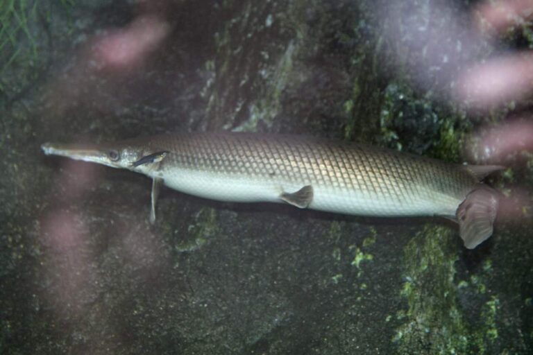
Photo: Cliff, CC BY 2.0


Photo: USFWS Fish and Aquatic Conservation, Public domain

Photo: USFWS Mountain-Prairie, Public domain
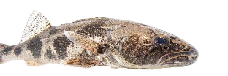
Photo: USFWS Mountain-Prairie, Public domain
What Arkansas anglers ask about Baxter County water
Can I put a johnboat in somewhere in Baxter County?
42 launches on the AGFC layers, with directions links above.
Which Baxter County lake tops the size list?
That is Bull Shoals Lake, 48,225 acres.
Which fish lead AGFC lists near Baxter County?
AGFC lists bream on the most lake pages within 50 miles, then black bass, catfish and crappie.
Does Baxter County have a bait and tackle counter?
22, beginning with Bubba's Bait & Tackle Shop.
Which Arkansas town is seat of Baxter County?
The seat is Mountain Home.
What will a license cost me in Baxter County?
AGFC sells the Resident Fisheries Conservation License for $10.50; a visitor buys the nonresident annual at $60.
Which other Arkansas county pages lie near Baxter County?
Closest by centre point: Marion County, Izard County and Fulton County.
Is there a crappie limit in Baxter County?
Statewide: daily limit of 30 crappie (all species combined) with no length restrictions. Waters with their own Code line differ.
Where do limits change in Baxter County?
3 waters with a page here carry their own Code line, starting with Bull Shoals Lake.
Is an Arkansas tournament coming up in Baxter County?
17 organizer entries on file; next is BULL SHOALS on Bull Shoals Lake, Feb. 27, 2027.
Has Baxter County produced a record fish?
Ozark Bass, 1 lb., 1 oz. (rod and reel), from Norfork Lake.
Can I fish a trout tailwater in Baxter County?
Norfork Tailwater and Bull Shoals Tailwater, with its own trout rules and permit. Keeping trout, or fishing the tailwaters and Spring River reach listed in Code 27.01, adds a trout permit ($10 resident, $20 nonresident).
Pick an AGFC lake or river in Baxter County
Each AGFC launch page opens with a map link for directions.