Fishing in Chesterfield County, South Carolina
County seat: Chesterfield. Population 43,273 (2020). SCDNR Region 2.
- 2lake pages
- 6landings
- 1river pages
 Pick for bluegillPiscifun Carbon X ultralight spinning reel28% OFFSale $57.99
Photo of Wateree River: daveynin, CC BY 2.0
The fishing makeup of Chesterfield County
Chesterfield is where Chesterfield County keeps its seat, in a county of 43,273 at the last census. By SCDNR access records, the county falls mostly in SCDNR Region 2. Sorted by size, Lake Juniper heads the county's 2 lakes with pages.
Within the county line SCDNR places 6 landings and paddle launches and 37 piers and bank sites. Paddle or wade Great Pee Dee River, each with a page.
U.S. Census Bureau, 2020 Census counts (TIGERweb) and the 2023 Gazetteer, read November 9, 2026. SCDNR South Carolina Public Water Access layer (ArcGIS service, the data behind the SCDNR fishing access map), read November 9, 2026.
SCDNR access pins scattered over Chesterfield County
SCDNR Public Water Access layer and lake points, checked November 9, 2026.
Which Chesterfield County lakes have full write-ups
| Lake | Size | Landings | Kind | SCDNR species list |
|---|---|---|---|---|
| Lake Juniper | not printed | 1 | named at an SCDNR access | Largemouth Bass, Bluegill, Redear Sunfish |
| Mays Lake | not printed | 1 | named at an SCDNR access | Largemouth Bass, Bluegill, Redear Sunfish |
From Chesterfield, these lakes beyond the Chesterfield County boundary are the nearest with pages.
| Lake | From Chesterfield | Size | Landings | Kind | SCDNR species list |
|---|---|---|---|---|---|
| Lake Paul Wallace | 24 miles east | 300 acres | 3 | SCDNR state lake | Largemouth Bass, Bluegill, Redear Sunfish |
| Sunrise Lake | 35 miles west | 25 acres | 1 | SCDNR state lake | Largemouth Bass, Bluegill, Redear Sunfish |
| Dargan's Pond | 36 miles southeast | 50 acres | 0 | SCDNR state lake | none on SCDNR lists |
| Lancaster Reservoir | 38 miles west | 60 acres | 1 | SCDNR state lake | Largemouth Bass, Bluegill, Redear Sunfish |
| Lake Ashwood | 46 miles south | 75 acres | 0 | SCDNR state lake | Largemouth Bass, Bluegill, Redear Sunfish |
| Fishing Creek Reservoir | 46 miles west | 3,431 acres | 2 | major reservoir | Largemouth Bass, Bluegill, Redear Sunfish |
Surface acres and depth as SCDNR prints them on its page for this lake, read November 9, 2026. Sizes SCDNR does not print show as mapped outline area. Species as SCDNR lists them at its access points.
 For the bluegill herePiscifun Carbon XT ultralight spinning reel25% OFFSale $59.99
Counting SCDNR species entries around Chesterfield County
Bars show how many lakes within 50 miles of Chesterfield list each fish; Bluegill tops the count.
SCDNR Public Water Access species lists, counted per lake page within 50 miles; an occurrence list, not a catch survey.
More Chesterfield County lakes known by name only
The SCDNR layers carry 26 more named ponds, pools and lakes in Chesterfield County.
| Water | Size | Kind |
|---|---|---|
| Lake Robinson (Chesterfield County) | about 2,058 acres of mapped outline | mapped lake |
| Brown Springs Pond | not printed | named at an SCDNR access |
| Campbells Lake | not printed | named at an SCDNR access |
| Flory Pond | not printed | named at an SCDNR access |
| Goose Pond | not printed | named at an SCDNR access |
| Griggs Pond | not printed | named at an SCDNR access |
| Honker Lake | not printed | named at an SCDNR access |
| Lake 12 | not printed | WMA impoundment |
| Lake 16 | not printed | WMA impoundment |
| Lake Bee | not printed | named at an SCDNR access |
| Lee Pond | not printed | named at an SCDNR access |
| Mallard Pond | not printed | named at an SCDNR access |
| Mountain Pond | not printed | named at an SCDNR access |
| Oxpen Lake | not printed | named at an SCDNR access |
| Pool A | not printed | WMA impoundment |
| Pool B | not printed | WMA impoundment |
| Pool C | not printed | WMA impoundment |
| Pool D | not printed | WMA impoundment |
| Pool E | not printed | WMA impoundment |
| Pool G | not printed | WMA impoundment |
| Pool H | not printed | WMA impoundment |
| Pool J | not printed | WMA impoundment |
| Pool K | not printed | WMA impoundment |
| Pool L | not printed | WMA impoundment |
| Twin Lakes | not printed | named at an SCDNR access |
| Wood Duck Pond | not printed | named at an SCDNR access |
Outline area from the SCDNR Lakes and Reservoirs map layer (a GIS polygon area, not an SCDNR surface-acre figure), read November 9, 2026. SCDNR South Carolina Public Water Access layer (ArcGIS service, the data behind the SCDNR fishing access map), read November 9, 2026.
River and creek guides for Chesterfield County
- Great Pee Dee Rivertidal, 16 SCDNR accesses, 9 USGS gauges
USGS gauges reporting from Chesterfield County
| USGS gauge | Latest reading | Time (ET) |
|---|---|---|
| Pee Dee River At Cheraw, Sc | 2,130 cfs, 3.32 ft gage height | Nov 12 8:15 pm |
| Black Creek Near Mcbee, Sc | 44 cfs, 4.63 ft gage height | Nov 12 8:15 pm |
| Black Creek Below Chesterfield, Sc | 14 cfs, 3.82 ft gage height | Nov 12 8:00 pm |
| Thompson Creek Above Cheraw, Sc | 6.70 ft gage height | Nov 12 7:30 pm |
US Geological Survey provisional data, retrieved Nov 12, 2026 8:32 pm ET. Provisional readings can be revised.
SCDNR South Carolina Public Water Access layer (ArcGIS service, the data behind the SCDNR fishing access map), read November 9, 2026. USGS Water Data for the Nation, live through the site, retrieved on page view.
Where Chesterfield County boats go in
- Cheraw State Park on Lake JuniperLake Juniper, paddle launch
- Lake Robinson Boat RampLake Robinson, boat ramp, 1 lane, concrete or paved, courtesy dock
- Laney Boat Ramp on Great Pee Dee RiverGreat Pee Dee River, boat ramp, 2 lanes, concrete or paved
- Mays Lake Boat RampMays Lake, boat ramp, 1 lane, concrete or paved
- Pool D Boat RampPool D, boat ramp, 1 lane, concrete or paved, fishing pier
- Pool L Boat RampPool L, boat ramp, 1 lane, concrete or paved
Shore and pier access around Chesterfield County
- Brown Springs BankBrown Springs Pond, bank
- Campbells Lake BankCampbells Lake, bank
- Carolina Sandhills National Wildlife Refuge (Honker Lake) Pier on Honker LakeHonker Lake, pier, wood
- Carolina Sandhills National Wildlife Refuge (Lake Bee) Pier on Lake BeeLake Bee, pier, wood
- Carolina Sandhills National Wildlife Refuge (May's Lake) Piers Pier on Mays LakeMays Lake, pier, wood
- Carolina Sandhills National Wildlife Refuge (Oxpen Lake) Bank on Oxpen LakeOxpen Lake, bank
- Carolina Sandhills National Wildlife Refuge (Twin Lakes) Bank on Twin LakesTwin Lakes, bank
- Cheraw State Park Bank on Lake JuniperLake Juniper, bank
- Flory Pond BankFlory Pond, bank
- Flory Pond PierFlory Pond, pier, wood
- Griggs Pond BankGriggs Pond, bank
- H. Cooper Black Recreation Area (Mallard Pond) Bank on Wood Duck PondWood Duck Pond, bank
- H. Cooper Black Recreation Area (Wood Duck Pond) Bank on Mallard PondMallard Pond, bank
- H. Cooper Black Recreation Area Bank (Goose Pond) Bank on Goose PondGoose Pond, bank
- Lee Pond BankLee Pond, bank
- Mountain Pond BankMountain Pond, bank
- Mountain Pond PierMountain Pond, pier, wood
- Carolina Sandhills National Wildlife Refuge (Lake 12) Bank on Lake 12Lake 12, bank
- Carolina Sandhills National Wildlife Refuge (Lake 16) Bank on Lake 16Lake 16, bank
- Carolina Sandhills National Wildlife Refuge (May's Lake) Piers Pier on Mays LakeMays Lake, pier, wood
- Carolina Sandhills National Wildlife Refuge (Pool A) Bank on Pool APool A, bank
- Carolina Sandhills National Wildlife Refuge (Pool B) Pier on Pool BPool B, pier
- Carolina Sandhills National Wildlife Refuge (Pool C) Bank on Pool CPool C, bank
- Carolina Sandhills National Wildlife Refuge (Pool D) Bank on Pool DPool D, bank
- Carolina Sandhills National Wildlife Refuge (Pool D) Pier on Pool DPool D, pier, wood
- Carolina Sandhills National Wildlife Refuge (Pool E) Bank on Pool EPool E, bank
- Carolina Sandhills National Wildlife Refuge (Pool G) Bank on Pool GPool G, bank
- Carolina Sandhills National Wildlife Refuge (Pool H) Bank on Pool HPool H, bank
- Carolina Sandhills National Wildlife Refuge (Pool J) Bank on Pool JPool J, bank
- Carolina Sandhills National Wildlife Refuge (Pool K) Bank on Pool KPool K, bank
- Carolina Sandhills National Wildlife Refuge (Pool L) Bank on Pool LPool L, bank
- Carolina Sandhills National Wildlife Refuge Pool K BankPool K, bank
- Hunter Pond PierPond, pier, wood
- Middendorf Pond BankPond, bank
- Middendorf Pond PierPond, pier, wood
- Scott Pond BankPond, bank
- Sexton Pond BankPond, bank
SCDNR South Carolina Public Water Access layer (ArcGIS service, the data behind the SCDNR fishing access map), read November 9, 2026. The SCDNR layer carries no fee or hours field.
The state guide limits that reach Chesterfield County
These statewide freshwater limits cover Chesterfield County unless the guide prints a rule for the lake or river. A total of 40 game fish may be kept in any one day (freshwater), not exceeding the species limits (guide p. 28). Plan on $10 (in-state) or $35 (out-of-state) for twelve months of freshwater fishing.
| Species | Size limit | Daily limit |
|---|---|---|
| American Eel | 9 inches min | 25 |
| Blue Catfish | See limits in Freshwater Nongame Fishing Regulations section. | See limits in Freshwater Nongame Fishing Regulations section. |
| Bream | Any length | 30 |
| Redbreast Sunfish | Any length | 15 |
| Crappie | 8 inches min | 20 |
| Walleye & Sauger | Any length | No more than 8 combined total of walleye or sauger |
| Chain Pickerel | Any length | 30 |
| Redfin Pickerel | Any length | 30 |
| Yellow Perch | Any length | 30 |
| Smallmouth Bass | 12 inches min | No more than 5 combined total of smallmouth, largemouth, redeye bass or their hybrids |
| Redeye (Bartrams) Bass | Any length | No more than 5 combined total of smallmouth, largemouth, redeye bass or their hybrids |
| Largemouth Bass | Any length | No more than 5 combined total of smallmouth, largemouth, redeye bass or their hybrids |
| Spotted Bass | Any length | 15 |
| White Bass | Any length | 10 |
| Striped or Hybrid Bass or a combination | Any length | 10 |
Water-specific limits across Chesterfield County
- Great Pee Dee RiverStriped or Hybrid Bass or a combination: Oct. 1 – June 15: 26 inches min, 3
2026-2027 South Carolina Hunting & Fishing Guide, valid August 14, 2026 to August 14, 2027 (online guide), read November 9, 2026. License prices as printed on the SCDNR license pricing pages (dnr.sc.gov), read November 9, 2026.
SCDNR record entries close to Chesterfield County
| Species | Weight as listed | List | Water | Year |
|---|---|---|---|---|
| Flathead Catfish | 113-7 | freshwater | Great Pee Dee River | 2026 |
South Carolina state record fish as listed by SCDNR (record list), read November 9, 2026.
Supplies and guides listed for Chesterfield County
Stores with fishing gear in Chesterfield County
- C & H Bait & Tacklebait and tackle shop, Cheraw
- Central Bait & Tacklebait and tackle shop, Jefferson
Yellow Pages listings (city of business), read November 9, 2026.
Other places to try past Chesterfield County
Census places of Chesterfield County on this site
- Cherawpop. 5,040
- Pagelandpop. 2,456
- Chesterfieldpop. 1,357
County lines around Chesterfield County
- Darlington County24 miles southeast
- Marlboro County27 miles east
- Lancaster County31 miles west
- Kershaw County32 miles southwest
Piscifun picks that fit a day around Chesterfield County


Piscifun and Amazon links are affiliate links; the site earns a commission on qualifying purchases.
Telling the Chesterfield County fish apart by eye
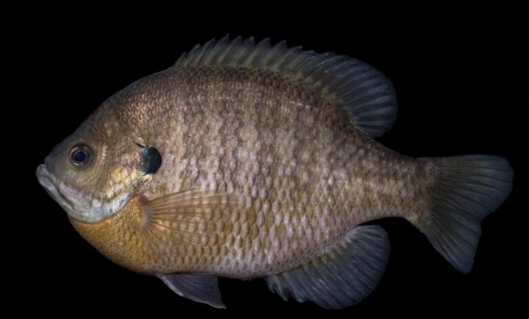
Photo: USFWS Mountain-Prairie, Public domain
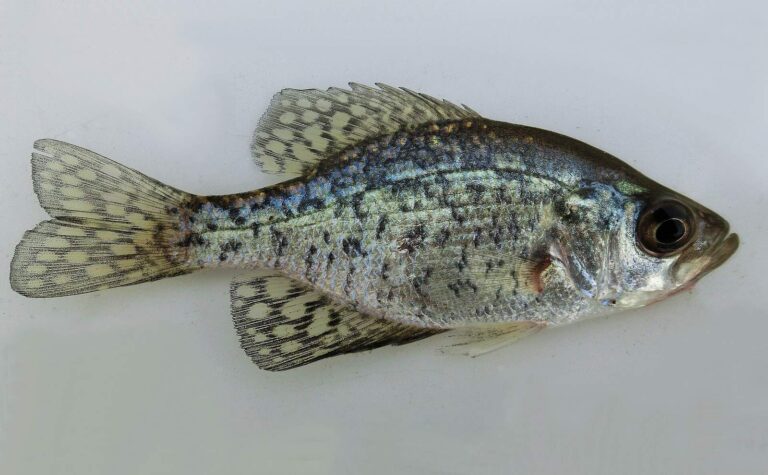
Photo: WBeckon, CC BY-SA 3.0


Photo: (c) Curtis Meyers, some rights reserved (CC BY-SA), CC BY-SA 4.0


Photo: USFWS Mountain-Prairie, Public domain
Questions folks bring up about Chesterfield County
How many public landings does SCDNR map in Chesterfield County?
6 landings and launches, named in the access list above.
Which reservoir or pond in Chesterfield County is the biggest South Carolina water?
It is Lake Juniper, size not printed.
Which fish lead SCDNR lists close to Chesterfield County?
SCDNR access lists name Bluegill on the most lake pages within 50 miles, then Largemouth Bass, Redear Sunfish and Black Crappie.
Where do Chesterfield County anglers stock up on shrimp and minnows?
There are 2; C & H Bait & Tackle is one.
In what town does Chesterfield County keep its courthouse?
It is Chesterfield.
What will a year of fishing Chesterfield County cost?
Plan on $10 (in-state) or $35 (out-of-state) for twelve months of freshwater fishing.
Which counties border Chesterfield County?
Darlington County, Marlboro County and Lancaster County lie nearest.
How many crappie may be kept in Chesterfield County?
Statewide: Crappie: 20 daily, size 8 inches min. A guide row naming a lake can change it.
Under which SCDNR region is Chesterfield County listed?
SCDNR Region 2, going by the majority of its SCDNR access records.
Which Chesterfield County waters carry their own guide row?
1 water with a page here have a guide row of their own, beginning with Great Pee Dee River.
Which SCDNR record traces to Chesterfield County water?
Flathead Catfish, 113-7 as listed, from Great Pee Dee River (2026).
Hitch the boat for Chesterfield County
Check a lake's own guide row before keeping fish.