Fishing in Beaufort County, South Carolina
County seat: Beaufort. Population 187,117 (2020). SCDNR Region 4.
- 7bank and pier sites
- 29landings
- 23river pages
 Pick for bluegillPiscifun Carbon X ultralight spinning reel28% OFFSale $57.99
Photo of Port Royal Sound: sailn1, CC BY 2.0
The fishing makeup of Beaufort County
Beaufort is where Beaufort County keeps its seat, in a county of 187,117 at the last census. By SCDNR access records, the county falls mostly in SCDNR Region 4.
Within the county line SCDNR places 29 landings and paddle launches and 7 piers and bank sites. Paddle or wade Broad River, Combahee River and May River, each with a page. The county's coast brings 2 coastal water pages, 12 artificial reef areas and 7 saltwater piers.
U.S. Census Bureau, 2020 Census counts (TIGERweb) and the 2023 Gazetteer, read November 9, 2026. SCDNR South Carolina Public Water Access layer (ArcGIS service, the data behind the SCDNR fishing access map), read November 9, 2026.
SCDNR access pins scattered over Beaufort County
SCDNR Public Water Access layer and lake points, checked November 9, 2026.
Which Beaufort County lakes have full write-ups
From Beaufort, these lakes beyond the Beaufort County boundary are the nearest with pages.
| Lake | From Beaufort | Size | Landings | Kind | SCDNR species list |
|---|---|---|---|---|---|
| Webb Center Lakes | 36 miles west | 10 acres | 0 | mapped lake | none on SCDNR lists |
| Lake George Warren | 37 miles northwest | 400 acres | 2 | SCDNR state lake | Largemouth Bass, Bluegill, Redear Sunfish |
Surface acres and depth as SCDNR prints them on its page for this lake, read November 9, 2026. Sizes SCDNR does not print show as mapped outline area. Species as SCDNR lists them at its access points.
 For the bluegill herePiscifun Carbon XT ultralight spinning reel25% OFFSale $59.99
Counting SCDNR species entries around Beaufort County
Bars show how many lakes within 100 miles of Beaufort list each fish; Black Crappie tops the count.
SCDNR Public Water Access species lists, counted per lake page within 100 miles; an occurrence list, not a catch survey.
River and creek guides for Beaufort County
- Broad Rivertidal, 31 SCDNR accesses, 8 USGS gauges
- Combahee Rivertidal, 6 SCDNR accesses, 2 USGS gauges
- May Rivertidal, 4 SCDNR accesses
- New Rivertidal, 4 SCDNR accesses, 1 USGS gauge
- Beaufort Rivertidal, 3 SCDNR accesses, 1 USGS gauge
- Mackay Creektidal, 3 SCDNR accesses
- Whale Branchtidal, 3 SCDNR accesses
- North Winbee Creektidal, 2 SCDNR accesses
- Battery Creektidal, 1 SCDNR access
- Brickyard Creektidal, 1 SCDNR access
- Broad Creektidal, 1 SCDNR access
- Capers Creektidal, 1 SCDNR access
- Chechessee Rivertidal, 1 SCDNR access
- Colleton Rivertidal, 1 SCDNR access
- Cowen Creektidal, 1 SCDNR access
- Factory Creektidal, 1 SCDNR access
- Haigh Creektidal, 1 SCDNR access
- Huspah Creektidal, 1 SCDNR access
- Jenkins Creektidal, 1 SCDNR access
- Lucy Point Creektidal, 1 SCDNR access
- Old House Creektidal, 1 SCDNR access
- Station Creektidal, 1 SCDNR access
- Wards Creektidal, 1 SCDNR access
USGS gauges reporting from Beaufort County
| USGS gauge | Latest reading | Time (ET) |
|---|---|---|
| Broad River Near Beaufort, Sc | 0.12 ft gage height | Nov 12 7:45 pm |
| Skull Creek Near Hilton Head, Sc | 1.19 ft gage height | Nov 12 8:15 pm |
| Beaufort River At Beaufort, Sc | 0.05 ft gage height | Nov 12 7:45 pm |
| Mackay Crk At Cc Haigh Landing Nr Hilton Head, Sc | 0.22 ft gage height | Nov 12 7:30 pm |
| New River At Sc 46, Near Hardeeville, Sc | 12.70 ft gage height | Nov 12 8:00 pm |
US Geological Survey provisional data, retrieved Nov 12, 2026 8:32 pm ET. Provisional readings can be revised.
SCDNR South Carolina Public Water Access layer (ArcGIS service, the data behind the SCDNR fishing access map), read November 9, 2026. USGS Water Data for the Nation, live through the site, retrieved on page view.
Coastal fishing water of Beaufort County
Coastal pages for Beaufort County
- Port Royal Soundsound
- Trenchards Inletinlet
Reef sites tied to Beaufort County
- CCA-Edisto 40' ReefPA-31
- Fripp Island ReefPA-38
- PA-39
- Hunting Island Reef (6HI)PA-40
- General Gordon ReefPA-41
- Beaufort 45' ReefPA-42
- Parris Island ReefPA-43
- Betsy Ross ReefPA-44
- Fish America ReefPA-45
- White Water ReefPA-47
- Eagle's Nest ReefPA-48
- Hilton Head ReefPA-49
Saltwater piers in Beaufort County
- Broad River PierBroad River
- Charles C. Haigh, Jr. Pier on Mackay CreekMackay Creek
- Daufuskie Island Dock and Float Pier on New RiverNew River
- Henry C. Chambers Waterfront Park Pier on Beaufort RiverBeaufort River
- Lobeco Pier on Whale BranchWhale Branch
- Old House Creek PierOld House Creek
- Wimbee Pier on North Winbee CreekNorth Winbee Creek
Plan on $10 (in-state) or $35 (out-of-state) for twelve months of freshwater fishing. Fishing the tide adds the saltwater license at $15 for residents.
Saltwater limits South Carolina piers
USGS Geographic Names Information System point for this water, read November 9, 2026. SCDNR Marine Artificial Reef map layers and the SCDNR reef sheet for each permit area (SCDNR reef program), read November 9, 2026. SCDNR South Carolina Public Water Access layer (ArcGIS service, the data behind the SCDNR fishing access map), read November 9, 2026. License prices as printed on the SCDNR license pricing pages (dnr.sc.gov), read November 9, 2026.
Where Beaufort County boats go in
- Alljoy Boat Ramp on May RiverMay River, boat ramp, 2 lanes, concrete or paved, courtesy dock
- Brickyard Creek Boat RampBrickyard Creek, boat ramp, 1 lane, concrete or paved
- Broad Creek Boat RampBroad Creek, boat ramp, 1 lane, concrete or paved
- Broad River Boat RampBroad River, boat ramp, 2 lanes, concrete or paved, courtesy dock, fishing pier
- Buckingham Boat Ramp on Mackay CreekMackay Creek, boat ramp, 1 lane, concrete or paved
- Butchs Island Boat Ramp on Wards CreekWards Creek, boat ramp, 1 lane, concrete or paved
- CC Haigh Jr Boat Ramp on Mackay CreekMackay Creek, boat ramp, 2 lanes, concrete or paved, courtesy dock
- Capers Boat RampCapers Creek, boat ramp, 1 lane, gravel
- Eddings Boat Ramp on Jenkins CreekJenkins Creek, boat ramp, 2 lanes, concrete or paved, courtesy dock
- Edgar Glenn Boat Ramp on Chechessee RiverChechessee River, boat ramp, 2 lanes, concrete or paved, courtesy dock
- Freedom Mall Boat Ramp on Beaufort RiverBeaufort River, boat ramp, 1 lane, concrete or paved, courtesy dock
- Grays Hill Boat Ramp on Whale BranchWhale Branch, boat ramp, 2 lanes, concrete or paved, courtesy dock
- HE Trask Sr Boat Ramp on Colleton RiverColleton River, boat ramp, 2 lanes, concrete or paved, courtesy dock
- Paige Point Boat Ramp on Huspah CreekHuspah Creek, boat ramp, 2 lanes, concrete or paved, courtesy dock
- Parris Island Boat Ramp on Battery CreekBattery Creek, boat ramp, 2 lanes, concrete or paved, courtesy dock
- Pigeon Point Boat Ramp on Beaufort RiverBeaufort River, boat ramp, 1 lane, concrete or paved, courtesy dock
- Port Royal Boat Ramp on Port Royal SoundPort Royal Sound, boat ramp, 3 lanes, concrete or paved, courtesy dock
- Sams Point Boat Ramp on Lucy Point CreekLucy Point Creek, boat ramp, 2 lanes, concrete or paved, courtesy dock
- Station Creek Boat RampStation Creek, boat ramp, 3 lanes, concrete or paved, courtesy dock
- Steel Bridge Boat Ramp on Combahee RiverCombahee River, boat ramp, 2 lanes, concrete or paved, courtesy dock
- Sugar Hill Boat Ramp on Combahee RiverCombahee River, boat ramp, 1 lane, dirt
- Wallace Boat Ramp on Haigh CreekHaigh Creek, boat ramp, 1 lane, concrete or paved, courtesy dock
- Warf Street Boat Ramp on May RiverMay River, boat ramp, 1 lane, concrete or paved, courtesy dock
- White Hall Boat Ramp on Factory CreekFactory Creek, boat ramp, 4 lanes, concrete or paved, courtesy dock
- Winbee Creek Boat Ramp on North Winbee CreekNorth Winbee Creek, boat ramp, 1 lane, concrete or paved, courtesy dock, fishing pier
- Penn Center Dock on Cowen CreekCowen Creek, paddle launch
- Public Boat Dock Facility on May RiverMay River, boat ramp, other (see comments), courtesy dock
- Public Boat Dock Facility on May RiverMay River, paddle launch
- Seabrook Paddle Launch on Whale BranchWhale Branch, paddle launch
Shore and pier access around Beaufort County
- Broad River PierBroad River, pier
- Charles C. Haigh, Jr. Pier on Mackay CreekMackay Creek, pier
- Daufuskie Island Dock and Float Pier on New RiverNew River, pier
- Henry C. Chambers Waterfront Park Pier on Beaufort RiverBeaufort River, pier
- Lobeco Pier on Whale BranchWhale Branch, pier
- Old House Creek PierOld House Creek, pier
- Wimbee Pier on North Winbee CreekNorth Winbee Creek, pier
SCDNR South Carolina Public Water Access layer (ArcGIS service, the data behind the SCDNR fishing access map), read November 9, 2026. The SCDNR layer carries no fee or hours field.
The state guide limits that reach Beaufort County
These statewide freshwater limits cover Beaufort County unless the guide prints a rule for the lake or river. A total of 40 game fish may be kept in any one day (freshwater), not exceeding the species limits (guide p. 28). Plan on $10 (in-state) or $35 (out-of-state) for twelve months of freshwater fishing.
| Species | Size limit | Daily limit |
|---|---|---|
| American Eel | 9 inches min | 25 |
| Blue Catfish | See limits in Freshwater Nongame Fishing Regulations section. | See limits in Freshwater Nongame Fishing Regulations section. |
| Bream | Any length | 30 |
| Redbreast Sunfish | Any length | 15 |
| Crappie | 8 inches min | 20 |
| Walleye & Sauger | Any length | No more than 8 combined total of walleye or sauger |
| Chain Pickerel | Any length | 30 |
| Redfin Pickerel | Any length | 30 |
| Yellow Perch | Any length | 30 |
| Smallmouth Bass | 12 inches min | No more than 5 combined total of smallmouth, largemouth, redeye bass or their hybrids |
| Redeye (Bartrams) Bass | Any length | No more than 5 combined total of smallmouth, largemouth, redeye bass or their hybrids |
| Largemouth Bass | Any length | No more than 5 combined total of smallmouth, largemouth, redeye bass or their hybrids |
| Spotted Bass | Any length | 15 |
| White Bass | Any length | 10 |
| Striped or Hybrid Bass or a combination | Any length | 10 |
Water-specific limits across Beaufort County
- Combahee RiverStriped or Hybrid Bass or a combination: Oct. 1 – June 15: 26 inches min, 3
2026-2027 South Carolina Hunting & Fishing Guide, valid August 14, 2026 to August 14, 2027 (online guide), read November 9, 2026. License prices as printed on the SCDNR license pricing pages (dnr.sc.gov), read November 9, 2026.
SCDNR record entries close to Beaufort County
| Species | Weight as listed | List | Water | Year |
|---|---|---|---|---|
| Muskellunge | 22-8, 42 1/4in | freshwater | Broad River | 2004 |
| Bullhead | 6-6.3 | freshwater | Broad River | 2009 |
| Striped Bass | 46-13 | saltwater | Combahee River | 1993 |
South Carolina state record fish as listed by SCDNR (record list), read November 9, 2026.
Supplies and guides listed for Beaufort County
Stores with fishing gear in Beaufort County
- Academy Sports + Outdoors, 320 Robert Smalls Pkwybait and tackle shop, Beaufort
- Blue Water Bait & Tacklebait and tackle shop, Hilton Head Island
- Bluffton Marine Sports & Supplybait and tackle shop, Bluffton
- Dick's Sporting Goods, 1050 Fording Island Rdbait and tackle shop, Bluffton
- Driftwood Bait Shopbait and tackle shop, Seabrook
- Last Chance Bait & Tacklebait and tackle shop, Port Royal
- Mainline Country Storebait and tackle shop, St Helena Is
- Shelter Cove Harbourbait and tackle shop, Hilton Head Island
- Ship's Store, 1 Shelter Cove Lnbait and tackle shop, Hilton Head Island
- Ship's Store, 13 Shelter Cove Lnbait and tackle shop, Hilton Head Island
- Skull Creek Boathousebait and tackle shop, Hilton Head Island
- South Beach Sport Fishingbait and tackle shop, Hilton Head Island
- Southern Drawl Outfittersbait and tackle shop, Hilton Head Island
- Broad Creek Marinamarina, Hilton Head Island
- Dataw Island Marinamarina, Saint Helena Island
- Freeport Marinamarina, Daufuskie Island
- Fripp Island Excursionsmarina, Saint Helena Island
- Harbour Town Yacht Basinmarina, Hilton Head Island
- Lady's Island Marina Incmarina, Beaufort
- Port Royal Dry Stack Marinamarina, Port Royal
- Port Royal Landing Marina Incmarina, Port Royal
- Safe Harbor Beaufortmarina, Beaufort
- Safe Harbor Port Royalmarina, Port Royal
- Safe Harbor Port Royal Landingmarina, Port Royal
- Safe Harbor Skull Creekmarina, Hilton Head Island
- Shelter Cove Harbour & Marinamarina, Hilton Head Island
- Windmill Harbour Marinamarina, Hilton Head Island
Hired captains around Beaufort County
- A Lure Charterscharter, Beaufort, (843) 644-5873
- All Aboard Charterscharter, Bluffton, (843) 505-0131
- Bayrunner Fishing Charterscharter, Hilton Head Island, (843) 290-6955
- Beaufort Fishing Charters | Beaufort Coastal Adventurescharter, Beaufort, (843) 812-1426
- Bonnie Rae Charterscharter, Hilton Head Island, (843) 683-6060
- Bulldog Fishing Charterscharter, Hilton Head Island, (843) 422-0887
- Captain Eddie's Fishing CHRTRScharter, Saint Helena Island, (843) 838-3782
- Captain Georges Fishing Charterscharter, Fripp Island, (843) 575-8169
- Catmandoo Fishing Charterscharter, Hilton Head Island, (843) 683-4768
- Due South Fishing Expeditionscharter, Beaufort, (843) 941-3416
- EZ – Cat Fishing Charterscharter, Hilton Head Island, (843) 816-0215
- Fishin Coach Charters Inccharter, Bluffton, (843) 368-2126
- Fishin' Tale Charterscharter, Beaufort, (843) 694-3770
- Fishing Charters of Beaufortcharter, Beaufort, (843) 522-2122
- Green Heron Adventurescharter, Beaufort, (843) 263-0166
- Hilton Head Fishing Adventurescharter, Hilton Head Island, (843) 592-0897
- Hilton Head Outfitters & Bike Rentalscharter, Hilton Head Island, (866) 380-1783
- Hilton head by boatcharter, Hilton Head Island, (843) 304-3847
- Hocus Pocus IIcharter, Bluffton, (843) 683-1547
- Just-In Time Charterscharter, Hilton Head Island, (843) 384-7337
Yellow Pages listings (city of business), read November 9, 2026.
Other places to try past Beaufort County
Census places of Beaufort County on this site
- Hilton Head Islandpop. 37,661
- Blufftonpop. 27,716
- Port Royalpop. 14,220
- Beaufortpop. 13,607
- Burtonpop. 6,777
- Laurel Baypop. 5,082
- Yemasseepop. 1,080
County lines around Beaufort County
- Jasper County20 miles west
- Colleton County34 miles north
- Hampton County39 miles northwest
- Dorchester County53 miles north
Piscifun picks that fit a day around Beaufort County


Piscifun and Amazon links are affiliate links; the site earns a commission on qualifying purchases.
Palmetto State fish to know on sight at Beaufort County
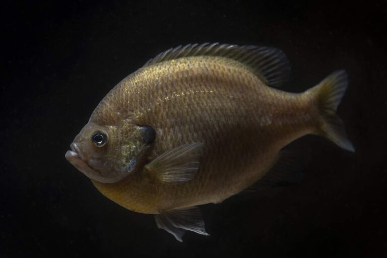
Photo: USFWS Mountain-Prairie, Public domain
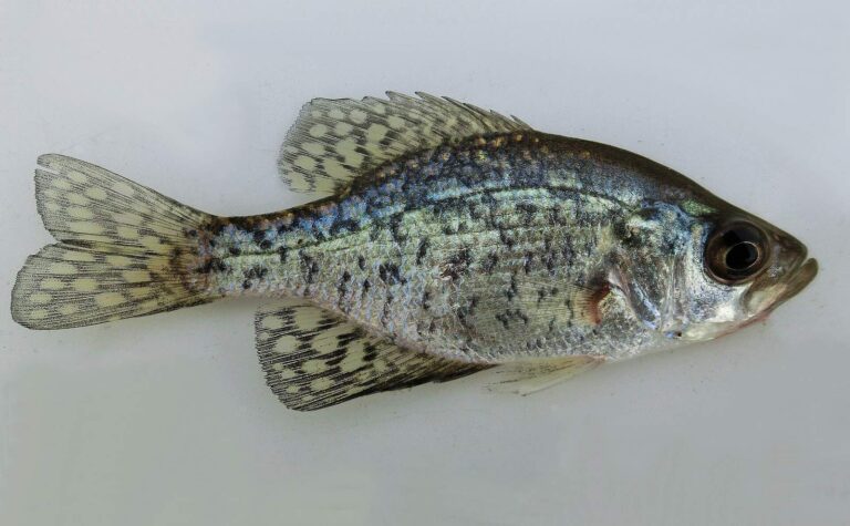
Photo: WBeckon, CC BY-SA 3.0


Photo: USFWS Mountain-Prairie, Public domain

Photo: USFWS Mountain-Prairie, Public domain
Questions folks bring up about Beaufort County
How many public landings does SCDNR map in Beaufort County?
29 landings and launches, named in the access list above.
Which reservoir or pond in Beaufort County is the biggest South Carolina water?
No lake page lies inside the county; Webb Center Lakes, 36 miles from Beaufort, is the nearest.
Which fish lead SCDNR lists close to Beaufort County?
SCDNR access lists name Black Crappie on the most lake pages within 100 miles, then Channel Catfish, Largemouth Bass and Redear Sunfish.
Where do Beaufort County anglers stock up on shrimp and minnows?
There are 27; Academy Sports + Outdoors, 320 Robert Smalls Pkwy is one.
In what town does Beaufort County keep its courthouse?
It is Beaufort.
What will a year of fishing Beaufort County cost?
Plan on $10 (in-state) or $35 (out-of-state) for twelve months of freshwater fishing. Fishing the tide adds the saltwater license at $15 for residents.
Which counties border Beaufort County?
Jasper County, Colleton County and Hampton County lie nearest.
How many crappie may be kept in Beaufort County?
Statewide: Crappie: 20 daily, size 8 inches min. A guide row naming a lake can change it.
Under which SCDNR region is Beaufort County listed?
SCDNR Region 4, going by the majority of its SCDNR access records.
Which Beaufort County waters carry their own guide row?
1 water with a page here have a guide row of their own, beginning with Combahee River.
Which SCDNR record traces to Beaufort County water?
Muskellunge, 22-8, 42 1/4in as listed, from Broad River (2004).
Does Beaufort County reach South Carolina salt water?
Yes: 2 coastal water pages, 12 artificial reef areas and 7 saltwater piers.
Hitch the boat for Beaufort County
Check a lake's own guide row before keeping fish.