Arkansas River Fishing
An Oklahoma river through Wagoner County and 3 other counties.
 Pick for striped bassPiscifun Viper X spinning reel50% OFFSale $39.99
Photo: Michael Karl Witzel, CC BY-SA 2.0
The Arkansas River counted up
The Arkansas River is an Oklahoma river running through Wagoner County and 3 other counties. ODWC treats it as a border water. Count 2 miles as the crow flies to Haskell.
Its flow is logged by 6 USGS gauges. It sits in the ODWC Northeast Region.
We measure from a gauge on the Arkansas River; no river point is published.
USGS GNIS domestic names, Oklahoma stream points, read November 3, 2026; ODWC Where To Fish page, wildlifedepartment.com, read November 3, 2026. Census 2023 places.
What ODWC says about the Arkansas River
- Campgrounds ODWC listsKeystone USACE, Keystone State Park, Skiatook USACE, Birch Lake USACE
ODWC Where To Fish page, wildlifedepartment.com, read November 3, 2026.
Species on the Arkansas River
These fish carry an ODWC source for the Arkansas River.
ODWC Where To Fish pages, stocking reports and the ODWC record table; read November 3, 2026.
 For the striped bass herePiscifun AlumiX spinning reel46% OFFSale $64.99
Gauge numbers from the Arkansas River
| USGS gauge | Latest reading | Time (ET) |
|---|---|---|
| Arkansas River At Ralston, Ok | 530 cfs, 3.58 ft gage height | Nov 5 10:00 pm |
| Arkansas River At Sh 344 Nr Tulsa, Ok | 4,730 cfs, 10.01 ft gage height | Nov 5 9:45 pm |
| Arkansas River At Tulsa, Ok | 10,200 cfs, 4.60 ft gage height | Aug 21 4:30 am Not updated since Aug 21, 2026. |
| Arkansas River Near Haskell, Ok | 2,730 cfs, 4.24 ft gage height | Nov 5 10:00 pm |
US Geological Survey provisional data, retrieved Nov 5, 2026 10:34 pm ET. Provisional readings can be revised.
Cubic feet per second and stage here come from Arkansas River at Ralston, OK, Arkansas River at SH 344 nr Tulsa, OK, Arkansas River at Tulsa, OK and Arkansas River near Haskell, OK.
USGS instantaneous values, provisional; site list read November 3, 2026.
Reaching the Arkansas River
The closest mapped ramps to the Arkansas River appear below; none is on it.
Stay on public ground along the Arkansas River unless an owner agrees.
USACE Tulsa District recreation features (boat ramp layer, inventory year 2021), read November 3, 2026; USGS gauges.
Stringer rules on the Arkansas River
| Species | Daily limit | Size limit |
|---|---|---|
| Largemouth and/or Smallmouth Bass | 6 (combined) | 1 (one) over 16 inches |
| Spotted Bass | no daily limit | no size limit |
| Channel and/or Blue Catfish | 15 (combined) | Only 1 Blue Catfish over 30 inches |
| Flathead Catfish | 5 | no size limit |
| White and/or Black Crappie | 37 (combined) | no size limit |
| Striped Bass | 5 (except Lake Texoma) | no size limit |
| Striped Bass Hybrids | 20 | Only 5 fish over 20 inches |
| White Bass | no daily limit | no size limit |
| Trout | See trout regulations | no size limit |
| Walleye, Sauger and/or Saugeye | 6 (combined) | 14 inch minimum |
| Paddlefish | See paddlefish regulation | no size limit |
| Alligator Gar | 1 | no size limit |
For black bass in moving water ODWC prints: In rivers and streams: black bass (largemouth, smallmouth, and spotted): six combined per day, only one of which may be a smallmouth bass. Largemouth and smallmouth bass must be 14 inches or longer. No size limit on spotted bass.
The Arkansas River follows the statewide table plus any area rule.
Area rules covering the Arkansas River
- Daily/size LimitsWalleye, sauger and saugeye: six combined per day/16-inch minimum, including all reservoirs and unimpounded tributaries from Keystone Dam downstream to the Oklahoma state line.
- MethodsProhibited.
- Methodssnagging between April 15-May 15 in the Arkansas River from Zink Dam for 800 feet downstream. In the tailwaters area immediately below Webbers Falls Lock and Dam; bowfishing, gigs, spears, spearguns and snagging is prohibited in the first 1,000 feet. Trotlines, throwlines, limblines, juglines and yo-yos are prohibited below Webbers Falls Lock and Dam for a distance of one mile.
Area Specific Fishing Regulations on the ODWC page, as printed, wildlifedepartment.com, read November 3, 2026.
The Arkansas River and the state line
Walleye, sauger and saugeye: six combined per day/16-inch minimum, including all reservoirs and unimpounded tributaries from Keystone Dam downstream to the Oklahoma state line.
Anglers 18 and older carry an Oklahoma fishing license ($31 annual for residents, $81 for nonresidents in 2026).
Limits as printed on the ODWC statewide daily and size limits page (2026-2027 Oklahoma Fishing and Hunting Regulations (ODWC); PDF), read November 3, 2026.
Record catches pulled off the Arkansas River
| Species | Weight | Division | Angler | Date |
|---|---|---|---|---|
| Sturgeon, Shovelnose | 2 lbs 15.50 ozs | unrestricted | Paul R. Foreman | October 12, 1997 |
| Goldeye | 2 lbs 8.00 ozs | rod and reel | James R. Smith | April 27, 1996 |
| Sturgeon, Shovelnose | 1 lbs 10.00 ozs | rod and reel | Tommy Jenkins | May 7, 1996 |
ODWC state record fish list (keeper: Oklahoma Department of Wildlife Conservation), read November 3, 2026.
Contests launched on the Arkansas River
Schedules and printed results for the Arkansas River share one page.
How the Arkansas River stacks against close streams
The closest river page to the Arkansas River is Verdigris River, about 19 miles away.
| River | Distance | USGS gauges | Corps ramps | ODWC species |
|---|---|---|---|---|
| Arkansas River | 6 | 0 | 5 | |
| Verdigris River | 19 miles east | 4 | 0 | 0 |
| Neosho River | 19 miles east | 5 | 0 | 0 |
| North Canadian River | 31 miles south | 13 | 0 | 0 |
| Deep Fork River | 32 miles south | 2 | 0 | 0 |
| Caney River | 36 miles north | 3 | 0 | 0 |
USGS gauges, USACE ramp layer, ODWC species lines; read November 3, 2026.
Short haul from the Arkansas River
Impounded water a county or two from the Arkansas River
- Taft Lake8 miles
- Bixhoma Lake10 miles
- Lock and Dam 1818 miles
- Veterans Park Pond (Jenks)23 miles
ODWC bait stops for the Arkansas River
- Woody's Bait & Tackle20913 W 8th St, Sand Springs, OK 74063, (918) 245-8491
- Walmart Supercenter (Sand Springs)220 OK-97, Sand Springs, OK 74063, (918) 245-0213
- Keystone Lake Bait & Store998 W Oak Grove Rd, Cleveland, OK 74020, (918) 899-2649
- Bait ShopMannford, OK 74044, (918) 865-3335
- North Harvard Bait3326 N Harvard Ave, Tulsa, OK 74115, (918) 313-3788
- Mister Bass Inc4000 W Rogers Blvd, Skiatook, OK 74070, (918) 396-3848
- Walmart Supercenter (Skiatook)700 W Rogers Blvd, Skiatook, OK 74070, (918) 396-1244
- Walmart Supercenter (Owasso)12101 E 96th St N, Owasso, OK 74055, (918) 272-6609
Grab a dozen shiners before the Arkansas River
- Academy Sports + Outdoors Muskogeesporting goods store, Muskogee, 15 miles
- Jordan's Bait & Tacklebait and tackle shop, Muskogee, 16 miles
- Mike's Outdoorssporting goods store, Muskogee, 17 miles
- Jimmy Houston Marinemarina, Broken Arrow, 18 miles
- Dick's Sporting Goods Broken Arrowsporting goods store, Broken Arrow, 19 miles
Licensed guide outfits that run the Arkansas River
- Adrenaline Rush Adventuresfishing guide, (918)623-6946
- Backyard Okie Noodling Llcfishing guide, (918)955-3093
- Captain Kinsey Guide Servicefishing guide, (405)314-1882
- Experience Fishing . Comfishing guide, (405)620-1022
- Hayes Guide Servicefishing guide, (991)869-8663
- Lucky Catz Fishingfishing guide, (405)679-8646
- Ozark River Guidesfishing guide, (918)645-8050
- Rip’Nlips Guide Servicefishing guide, (479)644-6165
Oklahoma towns close to the Arkansas River
- Haskell2 miles
- Coweta10 miles
- Bixby16 miles
- Muskogee17 miles
Other Oklahoma rivers near the Arkansas River
- Verdigris River19 miles
- Neosho River19 miles
- North Canadian River31 miles
- Deep Fork River32 miles
- Caney River36 miles
the Arkansas River split up by county line
- Wagoner County
- Pawnee County
- Tulsa County
- Muskogee County
Piscifun gear a Sooner State angler might carry to the Arkansas River


Piscifun and Amazon links are affiliate links; the site earns a commission on qualifying purchases.
Sorting out the Arkansas River fish by photo
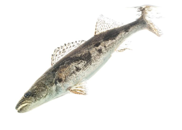
Photo: USFWS Mountain-Prairie, CC BY 2.0

Photo: USFWS Fish and Aquatic Conservation, Public domain

Photo: USFWS Pacific Southwest Region, Public domain
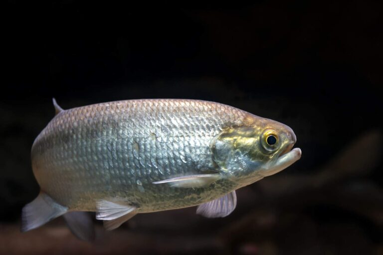
Photo: USFWS Mountain-Prairie, Public domain

Before you drive out to the Arkansas River: common questions
Which Oklahoma counties does the Arkansas River cross?
Check the map around Wagoner, Pawnee, Tulsa and Muskogee counties.
Which USGS station number covers the Arkansas River?
Live readings from Arkansas River at Ralston, OK and Arkansas River at SH 344 nr Tulsa, OK fill the flow band.
How many Corps ramps touch the Arkansas River?
No mapped ramp is on it; use public parks or crossings with care.
Is there a black bass length limit on the Arkansas River?
In rivers and streams: black bass (largemouth, smallmouth, and spotted): six combined per day, only one of which may be a smallmouth bass. Largemouth and smallmouth bass must be 14 inches or longer. No size limit on spotted bass. Extra rules apply, listed above.
May a visitor from out of state work the Arkansas River?
Anglers 18 and older carry an Oklahoma fishing license ($31 annual for residents, $81 for nonresidents in 2026). Walleye, sauger and saugeye: six combined per day/16-inch minimum, including all reservoirs and unimpounded tributaries from Keystone Dam downstream to the Oklahoma state line.
Which species does ODWC list for the Arkansas River?
Named fish include sauger, paddlefish, striped bass, goldeye and shovelnose sturgeon.
Where are shiners and worms sold close to the Arkansas River?
Try Woody's Bait & Tackle, 20913 W 8th St, Sand Springs, OK 74063, from the ODWC list.
Which banks of the Arkansas River are open to the public?
Fish from public sites or with permission; private land lines most banks.
Which ODWC record fish was landed on the Arkansas River?
Sturgeon, Shovelnose, 2 lbs 15.50 ozs in the unrestricted division, landed by Paul R. Foreman on October 12, 1997.
Load the canoe for the Arkansas River
Check the gauge, then pick your put-in.