Fishing in Dent County, Missouri
Courthouse in Salem. MDC manages its fish from the MDC Ozark Region.
- 3lake pages
- 3ramps
- 6river pages
 Pick for troutPiscifun Carbon X ultralight spinning reel28% OFFSale $57.99
Photo of Meramec River: Kbh3rd, CC BY-SA 3.0
Dent County through an angler's eyes
The courthouse town for Dent County is Salem, and the county counted 14,421 people in 2020. Water covers 1.7 square miles here, next to 753 square miles of land. MDC places it within the MDC Ozark Region.
Lake pages count 3 waters and 68 acres; Macs Lake is the biggest of them. Boaters have 3 public ramps on the MDC and Corps maps, 0 flagged as accessible. Bank fishing gets help from 2 fishing docks, 5 jetties and 1 cleaning station that MDC mapped. For trout, look to Montauk State Park and Current River.
Census 2020 population and 2023 Gazetteer areas; MDC Managed Public Waterbody outlines, boat ramp/access, dock, jetty and fish attractor layers; USACE ramp layers; retrieved October 2026.
 For the trout herePiscifun Carbon XT ultralight spinning reel25% OFFSale $59.99
Pinning the fishing water of Dent County
MDC boat ramp/access and dock layers, USACE ramps, MDC lake label points and MDC stream access areas. Checked October 2026.
Dent County still water ranked by size
| Lake | Acres | Ramps | Motor note | Fish MDC names |
|---|---|---|---|---|
| Macs Lake | 26 | 1 | ||
| Blackwell Lake | 26 | 1 | ||
| Shawnee Lake | 16 | 1 |
From Salem, the next lake pages sit outside Dent County, listed by distance.
| Lake | From Salem | Acres | Ramps | Motor note | Fish MDC names |
|---|---|---|---|---|---|
| Scioto Lake | 25 miles north | 5 | 0 | ||
| Schuman Park Lake | 25 miles northwest | 5 | 0 | ||
| Towell Lake | 26 miles north | 97 | 1 | largemouth bass, crappie, redear sunfish | |
| Rinquelin Trail Lake | 46 miles northwest | 26 | 1 | ||
| Sims Valley Community Lake | 47 miles south | 42 | 1 | largemouth bass, bluegill, redear sunfish | |
| Austin Community Lake | 49 miles southwest | 22 | 1 |
MDC Managed Public Waterbody outlines (GIS acres), MDC 2026 Fishing Prospects species and boating notes; retrieved October 2026.
What biologists report in lakes by Dent County
Counted across lake pages within 50 miles of Salem, channel catfish is the fish MDC names most often.
Species named in MDC 2026 Fishing Prospects text, the MDC state record list and MDC trout program waters, counted per lake page within 50 miles; not a full survey.
More MDC-managed ponds across Dent County
6 additional MDC-managed waters of Dent County are listed with acreage.
| Water | Acres | Attractors | Nearest place |
|---|---|---|---|
| Howes Mill Pond | 6 | 0 | Viburnum |
| Demo Pond 2 | 4 | 0 | Salem |
| Howes Mill Lake | 3 | 0 | Viburnum |
| Montauk State Park | 2 | 0 | Licking |
| Demo Pond 1 | 1 | 0 | Salem |
| 3 Acre Lake | 1 | 0 | Edgar Springs |
MDC Managed Public Waterbody outlines and fish attractor layer, retrieved October 2026.
River pages that cross Dent County
- Meramec RiverRed Ribbon trout area, smallmouth and goggle-eye management water, 13 MDC ramps, 12 access areas, 229 mi in Missouri
- Current RiverBlue Ribbon and White Ribbon trout area, 4 MDC ramps, 3 access areas, 141 mi in Missouri
- Pigeon Creektrout park water, Trout Park trout area, 1 MDC ramp, 21 mi in Missouri
- Little Piney CreekBlue Ribbon and White Ribbon trout area, 1 access area, 44 mi in Missouri
- Barren ForkBlue Ribbon trout area, 19 mi in Missouri
- Huzzah Creekgoggle-eye management water, 1 MDC ramp, 1 access area, 36 mi in Missouri
River readings across Dent County today
| USGS gauge | Latest reading | Time (ET) |
|---|---|---|
| Current River At Montauk State Park, Mo | 62 cfs, 1.48 ft gage height | Nov 11 6:15 pm |
US Geological Survey provisional data, retrieved Nov 11, 2026 6:33 pm ET. Provisional readings can be revised.
MDC stream access areas and boat ramps, MDC trout and smallmouth management layers, USGS NHD lengths and USGS gauges; retrieved October 2026.
MDC trout water in Dent County
Trout park fishing at Montauk State Park needs a daily trout tag during the main season. Keeping trout takes a Missouri trout permit on top of the fishing permit: $12 for residents and $24 for nonresidents 16 and older.
Dent County trout segments by ribbon
| Area | Water and segment | Length | Daily | Lures |
|---|---|---|---|---|
| Blue Ribbon | Current River: River and its tributaries from lower boundary of Montauk State Park to the river crossing on Dent County Road 6510/Shannon County Big Creek | At least 18" | 1 | Artificial lures and flies |
| White Ribbon | Current River: Downstream from the river crossing on Dent County Road 6510/Shannon County Big Creek Road at Cedargrove — 7.7 miles | Rainbows: none; Browns: at least 15" | 4 | All |
| Trout park | Daily tag | Catch and keep | Winter catch and release |
|---|---|---|---|
| Montauk State Park | $5 age 16 and up, $3 age 15 and under | March 1–Oct. 31, 2026 | Nov. 13, 2026–Feb. 8, 2027 (flies only; trout permit required) |
- Montauk State ParkRainbow Trout and Brown Trout, Open and stocked daily from March 1 through Oct. 31 (booklet p.24). 2026: about 20,000 trout stocked among the four parks for opening day; more than 600,000 trout annually at the four trout parks and
- Montauk State ParkRainbow Trout, 7,500 rainbow trout, Stocked "in the days leading up to Sunday, March 1" 2026; 2,256 anglers bought tags for opening day.
- Current River (River and its tributaries from lower boundary of Montauk State Park to the river crossing on Dent County Road 6510/Shannon County Big Creek Road at Cedargrove — 9 miles)Brown Trout, These areas on the Current River and North Fork of the White River are stocked with brown trout, and the Eleven Point River is stocked with rainbows. (Blue Ribbon Trout Area)
- Current River (Downstream from the river crossing on Dent County Road 6510/Shannon County Big Creek Road at Cedargrove — 7.7 miles)Rainbow Trout (periodic; some also receive brown trout), All receive periodic stockings of rainbow trout, and some also receive brown trout. (White Ribbon Trout Area)
MDC trout program statements (2026 regulations booklet, MDC news releases and area pages); MDC publishes no per-water stocking table; trout areas and trout parks as printed in the 2026 regulations booklet pp. 24 to 27.
Putting a boat or a bobber in at Dent County
- Indian Trail Conservation Area on Blackwell LakeBlackwell Lake, boat ramp
- Shawnee Mac Lakes Conservation AreaShawnee Lake, boat ramp, parking, privy nearby
- Shawnee Mac Lakes Conservation Area on Macs LakeMacs Lake, boat ramp, parking, privy nearby
Places to fish from a dock in Dent County (3)
- Fishing dock at Blackwell Lake, Indian Trail Conservation Area1 dock
- Fishing dock at Macs Lake, Shawnee Mac Lakes Conservation Area1 dock
- Fishing jetties at Montauk State Park, Montauk Fish Hatchery5 jetties, 1 cleaning station
MDC boat ramp/access, fishing dock, jetty and cleaning station layers; USACE Little Rock District ramp layers; retrieved October 2026.
Shops serving Dent County from across the line
- Toad's Sportsman Shopbait and tackle shop, Rolla, 23 miles
- White Buffalo Fly Shopfly shop, Rolla, 25 miles
- Academy Sports + Outdoors Rollasporting goods store, Rolla, 26 miles
- The Lakeshore Marinamarina, Cuba, 31 miles
- Vienna Marine LLCbait and tackle shop, Vienna, 44 miles
Yellow Pages and chain store listings; straight-line distances from Salem.
Length and creel limits on Dent County water
The statewide rows apply across Dent County except where MDC prints an exception.
| Species | Limit | Season |
|---|---|---|
| Black bass (largemouth, smallmouth, spotted/Kentucky) | 6 a day | All year |
| Black bass (largemouth, smallmouth, spotted/Kentucky) (Ozark streams) | 6 a day; 12" minimum | May 23, 2026–Feb. 28, 2027 |
| Channel catfish | 10 a day | All year |
| Blue catfish | 5 a day | All year |
| Flathead catfish | 5 a day | All year |
| Crappie (black and white) | 30 a day | All year |
| Goggle-eye (Ozark, rock, and shadow bass) and warmouth | 15 a day; 7" minimum | All year |
| Muskellunge | 1 (daily limit is 1 muskellunge or 1 northern pike); 36" minimum | All year |
| Northern pike | 1 (daily limit is 1 muskellunge or 1 northern pike) | All year |
| Paddlefish (spoonbill) | 2 a day; 32" minimum (eye to fork of tail) | March 15–April 30 |
| Pickerel (chain and grass) | 6 a day | All year |
| Shovelnose sturgeon | 10 a day; 30" maximum (snout to fork of tail) | All year |
| Trout (rainbow and brown) | 4 a day; Rainbow: none; Brown: 15" minimum in streams | All year |
| Walleye and sauger | 4 a day; 15" minimum | All year |
| White, yellow, and striped bass and their hybrids | 15 a day; No more than 4 longer than 18" | All year |
MDC exceptions printed for Dent County (10)
| Water | Where | Rule |
|---|---|---|
| Current River | In Dent, Texas, and Shannon counties | The use of porous-soled waders is prohibited. See Page 24. |
| Current River | From Montauk State Park to the river crossing on Dent County Road 6510/Shannon County Big Creek Road at Cedargrove | ▶ Blue Ribbon Trout Area — See Page 26 for special regulations. |
| Current River | From Montauk State Park to the river crossing on Dent County Road 6510/Shannon County Big Creek Road at Cedargrove | Only flies and artificial lures may be used, and soft plastic baits and natural and scented baits are prohibited when fishing for any species. |
| Current River | From Montauk State Park to the river crossing on Dent County Road 6510/Shannon County Big Creek Road at Cedargrove | Gigging, bowfishing, and using an atlatl are prohibited, and fish taken by these methods may not be possessed on these waters or their banks. |
| Current River | From the river crossing on Dent County Road 6510/ Shannon County Big Creek Road at Cedargrove to the Arkansas line | Nongame fish — The daily limit may include no more than 5 hog suckers. |
| Dry Fork Creek | Mainstem and its tributaries | Black bass — The daily and possession limit is 12 fish and may include no more than 6 largemouth bass and smallmouth bass, combined total of both species. |
| Dry Fork Creek | Mainstem and its tributaries | Spotted bass — No minimum length limit |
| Dry Fork Creek | In Phelps and Dent counties, upstream from the elevated cable crossing | Trout — 15" minimum length limit; daily limit 2 |
| Meramec River | From Highway 19 bridge in Dent County to Pacific Palisades Conservation Area | Goggle-eye and warmouth — 8" minimum length limit |
| Current River | From the river crossing on Dent County Road 6510/Shannon County Big Creek Road at Cedargrove downstream to the Arkansas line | On the Current River from the river crossing on Dent County Road 6510/Shannon County Big Creek Road at Cedargrove downstream to the Arkansas line, only 5 hog suckers may be included in a daily limit. |
Limits and seasons as printed in A Summary of Missouri Fishing Regulations 2026 (MDC, effective March 1, 2026), page 20 (booklet PDF); retrieved October 27, 2026. Rules as printed in A Summary of Missouri Fishing Regulations 2026 (MDC, effective March 1, 2026) (booklet PDF, Special Regulations on Large Lakes and on Rivers and Streams); checked against the current Wildlife Code October 27, 2026.
Record-list catches near Dent County
No Dent County lake holds a listed record, but these nearby waters do.
| Species | Weight | Method | Water | Date | Source |
|---|---|---|---|---|---|
| River Redhorse | 10 lbs. 3 oz. | pole and line | Osage Fork Gasconade River | May 16, 2026 | MDC news release |
MDC State Record Fish list (first page of 135 records readable) and MDC news releases, retrieved October 2026.
Neighbouring Dent County
Towns with fishing pages in Dent County
- Salempop. 4,608
Neighbouring counties of Dent County
- Phelps County25 miles northwest
- Crawford County27 miles north
- Shannon County32 miles south
- Reynolds County33 miles southeast
Reels from Piscifun worth bringing to Dent County


Piscifun and Amazon links are affiliate links; the site earns a commission on qualifying purchases.
Telling the fish of Dent County apart by photo
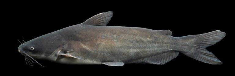
Photo: USFWS Mountain Prairie, Public domain

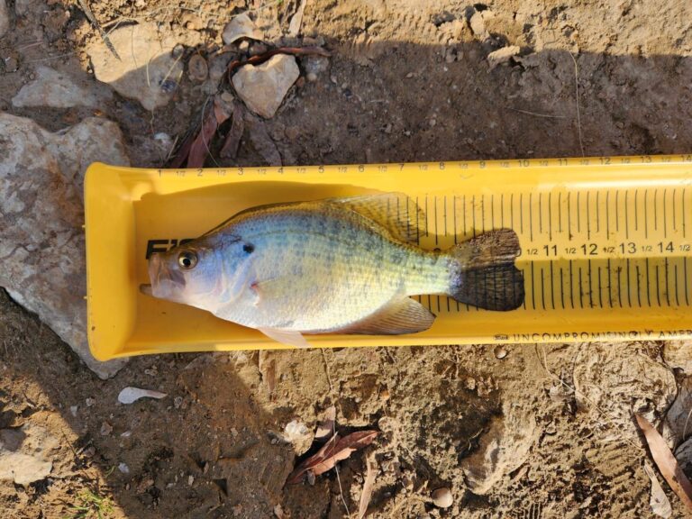
Photo: Dominic, CC BY 4.0


Photo: USFWS Mountain-Prairie, Public domain
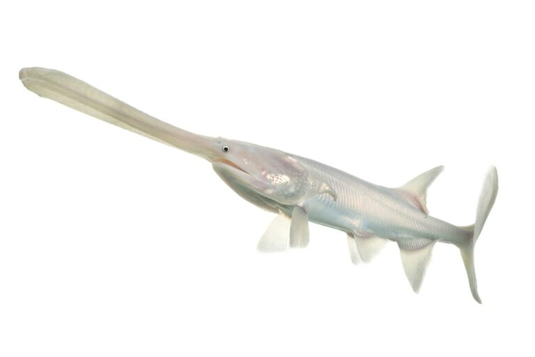
Photo: USFWS Mountain Prairie, Public domain

Hunting in Dent County
Public hunting land, seasons and processors for Dent County are on State Hunting Spots, our sister site.
What Show-Me anglers ask about Dent County
How many MDC and Corps ramps serve Dent County?
3 public ramps appear above, 0 flagged accessible by MDC.
Which MDC outline in Dent County holds the most surface acres?
Macs Lake, at 26 acres on its MDC outline.
Which fish turn up most in Dent County area lakes?
Channel catfish lead the count of lake pages within 50 miles that MDC reports name, followed by largemouth bass, redear sunfish and bluegill.
Which Dent County stores keep jigs and line in stock?
No local shop is listed; neighbours have them.
Can a visitor book a paid fishing guide out of Dent County?
No guide gives a local address.
Which town houses the Dent County courthouse square?
The seat is Salem.
What will a visitor from out of state pay to fish Dent County?
Plan on $14 as a resident, $57 from out of state, or $9 for a day permit; residents 65 and older and anglers under 16 are exempt. Keeping trout adds a $12 trout permit for residents.
Which neighbours share a line with Dent County?
The list above starts with Phelps County, Crawford County and Shannon County.
What MDC region is Dent County in?
Fish management goes to the MDC Ozark Region.
Is any Dent County water under a special rule?
The 2026 booklet prints 10 special-regulation bullets naming this area, starting with Current River; the table above shows each.
Where are the trout in Dent County?
Montauk State Park, Current River, Meramec River, Pigeon Creek and Little Piney Creek; MDC trout rules for each are on the linked pages.
Pick an MDC lake in Dent County
Every ramp opens with directions.