Terrebonne Bay Fishing
A bay of the Louisiana coast in Terrebonne Parish, inside the LDWF saltwater line.
 Pick for redfishPiscifun Alloy S inshore spinning reelCheck price at Piscifun
Photo of Timbalier Bay: NOAA Photo Library, CC BY 2.0
Terrebonne Bay at a glance for inshore anglers
USGS names Terrebonne Bay as a bay of Terrebonne Parish. It lies inside the LDWF saltwater line, so saltwater limits and the Saltwater License apply. Plan on about 21 miles to Chauvin, the closest town.
LDWF reef maps put 8 reef sites inside 25 miles. Tide and level data come from 1 water-level station nearby. There are 8 named passes within 12 miles.
USGS Geographic Names Information System (feature class and point), LDWF saltwater line, LDWF launch and Banks and Piers layers; retrieved October 28, 2026.
Putting a bay boat onto Terrebonne Bay from a bayou launch
LDWF lists no launch on Terrebonne Bay directly.
If the Terrebonne Bay launch is crowded
- Harbor Light Marina on Lake BarreLake Barre, 9 miles northwest
- Wine Island Pass Marina on Lake BarreLake Barre, 9 miles northwest
- CoCo Marina on Lake BarreLake Barre, 10 miles northwest
- Tradewinds Marina on Bayou TerrebonneBayou Terrebonne, 11 miles northwest
- Kozy Kampers launch on Lake TambourLake Tambour, 14 miles north
- Sportsman's Paradise launch on Lake TambourLake Tambour, 14 miles north
LDWF boat launch inventory (saltwater, brackish and freshwater launches), retrieved October 28, 2026.
Bank sites LDWF maps on Terrebonne Bay
More walk-up fishing around Terrebonne Bay
- Pointe-aux-Chenes – Island Rd. Wharf on Lake Tambour, Terrebonne Parishbank fishing, salt or brackish, 19 miles
- Pointe-aux-Chenes – Island Rd. Wharf on Lake Tambour, Terrebonne Parishbank fishing, salt or brackish, 19 miles
- Pointe-aux-Chenes – Island Road Weir on Lake Tambourbank fishing, salt or brackish, 20 miles
- Pointe-aux-Chenes – Island Rd. Wharf on Lake Tambour, Terrebonne Parishbank fishing, salt or brackish, 20 miles
- Pointe-aux-Chenes – Grand Bayou Wharf on Lake Tambourbank fishing, salt or brackish, 22 miles
LDWF Banks and Piers layer, retrieved October 28, 2026.
Artificial reefs close to Terrebonne Bay
Within a 25-mile run of Terrebonne Bay sit 8 LDWF reefs (6 inshore).
| Reef | Program | Depth | Size | Distance |
|---|---|---|---|---|
| Point Mast Reef | inshore | 9-ft | 50 acres | 5 miles southwest |
| Bird Island Reef | inshore | 9-ft | 69 acres | 11 miles southwest |
| Bodwin's Point Reef | inshore | 12 miles southwest | ||
| Pelican Island Reef | inshore | 13 miles east | ||
| South Timbalier 51 Reef | nearshore | 18 miles south | ||
| Bay Marchand 3 Reef | nearshore | 42-ft | 10 acres | 24 miles east |
| Bully Camp 1 Reef | inshore | 4 acres | 25 miles northeast | |
| Bully Camp 2 Reef | inshore | 4 acres | 25 miles northeast |
LDWF Artificial Reef Program saltwater reef layer and site PDFs (depth and acres as printed), retrieved October 28, 2026.
Water level gauges by Terrebonne Bay
NOAA CO-OPS water level, preliminary reading at retrieval (October 28, 2026); station page for live data.
- Timbalier Island, Timbalier Baytide predictions, 4 miles
- Wine Island, Terrebonne Baytide predictions, 5 miles
- E. ISLE DERNIERES, LAKE PELTOtide predictions, 7 miles
- Pelican Islands, Timbalier Baytide predictions, 8 miles
Louisiana marsh tides are small and wind often moves more water than the moon; check the station before running shallow flats on Terrebonne Bay.
NOAA CO-OPS water level and tide prediction stations within 25 and 15 miles, retrieved October 28, 2026.
Passes and cuts by Terrebonne Bay
- Caillou Pass6 miles southeast
- Cat Island Pass4 miles south
- Old Camp Pass11 miles southwest
- Pass la Poule5 miles west
- Pass Barre5 miles northeast
- Sainte Elaine Pass7 miles west
- Seabreeze Pass7 miles north
- Wine Island Pass6 miles southwest
USGS GNIS passes and guts within 12 miles; retrieved October 28, 2026.
Ports a run from Terrebonne Bay
- CocodrieTerrebonne Parish, 9 miles
USGS GNIS coastal towns and fishing ports within 20 miles; retrieved October 28, 2026.
What may go in the ice chest from Terrebonne Bay
| Species | Daily limit and size | Season |
|---|---|---|
| Cobia (ling or lemonfish) | 1 daily per person; no more than 2 per vessel; 36" min fork length | Open year-round in state waters |
| Black drum | 5 daily per person – bag and possession; no more than one over 27" max total length; 16" min total length; 27" max total length | Open year-round in state waters |
| Red drum (redfish) | 4 daily per person – bag; none over 27" max total length; 18" min total length; 27" max total length | Open year-round in state waters |
| Southern flounder | 10 daily per person | Open year-round except no possession allowed from Oct. 15 – Nov. 30 |
| Spanish mackerel | 15 daily per person; 12" min fork length | Open year-round in state waters |
| Striped mullet | 100 lbs. daily | Open year-round in state waters |
| Spotted seatrout (speckled trout) | 15 daily per person with no more than 2 over 20" max total length; 13" min total length; 20" max total length | Open year-round in state waters |
| Sheepshead | No daily limit | Open year-round in state waters |
| Tripletail | 5 daily per person; 18" min total length | Open year-round in state waters |
| Black bass (largemouth and spotted) | 10 daily | Open year-round |
| Striped or hybrid striped bass (or any combination thereof) | 5 daily; no more than two over 30" total length | Open year-round |
| White bass | 50 daily | Open year-round |
| Yellow bass | 50 daily | Open year-round |
| Sunfish (bream) | No daily limit | Open year-round |
| Crappie (black and white) | 50 daily; 100 fish possession limit | Open year-round |
| Bowfin (choupique) | No daily limit; 16" MLL | Open year-round |
Saltwater limits head the table for Terrebonne Bay; the freshwater rows still apply to freshwater species.
South of the LDWF saltwater line an angler 18 or older carries a Basic Fishing License plus a Saltwater License: $17 and $15 for residents, $68 and $60 for nonresidents.
Limits and seasons as printed in the 2026 Louisiana Recreational Fishing Regulations (LDWF pamphlet, updated September 21, 2026), page 19 (pamphlet PDF); confirmed on the LDWF saltwater finfish page October 28, 2026.
 For the redfish herePiscifun NautiX saltwater spinning reel14% OFFSale $94.99
Sizing up Terrebonne Bay against nearby salt water
Of the waters listed, Lake Tambour has the most launches: 11.
| Water | Distance | Type | Launches | Piers and banks | Reefs within 25 mi | NOAA stations |
|---|---|---|---|---|---|---|
| Terrebonne Bay | bay | 0 | 0 | 8 | 1 | |
| Lake Barre | 8 miles north | coastal lake | 4 | 0 | 6 | 1 |
| Lake Pelto | 9 miles west | coastal lake | 0 | 0 | 8 | 0 |
| Lake Felicity | 13 miles northeast | bay | 0 | 0 | 7 | 1 |
| Timbalier Bay | 13 miles east | bay | 3 | 2 | 8 | 2 |
| Lake Tambour | 14 miles north | coastal lake | 11 | 5 | 6 | 1 |
LDWF launch, Banks and Piers and reef layers, NOAA CO-OPS stations, USGS GNIS; retrieved October 28, 2026.
Other water within a drive of Terrebonne Bay
Lakes worth a look after Terrebonne Bay
- Lake Fields and Lake Long Complex35 miles
- Lake Salvador44 miles
- Lake Boeuf45 miles
- Dufrene Ponds46 miles
Streams near Terrebonne Bay
- Bayou Terrebonne22 miles
- Falgout Canal Bayou23 miles
Louisiana bait stops around Terrebonne Bay
- Gail's Bait Shopbait and tackle shop, Golden Meadow, 23 miles
- Montegut Bait & Tacklebait and tackle shop, Montegut, 23 miles
- Captain Allens Bait & Tacklebait and tackle shop, Houma, 27 miles
- South Lafourche Tackle & Hunting Suppliesbait and tackle shop, Cut Off, 28 miles
- Diversified Marinemarina, Bourg
- Harborlight Marinamarina, Chauvin
Guide services around Terrebonne Bay
- Bayou Guide Service Fish & Charterscharter, Houma, (985) 851-6015
- Cajun Fishing and Hunting Charterscharter, Houma, (985) 870-5909
- Coastal Charter Servicescharter, Chauvin, (985) 856-6494
- Cocodrie Anglerscharter, Chauvin, (985) 856-0700
- Cocodrie Charterscharter, Chauvin, (985) 594-6200
- Ellender Charterscharter, Theriot, (985) 224-3388
- Houma Oilman's Fishing Tournamentcharter, Houma, (985) 223-3849
- Impulse Fishing Charters, LLCcharter, Theriot, (225) 776-9820
Where to stay for Terrebonne Bay
- Chauvin21 miles
- Golden Meadow24 miles
- Galliano26 miles
- Cut Off29 miles
Parishes along Terrebonne Bay
- Terrebonne Parishseat: Houma
Bayou-tough Piscifun reels for a day on Terrebonne Bay


Piscifun and Amazon links are affiliate links; the site earns a commission on qualifying purchases.
A picture guide to fish at Terrebonne Bay
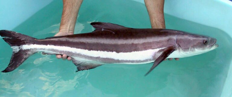
Photo: Jorge Alarcon or Dr. Daniel Benetti, Public domain

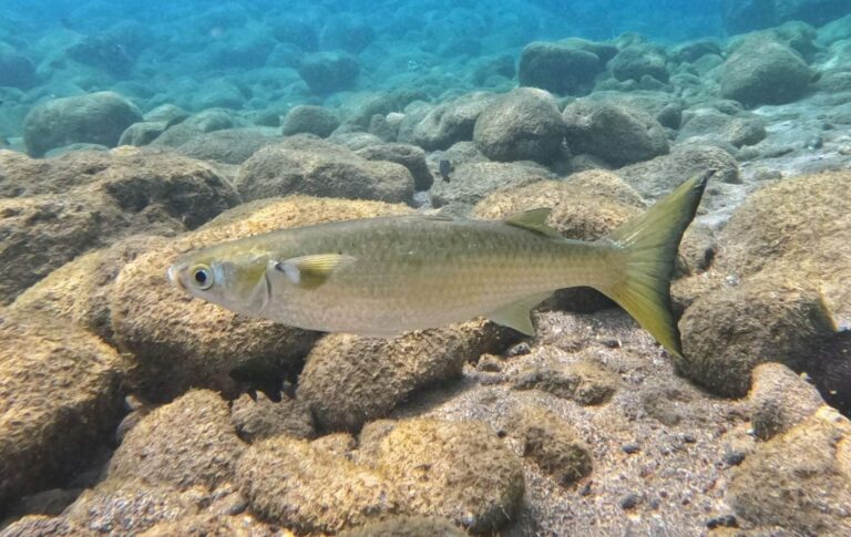
Photo: albertoalcala, CC BY 4.0

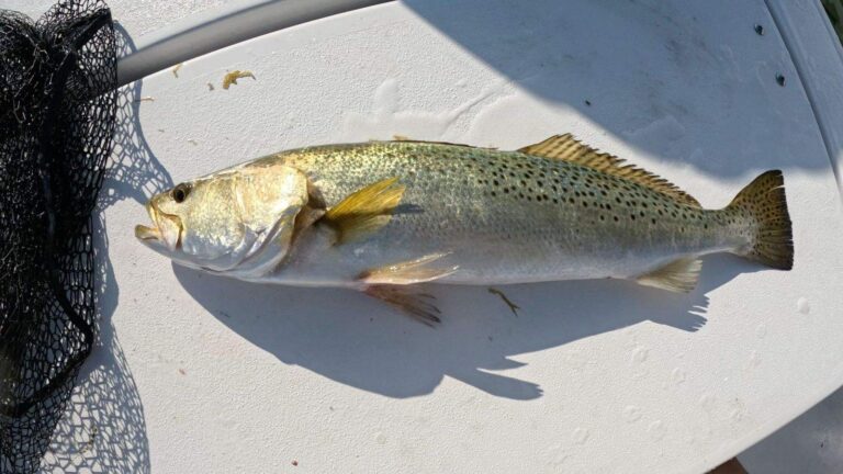
Photo: Rennair, CC BY-SA 4.0


Photo: Totti, CC BY-SA 4.0

Before the drive to Terrebonne Bay, the common questions
Where does Terrebonne Bay sit in Louisiana?
It lies in Terrebonne Parish, about 21 miles from Chauvin.
What license does a visitor need on Terrebonne Bay?
South of the LDWF saltwater line an angler 18 or older carries a Basic Fishing License plus a Saltwater License: $17 and $15 for residents, $68 and $60 for nonresidents.
Which bayou launch runs out to Terrebonne Bay?
Nearest on file: Harbor Light Marina on Lake Barre, 9 miles.
Which 2026 rules apply on Terrebonne Bay?
Cobia (ling or lemonfish): 1 daily per person; no more than 2 per vessel; 36" min fork length; Open year-round in state waters.
Has LDWF built reefs around Terrebonne Bay?
8 sites, starting with Point Mast Reef.
Where can I check the tide at Terrebonne Bay?
NOAA Port Fourchon, Belle Pass covers it.
Can I wade Terrebonne Bay?
The closest pier or bank site is Pointe-aux-Chenes – Island Rd. Wharf on Lake Tambour, Terrebonne Parish, 19 miles off.
Is there a bait stand on the way to Terrebonne Bay?
Gail's Bait Shop, about 23 miles away, is the first bait counter on our Louisiana list.
What passes feed Terrebonne Bay?
Tide runs through Caillou Pass, Cat Island Pass, Old Camp Pass, Pass la Poule and Pass Barre.
Pick a calm day for Terrebonne Bay
Fees, seasons and exceptions are on the saltwater page.