Mississippi River Delta Fishing
A river delta of the Louisiana coast in Plaquemines Parish, inside the LDWF saltwater line.
 Pick for redfishPiscifun Alloy S inshore spinning reelCheck price at Piscifun
Photo of Breton Sound: Louisiana Sea Grant College Program, CC BY 2.0
What the gazetteer and LDWF record about Mississippi River Delta
Mississippi River Delta, a river delta, sits in Plaquemines Parish on the USGS names map. It falls on the salt side of the LDWF line, where saltwater rules apply. The closest Census place is Grand Isle, roughly 47 miles away.
Boaters reach it from 2 launches. Offshore and inshore crews have built 3 reef sites within 25 miles. There are 2 water-level stations in range. The gazetteer maps 20 named passes close by.
USGS Geographic Names Information System (feature class and point), LDWF saltwater line, LDWF launch and Banks and Piers layers; retrieved October 28, 2026.
Features mapped in the Mississippi River Delta
The Mississippi River Delta takes in these named places:
- Mississippi Riverriver mouth (GNIS stream primary point)
- Venicetown
- South Passpass (South Pass)
- Southwest Passpass (Southwest Pass)
- Pass a Loutrepass (Pass a Loutre)
- Main Passpass (Main Pass)
- Baptiste Collette Bayoupass/channel
- Tiger Passpass (Tiger Pass)
- Grand Passpass (Grand Pass)
- Grand Passpass/channel (Grand Pass)
USGS GNIS, DomesticNames_LA; retrieved October 28, 2026.
Fish documented at Mississippi River Delta
Documented catches at Mississippi River Delta; many more species swim there.
LOWA state records and LDWF data; retrieved October 28, 2026.
Where boats go in for Mississippi River Delta
- Cypress Cove Marina on Tiger Pass3-lane concrete ramp, public
- Venice Marina on Tiger Pass3-lane concrete ramp, public
Nearby launches when Mississippi River Delta is busy
- Yellow Cotton Marina on Hospital BayHospital Bay, 13 miles northwest
- Fort Jackson launch on Mississippi RiverMississippi River, 18 miles northwest
LDWF boat launch inventory (saltwater, brackish and freshwater launches), retrieved October 28, 2026.
Where LDWF built reefs by Mississippi River Delta
Near Mississippi River Delta: 3 reef program sites, 0 inshore.
| Reef | Program | Depth | Size | Distance |
|---|---|---|---|---|
| South Pass 37 Reef | offshore | 168-ft | 17 miles south | |
| West Delta 24 Reef | nearshore | 17 miles west | ||
| West Delta 23 Reef | nearshore | 18 miles west |
LDWF Artificial Reef Program saltwater reef layer and site PDFs (depth and acres as printed), retrieved October 28, 2026.
Tide and water level at Mississippi River Delta
NOAA CO-OPS water level, preliminary reading at retrieval (October 28, 2026); station page for live data.
- Pilottowntide predictions, under a mile
- Joseph Bayoutide predictions, 8 miles
- Port Eads, South Passtide predictions, 12 miles
- Devon Energy Facilitytide predictions, 13 miles
On Mississippi River Delta a north wind can drain the flats; watch the gauge, not just the tide table.
NOAA CO-OPS water level and tide prediction stations within 25 and 15 miles, retrieved October 28, 2026.
Where current runs near Mississippi River Delta
- Bienvenue Pass9 miles northeast
- Bruquiere Pass8 miles northeast
- Buoy Pass7 miles northeast
- Cadro Pass7 miles southeast
- Cheniere Pass6 miles southeast
- Cognevich Pass8 miles southeast
- Contrariete Pass9 miles northeast
- Cottam Pass11 miles north
- Dead Women Pass9 miles northeast
- Delta Pass11 miles northeast
- Denesse Pass11 miles north
- Dennis Pass5 miles southeast
- Emeline Pass10 miles north
- Flatboat Pass5 miles northeast
- Garden Island Pass9 miles southeast
- Goose Island Inside Pass5 miles northeast
USGS GNIS passes and guts within 12 miles; retrieved October 28, 2026.
Harbour towns near Mississippi River Delta
- VenicePlaquemines Parish, 10 miles
USGS GNIS coastal towns and fishing ports within 20 miles; retrieved October 28, 2026.
Legal keepers on Mississippi River Delta
| Species | Daily limit and size | Season |
|---|---|---|
| Cobia (ling or lemonfish) | 1 daily per person; no more than 2 per vessel; 36" min fork length | Open year-round in state waters |
| Black drum | 5 daily per person – bag and possession; no more than one over 27" max total length; 16" min total length; 27" max total length | Open year-round in state waters |
| Red drum (redfish) | 4 daily per person – bag; none over 27" max total length; 18" min total length; 27" max total length | Open year-round in state waters |
| Southern flounder | 10 daily per person | Open year-round except no possession allowed from Oct. 15 – Nov. 30 |
| Spanish mackerel | 15 daily per person; 12" min fork length | Open year-round in state waters |
| Striped mullet | 100 lbs. daily | Open year-round in state waters |
| Spotted seatrout (speckled trout) | 15 daily per person with no more than 2 over 20" max total length; 13" min total length; 20" max total length | Open year-round in state waters |
| Sheepshead | No daily limit | Open year-round in state waters |
| Tripletail | 5 daily per person; 18" min total length | Open year-round in state waters |
| Black bass (largemouth and spotted) | 10 daily | Open year-round |
| Striped or hybrid striped bass (or any combination thereof) | 5 daily; no more than two over 30" total length | Open year-round |
| White bass | 50 daily | Open year-round |
| Yellow bass | 50 daily | Open year-round |
| Sunfish (bream) | No daily limit | Open year-round |
| Crappie (black and white) | 50 daily; 100 fish possession limit | Open year-round |
| Bowfin (choupique) | No daily limit; 16" MLL | Open year-round |
The table puts the inshore rules for Mississippi River Delta on top and freshwater rows below.
South of the LDWF saltwater line an angler 18 or older carries a Basic Fishing License plus a Saltwater License: $17 and $15 for residents, $68 and $60 for nonresidents.
Limits and seasons as printed in the 2026 Louisiana Recreational Fishing Regulations (LDWF pamphlet, updated September 21, 2026), page 19 (pamphlet PDF); confirmed on the LDWF saltwater finfish page October 28, 2026.
 For the redfish herePiscifun NautiX saltwater spinning reel14% OFFSale $94.99
LOWA records caught in Mississippi River Delta
| Species | Division | Weight | Angler | Date |
|---|---|---|---|---|
| GROUPER, RED | Rod & Reel | 21.40 lb | Steve Jackson | August 2022 |
Louisiana Outdoor Writers Association state fish records (rank 1 entries; LDWF keeps no record list), retrieved October 28, 2026. All Louisiana records.
Rodeos and events on Mississippi River Delta
Events and weigh-ins on Mississippi River Delta have their own page.
Neighbouring bays measured against Mississippi River Delta
For more launch choices, Bastian Bay offers 5 in the LDWF inventory.
| Water | Distance | Type | Launches | Piers and banks | Reefs within 25 mi | NOAA stations |
|---|---|---|---|---|---|---|
| Mississippi River Delta | river delta | 2 | 0 | 3 | 2 | |
| Breton Sound | 23 miles north | sound | 0 | 0 | 1 | 1 |
| Bastian Bay | 26 miles west | bay | 5 | 1 | 11 | 1 |
| Barataria Pass | 43 miles west | tidal pass | 4 | 7 | 11 | 2 |
| Barataria Bay | 44 miles west | bay | 0 | 0 | 6 | 2 |
| Chandeleur Sound | 50 miles north | sound | 0 | 0 | 2 | 0 |
LDWF launch, Banks and Piers and reef layers, NOAA CO-OPS stations, USGS GNIS; retrieved October 28, 2026.
The country behind Mississippi River Delta
Bayous and rivers feeding toward Mississippi River Delta
- Tiger Pass9 miles
Bait and ice near Mississippi River Delta
- Delta Marinabait and tackle shop, Buras, 26 miles
- Barataria Bait & Tacklebait and tackle shop, Belle Chasse
- Venice Marina Inc, 9262 Highway 23marina, Belle Chasse
- Wharves & Docks Comarina, Belle Chasse
- Buras Boat Harbor Guard Shackmarina, Buras
- Joshuas Marina Incmarina, Buras
Booked trips to Mississippi River Delta
- Born to Fish Charterscharter, Buras, (504) 908-3108
- Cajun Culture Fishing Adventurescharter, Buras, (504) 872-2204
- Carpe Diem Fishingcharter, Buras, (228) 493-2913
- Champion Fishing Charterscharter, Venice, (318) 730-4410
- Deep Delta Bowfishingcharter, Port Sulphur, (504) 656-0006
- Fish Intimidator Pro Guide Service Inccharter, Buras, (504) 416-6731
- Kingdom Charterscharter, Buras, (504) 756-9254
- Louisiana Tuna Charterscharter, Venice, (504) 814-4290
Parish pages that list Mississippi River Delta
- Plaquemines Parishseat: Pointe à la Hache
Reels and line from Piscifun ahead of Mississippi River Delta


Piscifun and Amazon links are affiliate links; the site earns a commission on qualifying purchases.
Fish to recognise before a trip to Mississippi River Delta
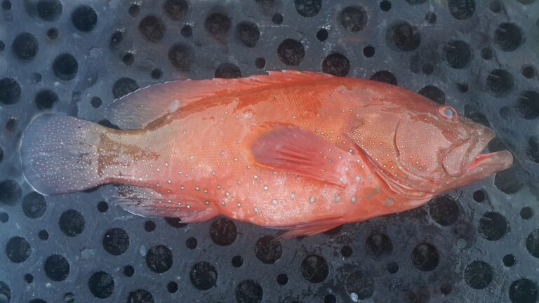
Photo: Challiyan, CC BY-SA 3.0


Photo: Stefanie Tellex. (talk) (Uploads), Public domain

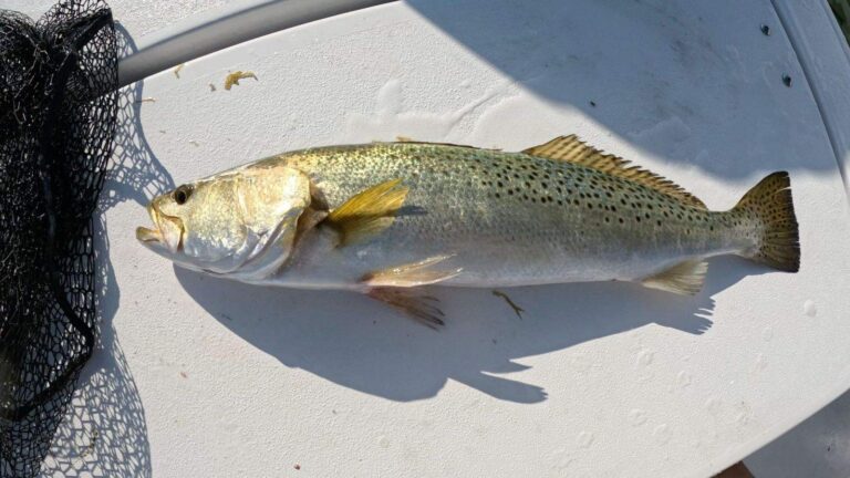
Photo: Rennair, CC BY-SA 4.0

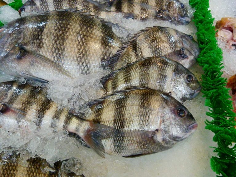
Photo: Rusty Clark ~ 100K Photos, CC BY 2.0
What first-timers on Mississippi River Delta want to know
Which parish holds Mississippi River Delta?
The gazetteer point is in Plaquemines Parish, about 47 miles from Grand Isle.
Do I need a saltwater license for Mississippi River Delta?
South of the LDWF saltwater line an angler 18 or older carries a Basic Fishing License plus a Saltwater License: $17 and $15 for residents, $68 and $60 for nonresidents.
Where do bay boats put in for Mississippi River Delta?
LDWF lists 2 launches, Cypress Cove Marina on Tiger Pass among them.
Which creel limits cover Mississippi River Delta?
Cobia (ling or lemonfish): 1 daily per person; no more than 2 per vessel; 36" min fork length; Open year-round in state waters.
How many reefs lie near Mississippi River Delta?
South Pass 37 Reef is nearest of 3 sites.
How high is the water on Mississippi River Delta?
Use Pilottown, shown in the tide band.
Does LDWF map a pier on Mississippi River Delta?
Plan on a boat; no pier is listed near.
Where can I pick up shiners near Mississippi River Delta?
Closest on our Louisiana list: Delta Marina, about 26 miles away.
Which cuts are near Mississippi River Delta?
Within 12 miles: Bienvenue Pass, Bruquiere Pass, Buoy Pass, Cadro Pass and Cheniere Pass.
Is Mississippi River Delta in the LOWA record book?
GROUPER, RED, 21.40 lb, by Steve Jackson (August 2022).
Put Mississippi River Delta on the inshore list
Check the wind and tide, then pick the launch nearest your target.